
- CN 62-1070/P
- ISSN 1000-694X
- Bimonthly 1981
Journal of Desert Research ›› 2025, Vol. 45 ›› Issue (5): 230-240.DOI: 10.7522/j.issn.1000-694X.2025.00129
Siqi Li1( ), Haibing Wang1,2,3(), Xiaofei Yuan1, Huricha Ao1, Haoqin Yang1
Received:2025-04-30
Revised:2025-06-27
Online:2025-09-20
Published:2025-09-27
Contact:
Haibing Wang
CLC Number:
Siqi Li, Haibing Wang, Xiaofei Yuan, Huricha Ao, Haoqin Yang. Temporal and spatial evolution of landscape ecological risks and driving forces in the Mu Us Sandy Land[J]. Journal of Desert Research, 2025, 45(5): 230-240.
Add to citation manager EndNote|Ris|BibTeX
URL: http://www.desert.ac.cn/EN/10.7522/j.issn.1000-694X.2025.00129
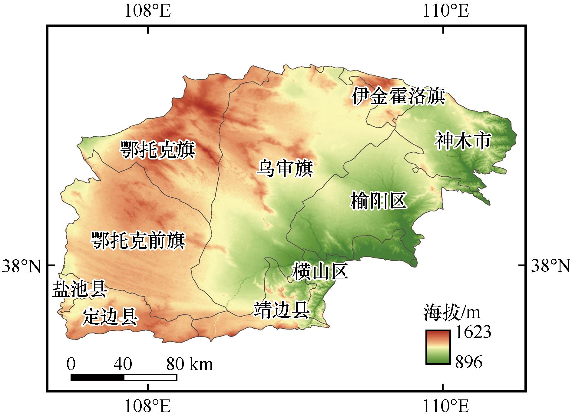
Fig.1 Overview of the research area
| 序号 | 景观类型 | 脆弱度分级 | 景观脆弱度 |
|---|---|---|---|
| 1 | 耕地 | 4 | 0.190 |
| 2 | 林地 | 2 | 0.095 |
| 3 | 草地 | 3 | 0.143 |
| 4 | 水域 | 5 | 0.238 |
| 5 | 未利用地 | 6 | 0.286 |
| 6 | 建设用地 | 1 | 0.048 |
Table 1 Vulnerability classification of various landscape types
| 序号 | 景观类型 | 脆弱度分级 | 景观脆弱度 |
|---|---|---|---|
| 1 | 耕地 | 4 | 0.190 |
| 2 | 林地 | 2 | 0.095 |
| 3 | 草地 | 3 | 0.143 |
| 4 | 水域 | 5 | 0.238 |
| 5 | 未利用地 | 6 | 0.286 |
| 6 | 建设用地 | 1 | 0.048 |
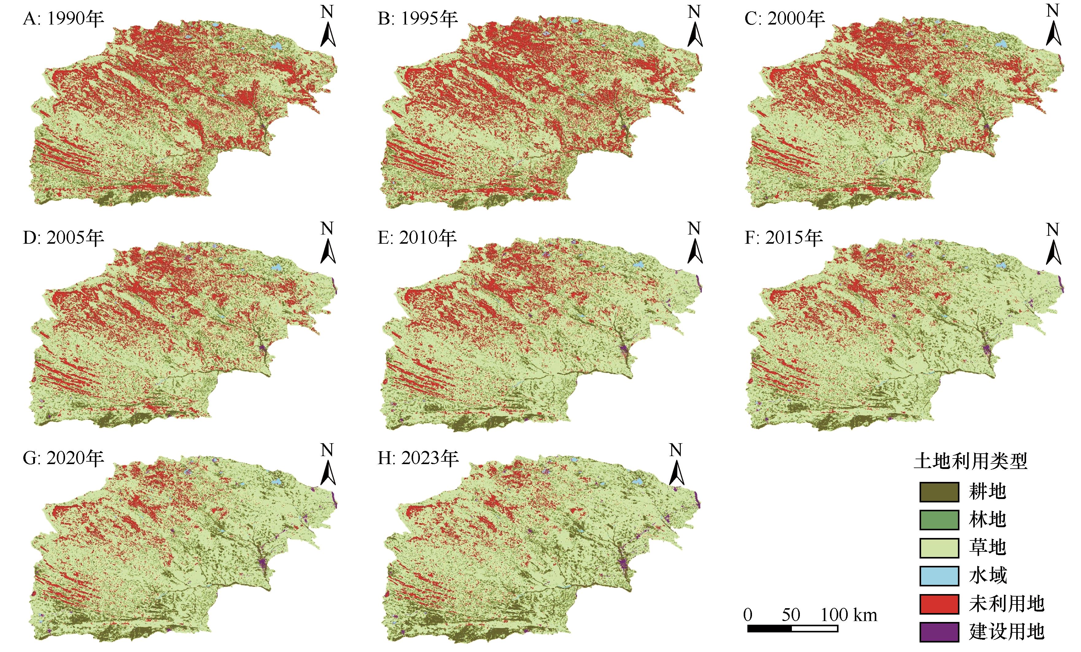
Fig.2 Spatial distribution map of landscape types in the Mu Us Sandy Land
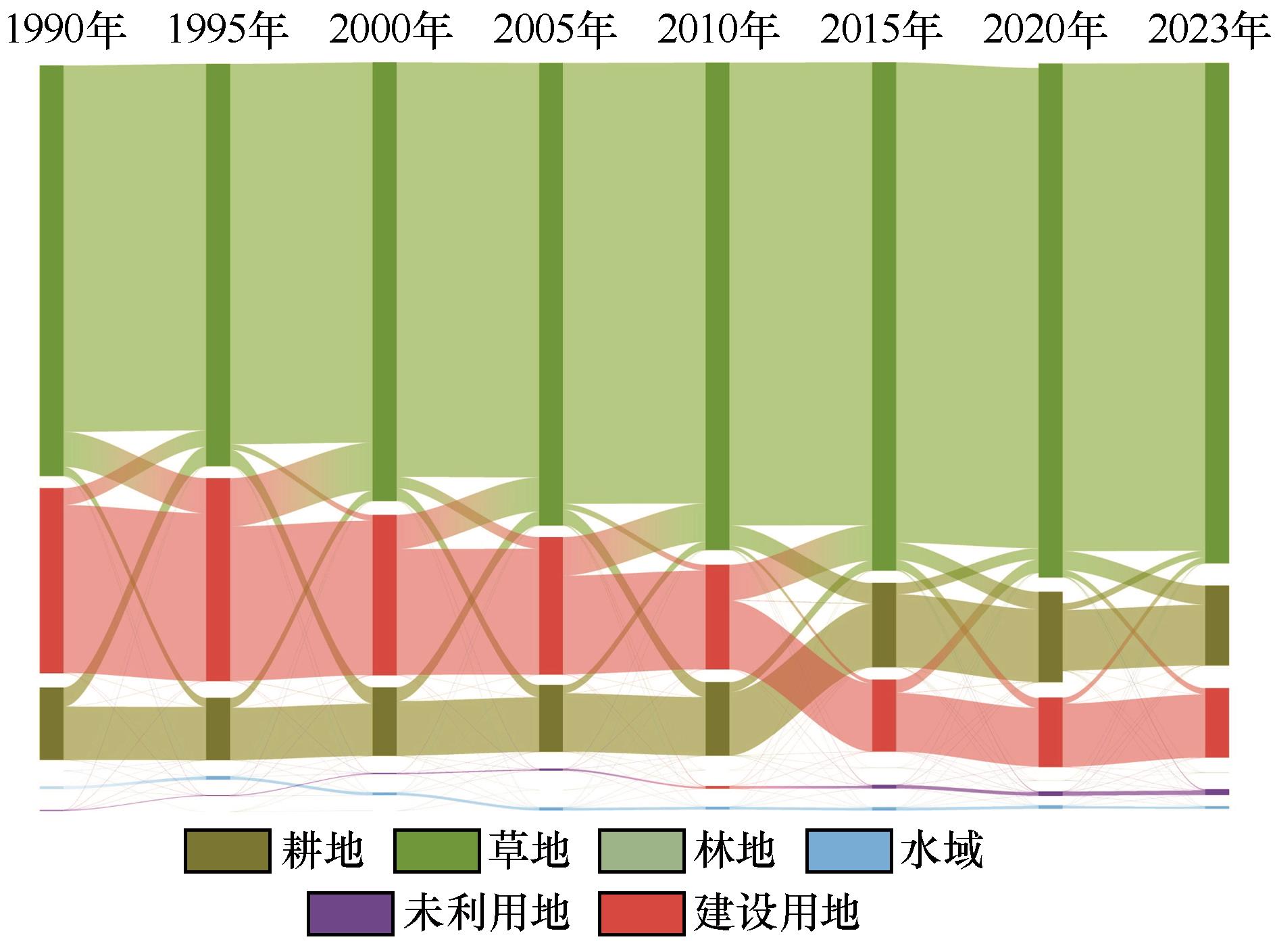
Fig.3 Sankey diagram of land-use type transfer
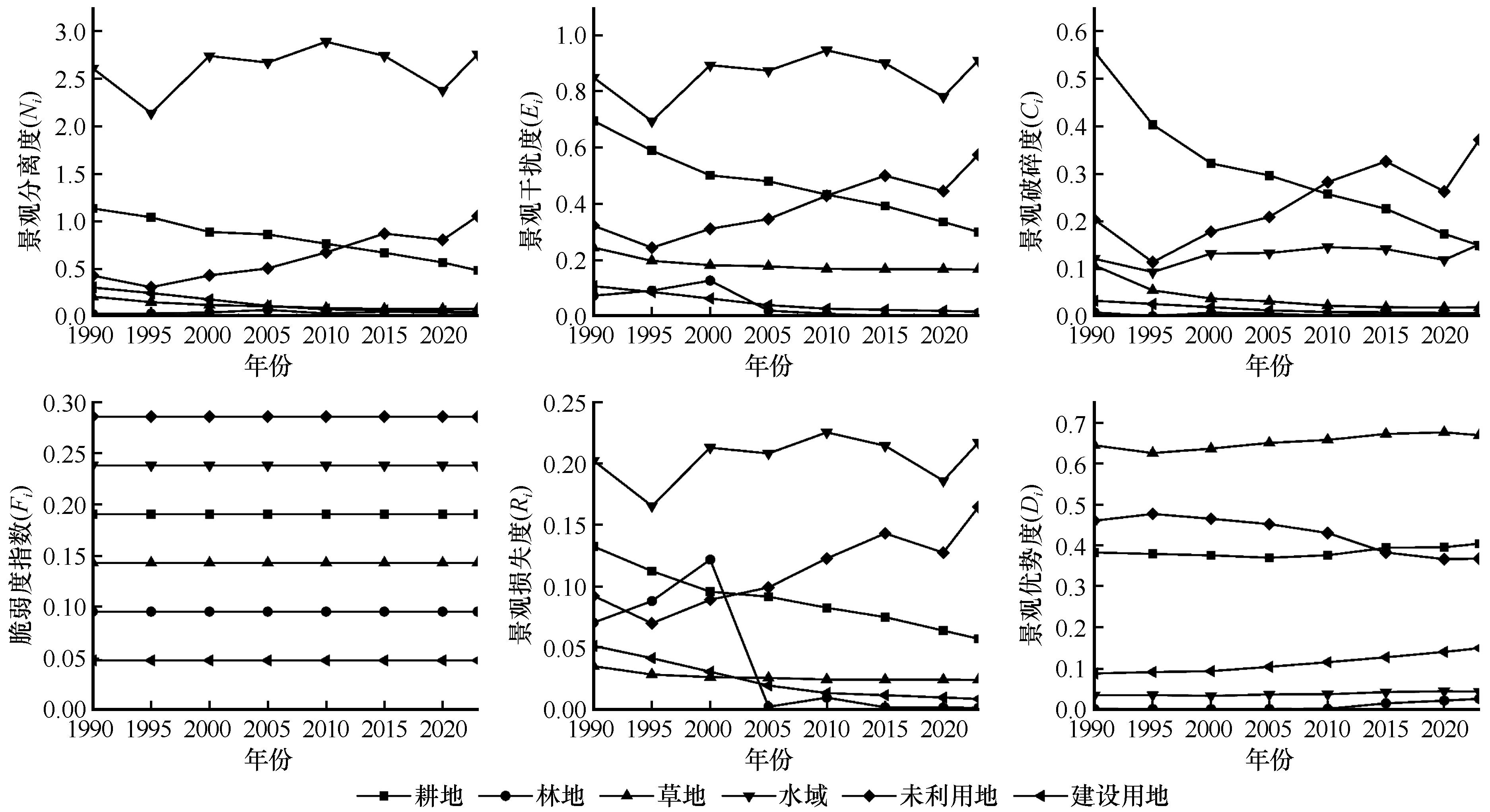
Fig.4 Time series chart of landscape pattern indices in the Mu Us Sandy Land
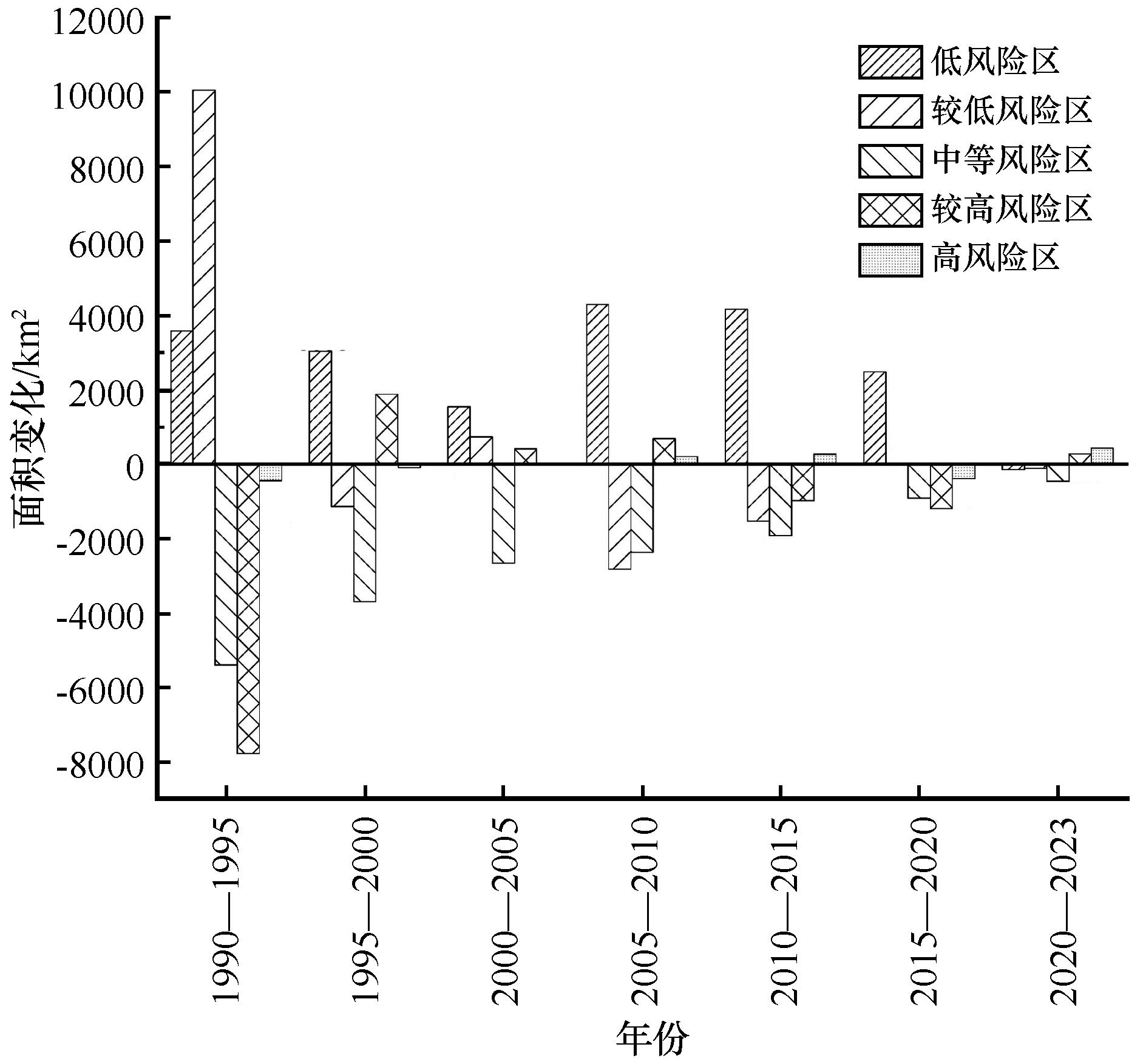
Fig.5 Landscape ecological risk area changes in the Mu Us Sandy Land
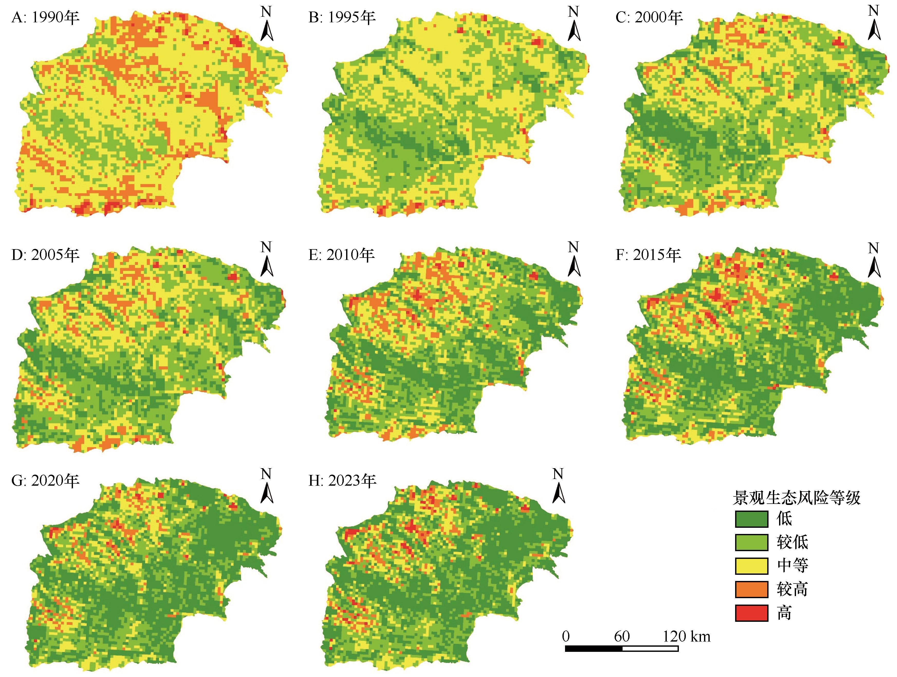
Fig.6 Spatial distribution of landscape ecological risks in the Mu Us Sandy Land
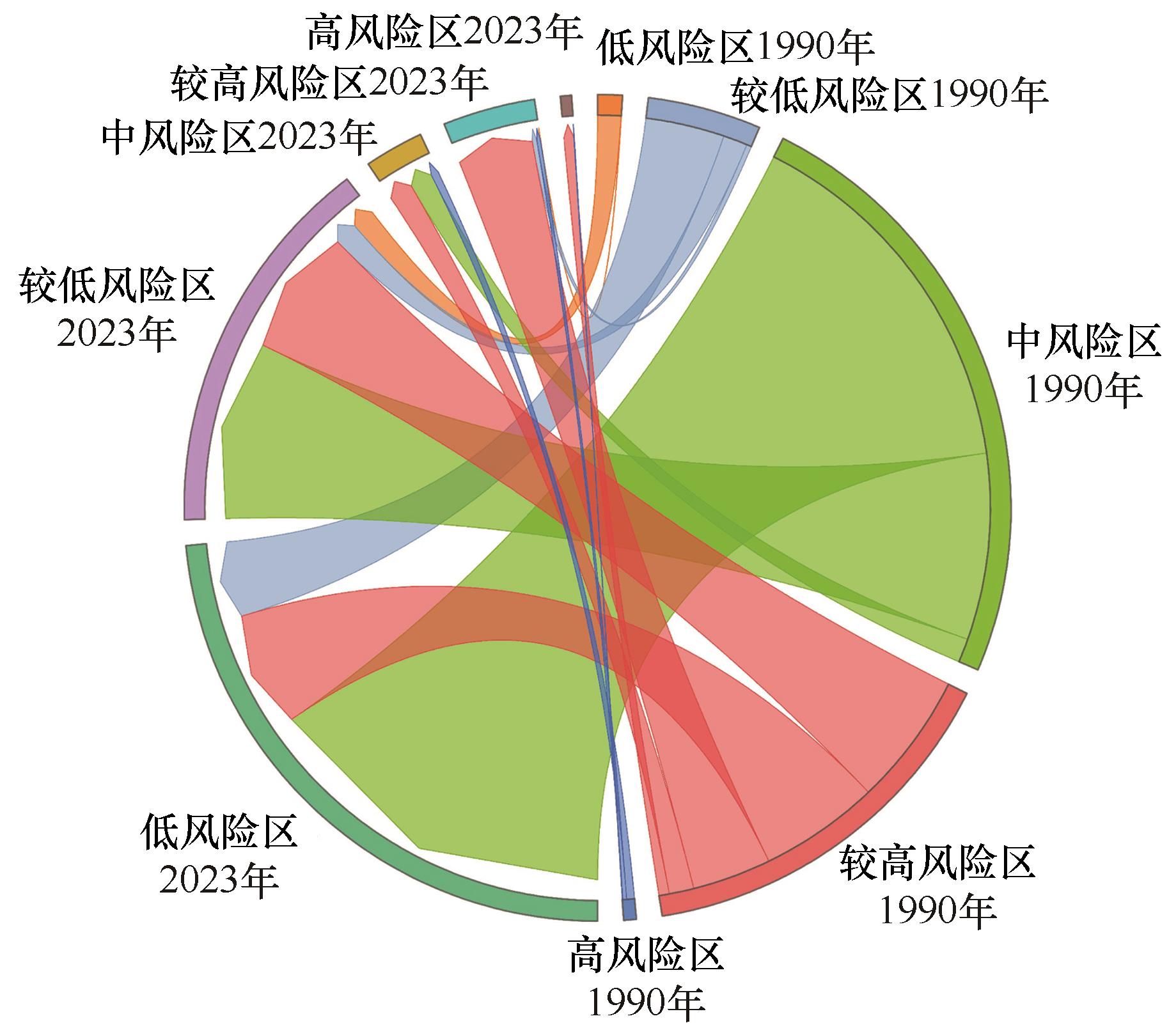
Fig.7 Sankey diagram of ecological risk transfer matrix from 1990 to 2023
| 生态风险等级 | 低 | 较低 | 中等 | 较高 | 高 | 1990年总计 |
|---|---|---|---|---|---|---|
| 低 | 0.00 | 0.86 | 0.00 | 0.01 | 0.00 | 0.87 |
| 较低 | 2.93 | 0.90 | 0.00 | 0.18 | 0.00 | 4.01 |
| 中等 | 13.88 | 6.92 | 0.88 | 0.00 | 0.00 | 21.67 |
| 较高 | 4.45 | 4.95 | 0.92 | 2.93 | 0.38 | 13.63 |
| 高 | 0.00 | 0.00 | 0.29 | 0.14 | 0.02 | 0.45 |
| 2023年总计 | 21.26 | 13.63 | 2.08 | 3.27 | 0.40 | 40.63 |
| 面积净变化 | 20.39 | 9.61 | -19.59 | -10.36 | -0.05 | 0.00 |
Table 2 Ecological risk transfer matrix, 1990-2023
| 生态风险等级 | 低 | 较低 | 中等 | 较高 | 高 | 1990年总计 |
|---|---|---|---|---|---|---|
| 低 | 0.00 | 0.86 | 0.00 | 0.01 | 0.00 | 0.87 |
| 较低 | 2.93 | 0.90 | 0.00 | 0.18 | 0.00 | 4.01 |
| 中等 | 13.88 | 6.92 | 0.88 | 0.00 | 0.00 | 21.67 |
| 较高 | 4.45 | 4.95 | 0.92 | 2.93 | 0.38 | 13.63 |
| 高 | 0.00 | 0.00 | 0.29 | 0.14 | 0.02 | 0.45 |
| 2023年总计 | 21.26 | 13.63 | 2.08 | 3.27 | 0.40 | 40.63 |
| 面积净变化 | 20.39 | 9.61 | -19.59 | -10.36 | -0.05 | 0.00 |
| 影响因素 | 因子 | 年份 | |||||||
|---|---|---|---|---|---|---|---|---|---|
| 1990 | 1995 | 2000 | 2005 | 2010 | 2015 | 2020 | 2023 | ||
自然 因素 | 归一化植被指数 | — | — | 31.68 | 32.17 | 33.80 | 29.97 | 29.82 | 33.25 |
| 高程 | 3.55 | 3.55 | 3.26 | 5.33 | 11.89 | 12.16 | 10.35 | 9.47 | |
| 坡度 | 0.21 | 0.21 | 0.41 | 0.10 | 0.24 | 0.17 | 0.18 | 0.12 | |
| 年降水量 | 5.29 | 5.29 | 8.39 | 5.79 | 15.23 | 8.76 | 13.07 | 12.89 | |
| 年平均气温 | 5.29 | 5.29 | 7.35 | 6.66 | 9.38 | 8.77 | 6.67 | 5.67 | |
社会 经济 因素 | GDP密度 | 2.96 | 2.96 | 2.75 | 2.26 | 1.52 | 1.47 | 1.18 | — |
| 人口密度 | 4.48 | 4.48 | 1.35 | 5.98 | 11.33 | 12.85 | 8.45 | — | |
| 夜间灯光指数 | 4.48 | 4.48 | 5.40 | 2.99 | 1.03 | 1.81 | 1.72 | — | |
| 人为干扰度 | 3.92 | 3.92 | 0.14 | 2.18 | 1.53 | 1.26 | 1.54 | 1.18 | |
Table 3 One-factor contributions to drivers of landscape ecological risk in the Mu Us Sandy Land, 1990 -2023
| 影响因素 | 因子 | 年份 | |||||||
|---|---|---|---|---|---|---|---|---|---|
| 1990 | 1995 | 2000 | 2005 | 2010 | 2015 | 2020 | 2023 | ||
自然 因素 | 归一化植被指数 | — | — | 31.68 | 32.17 | 33.80 | 29.97 | 29.82 | 33.25 |
| 高程 | 3.55 | 3.55 | 3.26 | 5.33 | 11.89 | 12.16 | 10.35 | 9.47 | |
| 坡度 | 0.21 | 0.21 | 0.41 | 0.10 | 0.24 | 0.17 | 0.18 | 0.12 | |
| 年降水量 | 5.29 | 5.29 | 8.39 | 5.79 | 15.23 | 8.76 | 13.07 | 12.89 | |
| 年平均气温 | 5.29 | 5.29 | 7.35 | 6.66 | 9.38 | 8.77 | 6.67 | 5.67 | |
社会 经济 因素 | GDP密度 | 2.96 | 2.96 | 2.75 | 2.26 | 1.52 | 1.47 | 1.18 | — |
| 人口密度 | 4.48 | 4.48 | 1.35 | 5.98 | 11.33 | 12.85 | 8.45 | — | |
| 夜间灯光指数 | 4.48 | 4.48 | 5.40 | 2.99 | 1.03 | 1.81 | 1.72 | — | |
| 人为干扰度 | 3.92 | 3.92 | 0.14 | 2.18 | 1.53 | 1.26 | 1.54 | 1.18 | |
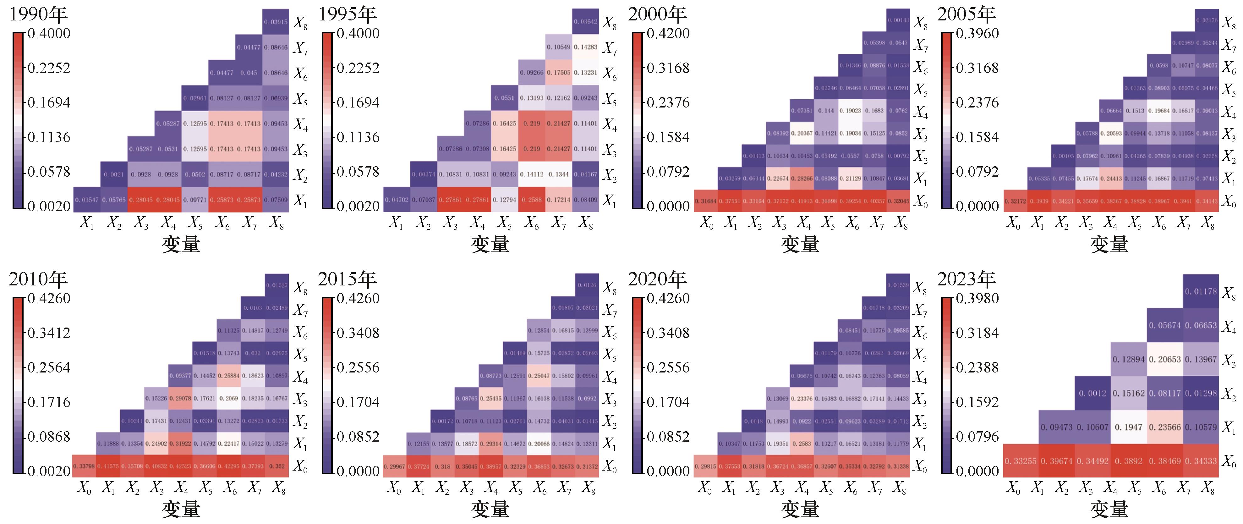
Fig.8 Interaction detection process of landscape ecological risk drivers in the Mu Us Sandy Land
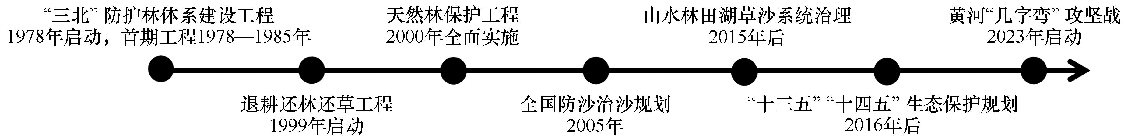
Fig.9 Timeline of the launch of relevant policies in the Mu Su Sandy Land
| 风险等级 | 主导因子 | 管理建议 |
|---|---|---|
| 低风险区 | 单因子:NDVI; 交互因子:NDVI∩人口密度 | 确定生态红线,合理调配人、生产和生态空间等 |
| 较低风险区 | 协调减少人类对生态环境的影响、建立生态政策补偿机制等 | |
| 中等风险区 | 采取防沙治沙措施、建立生态政策补偿机制等 | |
| 较高风险区 | 建立自然保护区、采取防沙治沙措施等 | |
| 高风险区 | 建立自然保护区等 |
Table 4 Ecological management measures corresponding to risk levels in the Mu Su Sandy Land
| 风险等级 | 主导因子 | 管理建议 |
|---|---|---|
| 低风险区 | 单因子:NDVI; 交互因子:NDVI∩人口密度 | 确定生态红线,合理调配人、生产和生态空间等 |
| 较低风险区 | 协调减少人类对生态环境的影响、建立生态政策补偿机制等 | |
| 中等风险区 | 采取防沙治沙措施、建立生态政策补偿机制等 | |
| 较高风险区 | 建立自然保护区、采取防沙治沙措施等 | |
| 高风险区 | 建立自然保护区等 |
| [1] | Foley J A, DeFries R, Asner G P,et al.Global consequences of land use[J].Science,2005,309:570-574. |
| [2] | Yan H M, Liu J Y, Huang H Q,et al.Assessing the consequence of land use change on agricultural productivity in China[J].Global and Planetary Change,2009,67:13-19. |
| [3] | 程静,王鹏,陈红翔,等.半干旱区生态风险时空演变及其影响因素的地理探测:以宁夏盐池县为例[J].干旱区地理,2022,45(5):1637-1648. |
| [4] | 王帅,傅伯杰,武旭同,等.黄土高原社会-生态系统变化及其可持续性[J].资源科学,2020,42(1):96-103. |
| [5] | Wang M B, Ding S, Li L,et al.Assessment of landscape ecological risk for a cross-border basin:a case study of the Koshi River Basin,central Himalayas[J].Ecological Indicators,2020,117:106621. |
| [6] | Peng J, Dang W, Liu Y,et al.Review on landscape ecological risk assessment[J].Acta Geographica Sinica,2015,70(4):664-677. |
| [7] | Wu S, Wei J, He Z,et al.Research progress in ecological risk assessment of mining cities[J].Safety and Environmental Engineering,2022,29(1):207-217. |
| [8] | Hope B K.An examination of ecological risk assessment and management practices[J].Environment International,2006,32(8):983-995. |
| [9] | Zhang J, Zheng S, Sun Y,et al.Landscape ecological risk assessment of an ecological area in the Kubuqi desert based on Landsat remote sensing data[J].PLoS ONE,2023,18(11):e0294584. |
| [10] | Fan J, Wang Y, Zhou Z,et al.Dynamic ecological risk assessment and management of land use in the middle reaches of the Heihe River Based on landscape patterns and spatial statistics[J].Sustainability,2016,8:536. |
| [11] | Zhang X B, Shi P J, Luo J,et al.The ecological risk assessment of arid inland river basin at the landscape scale:a case study on Shiyang River Basin[J].Journal of Natural Resources,2014,29:410-419. |
| [12] | Wang W Q, Li T H.Temporal and spatial variation of ecological risk analysis in Yunnan Province based on land use spatial structure[J].Acta Scientiarum Naturalium Universitatis Pekinensis,2014,50:355-360. |
| [13] | Chen S Q, Chen B, Fath B D.Ecological risk assessment on the system scale:a review of state-of-the-art models and future perspectives[J].Ecological Modelling,2013,250:25-33. |
| [14] | 张学斌,石培基,罗君,等.基于景观格局的干旱内陆河流域生态风险分析:以石羊河流域为例[J].自然资源学报,2014,29(3):410-419. |
| [15] | 黄博,张海文.关中平原城市群景观生态风险演变及驱动力分析[J].环境生态学,2024,6(6):40-48. |
| [16] | 程玉卓,王志杰,班先娅,等.城市化和生态文明建设对喀斯特山地城市景观生态风险的影响评价:以贵阳市花溪区为例[J].水土保持研究,2023,30(5):351-357. |
| [17] | Luk S H.Recent trends of desertification in the Maowusu Desert,China[J].Environmental Conservation,1983,10(3):213-224. |
| [18] | 王婕.生态文明视域下我国沙地生态治理研究[D].成都:电子科技大学,2021. |
| [19] | 萨仁高娃,赵媛媛,耿鑫智,等.内蒙古沙区2000-2020年人地系统可持续性[J].中国沙漠,2025,45(2):71-82. |
| [20] | 王鹏,王亚娟,刘小鹏,等.基于景观结构的生态移民安置区生态风险评价:以宁夏红寺堡区为例[J].生态学报,2018,38(8):2672-2682. |
| [21] | 苏海民,何爱霞.基于RS和地统计学的福州市土地利用分析[J].自然资源学报,2010,25(1):91-99. |
| [22] | 高彬嫔,李琛,吴映梅,等.川滇生态屏障区景观生态风险评价及影响因素[J].应用生态学报,2021,32(5):1603-1613. |
| [23] | 吕乐婷,张杰,孙才志,等.基于土地利用变化的细河流域景观生态风险评估[J].生态学报,2018,38(16):5952-5960. |
| [24] | 王劲峰,徐成东.地理探测器:原理与展望[J].地理学报,2017,72(1):116-134. |
| [25] | 杨永梅,郭志林,杨改河.自然和人为因素对毛乌素沙地沙漠化的耦合作用[J].安徽农业科学,2010,38(25):13934-13935. |
| [26] | Karimian H, Zou W, Chen Y,et al.Landscape ecological risk assessment and driving factor analysis in Dongjiang River watershed[J].Chemosphere,2022,307:135835. |
| [27] | 修晓敏,吴波,费兵强,等.基于Meta分析的毛乌素沙地荒漠化动态研究[J].干旱区地理,2024,47(12):2051-2063. |
| [28] | Gao S, Wu J, Ma L,et al.Introduction to sand-restoration technology and model in China[J].Sustainability,2023,15:98. |
| [29] | Mu S J, Zhou S X, Chen Y Z,et al.Assessing the impact of restoration-induced land conversion and management alternatives on net primary productivity in Inner Mongolian grassland,China[J].Global and Planetary Change,2013,108:29-41. |
| [30] | Li Z, Xu B, Tian D,et al.Long-term analysis of regional vegetation correlation with climate and phenology in the midsection of Maowusu Sand Land[J].Water,2024,16:623. |
| [31] | 冯佳新,吴月茹,乔硕,等.毛乌素沙地沙漠化逆转过程中土壤组分及微量元素含量变化特征[J].中国沙漠,2024,44(1):218-227. |
| [32] | Zhao Y, Kasimu A, Liang H,et al.Construction and restoration of landscape ecological network in Urumqi city based on landscape ecological risk assessment[J].Sustainability,2022,14:8154. |
| [33] | Wang S, Tan X, Fan F.Landscape ecological risk assessment and impact factor analysis of the Qinghai-Tibetan Plateau[J].Remote Sensing,2022,14:4726. |
| [34] | Yan Z, Wang Y, Wang Z,et al.Spatiotemporal analysis of landscape ecological risk and driving factors:a case study in the Three Gorges Reservoir Area,China[J].Remote Sensing,2023,15:4884. |
| [35] | Li X, Li S, Zhang Y,et al.Landscape ecological risk assessment under multiple indicators[J].Land,2021,10:739. |
| [36] | Yao Q, Zheng D, Yan Y,et al.Ecological risk assessment models for simulating impacts of land use and landscape pattern on ecosystem services[J].Science of the Total Environment,2022,833:155218. |
| [37] | 潘景璐,周建华.环境退化地区家庭人口对土地利用的影响研究:以中国西北毛乌素沙地为例[J].西北人口,2012,33(2):6-10. |
| [38] | Chang S, Wei Y, Dai Z,et al.Landscape ecological risk assessment and its driving factors in the Weihe River Basin,China[J].Journal of Arid Land,2024,16(5):603-614. |
| [39] | Xia Y, Li J, Li E,et al.Analysis of the spatial and temporal evolution and driving factors of landscape ecological risk in the Four Lakes Basin on the Jianghan Plain,China[J].Sustainability,2023,15:13806. |
| [40] | 荣维康,徐天乐,葛小东,等.2000-2020年湖北省土地利用变化对植被覆盖度的影响[J].水土保持通报,2024,44(1):238-246. |
| [1] | Pengfei Zhang, Jiaqi Han, Zhenjiang Zhao, Yanyan Dai, Geng Liu, Jinlong Chao, Lei Zhang. Coupling characteristics and the driving factors of agricultural water poverty and food production vulnerability in Fenhe River basin, China [J]. Journal of Desert Research, 2025, 45(5): 13-23. |
| [2] | Shiyao Zhong, Chuanhua Li, Pengfei Qiao. Vegetation abrupt changes and attribution in the arid and semi-arid regions of Northwest China under aridity gradients from 2000 to 2020 [J]. Journal of Desert Research, 2025, 45(2): 275-283. |
| [3] | Yanyan Dai, Yiting Jiang, Pengfei Zhang, Geng Liu, Lei Zhang. Coupling coordination and driving factors between water resources and planting structure in Shanxi, China [J]. Journal of Desert Research, 2024, 44(6): 37-47. |
| [4] | Ziao Shen, Jing Wu, Chunbin Li. Temporal and spatial changes of vegetation cover and its driving forces in the Hexi inland river basin from 2000 to 2020 [J]. Journal of Desert Research, 2024, 44(3): 119-127. |
| [5] | Wei Hang, Yongxing Lu, Hao Guo, Xing Guo, Shihang Zhang, Yuanming Zhang, Xiaobing Zhou. Spatial variation in soil nitrogen content along aridity gradients in the northwest desert region in China [J]. Journal of Desert Research, 2024, 44(3): 259-268. |
| [6] | Tiaoxue Lu, Linshan Yang, Qi Feng, Meng Zhu, Naiyu Li. The change of oasis structure / scale and its influencing factors in Zhangye Basin in recent 20 years [J]. Journal of Desert Research, 2023, 43(6): 131-141. |
| [7] | Shilin Fu, Jiaqiang Lei, Yiqi Zhou, Na Zhou, Malicha Loje Hare, Zinabu Bora Jorro. Analysis of land degradation trends and driving factors in Ethiopia based on NPP-WUE [J]. Journal of Desert Research, 2023, 43(1): 128-141. |
| [8] | Xiaoyun Cheng, Qin Zhang, Fangfang Lan, Yuan Li, Yaxuan Han, Limin Zhang, Yanke Yang, Xinyuan Wang. Dynamic characteristics and driving factors of grassland desertification in Hexi Corridor [J]. Journal of Desert Research, 2022, 42(6): 134-141. |
| [9] | Yun Chen, Yuqiang Li, Xuyang Wang, Caiping Yao, Yayi Niu. Risk and countermeasures of global change in ecologically vulnerable regions of China [J]. Journal of Desert Research, 2022, 42(3): 148-158. |
| [10] | Yongdao Gao, Rongrong Qiao, Shuxin Ji, Xuelian Bai, Lixiang Wang, Xueli Chang. Changes and driving factors of crops planting structure in Hetao Irrigation Region in Inner Mongolia [J]. Journal of Desert Research, 2021, 41(3): 110-117. |
| [11] | Yao Wenyi, Zhang Xiaohua, Gao Yajun, Jiao Peng. Features of Runoff and Sediment Variations in Wide-valleyed Desert Reach of Upper Yellow River and Contribution Rate of Driving Factors for the Variations [J]. JOURNAL OF DESERT RESEARCH, 2017, 37(2): 361-371. |
| [12] | Gao Guanlong, Zhang Xiaoyou, Yu Tengfei, Li Xiaoqin. Land Cover Change and Its Driving Factors in the Ejin Oasis during 1987-2008 [J]. JOURNAL OF DESERT RESEARCH, 2015, 35(3): 821-829. |
| [13] | Li Xiaoying, Yao Zhengyi, Wang Hongwei, Xiao Jianhua. The Driving Mechanism of Sandy Desertification in the Zoige Basin of China [J]. JOURNAL OF DESERT RESEARCH, 2015, 35(1): 51-59. |
| [14] | Huang Lei, Zhang Zhishan, Hu Yigang, Yang Haotian. Soil CO2 Concentration under Different Types of Plant Communities and the Driving Factors in Arid Desert Area [J]. JOURNAL OF DESERT RESEARCH, 2014, 34(1): 125-132. |
| [15] | HUANG Yin-zhou1,2, WANG Nai-ang1, CHENG Hong-yi1, MA Ning1, LAI Ting-ting1. Historical Desertification in the Mu Us Sandy Land: An analysis on grain size data from the Beidachi section [J]. JOURNAL OF DESERT RESEARCH, 2013, 33(2): 426-432. |
| Viewed | ||||||
|
Full text |
|
|||||
|
Abstract |
|
|||||
©2018Journal of Desert Research
Tel:0931-8267545
Email:caiedit@lzb.ac.cn;desert@lzb.ac.cn
Support:Magtech