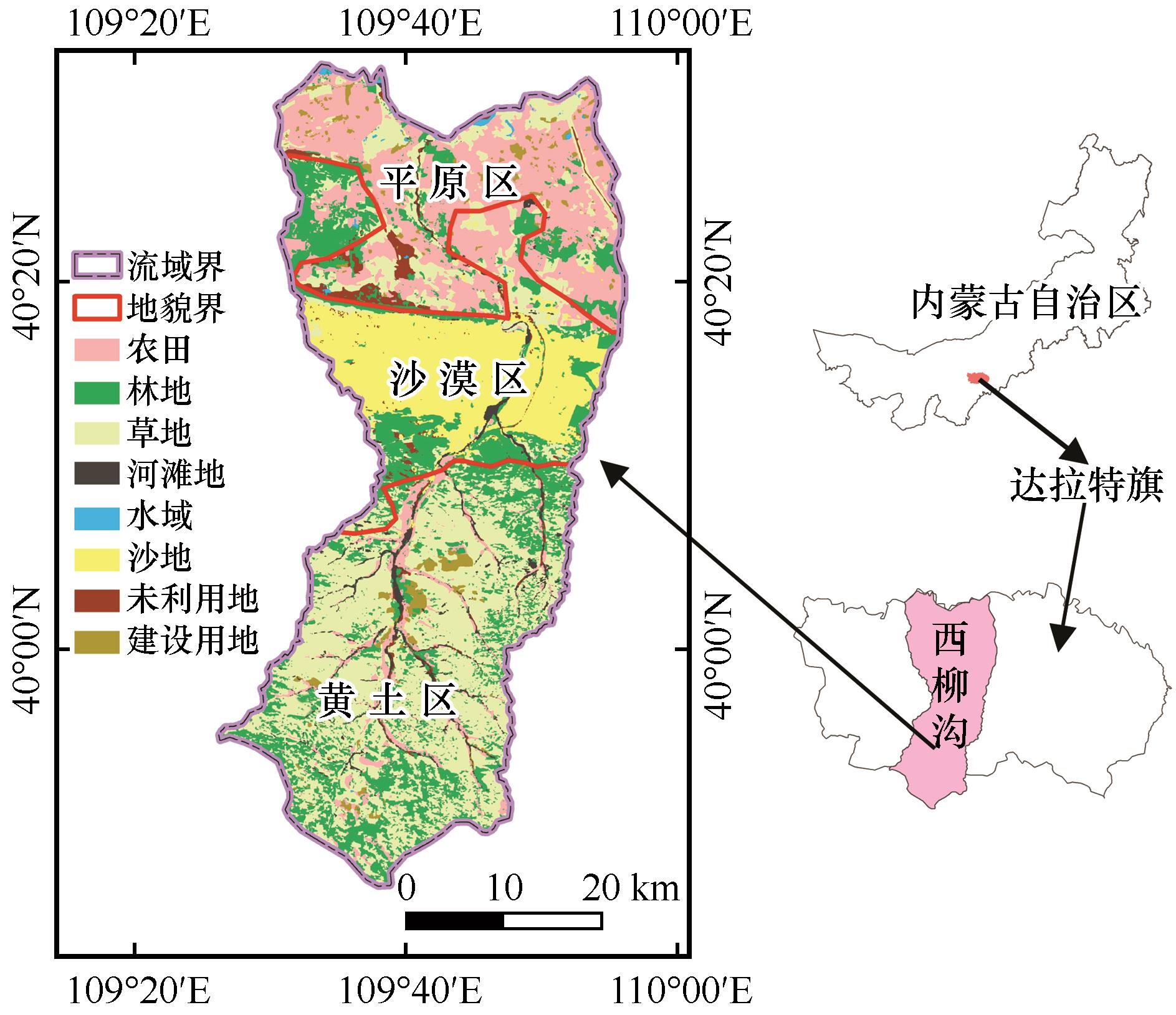
| [1] |
Jingliang Chen, Chao Liu, Lei Huang.
Assessment and dynamic simulation of the forest ecosystem services value in the Luoshan Nature Reserve of Ningxia
[J]. Journal of Desert Research, 2026, 46(2): 155-163.
|
| [2] |
Lutong Wan, Xiaodan Liu, Hanqing Guo, Wanlai Xue, Kexuan Liu, Jin Li, Lili Wang, Honghao Liu.
Multi-scale characteristics and driving factors of trade-off / synergy of ecosystem services in the ecological conservation area of western Beijing
[J]. Journal of Desert Research, 2025, 45(6): 206-219.
|
| [3] |
Tong Li, Rui Zhu, Xiaoguang Li, Jian Kang, Jian'an Shan, Rong Li, Zhenliang Yin.
Research on soil and water conservation in the Zuli River Basin based on the InVEST model
[J]. Journal of Desert Research, 2025, 45(6): 312-322.
|
| [4] |
Jianpeng Zhang, Luming Lei, Yuqiang Li, Tianai Li, Xueyong Zhao, Haotong Ren, Hong Jia, Yangyang Wang, Lihan Cui.
Sustainability assessment of human-earth systems from ecosystem service supply-demand perspectives: evidence from Horqin Sandy Land, China
[J]. Journal of Desert Research, 2025, 45(4): 176-189.
|
| [5] |
Delong Zhou, Yongfang Wang, Enliang Guo, Ying Hong, Haowen Ma, Quanfei Mu, Yanli Wang.
Evolution and prediction of habitat quality in the Horqin Sandy Land
[J]. Journal of Desert Research, 2025, 45(4): 211-226.
|
| [6] |
Hong Jia, Jianpeng Zhang, Lianyou Liu, Jifu Liu, Siqi Yang.
Variation and multi-scenario simulation of habitat quality in the Gonghe Basin, China
[J]. Journal of Desert Research, 2025, 45(2): 29-36.
|
| [7] |
Aokang Xu, Tianqi Ji, Jing Shi.
Construction and optimization of ecological network of the Heihe River Basin (Gansu section)
[J]. Journal of Desert Research, 2025, 45(2): 61-70.
|
| [8] |
Hong Jia, Lianyou Liu, Jifu Liu.
Desertification sensitivity assessment in the Gonghe Basin
[J]. Journal of Desert Research, 2025, 45(1): 1-9.
|
| [9] |
Honghua Xia, Linshan Yang, Qi Feng, Yingqing Su, Xingyi Zou, Wanghan He.
Spatio-temporal variation and driving factors of water supply and demand in Shiyang River Basin
[J]. Journal of Desert Research, 2024, 44(6): 87-99.
|
| [10] |
Yu Wang, Fengyun Xian, Jiping Chen, Ying Zhang, Yun Wei, Yiyang Fan, Miao Tian.
Impact of cascade damming on nitrogen and phosphorus nutrient distribution in the Heihe River Basin
[J]. Journal of Desert Research, 2024, 44(5): 73-83.
|
| [11] |
Deliang Zhou, Mingxia Yang, Jingya Su, Yu Bai.
Research progress in evaluating the value of watershed ecosystem services
[J]. Journal of Desert Research, 2024, 44(4): 149-164.
|
| [12] |
Xiaohong Deng, Xueqing Wang, Jinhuang Mao, Zongxing Li.
Spatial targeting and compensation mode of win-win payments for ecosystem services in ecological function zones
[J]. Journal of Desert Research, 2024, 44(4): 262-274.
|
| [13] |
Xiaoyu Zhang, Zixiang Zhou, Zhixiong Tang, Yanxu Sun.
Spatio-temporal variation and prediction of habitat quality in Wuding River Basin
[J]. Journal of Desert Research, 2024, 44(3): 75-84.
|
| [14] |
Chengwei Zheng, Xiaohong Deng, Zongxing Li, Jian Xue, Libang Ma, Juan He, Shuxiang Lu, Jianxiong Shao, Shiyu Cai, Peiyi Zhao.
Analysis of the spatial and temporal evolution of water resources conservation and human activity intensity in the Hexi region of Gansu Province
[J]. Journal of Desert Research, 2024, 44(1): 189-200.
|
| [15] |
Mengzhen Huang, Ruijie Lu, Jin Zhao, Luo Ma.
Assessment of soil quality in typical wind erosion area of Qaidam Basin
[J]. Journal of Desert Research, 2023, 43(3): 199-209.
|

 ), Rongrong Qiao2,3, Xueli Chang2(