
- CN 62-1070/P
- ISSN 1000-694X
- Bimonthly 1981
Journal of Desert Research ›› 2026, Vol. 46 ›› Issue (3): 371-380.DOI: 10.7522/j.issn.1000-694X.2025.00297
Peixi Wu( ), Yuanyuan Zhao(), Jiangbo Chen, Shuiming Yan, Guodong Ding
Received:2025-10-22
Revised:2025-12-16
Online:2026-05-20
Published:2026-06-11
Contact:
Yuanyuan Zhao
CLC Number:
Peixi Wu, Yuanyuan Zhao, Jiangbo Chen, Shuiming Yan, Guodong Ding. Dust transport characteristics in typical sandy lands of the middle reaches of the Yarlung Zangbo River[J]. Journal of Desert Research, 2026, 46(3): 371-380.
Add to citation manager EndNote|Ris|BibTeX
URL: http://www.desert.ac.cn/EN/10.7522/j.issn.1000-694X.2025.00297
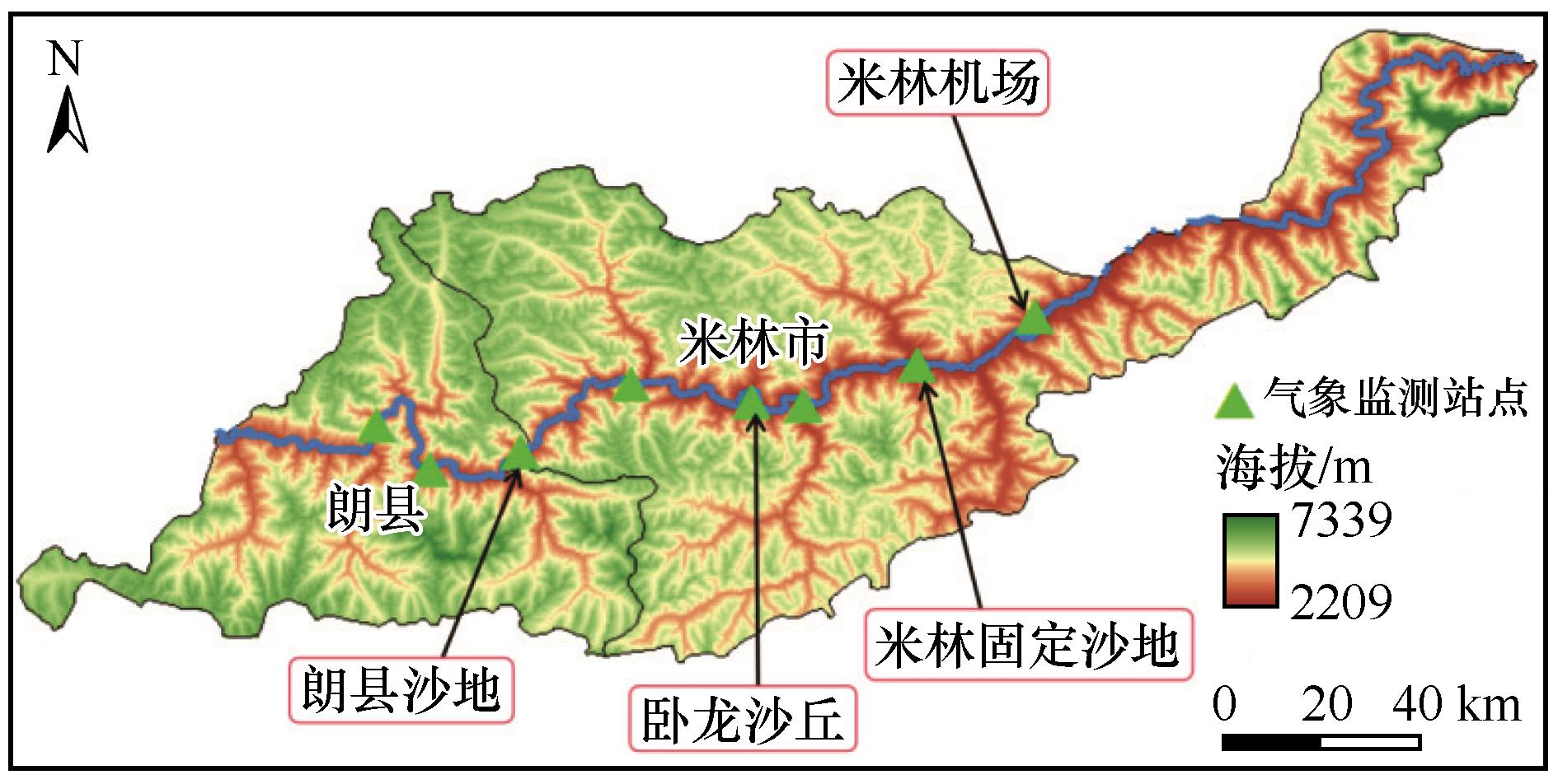
Fig.1 Schematic diagram of elevation and meteorological monitoring stations in the study area
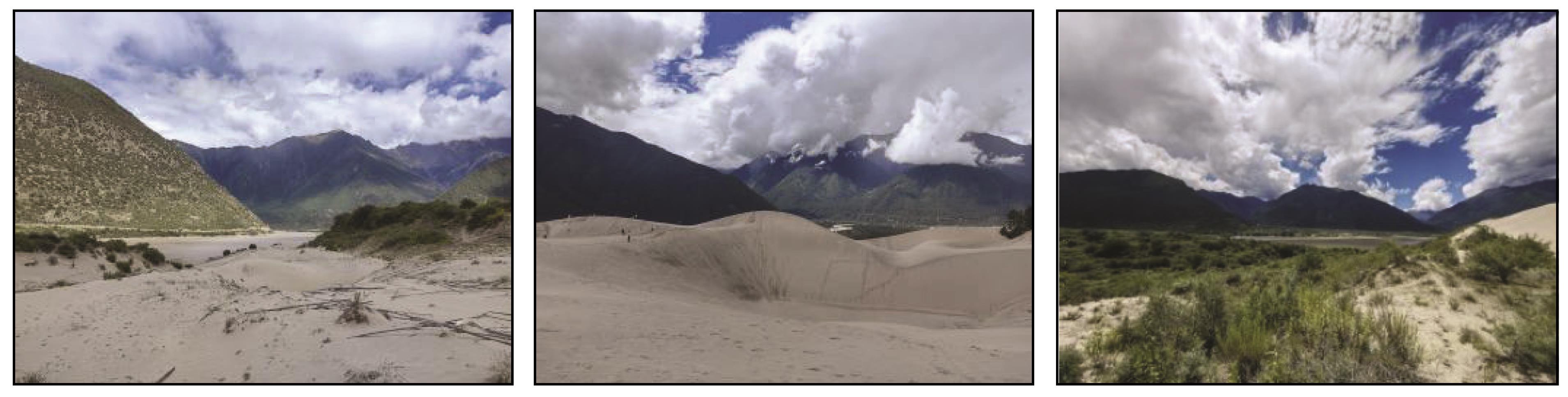
Fig.2 Typical sandy land in the middle reaches of the Yarlung Zangbo River
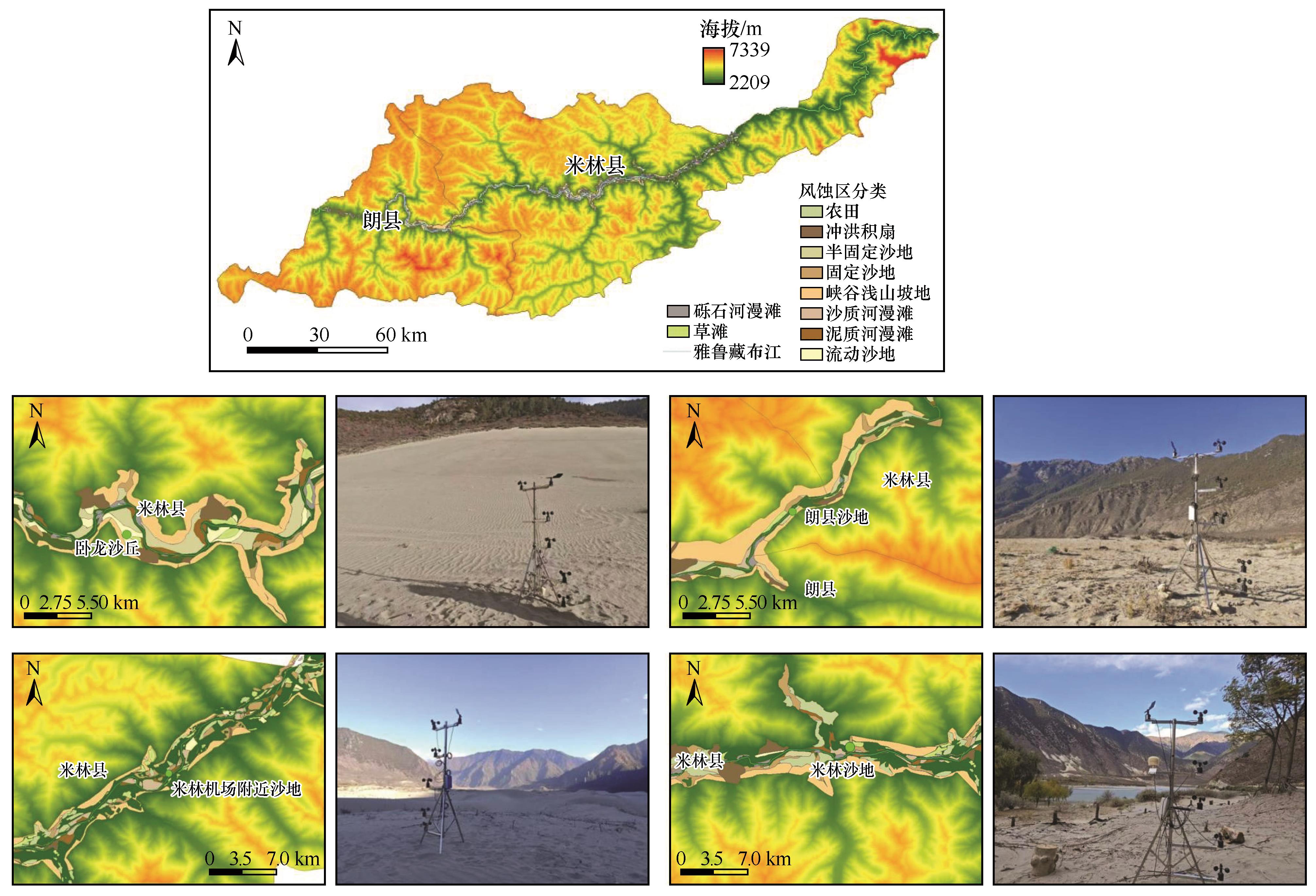
Fig.3 Valley land classification and meteorological information monitoring in the middle reaches of the Yarlung Zangbo River
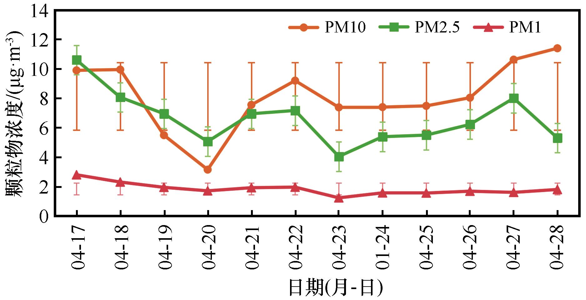
Fig.4 Daily average variation curve of particulate matter concentration (April 17-28, 2024)
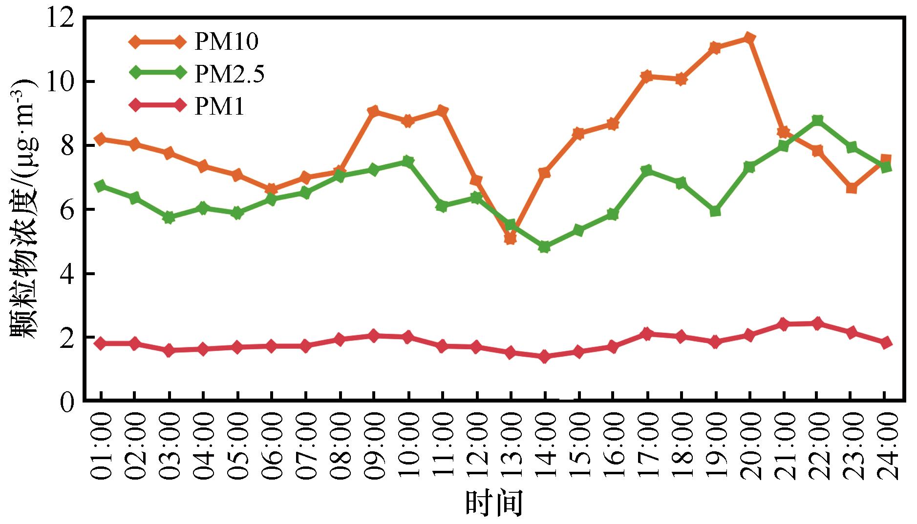
Fig.5 Variation curve of average particulate matter concentration by time period
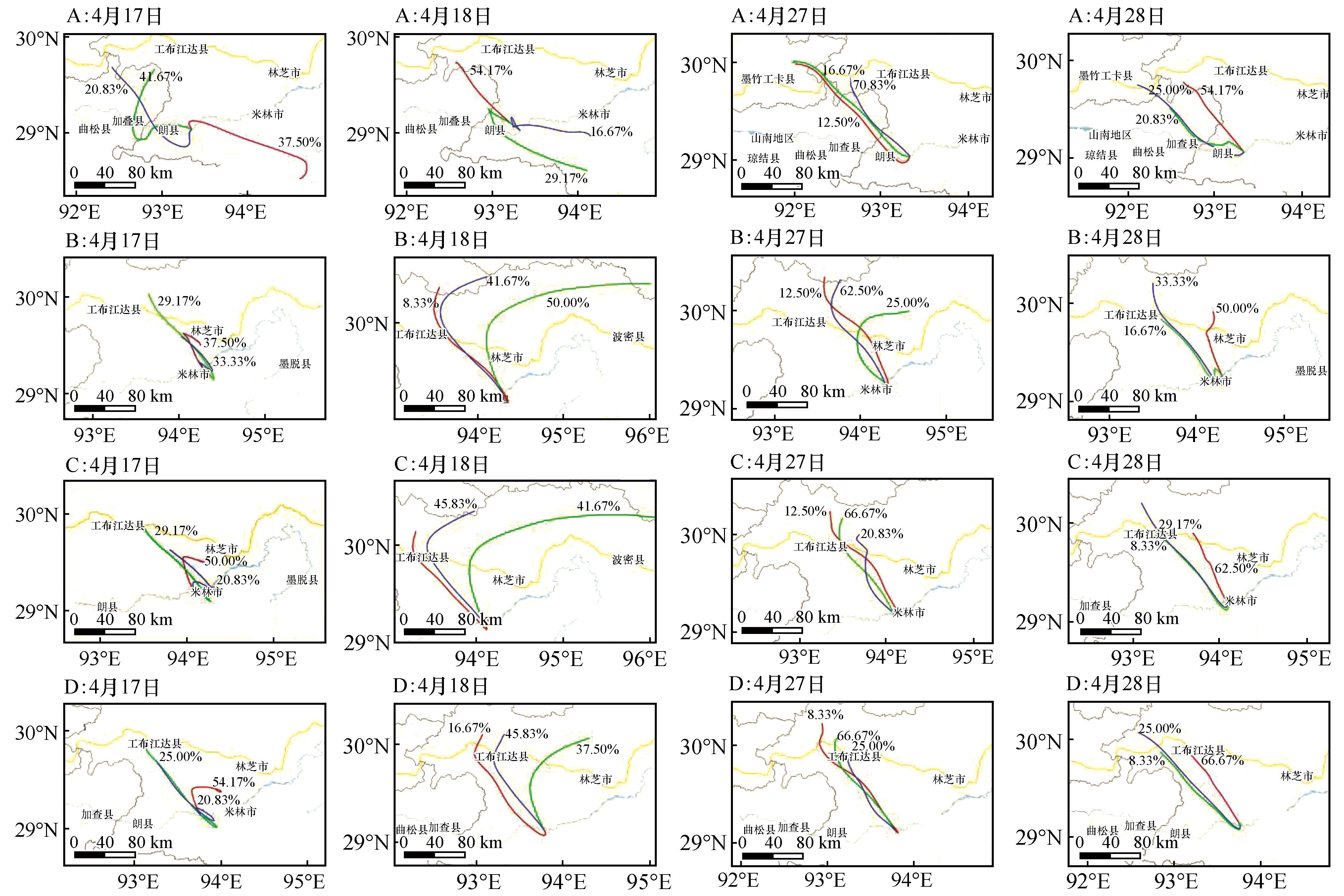
Fig.6 Dust transport pathways during the monitoring period at each study site
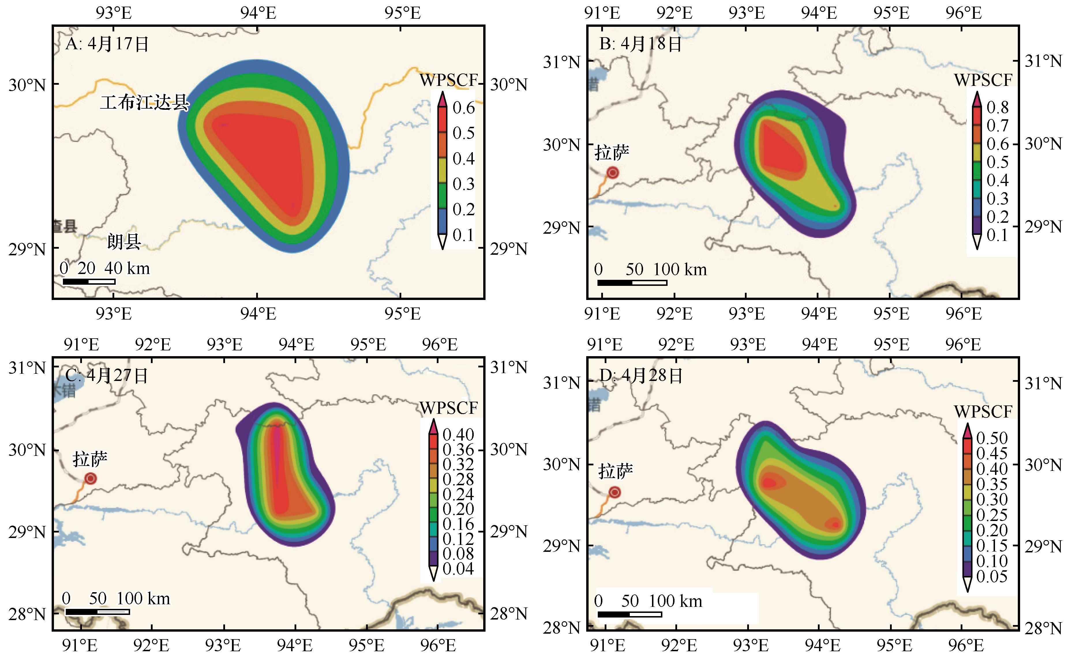
Fig.7 Potential source contribution function (pscf) and pollutant concentration dispersion at meteorological monitoring points
| [1] | 张令光,沈才生,黄艳丽,等.雅鲁藏布江流域输沙势空间特征[J].中国沙漠,2025,45(1):304-317. |
| [2] | IPCC.Climate Change 2021:The Physical Science Basis.Contribution of Working Group I to the Sixth Assessment Report of the Intergovernmental Panel on Climate Change[M].London,UK:Cambridge University Press.2021. |
| [3] | 拉珍,唐叔乙,坚参扎西,等.雅鲁藏布江中游沙尘天气频率及传输过程[J].中国沙漠,2023,43(4):10-16. |
| [4] | Huang J, Kang S, Zhang Q,et al.Linking atmospheric pollution to cryospheric change in the Third Pole region:current progress and future prospects[J].National Science Review,2020,7(9):1492-1503. |
| [5] | Liu Z, Liu T, Han Z,et al.Detection and monitoring of super sandstorm and its impacts on Arabian Sea:remote sensing approach[J].Arid Land Resources and Environment,2016,30(12):129-136. |
| [6] | Yoshida M, Kikuchi M, Nagao T M,et al.Himawari-8/AHI hourly aerosol optical depth retrieval over land using a time series method[J].Atmospheric Measurement Techniques,2022,15(2):433-451. |
| [7] | 陈瑞敏,张玉婷,韩冰,等.衡水市三类臭氧重污染事件特征及其潜在源区研究[J].环境生态学,2024,6(5):120-126. |
| [8] | Kaspari S, Skiles S M, Delaney I,et al.Accelerated glacier melt on Snow Dome,Mount Olympus,Washington,USA,due to deposition of Asian dust[J].The Cryosphere.2021,15(1):443-457. |
| [9] | 张正偲,张焱,马鹏飞,等.雅鲁藏布江中游风沙区典型下垫面空气动力学参数研究[J].干旱区研究,2022,39(4):997-1005. |
| [10] | Ma P F, Zhang Z C, Zhang Y, al et,Effect of meteorological conditions on-PM 10 concentrations in the middle reaches of the Yarlung Zangbo River,Tibet Plateau[J].Theoretical and Applied Climatology,2023,151(1/2):725-737. |
| [11] | Zhang Z C, Zhang Y, Ma P F,et al.Aeolian sediment transport rates in the middle reaches of the Yarlung Zangbo River,Tibet Plateau[J].Science of the Total Environment,2022,826:154-158. |
| [12] | Zhang X, Kang S, Zhang G, al et,Dust emission and transport over the Tibetan Plateau :a case study of the Yarlung Tsangpo Valley[J].Atmospheric Environment,2020,223:117-123. |
| [13] | Wang X, Huang J, Ji M, al et,Modeling the impact of dust-radiative forcing on the mountain-valley circulation over the Tibetan Plateau[J].Atmospheric Chemistry and Physics,2019,19(19):12767-12780. |
| [14] | Webb N P, Chappell A, Edwards B L,et al.Aeolian sediment transport following wildfire in sagebrush steppe[J].Journal of Arid Environments,2020,172:104-121. |
| [15] | 刘婷,贾晓鹏,陈定梅,等.雅鲁藏布江中游平坦流沙地表空气动力学特征[J].中国沙漠,2023,43(5):194-203. |
| [16] | Li C, Bosch C, Kang S,et al.Aeolian dust transport,cycle and influences in high-elevation cryosphere of the Tibetan Plateau region:recent progresses and future directions[J].Earth-Science Reviews,2018,190:60-77. |
| [17] | Jin Q, Wei J, Yang Z L,et al.Tibetan Plateau dust modulates the Indian summer monsoon rainfall[J].Geophysical Research Letters,2021,48(8):18-21. |
| [18] | Chen Z, Li G, Yang J.Sr-Nd isotopic evidence for modern aeolian dust sources in the western Loess Plateau[J].Geophysical Research Letters,2020,47(15):859-865. |
| [19] | 王薇,邬光剑,范丽行,等.2000-2020年雅鲁藏布江中部流域大气气溶胶时空变化及影响因素[J].环境科学,2024,45(12):7003-7011. |
| [20] | 张平平,李滨,高浩源,等.西藏林芝多雄河流域高位雪崩易发性评价[J].中国地质灾害与防治学报,2024,35(6):44-57. |
| [21] | 张核真,周刊社,多杰桑珠,等.1981-2016年雅鲁藏布江流域风沙日数时空变化特征分析[J].干旱区资源与环境,2018,32(12):131-136. |
| [22] | 王琰玮,王媛,张增凯,等.不同季节天津市PM2.5与O3潜在源区及传输路径分析[J].环境科学研究,2022,35(3):673-682. |
| [23] | 蔡敏,谷欣,赵正昱,等.2016-2021 年运城市区臭氧浓度特征及其与气象因素的关系[J].环境科学学报,2023,43(9):229-243 |
| [24] | 王蕾,杨震,刘笑,等.关中地区沙尘输送路径及潜在源区分析[J].干旱区资源与环境,2023,37(10):109-117 |
| [25] | 谢放尖,陆晓波,杨峰,等.2017年春夏期间南京地区臭氧污染输送影响及潜在源区[J].环境科学,2021,42(1):88-96. |
| [26] | 史忠林,张信宝,张润川.2021年“3·15”沙尘暴沙尘来源核素示踪研究[J].中国沙漠,2022,42(2):1-5. |
| [27] | 张昊,党晓宏,蒙仲举,等.乌珠穆沁沙地主要风沙环境特征及形成机制研究[J].干旱区研究,2023,40(10):1687-1697. |
| [28] | 伍永秋,王立辉,杜世松,等.青藏高原典型地区沉积物地球化学特征与矿物组成的粒度效应[J].冰川冻土,2022,44(4):1140-1149. |
| [29] | 康世昌,丛志远,王小萍,等.大气污染物跨境传输及其对青藏高原环境影响[J].科学通报,2019,64(27):2876-2884. |
| [30] | 黎凌翀,叶芝祥,周丽君,等.青藏高原牛粪燃烧PM2.5排放因子及组成特征[J].环境科学与技术,2023,46(12):187-194. |
| [31] | 缑倩倩,韩致文,杜鹤强,等.中国沙尘暴源区及其治理研究述评[J].中国沙漠,2012,32(6):1559-1564. |
| [32] | 关敏,张勇,李云,等.我国风云气象卫星发展现状与未来展望[J].地球科学进展,2025,40(2):138-154. |
| [33] | 刘玥,郭强,袁立敏,等.三种植物基固沙剂对风沙土水分入渗和蒸发的影响[J].干旱区研究,2025,4(9):1-12. |
| [34] | 苗运法,雷艳,赵永涛,等.亚洲内陆干旱区空气孢粉研究现状及展望[J].第四纪研究,2024,44(3):688-703. |
| [1] | Xuelin Wang, Jiangbo Chen, Hao Liu, Hang Gong, Hanzhuo Wang, Guodong Ding, Yuanyuan Zhao. Fractal dimension characteristics of soil particle size distribution and wind erosion resistance in the middle-lower reaches of the Yarlung Zangbo River wide valley [J]. Journal of Desert Research, 2026, 46(3): 330-340. |
| [2] | Hang Gong, Hao Liu, Songyan Chen, Guodong Ding. Soil quality evaluation of different site types in wind erosion area of wide valley in the middle and lower reaches of Yarlung Zangbo River Basin [J]. Journal of Desert Research, 2026, 46(2): 301-311. |
| [3] | Qingguo Zheng, Chunlai Zhang, Yajing Zhang, Xuesong Wang, Wenping Li, Fanrui Bu, Jiaqi Zhao, Xinran Cui, Zhishan Xia. Characteristics of dust emission from gobi surfaces [J]. Journal of Desert Research, 2025, 45(3): 152-161. |
| [4] | Lingguang Zhang, Caisheng Shen, Yanli Huang, Zaduo, Lazhen, Yan Zhang, Zhengcai Zhang. The spatial variations of sand drift potential in Yarlung Zangbo River Basin [J]. Journal of Desert Research, 2025, 45(1): 304-317. |
| [5] | Jiaqi Chu, Ping Yan, Zhizhu Su, Wenjie Yuan, Xiaoxu Wang, Xiao Zhang, Huagang Zhao. Morphological evolution and migration characteristics of a climbing dune in Mainling Great Valley section of Yarlung Zangbo River [J]. Journal of Desert Research, 2024, 44(6): 220-230. |
| [6] | Jiahui Cao, Siyu Chen, Chao Zhang, Lulu Lian, Dan Zhao, Shikang Du. External contribution of the Tibetan Plateau dust [J]. Journal of Desert Research, 2024, 44(2): 57-65. |
| [7] | Lazhen, Shuyi Tang, Zhaxi Jiancan, Cizhen, Pengfei Ma. Dust weather diurnal variation and transmission process in the middle reaches of the Yarlung Zangbo River [J]. Journal of Desert Research, 2023, 43(4): 10-16. |
| [8] | Siyu Chen, Yawen Guan, Dan Zhao, Gaotong Lou, Yu Chen. Influence of dust aerosol on land surface diurnal temperature range over East Asia Simulated with the WRF-Chem model [J]. Journal of Desert Research, 2022, 42(3): 127-138. |
| [9] | Luosangqujia, Yan Zhang, Pengfei Ma, Zaduo, Geduo, Zhengcai Zhang. Study on the sand transport quantities on the different landscapes in the middle area of Yarlung Zangbo River [J]. Journal of Desert Research, 2022, 42(2): 6-13. |
| [10] | Pengfei Ma, Qunpei Lunzhu, Yan Zhang, Nima Ciren, Junfeng Lu, Aimin Liang, Zhengcai Zhang. Sand supplement characteristics indicated by the area of river inland, flood plain in the riverbed of the Yarlung Zangbo River [J]. Journal of Desert Research, 2021, 41(3): 25-33. |
| [11] | Yan Zhang, Pengfei Ma, Lin Zeng, Aimin Liang, Zhengcai Zhang. Study on silt and clay provenance in the Yarlung Zangbo River middle reaches using sediment physicochemical characteristics [J]. Journal of Desert Research, 2021, 41(3): 92-100. |
| [12] | Pengfei Ma, Zhengcai Zhang, Qunpei Lunzhu, Jiajia Gao, Rui Dai, Wang Ci, Kaijia Pan. Analysis on the sand transport wind power conditions and suggestions on the sand disaster preventions in the middle reaches of Yarlung Zangbo River, China [J]. Journal of Desert Research, 2021, 41(1): 10-18. |
| [13] | Liu Hui, Li Xiaoying, Xia Cuizhen, Yao Zhengyi. Formation of dunes in Gyaca-Mainling section of Yarlung Zangbo River Valley of China [J]. Journal of Desert Research, 2020, 40(3): 16-26. |
| [14] | Hua Cong, Liu Chao, Zhang Bihui. Comparative Analysis of Transport Characteristics of Two Dust Events Affecting Beijing [J]. Journal of Desert Research, 2019, 39(6): 99-107. |
| [15] | Liu Hui, Li Xiaoying, Yao Zhengyi. Rainfall Erosivity in Yarlung Zangbo River Basin during 1961-2015 [J]. Journal of Desert Research, 2019, 39(2): 166-176. |
| Viewed | ||||||
|
Full text |
|
|||||
|
Abstract |
|
|||||
©2018Journal of Desert Research
Tel:0931-8267545
Email:caiedit@lzb.ac.cn;desert@lzb.ac.cn
Support:Magtech