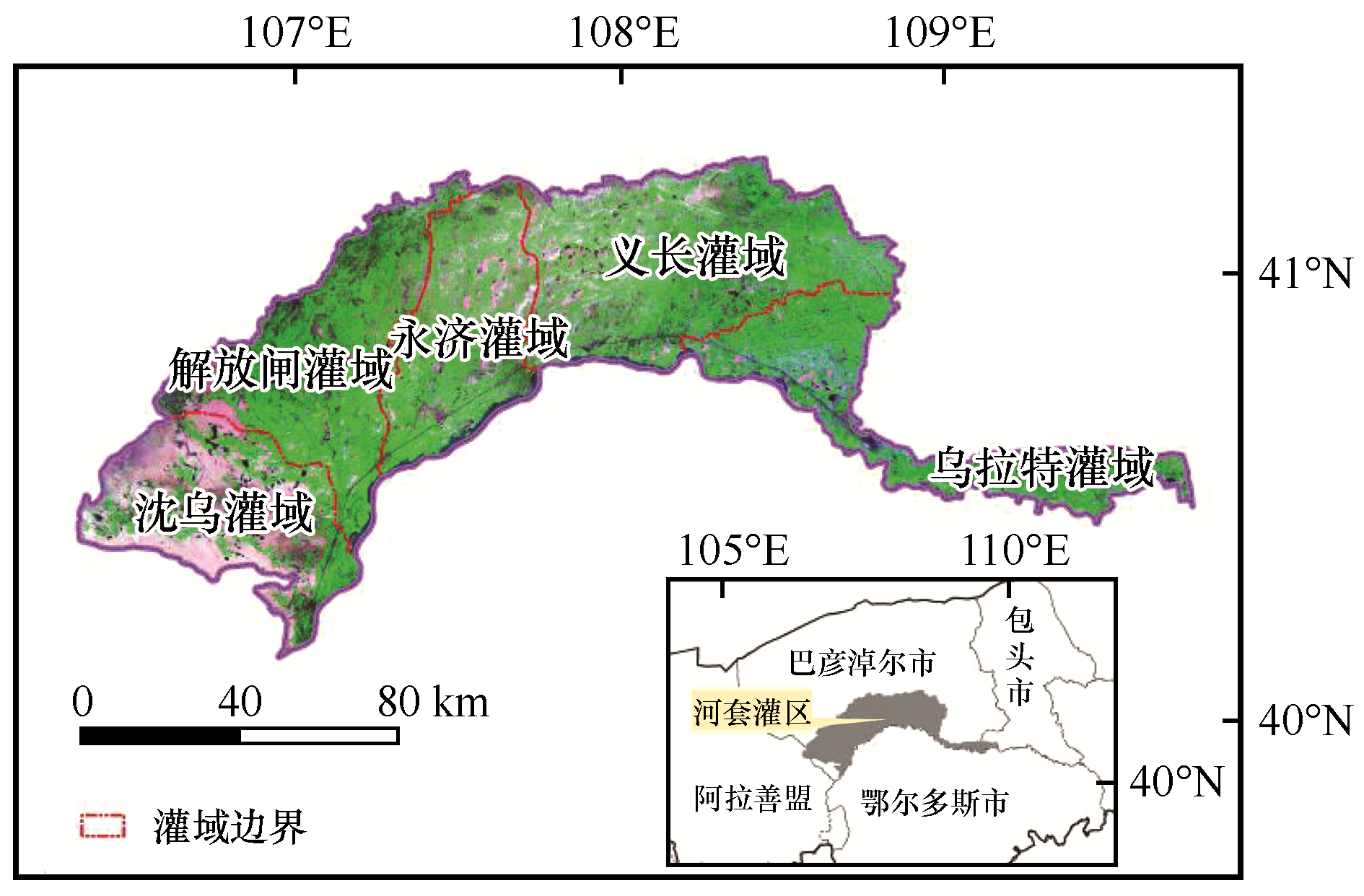
| 1 |
王新源,刘世增,陈翔舜,等.河西走廊绿洲面积动态及其驱动因素[J].中国沙漠,2019,39(4):212-219.
|
| 2 |
吕新,杨磊,张凤华,等.荒漠绿洲区农业特征及其可持续发展策略[J].中国沙漠,2005,25(4):599-603.
|
| 3 |
张琪,罗格平,李龙辉,等.基于土地利用/覆被变化表征的现代绿洲演变过程:以天山北坡三工河流域为例[J].地理学报,2016,71(7):1157-1171.
|
| 4 |
Zhang X F,Zhang L H,He C S,et al.Quantifying the impacts of land use/land cover change on groundwater depletion in Northwestern China:a case study of the Dunhuang oasis[J].Agricultural Water Management,2014,146:270-279.
|
| 5 |
张健康,程彦培,张发旺,等.基于多时相遥感影像的作物种植信息提取[J].农业工程学报,2012,28(2):134-141.
|
| 6 |
康文平,刘树林,段翰晨.基于MODIS时间序列数据的沙漠化遥感监测及沙漠化土地图谱分析:以内蒙古中西部地区为例[J].中国沙漠,2016,36(2):307-318.
|
| 7 |
常茜,鹿化煜,吕娜娜,等.1992—2015年中国沙漠面积变化的遥感监测与气候影响分析[J].中国沙漠,2020,40(1):57-63.
|
| 8 |
Zhang H,Chen H,Zhou G.The model of wheat yield forecast based on MODIS-NDVI:a case study of Xinxiang[C]//ISPRS Amnals of Photogrammetry,Remote Sensing and Spatial Information Sciences,2012,I-7:25-28.
|
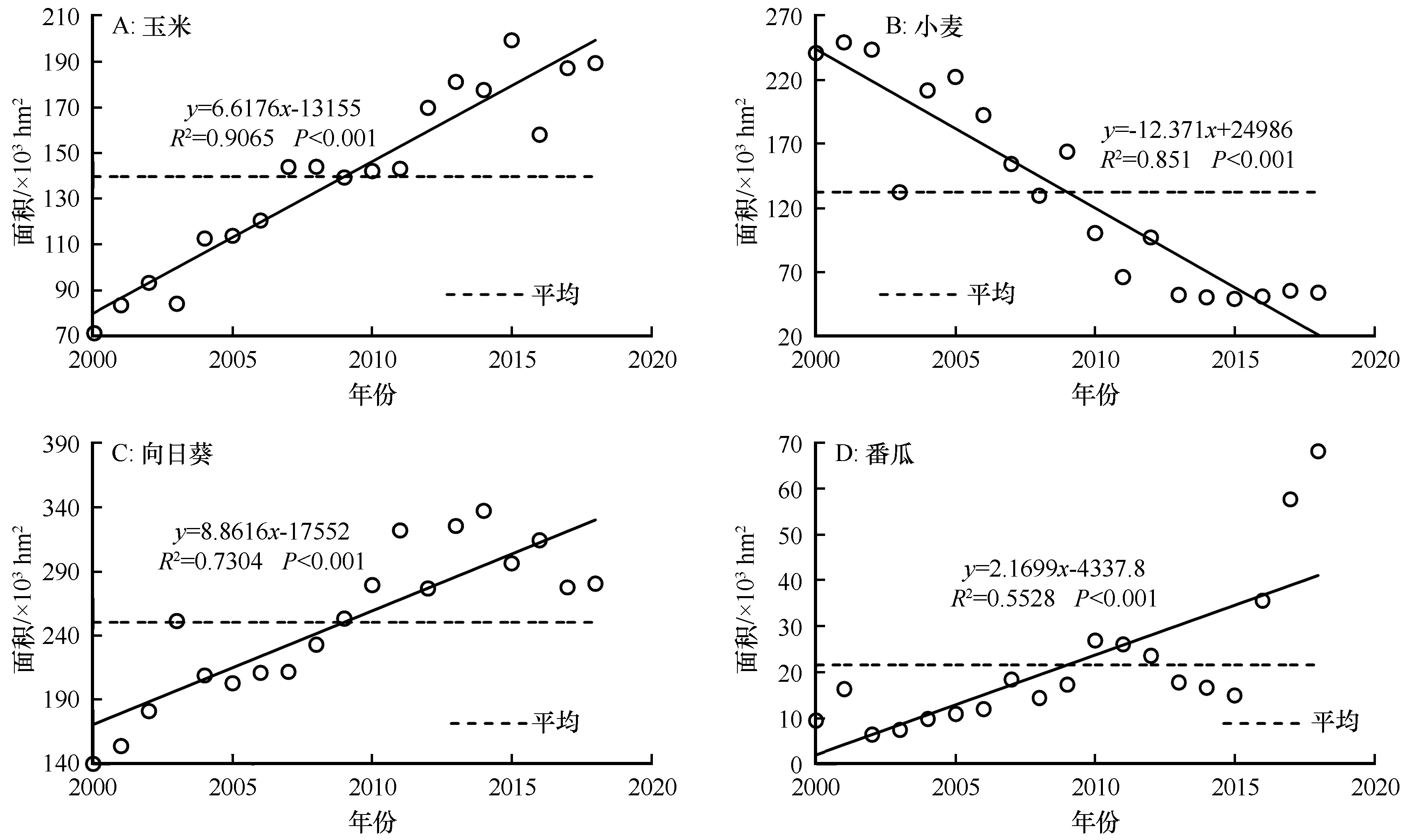
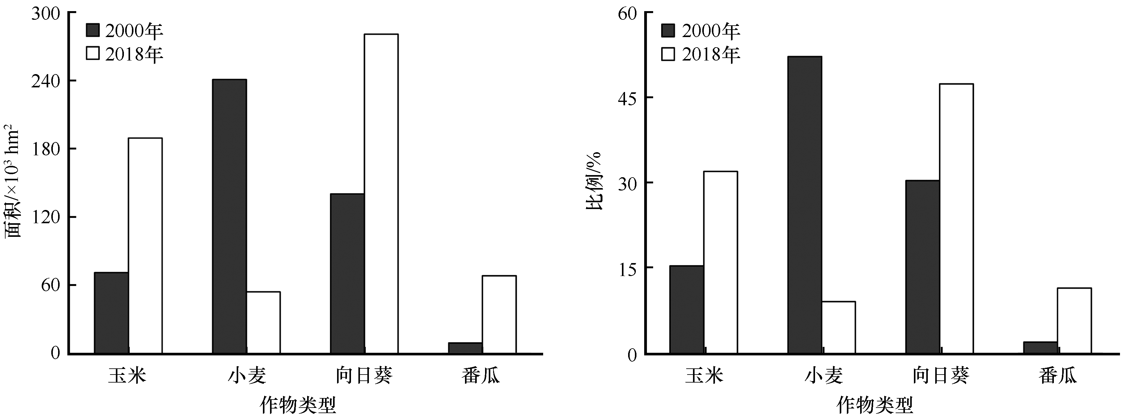
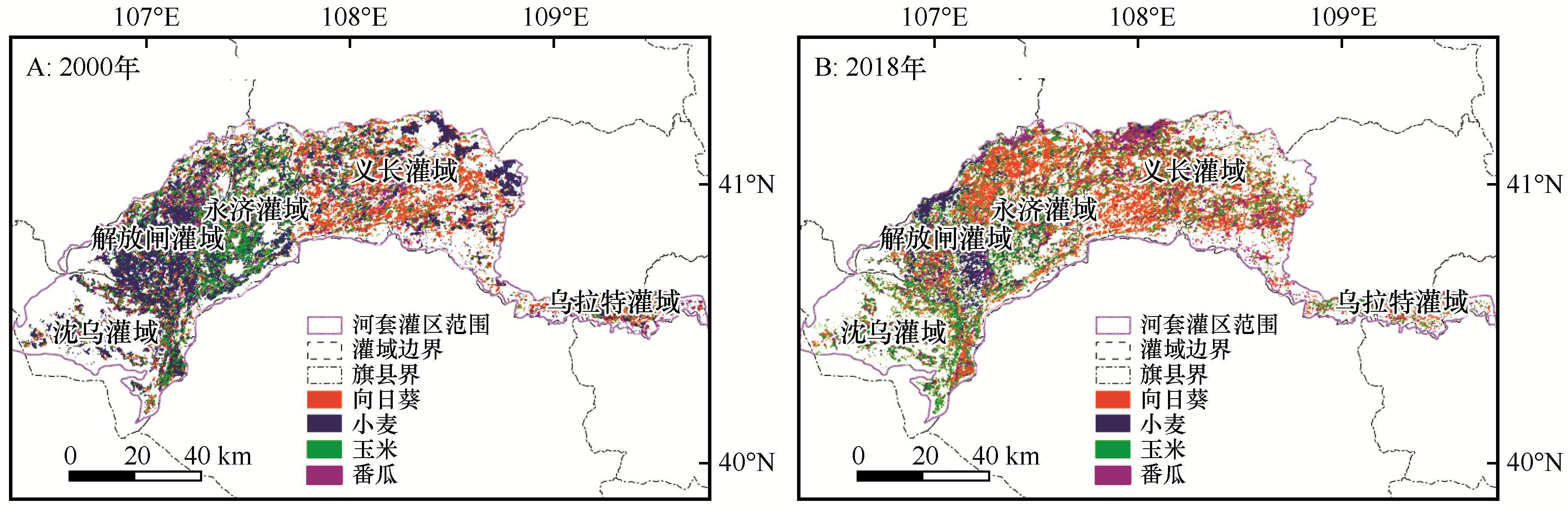
| 9 |
Wang S X,Wu B,Yang P N.Assessing the changes in land use and ecosystem services in an oasis agricultural region of Yanqi Basin,Northwest China[J].Environmental Monitoring & Assessment,2014,186(12):8343-8357.
|
| 10 |
张敏,曹春香,陈伟.基于MODIS NDVI数据的广西植被覆盖时空变化遥感诊断[J].林业科学,2019,55(10):27-37.
|
| 11 |
李颖,陈秀万,段红伟,等.多源多时相遥感数据在冬小麦识别中的应用研究[J].地理与地理信息科学,2010,26(4):47-49.
|
| 12 |
李晓东,姜琦刚.基于多时相遥感数据的农田分类提取[J].农业工程学报,2015,31(7):145-150.
|
| 13 |
Tornos L,Huesca M,Dominguez J A,et al.Assessment of MODIS spectral indices for determining rice paddy agricultural practices and hydroperiod[J].ISPRS Journal of Photogrammetry and Remote Sensing,2015,101:110-124.
|
| 14 |
袁玉娟,尹云鹤,戴尔阜,等.基于阈值分割的黑龙江省森林类型遥感识别[J].地理科学进展,2016,35(5):655-663.
|
| 15 |
竞霞,王锦地,王纪华,等.基于分区和多时相遥感数据的山区植被分类研究[J].遥感技术与应用,2008(4):360,394-397.
|
| 16 |
宋茜,周清波,吴文斌,等.农作物遥感识别中的多源数据融合研究进展[J].中国农业科学,2015,48(6):1122-1135.
|
| 17 |
王琳,景元书,杨沈斌.基于多时相遥感数据提取水稻种植面积的研究[J].中国农业资源与区划,2013,34(2):21-26.
|
| 18 |
汪小钦,邱鹏勋,李娅丽,等.基于时序Landsat遥感数据的新疆开孔河流域农作物类型识别[J].农业工程学报,2019,35(16):180-188.
|
| 19 |
Sharma A,Liu X W,Yang X J.Land cover classification from multi-temporal,multi-spectral remotely sensed imagery using patch-based recurrent neural networks[J].Neural Networks,2018,105:346-355.
|
| 20 |
张谱,管文轲,刘洪霞,等.新疆迪那河流域轮台人工绿洲耕地时空变化特征分析[J].农业机械学报,2019,50(5):291-299.
|
| 21 |
张军峰,孟凡浩,包安明,等.新疆孔雀河流域人工绿洲近40年土地利用/覆被变化[J].中国沙漠,2018,38(3):664-672.
|
| 22 |
刁维杰,赵勇,翟家齐,等.1987—2017年民勤绿洲面积时空演变规律及驱动因素解析[J].灌溉排水学报,2019,38(10):106-113.
|
| 23 |
王让会,孙洪波,赵振勇.新疆且末绿洲土地利用变化机制与驱动力分析[J].干旱区地理,2005(6):849-855.
|
| 24 |
任东阳,徐旭,黄冠华.河套灌区典型灌排单元农田耗水机制研究[J].农业工程学报,2019,35(1):98-105.
|
| 25 |
陶健宇,杨劲松,姚荣江,等.河套灌区土壤盐分对化肥氮素转化过程的影响研究[J].土壤,2020,52(4):802-810.
|
| 26 |
王志超,李仙岳,史海滨,等.覆膜年限及灌水方法对河套灌区农膜残留的影响[J].农业工程学报,2017,33(14):159-165.
|
| 27 |
张娜,张栋良,屈忠义,等.不同尺度下内蒙古河套灌区有机质空间变异[J].生态学杂志,2016,35(3):630-640.
|
| 28 |
徐岩岩.基于MODIS数据提取东北地区水稻物候时空变化特征[D].北京:中国气象科学研究院,2012.
|
| 29 |
温一博,范文义.多时相遥感数据森林类型识别技术研究[J].森林工程,2013,29(2):14-20.
|
| 30 |
Adler J,Parmryd I.Quantifying colocalization by correlation:the Pearson correlation coefficient is superior to the Mander's overlap coefficient[J].Cytometry.Part A:the Journal of the International Society for Analytical Cytology,2010,77(8):733-742.
|
| 31 |
王理想,蔡明玉,白雪莲,等.乌兰布和沙漠东南缘湖泊群消涨与驱动因素[J].中国沙漠,2020,40(2):59-67.
|
| 32 |
夏鑫鑫,朱磊,杨爱民,等.基于MODS的生态系统服务正负价值测算:以新疆玛纳斯河流域为例[J].生态学报,2020,40(12):1-14.
|
| 33 |
张浚茂,臧传富.东南诸河流域1990—2015年土地利用时空变化特征及驱动机制[J].生态学报,2019,39(24):9339-9350.
|
| 34 |
高啸峰,王树德,宫阿都,等.基于主成分分析法的土地利用/覆被变化驱动力研究[J].地理与地理信息科学,2009,25(1):36-39.
|
| 35 |
傅家仪,臧传富,吴铭婉.1990—2015年海河流域土地利用时空变化特征及驱动机制研究[J].中国农业资源与区划,2020,41(5):131-139.
|
 ), 乔荣荣2, 季树新2, 白雪莲2, 王理想2, 常学礼2(
 甘公网安备 62010202000688号