| 1 |
Lancaster N.Geomorphology of Desert Dunes[M].London,UK:Routledge,1995.
|
| 2 |
吴正.风沙地貌与治沙工程学[M].北京:科学出版社,2003.
|
| 3 |
Pye K, Tsoar H.Aeolian Sand and Sand Dunes[M].Berlin,Germany:Springer Science & Business Media,2009.
|
| 4 |
Bristow C S, Bailey S D, Lancaster N.The sedimentary structure of linear sand dunes[J].Nature,2000,406(6791):56-59.
|
| 5 |
Bristow C S, Lancaster N, Duller G A T.Combining ground penetrating radar surveys and optical dating to determine dune migration in Namibia[J].Journal of the geological society,2005,162(2):315-321.
|
| 6 |
Lucas A, Narteau C, Rodriguez S,et al.Sediment flux from the morphodynamics of elongating linear dunes[J].Geology,2015,43(11):1027-1030.
|
| 7 |
Craddock R A, Tooth S, Zimbelman J R,et al.Temporal observations of a linear sand dune in the Simpson Desert,central Australia:testing models for dune formation on planetary surfaces[J].The Journal of Geophysical Research Planets,2015,120(10):1736-1750.
|
| 8 |
李继彦,董治宝.线形沙丘研究进展评述与展望[J].中国沙漠,2018,38(6):1153-1165.
|
| 9 |
Bagnold R A.The Physics of Blow n Sand and Desert Dunes[M].London,UK:Chapman & Hall,1941.
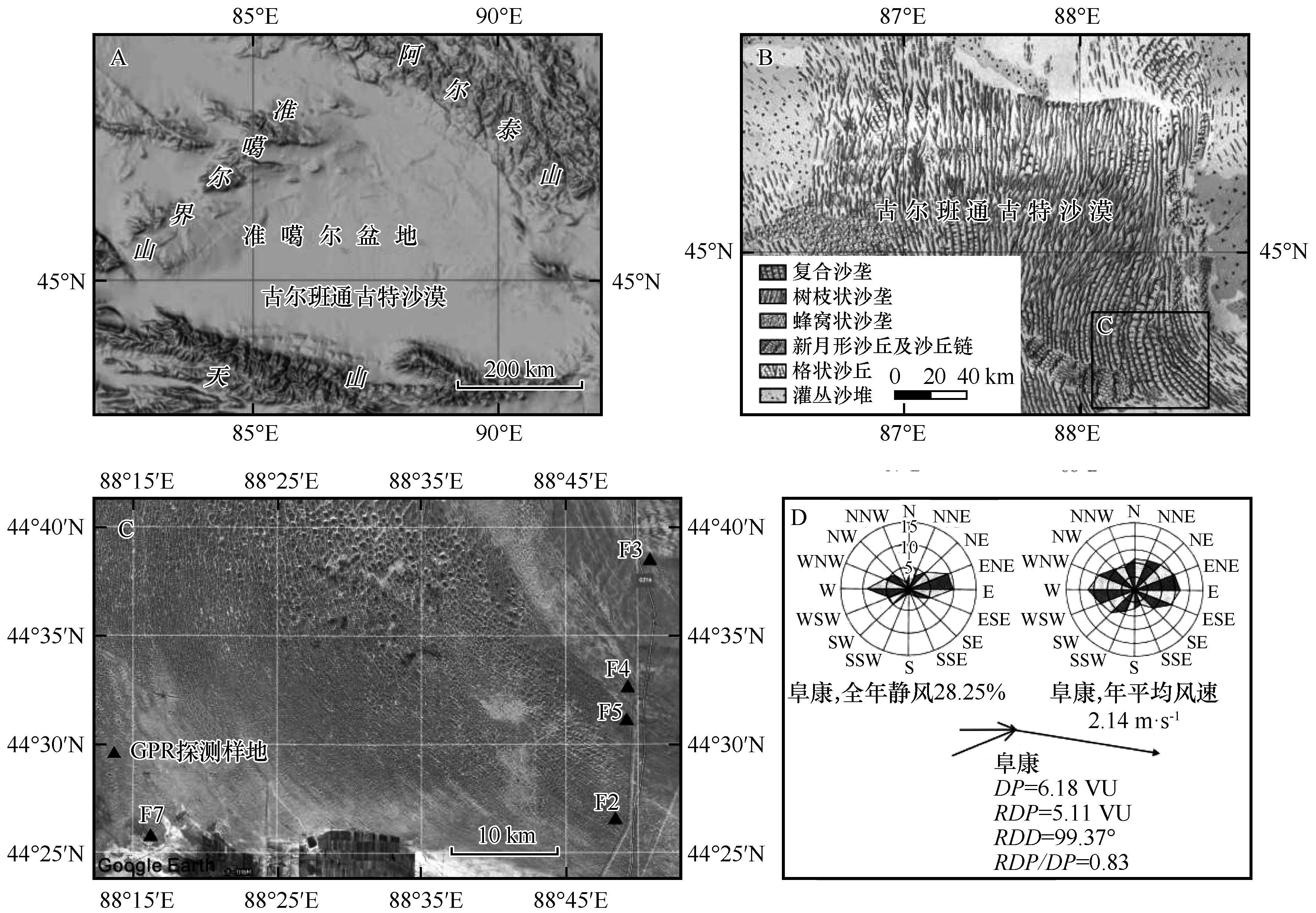
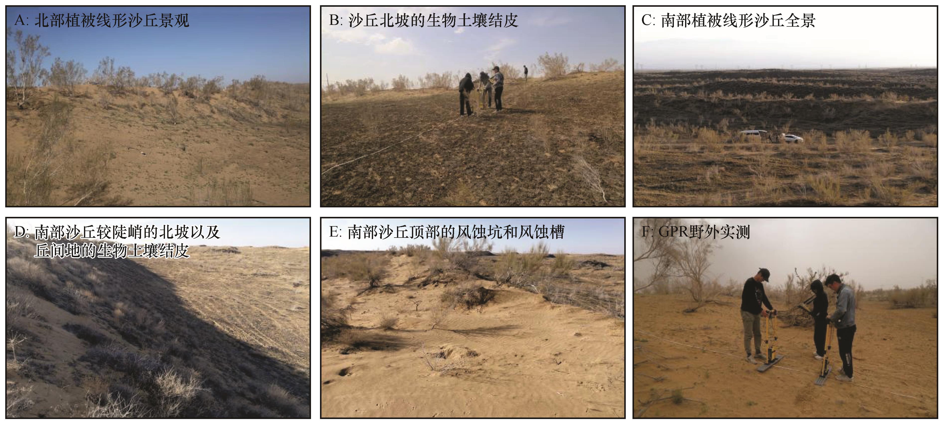
|
| 10 |
McKee E D, Tibbitts G C.Primary structures of a seif dune and associated deposits in Libya[J].Journal of Sedimentary Research,1964,34(1):5-17.
|
| 11 |
钱征宇,刘守勤.线形沙丘的风沙沉积特征与内部构造[J].中国沙漠,1994,14(3):25-30.
|
| 12 |
Tsoar H, Blumberg D G, Wenkart R.Formation and Geomorphology of the North-Western Negev Sand Dunes[M].Berlin,Germany:Springer,2008,200:25-48.
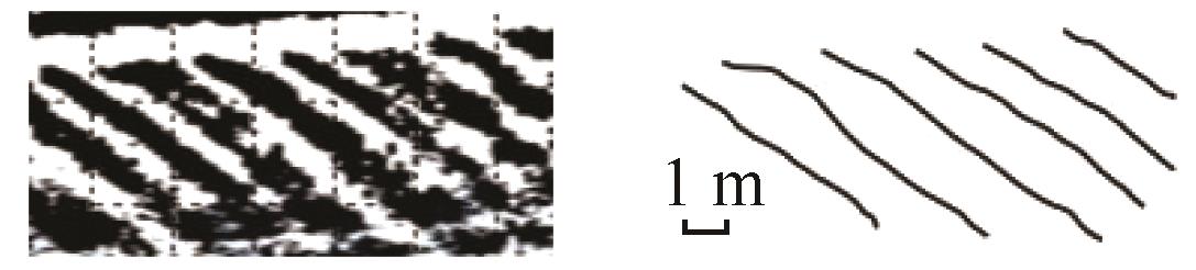
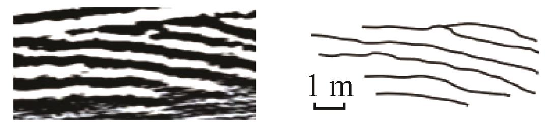
|
| 13 |
Rubin D M, Hunter R E.Why deposits of longitudinal dunes are rarely recognized in the geologic record[J].Sedimentology,1985,32(1):147-157.
|
| 14 |
Bristow C S, Duller G A T, Lancaster N.Age and dynamics of linear dunes in the Namib Desert[J].Geology,2007,35(6):555-558.
|
| 15 |
Zhou J X, Zhu Y, Yuan C Q.Origin and lateral migration of linear dunes in the Qaidam Basin of NW China revealed by dune sediments,internal structures,and optically stimulated luminescence ages,with implications for linear dunes on Titan[J].Geological Society of America Bulletin,2012,124(7/8):1147-1154.
|
| 16 |
Yu L P, Dong Z B, Lai Z P,et al.Origin and lateral migration of linear dunes in the Qaidam Basin of NW China revealed by dune sediments,internal structures,and optically stimulated luminescence ages,with implications for linear dunes on Titan:comment and discussion[J].Geological Society of America Bulletin,2015,127(1/2):316-320.
|
| 17 |
Tsoar H, Muller J T.The role of vegetation in the formation of linear sand dunes[M]//Aeolian Geomorphology.London,UK:Routledge,1986:75-96.
|
| 18 |
Wopfner H, Twidale C R.Formation and age of desert dunes in the Lake Eyre Depocentres in central Australia[J].Geology Rund,1988,77(3):815-834.
|
| 19 |
Bristow C S, Jones B G, Nanson G C,et al.GPR surveys of vegetated linear dune stratigraphy in central Australia:evidence for linear dune extension with vertical and lateral accretion[R]//Special Paper of the Geological Society of America.2007:19-33.
|
| 20 |
Roskin J, Tsoar H, Porat N,et al.Palaeoclimate interpretations of Late Pleistocene vegetated linear dune mobilization episodes:evidence from the northwestern Negev dunefield,Israel[J].Quaternary Science Reviews,2011,30(23-24):3364-3380.
|
| 21 |
Roskin J, Blumberg D G, Katra I,et al.Last millennium development and dynamics of vegetated linear dunes inferred from ground‐penetrating radar and optically stimulated luminescence ages[J].Sedimentology,2014,61(5):1240-1260.
|
| 22 |
Hesse P.Sticky dunes in a wet desert:formation,stabilisation and modification of the Australian desert dunefields[J].Geomorphology,2011,134(3/4):309-325.
|
| 23 |
Fisher A, Hesse P P.The response of vegetation cover and dune activity to rainfall,drought and fire observed by multi-temporal satellite imagery[J].Earth Surface Processes and Landforms,2019,44(15):2957-2967.
|
| 24 |
朱震达.中国沙漠概论[M].北京:科学出版社,1980.
|
| 25 |
吴正.中国沙漠及其治理[M].北京:科学出版社,2009.
|
| 26 |
王雪芹,雷加强.古尔班通古特沙漠半固定沙垄面的蚀积特征[J].干旱区研究,1998,15(1):35-39.
|
| 27 |
王雪芹,李丙文,张元明.古尔班通古特沙漠沙垄表面的稳定性与顶部流动带的形成[J].中国沙漠,2003,23(2):126-131.
|
| 28 |
王雪芹,王涛,蒋进,等.古尔班通古特沙漠南部沙面稳定性研究[J].中国科学D辑:地球科学,2004,34(8):763-768.
|
| 29 |
郭洪旭,王雪芹,盖世广,等.古尔班通古特沙漠腹地半固定沙垄顶部风沙运动规律[J].干旱区地理,2010,33(6):954-961.
|
| 30 |
吴正.准噶尔盆地沙漠地貌发育的基本特征[C]//全国地理学术会议论文选集(地貌).北京:科学出版社,1962:196-220.
|
| 31 |
中国科学院新疆综合考察队.新疆地貌[M].北京:科学出版社,1978.
|
| 32 |
Li S H, Fan A.OSL chronology of sand deposits and climate change of last 18 ka in Gurbantunggut Desert,northwest China[J].Journal of Quaternary Science,2011,26(8):813-818.
|
| 33 |
季方,叶玮,魏文寿.古尔班通古特沙漠固定与半固定沙丘成因初探[J].干旱区地理,2000(1):32-36.
|
| 34 |
钱亦兵,吴兆宁,等.古尔班通古特沙漠环境研究[M].北京:科学出版社,2010.
|
| 35 |
俞祁浩,屈建军,郑本兴,等.探地雷达在沙漠研究中的应用[J].中国沙漠,2004,24(3):371-375.
|
| 36 |
李孝泽,王振亭,陈发虎,等.巴丹吉林沙漠横向沙山沉积GPR雷达探测研究[J].第四纪研究,2009,29(4):797-805.
|
| 37 |
Neal A.Ground-penetrating radar and its use in sedimentology:principles,problems and progress[J].Earth Science Reviews,2004,66(3/4):261-330.
|
| 38 |
Bristow C.Ground penetrating radar in aeolian dune sands[J].Ground Penetrating Radar Theory and Applications,2009,271:273-297.
|
| 39 |
Fu T, Wu Y, Tan L,et al.Imaging the structure and reconstructing the development of a barchan dune using ground-penetrating radar[J].Geomorphology,2019,341:192-202.
|
| 40 |
Medina P Z, Limarino C, Bonomo N,et al.Using Ground penetrating radar and attribute analysis for identifying depositional units in a fluvial-aeolian interaction environment:the Guandacol Valley,northwest Argentina[J].Journal of South American Earth Sciences,2020,98:102467.
|
| 41 |
Tsoar H.Linear dunes-forms and formation[J].Progress in Physical Geography,1989,13(4):507-528.
|
| 42 |
Hesp P A.The formation of shadow dunes[J].Journal of Sedimentary Research,1981,51(1):101-112.
|
| 43 |
Ranwell D S.Ecology of Salt Marshes and Sand Dunes[M].London,UK:Chapman and Hall,1972.
|
| 44 |
Clemmensen L B.Storm-generated eolian sand shadows and their sedimentary structures,Vejers Strand,Denmark[J].Journal of Sedimentary Petrology,1986,56(4):520-527.
|
| 45 |
Suter-Burri K, Gromke C, Leonard K C,et al.Spatial patterns of aeolian sediment deposition in vegetation canopies:observations from wind tunnel experiments using colored sand[J].Aeolian Research,2013,8(2):65-73.
|
| 46 |
Yizhaq H, Ashkenazy Y, Tsoar H.Sand dune dynamics and climate change:a modeling approach[J].Journal of Geophysical Research Earth Surface,2009,114:1-11.
|
| 47 |
Zhao Y C, Gao X, Lei J Q,et al.Nebkha alignments and their implications for shadow dune elongation under unimodal wind regime[J].Geomorphology,2020,365:1-12.
|
| 48 |
秦艳芳,陈曦,周可法,等.利用探地雷达观测分析早春融雪前后沙丘表层土壤含水量的时空分布[J].冰川冻土,2012,34(3):690-697.
|
 ), 李志忠1,2,3(
 甘公网安备 62010202000688号