| 1 |
刘东生.黄土与环境[M].北京:科学出版社,1985.
|
| 2 |
Pye K.The nature,origin and accumulation of loess[J].Quaternary Science Reviews,1995,14:653-667.
|
| 3 |
李秉成,孙建中.中国黄土与环境[M].西安:陕西科学技术出版社,2005.
|
| 4 |
Li Y R, Shi W H, Aydin A,et al.Loess genesis and worldwide distribution[J].Earth-Science Reviews,2020,201:102947.
|
| 5 |
Fan M, Feng R, Geissman J W,et al.Late Paleogene emergence of a North American loess plateau[J].Geology,2020,48:273-277.
|
| 6 |
孙继敏.黄土沉积与地球圈层相互作用[J].第四纪研究,2020,40(1):1-7.
|
| 7 |
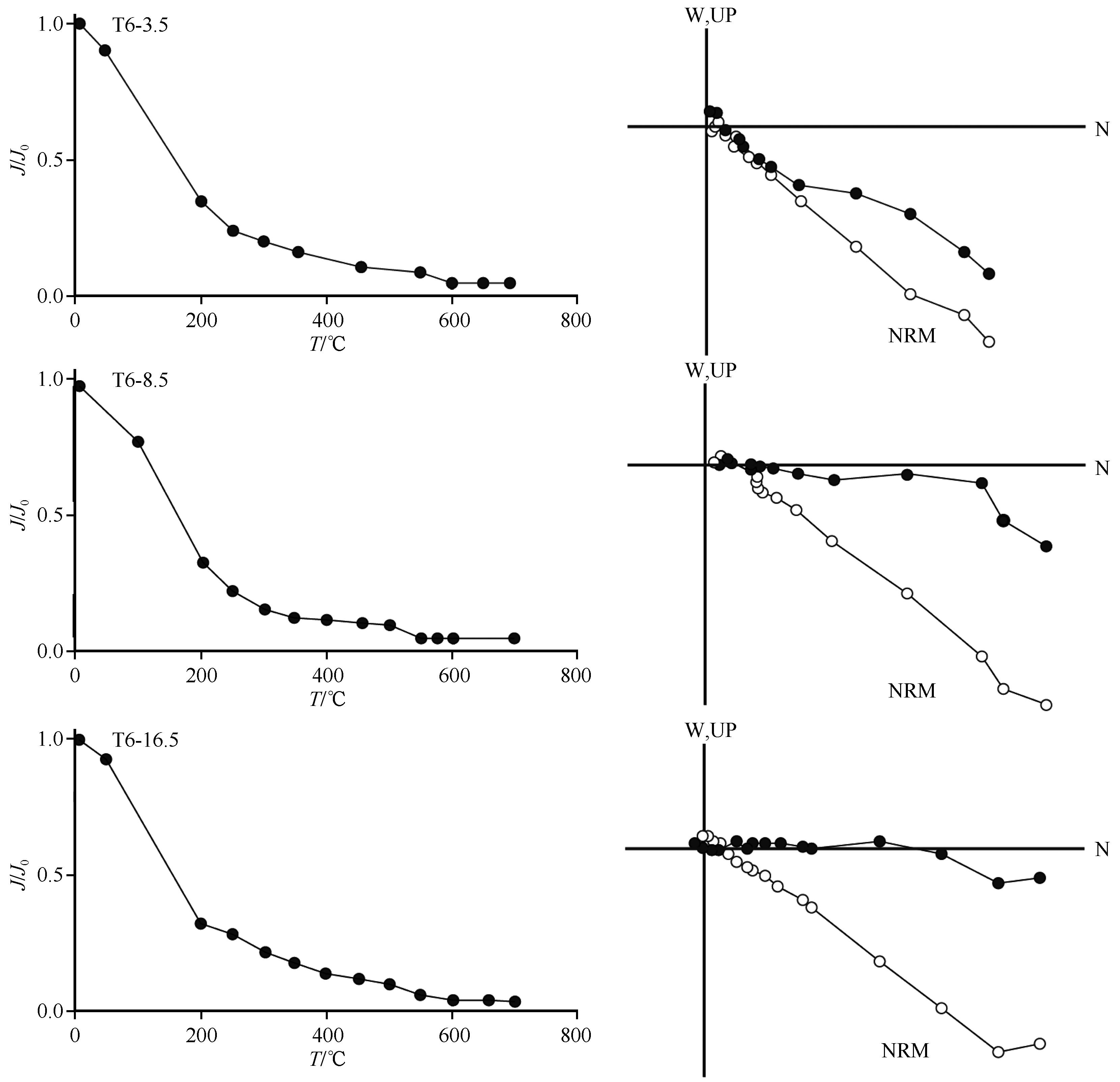
Heller F, Liu T S.Magnetostratigraphical dating of loess deposits in China[J].Nature,1982,300:431-433.
|
| 8 |
Burbank D W, Li J J.Age and palaeoclimatic significance of the loess of Lanzhou,north China[J].Nature,1985,316:429-431.
|
| 9 |
Kukla G J, Heller F, Liu X M,et al.Pleistocene climates in China dating by magnetic susceptibility[J].Geology,1988,16:811-814.
|
| 10 |
An Z S, Kukla G J, Porter S C,et al.Magnetic susceptibility evidence of monsoon variation on the Loess Plateau of central China during the last 130,000 years[J].Quaternary Research,1991,36:29-36.
|
| 11 |
鹿化煜,安芷生.洛川黄土地层定年的一个模式及其初步应用[J].沉积学报,1997,15(3):150-152.
|
| 12 |
Sun J M.Source regions and formation of the loess sediments on the high mountain regions of northwestern China[J].Quaternary Research,2002,58(3):341-351.
|
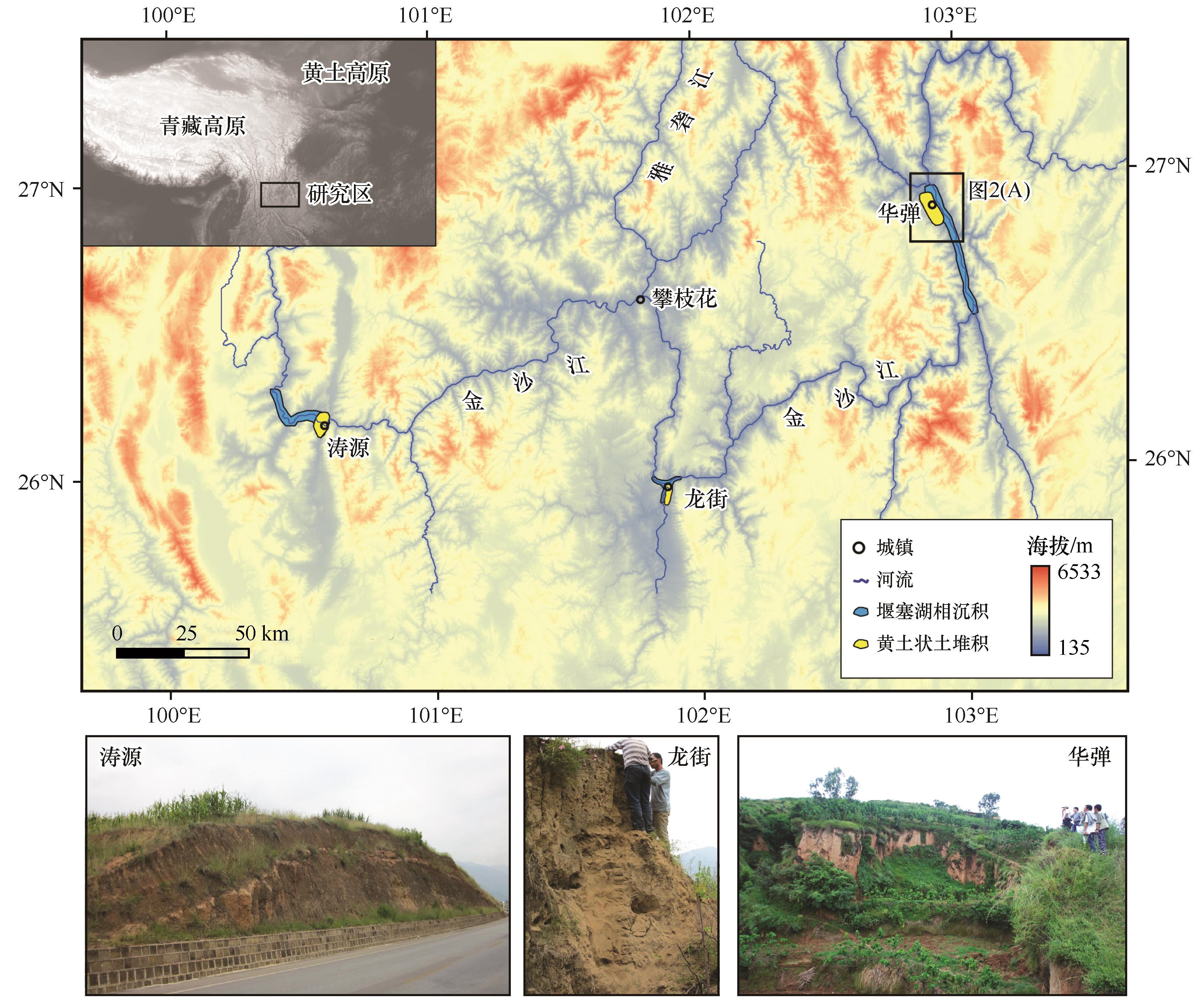
| 13 |
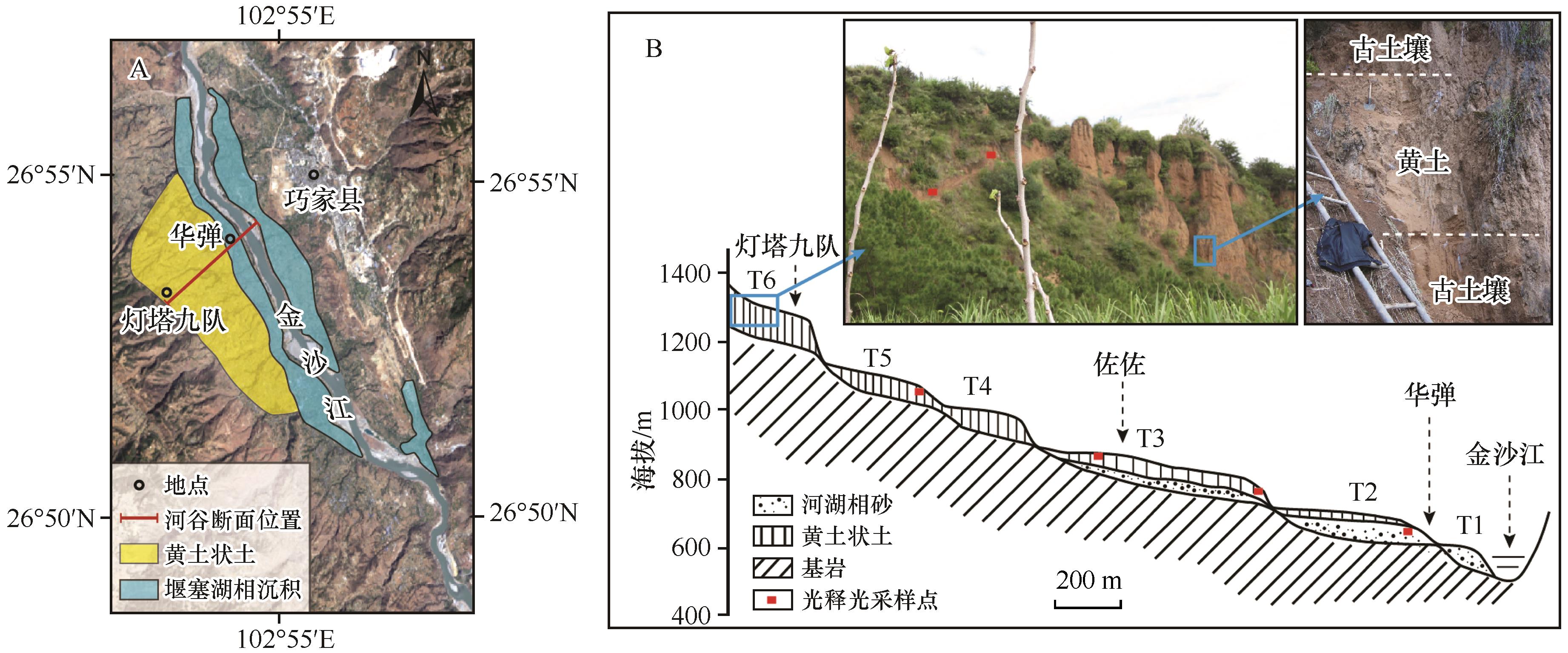
Sun J M.Provenance of loess material and formation of loess deposits on the Chinese Loess Plateau[J].Earth and Planetary Science Letters,2002,203:845-859.
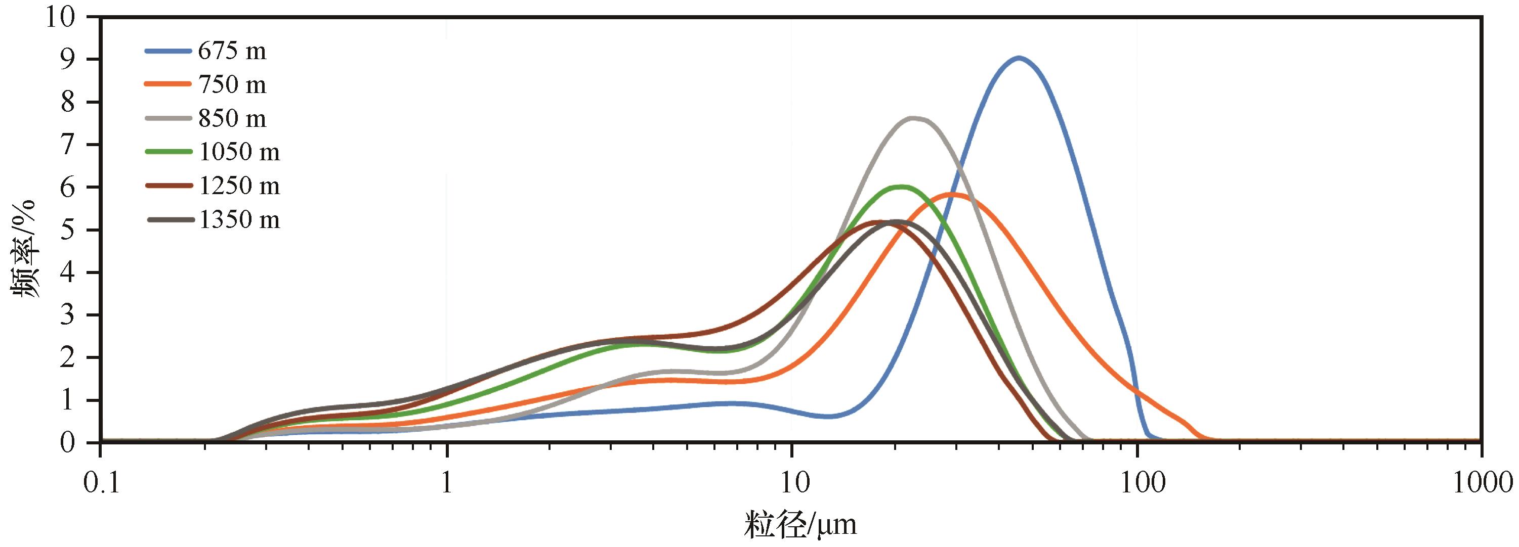
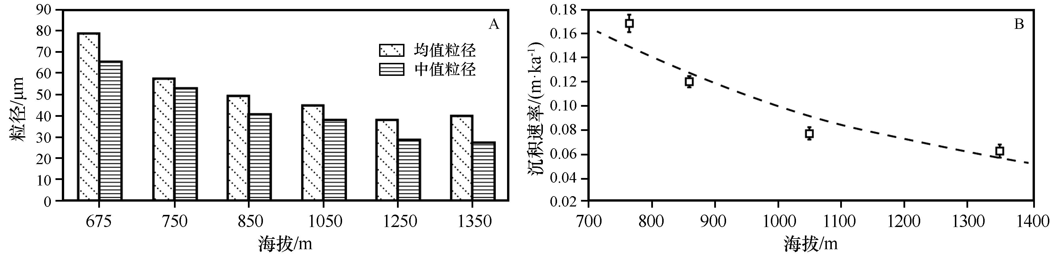
|
| 14 |
Sun Y B, An Z S.Late Pliocene-Pleistocene changes in mass accumulation rates of eolian deposits on the central Chinese Loess Plateau[J].Journal of Geophysical Research,2005,110(D23):D23101.
|
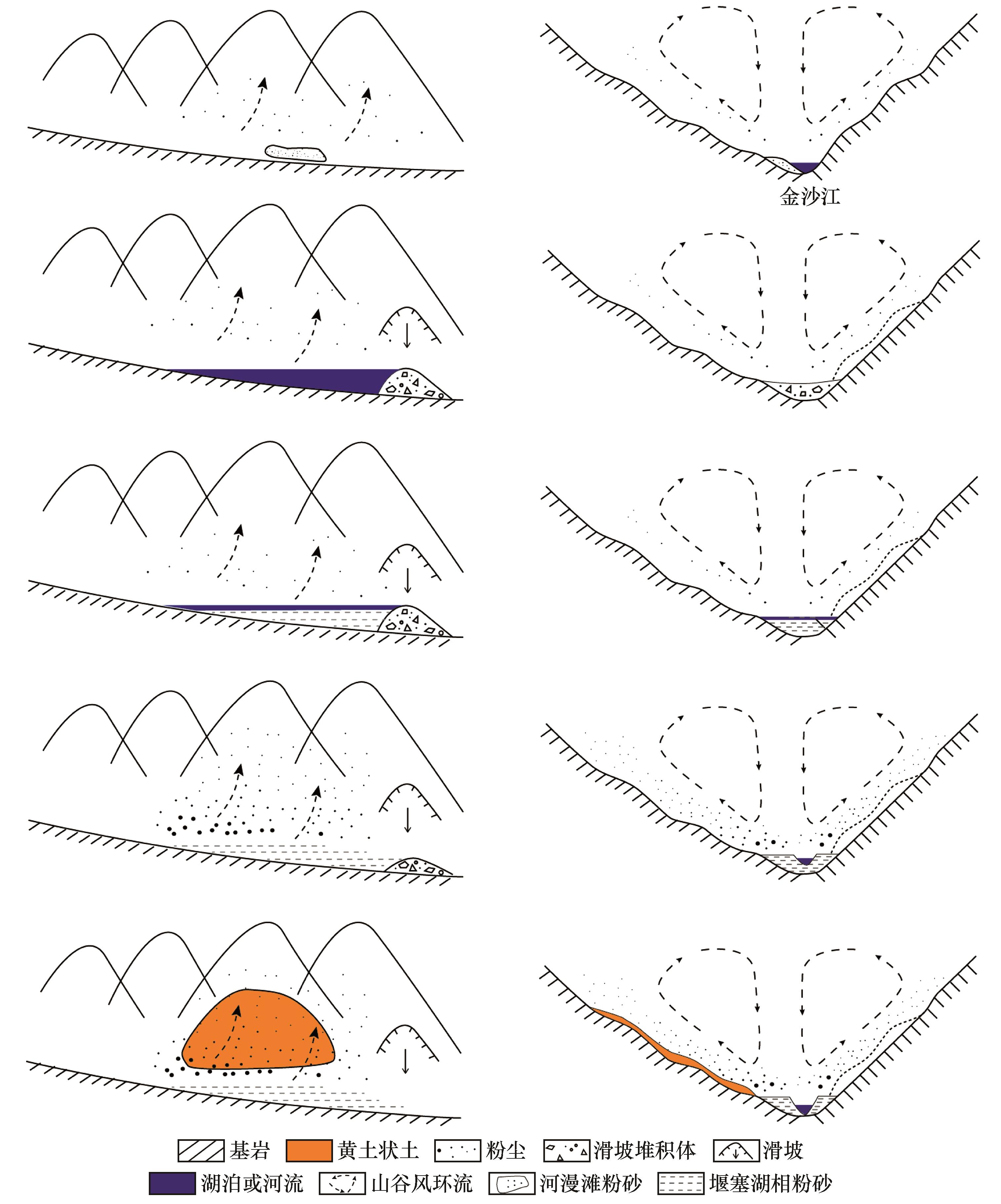
| 15 |
Pullen A, Kapp P, Mccallister A T,et al.Qaidam Basin and northern Tibetan Plateau as dust sources for the Chinese Loess Plateau and paleoclimatic implications[J].Geology,2011,39(11):1031-1034.
|
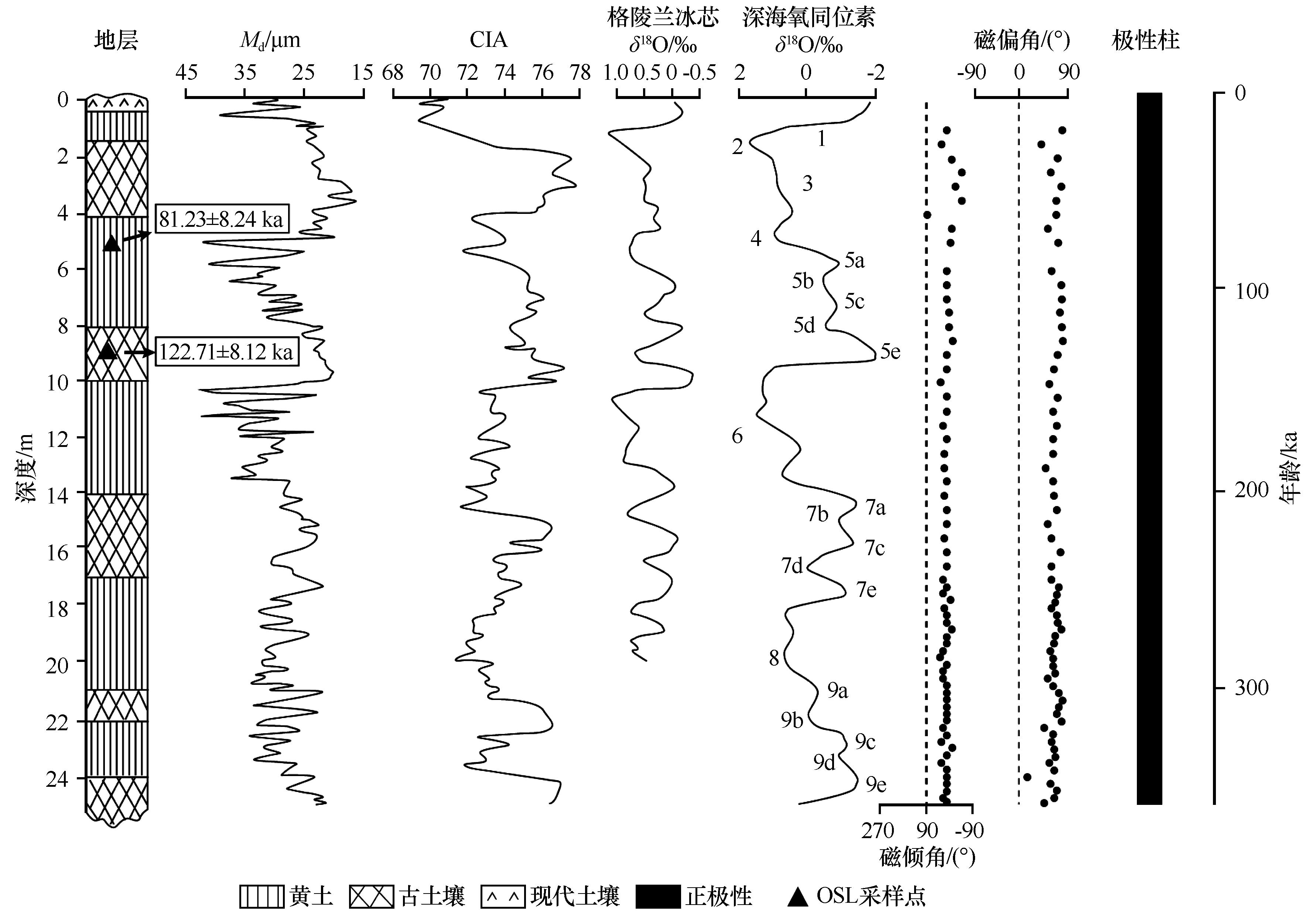
| 16 |
Nie J S, Stevens T, Rittner M,et al.Loess plateau storage of northeastern Tibetan plateau-derived Yellow River sediment[J].Nature Communications,2015,6(1):1-10.
|
| 17 |
杨达源.中国东部的第四纪风尘堆积与季风变迁[J].第四纪研究,1991(4):354-360.
|
| 18 |
Qiao Y S, Guo Z T, Hao Q Z,et al.Loess-soil sequences in southern Anhui Province:magnetostratigraphy and paleoclimatic significance[J].Chinese Science Bulletin,2003,48:2088-2093.
|
| 19 |
Wang X Y, Lu H Y, Zhang H Z,et al.Distribution,provenance,and onset of the Xiashu Loess in Southeast China with paleoclimatic implications[J].Journal of Asian Earth Sciences,2018,155:180-187.
|
| 20 |
Li X S, Han Z Y, Lu H Y,et al.Onset of Xiashu loess deposition in southern China by 0.9 Ma and its implications for regional aridification[J].Science China Earth Sciences,2018,61(3):256-269.
|
| 21 |
Han L, Hao Q, Qiao Y,et al.Geochemical evidence for provenance diversity of loess in southern China and its implications for glacial aridification of the northern subtropical region[J].Quaternary Science Reviews,2019,212:149-163.
|
| 22 |
Jiang Q D, Hao Q Z, Peng S Z,et al.Grain-size evidence for the transport pathway of the Xiashu loess in northern subtropical China and its linkage with fluvial systems[J].Aeolian Research,2020,46:100613.
|
| 23 |
张虎才.武都黄土堆积及晚更新世以来环境变迁研究[J].兰州大学学报(自然科学版),1997,33(1):105-114.
|
| 24 |
Fang X M, Lü L Q, Yang S L,et al.Loess in Kunlun Mountain and its implications on desert development and Tibetan Plateau uplift in west China[J].Science in China (Series D),2002,45(4):289-299.
|
| 25 |
Lehmkuhl F, Klinge M, ReesJones J,et al.Late Quaternary aeolian sedimentation in central and south-eastern Tibet[J].Quaternary International,2000,68/71:117-132.
|
| 26 |
Sun J M, Li S H, Muhs D R,et al.Loess sedimentation in Tibet:provenance,processes,and link with Quaternary glaciations[J].Quaternary Science Reviews,2007,26:2265-2280.
|
| 27 |
Guan Q Y, Pan B T, Gao H S,et al.Geochemical evidence of the Chinese loess provenance during the Late Pleistocene[J].Palaeogeography,Palaeoclimatology,Palaeoecology,2008,270:53-58.
|
| 28 |
Lai Z P, Kaiser K, Bruckne H.Luminescence-dated aeolian deposits of late Quaternary age in the southern Tibetan Plateau and their implications for landscape history[J].Quaternary Research,2009,72:421-430.
|
| 29 |
Guo B, Peng T, Yu H,et al.Magnetostratigraphy and palaeoclimatic significance of the late pliocene red clay:quaternary loess sequence in the Lanzhou Basin,Western Chinese Loess Plateau[J].Geophysical Research Letters,2020,47(3):GL086566.
|
| 30 |
Li X M, Peng T J, Ma Z H,et al.The sources and transport dynamics of eolian sediments in the NE Tibetan Plateau since 6.7 Ma[J].Geochemistry,Geophysics,Geosystems,2020,21(3):GC008682.
|
| 31 |
Yang S, Liu L, Chen H,et al.Variability and environmental significance of organic carbon isotopes in Ganzi loess since the last interglacial on the eastern Tibetan Plateau[J].CATENA,2021,196:104866.
|
| 32 |
曾方明,薛红盼.青藏高原东北部晚第四纪黄土-古土壤的元素组成及其物源指示[J].中国沙漠,2020,40(6):105-117.
|
| 33 |
周笃珺,马海州,高东林,等.青海湖南岸全新世黄土地球化学特征及气候环境意义[J].中国沙漠,2004,24(2):32-36.
|
| 34 |
张荣祖.横断山区干旱河谷[M].北京:科学出版社,1992.
|
| 35 |
汪阳春,柴宗新,刘淑珍,等.横断山地区的黄土及意义[J].山地学报,1999(4):300-304.
|
| 36 |
罗光照,沈林.云南涛源黄土的成因及湿陷性[J].工程勘察,1984(5):14-16.
|
| 37 |
蒋复初,吴锡浩,王书兵,等.金沙江巧家段河谷黄土状堆积的时代问题[J].地质力学学报,1999(4):37-42.
|
| 38 |
陈杰,史正涛,苏怀,等.巧家盆地黄土的粒度特征及其成因分析[J].云南地理环境研究,2009,21(3):46-52.
|
| 39 |
叶玉林,苏怀,董铭,等.元素和矿物组成揭示的金沙江干热河谷黄土状物质的物源[J].地球环境学报,2018,9(3):238-244.
|
| 40 |
Pan B T, Guan Q Y, Gao H S,et al.The origin and sources of loess-like sediment in the Jinsha River valley,SW China[J].Boreas,2014,43(1):121-131.
|
| 41 |
Wang H Y, Tong K Y, Hu G,et al.Dam and megafloods at the First Bend of the Yangtze River since the Last Glacial Maximum[J].Geomorphology,2021,373:107491.
|
| 42 |
徐则民.金沙江寨子村滑坡坝堰塞湖沉积及其对昔格达组地层成因的启示[J].地质论评,2011(5):69-80.
|
| 43 |
刘芬良,高红山,李宗盟,等.金沙江巧家-蒙姑段的阶地发育与河谷地貌演化[J].地理学报,2020,75(5):1095-1105.
|
| 44 |
刘芬良,高红山,李宗盟,等.金沙江龙街段晚更新世以来的阶地发育与河谷地貌演化[J].地球科学进展,2020,35(4):431-440.
|
| 45 |
孙东怀,鹿化煜, Rea D,等.中国黄土粒度的双峰分布及其古气候意义[J].沉积学报,2000(3):327-335.
|
| 46 |
Smalley I, O'Hara-Dhand K, Wint J,et al.Rivers and loess:the significance of long river transportation in the complex event-sequence approach to loess deposit formation[J].Quaternary International,2009,198:7-18.
|
| 47 |
靳鹤龄,董光荣,张春来.雅鲁藏布江河谷黄土的沉积特征及成因[J].中国沙漠,2000,20(1):15-20.
|
| 48 |
刘慧,李晓英,夏翠珍,等.雅鲁藏布江河谷加查-米林段沙丘成因[J].中国沙漠,2020,40(3):16-26.
|
| 49 |
Dansgaard W, Johnsen S J, Clausen H B,et al.Evidence for general instability of past climate from a 250-kyr ice-core record[J].Nature,1993,364:218-220.
|
| 50 |
Lisiecki L E, Raymo M E.A Pliocene-Pleistocene stack of 57 globally distributed benthic δ 18O records[J].Paleoceanography,2005,20(1): PA1003.
|
 ), 高红山2, 潘保田2, 李宗盟3

 甘公网安备 62010202000688号