中国沙漠 ›› 2025, Vol. 45 ›› Issue (1): 304-317.DOI: 10.7522/j.issn.1000-694X.2024.00188
• • 上一篇
张令光1( ), 沈才生1,2, 黄艳丽3, 扎多4, 拉珍5, 张焱6, 张正偲1()
收稿日期:2024-11-27
修回日期:2024-12-30
出版日期:2025-01-20
发布日期:2025-01-13
通讯作者:
张正偲
作者简介:张正偲(E-mail: zhangzhengcai@snnu.edu.cn)基金资助:
Lingguang Zhang1(), Caisheng Shen1,2, Yanli Huang3, Zaduo4, Lazhen5, Yan Zhang6, Zhengcai Zhang1()
Received:2024-11-27
Revised:2024-12-30
Online:2025-01-20
Published:2025-01-13
Contact:
Zhengcai Zhang
摘要:
风是风沙灾害形成的动力条件。雅鲁藏布江(简称“雅江”)流域风沙危害严重,但目前对该地区输沙势的时空差异研究不足,限制了对该地区风沙灾害形成过程、灾害防治措施的合理布局以及沙尘天气形成与发展的深入理解。对沿江39个气象站2022年全年风速和风向数据进行分析,计算输沙势,以评估雅江流域风沙活动强度。结果表明:(1)雅江流域输沙势空间差异明显,上游年输沙势最大(418.2±149.2 VU),下游其次(197.8±68.9 VU),中游最小(94.1±22.1 VU)。上游的仲巴和亚热,中游的曲松3个站点属于高风能环境;中游的昌果、定结、吞巴等9个站点属于中风能环境,其他站点属于低风能环境。上、中、下游地区不同季节之间输沙势均无统计学差异,意味着该地区全年均具有形成风沙灾害的动力条件。(2)上游和中游地区年合成输沙方向集中在ENE方向(50%和22%),下游地区集中在SW方向(50%)。(3)上游和下游地区不同季节合成输沙方向无显著差异,中游地区不同季节合成输沙方向存在明显差异,夏季集中在WSW-NNW方向(44%),其余季节则集中在N-E方向(38%~55%)。(4)根据合成输沙方向,雅江流域沙尘传输方向主要为NE和ENE,这与沿江地区沙丘分布位置相吻合。根据输沙势的研究结果,雅江流域的风沙灾害防治应该以高风能地区的河流宽谷、河漫滩和江心洲为主。
中图分类号:
张令光, 沈才生, 黄艳丽, 扎多, 拉珍, 张焱, 张正偲. 雅鲁藏布江流域输沙势空间特征[J]. 中国沙漠, 2025, 45(1): 304-317.
Lingguang Zhang, Caisheng Shen, Yanli Huang, Zaduo, Lazhen, Yan Zhang, Zhengcai Zhang. The spatial variations of sand drift potential in Yarlung Zangbo River Basin[J]. Journal of Desert Research, 2025, 45(1): 304-317.
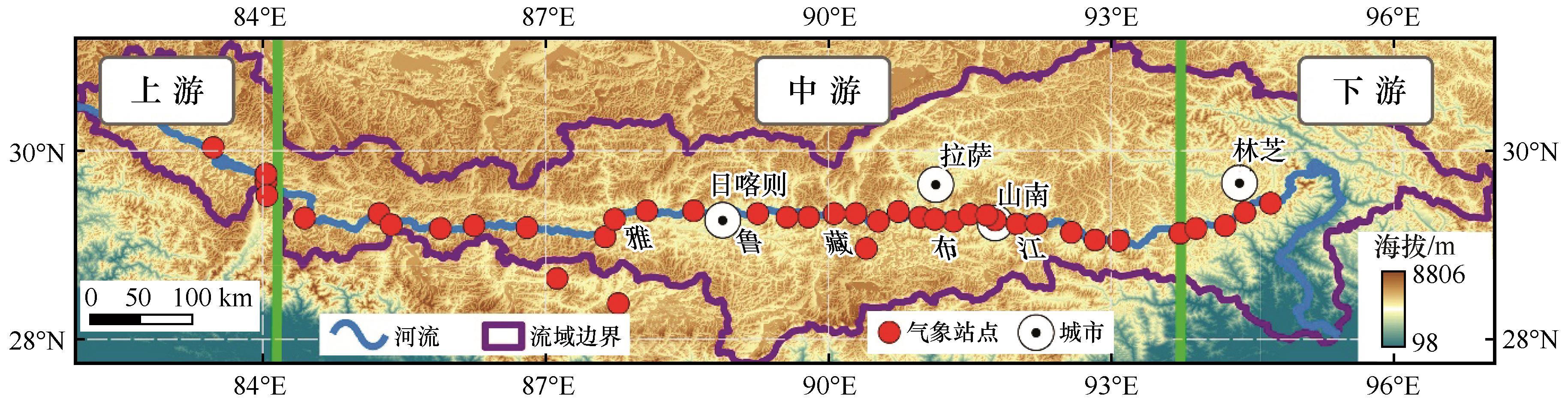
图1 研究区概况与气象站点分布注:基于自然资源部标准地图服务网站标准地图(审图号:GS(2019)3333号)制作,底图边界无修改
Fig.1 Location and distribution of stations in study area
| 流域划分 | 站点名称 | 纬度(N)/(°) | 经度(E)/(°) | 海拔/m |
|---|---|---|---|---|
| 上游 | 帕羊 | 30.04 | 83.47 | 4 583.6 |
| 拉让 | 29.76 | 84.03 | 4 583.0 | |
| 仲巴 | 29.68 | 84.03 | 4 558.8 | |
| 亚热 | 29.53 | 84.04 | 4 561.0 | |
| 中游 | 昌果 | 29.29 | 84.44 | 4 576.0 |
| 萨嘎 | 29.34 | 85.23 | 4 523.6 | |
| 折巴 | 29.22 | 85.36 | 4 511.0 | |
| 差那 | 29.18 | 85.88 | 4 442.0 | |
| 夏如 | 29.21 | 86.24 | 4 429.7 | |
| 多白 | 29.19 | 86.80 | 4 131.9 | |
| 定日 | 28.65 | 87.12 | 4 322.0 | |
| 定结 | 28.38 | 87.77 | 4 200.4 | |
| 拉孜 | 29.09 | 87.63 | 4 001.2 | |
| 曲玛 | 29.28 | 87.73 | 3 970.0 | |
| 彭措林 | 29.37 | 88.07 | 3 952.0 | |
| 谢通门 | 29.37 | 88.57 | 3 898.0 | |
| 江当 | 29.34 | 89.25 | 3 808.9 | |
| 联乡 | 29.30 | 89.56 | 3 934.0 | |
| 仁布 | 29.30 | 89.79 | 3 792.9 | |
| 尼木 | 29.34 | 90.06 | 3 757.2 | |
| 吞巴 | 29.34 | 90.29 | 3 695.0 | |
| 浪卡子 | 28.97 | 90.40 | 4 432.9 | |
| 茶巴拉 | 29.26 | 90.53 | 3 631.0 | |
| 曲水 | 29.36 | 90.74 | 3 589.2 | |
| 贡嘎 | 29.30 | 90.97 | 3 565.8 | |
| 杰德秀 | 29.28 | 91.13 | 3 566.0 | |
| 扎囊 | 29.26 | 91.33 | 3 567.6 | |
| 桑耶寺 | 29.33 | 91.50 | 3 569.8 | |
| 多颇章 | 29.32 | 91.68 | 3 710.2 | |
| 泽当 | 29.27 | 91.77 | 3 561.2 | |
| 桑日 | 29.23 | 92.00 | 3 584.5 | |
| 曲松 | 29.23 | 92.21 | 4 210.8 | |
| 加查 | 29.14 | 92.58 | 3 261.2 | |
| 仲达 | 29.06 | 92.83 | 3 143.0 | |
| 朗县 | 29.05 | 93.08 | 3 118.5 | |
| 下游 | 卧龙 | 29.13 | 93.73 | 2 984.2 |
| 扎西绕登 | 29.18 | 93.90 | 2 978.7 | |
| 羌纳 | 29.35 | 94.42 | 3 014.2 | |
| 丹娘 | 29.45 | 94.69 | 2 986.5 |
表1 雅鲁藏布江流域气象站点基本情况
Table 1 Synopsis of stations in Yarlung Zangbo River Basin
| 流域划分 | 站点名称 | 纬度(N)/(°) | 经度(E)/(°) | 海拔/m |
|---|---|---|---|---|
| 上游 | 帕羊 | 30.04 | 83.47 | 4 583.6 |
| 拉让 | 29.76 | 84.03 | 4 583.0 | |
| 仲巴 | 29.68 | 84.03 | 4 558.8 | |
| 亚热 | 29.53 | 84.04 | 4 561.0 | |
| 中游 | 昌果 | 29.29 | 84.44 | 4 576.0 |
| 萨嘎 | 29.34 | 85.23 | 4 523.6 | |
| 折巴 | 29.22 | 85.36 | 4 511.0 | |
| 差那 | 29.18 | 85.88 | 4 442.0 | |
| 夏如 | 29.21 | 86.24 | 4 429.7 | |
| 多白 | 29.19 | 86.80 | 4 131.9 | |
| 定日 | 28.65 | 87.12 | 4 322.0 | |
| 定结 | 28.38 | 87.77 | 4 200.4 | |
| 拉孜 | 29.09 | 87.63 | 4 001.2 | |
| 曲玛 | 29.28 | 87.73 | 3 970.0 | |
| 彭措林 | 29.37 | 88.07 | 3 952.0 | |
| 谢通门 | 29.37 | 88.57 | 3 898.0 | |
| 江当 | 29.34 | 89.25 | 3 808.9 | |
| 联乡 | 29.30 | 89.56 | 3 934.0 | |
| 仁布 | 29.30 | 89.79 | 3 792.9 | |
| 尼木 | 29.34 | 90.06 | 3 757.2 | |
| 吞巴 | 29.34 | 90.29 | 3 695.0 | |
| 浪卡子 | 28.97 | 90.40 | 4 432.9 | |
| 茶巴拉 | 29.26 | 90.53 | 3 631.0 | |
| 曲水 | 29.36 | 90.74 | 3 589.2 | |
| 贡嘎 | 29.30 | 90.97 | 3 565.8 | |
| 杰德秀 | 29.28 | 91.13 | 3 566.0 | |
| 扎囊 | 29.26 | 91.33 | 3 567.6 | |
| 桑耶寺 | 29.33 | 91.50 | 3 569.8 | |
| 多颇章 | 29.32 | 91.68 | 3 710.2 | |
| 泽当 | 29.27 | 91.77 | 3 561.2 | |
| 桑日 | 29.23 | 92.00 | 3 584.5 | |
| 曲松 | 29.23 | 92.21 | 4 210.8 | |
| 加查 | 29.14 | 92.58 | 3 261.2 | |
| 仲达 | 29.06 | 92.83 | 3 143.0 | |
| 朗县 | 29.05 | 93.08 | 3 118.5 | |
| 下游 | 卧龙 | 29.13 | 93.73 | 2 984.2 |
| 扎西绕登 | 29.18 | 93.90 | 2 978.7 | |
| 羌纳 | 29.35 | 94.42 | 3 014.2 | |
| 丹娘 | 29.45 | 94.69 | 2 986.5 |

图2 雅鲁藏布江流域年输沙势空间分布注:基于自然资源部标准地图服务网站标准地图(审图号:GS(2019)3333号)制作,底图边界无修改
Fig.2 Spatial distribution of drift potential in Yarlung Zangbo River Basin
| 流域划分 | 站点名称 | DP/VU | RDP/VU | RDD/(°) | RDP/DP | 流域划分 | 站点名称 | DP/VU | RDP/VU | RDD/(°) | RDP/DP |
|---|---|---|---|---|---|---|---|---|---|---|---|
| 上游 | 帕羊 | 169.0 | 143.6 | 90 | 0.85 | 中游 | 吞巴 | 251.2 | 133.1 | 40 | 0.53 |
| 拉让 | 252.6 | 190.6 | 67 | 0.75 | 浪卡子 | 3.2 | 2.2 | 117 | 0.68 | ||
| 仲巴 | 839.7 | 652.2 | 24 | 0.78 | 茶巴拉 | 1.7 | 0.8 | 114 | 0.48 | ||
| 亚热 | 411.7 | 385.5 | 29 | 0.94 | 曲水 | 0.7 | 0.6 | 97 | 0.88 | ||
| 中游 | 昌果 | 294.6 | 250.6 | 68 | 0.85 | 贡嘎 | 10.6 | 8.1 | 61 | 0.76 | |
| 萨嘎 | 9.5 | 0.3 | 135 | 0.04 | 杰德秀 | 5.1 | 2.7 | 316 | 0.53 | ||
| 折巴 | 269.8 | 210.9 | 61 | 0.78 | 扎囊 | 53.1 | 13.6 | 335 | 0.26 | ||
| 差那 | 267.0 | 254.0 | 28 | 0.95 | 桑耶寺 | 35.2 | 20.9 | 198 | 0.59 | ||
| 夏如 | 163.2 | 14.2 | 68 | 0.09 | 多颇章 | 20.6 | 13.1 | 194 | 0.63 | ||
| 多白 | 265.3 | 215.1 | 76 | 0.81 | 泽当 | 9.5 | 6.8 | 26 | 0.72 | ||
| 定日 | 52.0 | 49.6 | 88 | 0.95 | 桑日 | 45.0 | 20.8 | 3 | 0.46 | ||
| 定结 | 256.9 | 233.7 | 359 | 0.91 | 曲松 | 487.8 | 399.3 | 0 | 0.82 | ||
| 拉孜 | 11.6 | 8.1 | 71 | 0.70 | 加查 | 0.5 | 0.1 | 69 | 0.21 | ||
| 曲玛 | 15.3 | 2.9 | 110 | 0.19 | 仲达 | 100.8 | 86.7 | 247 | 0.86 | ||
| 彭措林 | 59.9 | 44.0 | 83 | 0.73 | 朗县 | 19.9 | 18.6 | 254 | 0.94 | ||
| 谢通门 | 62.2 | 30.1 | 112 | 0.48 | 下游 | 卧龙 | 194.3 | 141.2 | 213 | 0.73 | |
| 江当 | 12.5 | 10.1 | 75 | 0.80 | 扎西绕登 | 325.5 | 319.9 | 233 | 0.98 | ||
| 联乡 | 72.4 | 55.5 | 1 | 0.77 | 羌纳 | 264.0 | 237.6 | 358 | 0.90 | ||
| 仁布 | 19.8 | 9.7 | 72 | 0.49 | 丹娘 | 7.5 | 7.3 | 296 | 0.97 | ||
| 尼木 | 41.5 | 30.7 | 38 | 0.74 |
表2 雅鲁藏布江流域气象站点年输沙势
Table 2 Annual drift potential of stations in Yarlung Zangbo River Basin
| 流域划分 | 站点名称 | DP/VU | RDP/VU | RDD/(°) | RDP/DP | 流域划分 | 站点名称 | DP/VU | RDP/VU | RDD/(°) | RDP/DP |
|---|---|---|---|---|---|---|---|---|---|---|---|
| 上游 | 帕羊 | 169.0 | 143.6 | 90 | 0.85 | 中游 | 吞巴 | 251.2 | 133.1 | 40 | 0.53 |
| 拉让 | 252.6 | 190.6 | 67 | 0.75 | 浪卡子 | 3.2 | 2.2 | 117 | 0.68 | ||
| 仲巴 | 839.7 | 652.2 | 24 | 0.78 | 茶巴拉 | 1.7 | 0.8 | 114 | 0.48 | ||
| 亚热 | 411.7 | 385.5 | 29 | 0.94 | 曲水 | 0.7 | 0.6 | 97 | 0.88 | ||
| 中游 | 昌果 | 294.6 | 250.6 | 68 | 0.85 | 贡嘎 | 10.6 | 8.1 | 61 | 0.76 | |
| 萨嘎 | 9.5 | 0.3 | 135 | 0.04 | 杰德秀 | 5.1 | 2.7 | 316 | 0.53 | ||
| 折巴 | 269.8 | 210.9 | 61 | 0.78 | 扎囊 | 53.1 | 13.6 | 335 | 0.26 | ||
| 差那 | 267.0 | 254.0 | 28 | 0.95 | 桑耶寺 | 35.2 | 20.9 | 198 | 0.59 | ||
| 夏如 | 163.2 | 14.2 | 68 | 0.09 | 多颇章 | 20.6 | 13.1 | 194 | 0.63 | ||
| 多白 | 265.3 | 215.1 | 76 | 0.81 | 泽当 | 9.5 | 6.8 | 26 | 0.72 | ||
| 定日 | 52.0 | 49.6 | 88 | 0.95 | 桑日 | 45.0 | 20.8 | 3 | 0.46 | ||
| 定结 | 256.9 | 233.7 | 359 | 0.91 | 曲松 | 487.8 | 399.3 | 0 | 0.82 | ||
| 拉孜 | 11.6 | 8.1 | 71 | 0.70 | 加查 | 0.5 | 0.1 | 69 | 0.21 | ||
| 曲玛 | 15.3 | 2.9 | 110 | 0.19 | 仲达 | 100.8 | 86.7 | 247 | 0.86 | ||
| 彭措林 | 59.9 | 44.0 | 83 | 0.73 | 朗县 | 19.9 | 18.6 | 254 | 0.94 | ||
| 谢通门 | 62.2 | 30.1 | 112 | 0.48 | 下游 | 卧龙 | 194.3 | 141.2 | 213 | 0.73 | |
| 江当 | 12.5 | 10.1 | 75 | 0.80 | 扎西绕登 | 325.5 | 319.9 | 233 | 0.98 | ||
| 联乡 | 72.4 | 55.5 | 1 | 0.77 | 羌纳 | 264.0 | 237.6 | 358 | 0.90 | ||
| 仁布 | 19.8 | 9.7 | 72 | 0.49 | 丹娘 | 7.5 | 7.3 | 296 | 0.97 | ||
| 尼木 | 41.5 | 30.7 | 38 | 0.74 |
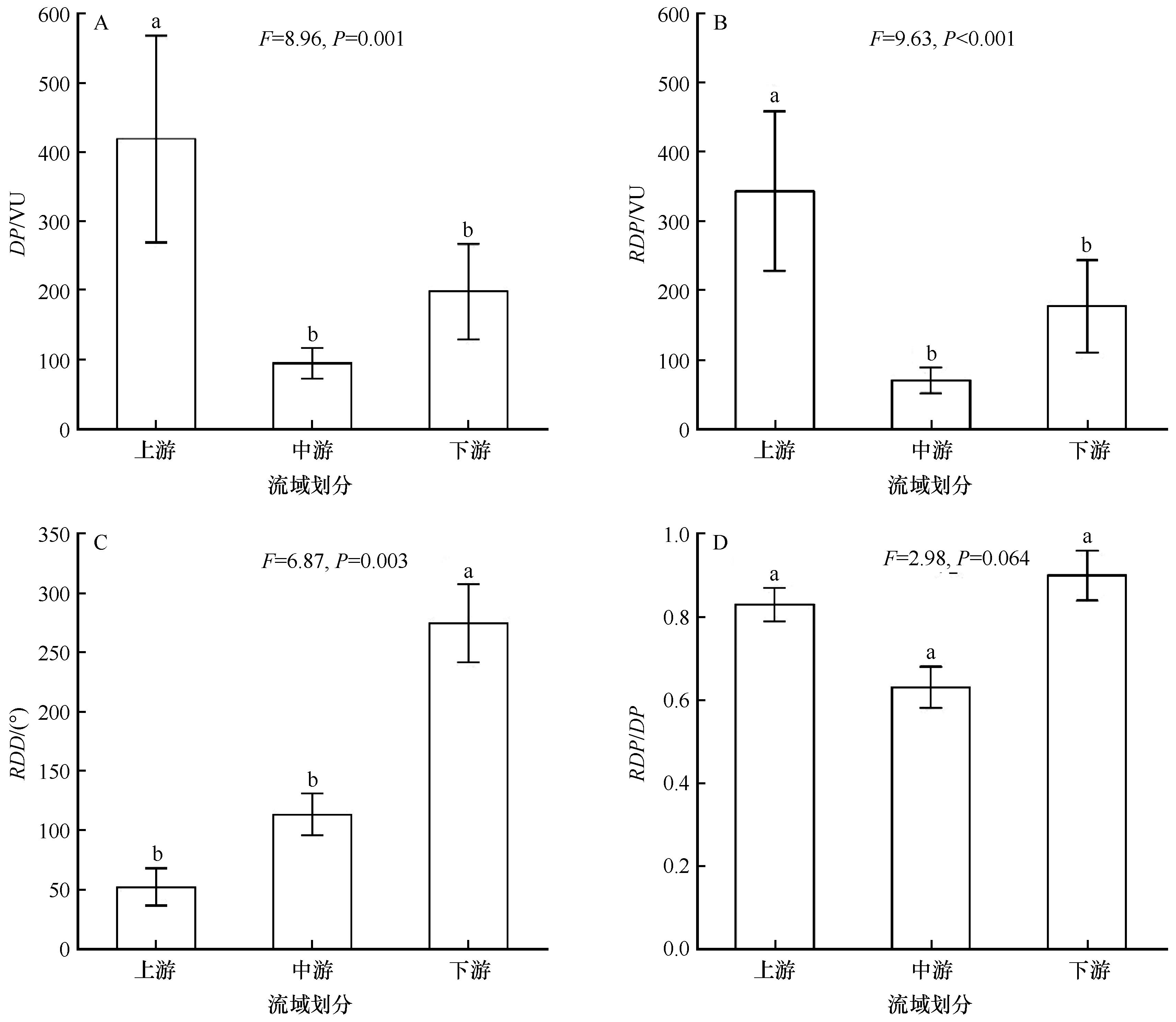
图3 流域不同分段全年输沙势注:a, b, c表示上、中、下游之间差异显著(P<0.05)
Fig.3 Drift potential of the whole year among upper, middle and downside reaches of Yarlung Zangbo River Basin. a, b and c indicate significant differences among different regions

图4 雅鲁藏布江流域春季输沙势空间分布注:基于自然资源部标准地图服务网站标准地图(审图号:GS(2019)3333号)制作,底图边界无修改
Fig.4 Spatial distribution of drift potential in Spring in Yarlung Zangbo River Basin

图5 雅鲁藏布江流域夏季输沙势空间分布注:基于自然资源部标准地图服务网站标准地图(审图号:GS(2019)3333号)制作,底图边界无修改
Fig.5 Spatial distribution of drift potential in Summer in Yarlung Zangbo River Basin

图6 雅鲁藏布江流域秋季输沙势空间分布注:基于自然资源部标准地图服务网站标准地图(审图号:GS(2019)3333号)制作,底图边界无修改
Fig.6 Spatial distribution of drift potential in Autumn in Yarlung Zangbo River Basin
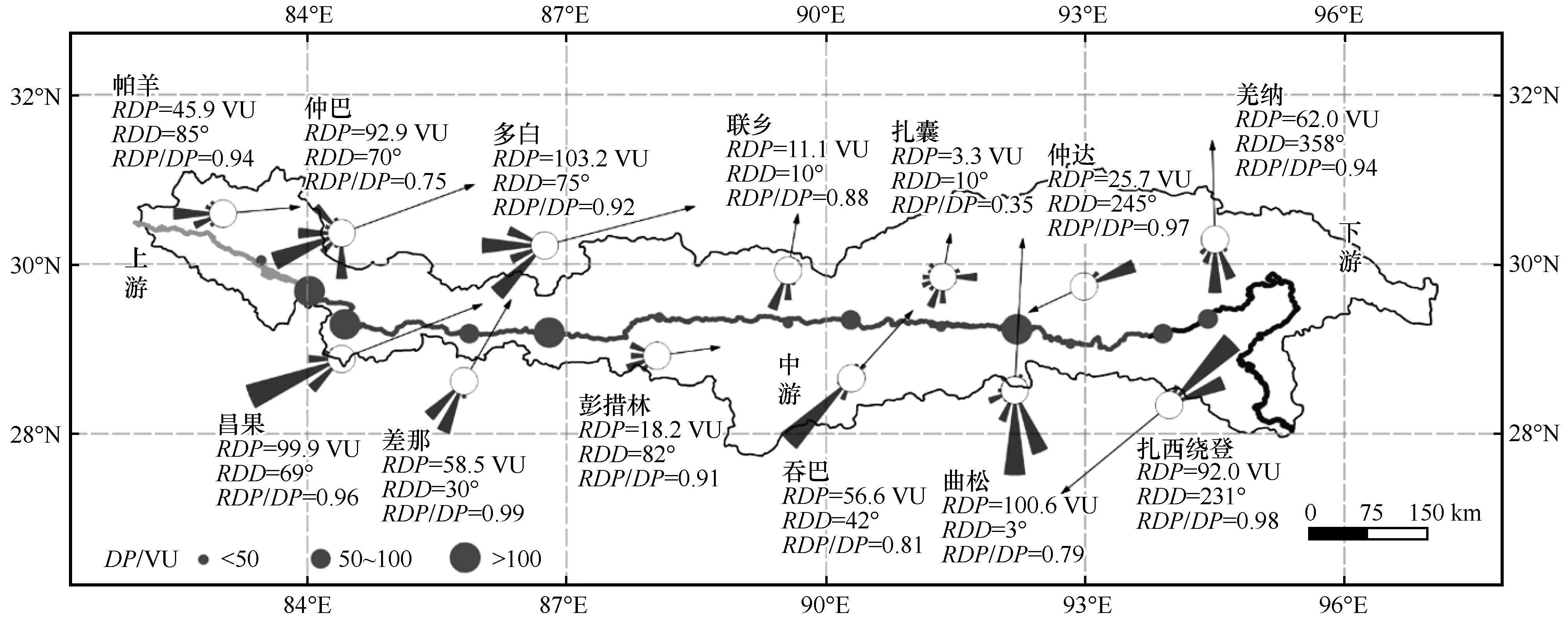
图7 雅鲁藏布江流域冬季输沙势空间分布注:基于自然资源部标准地图服务网站标准地图(审图号:GS(2019)3333号)制作,底图边界无修改
Fig.7 Spatial distribution of drift potential in Winter in Yarlung Zangbo River Basin
| 站点 | DP/VU | RDP/VU | RDD/(°) | RDP/DP | |||||||||||||
|---|---|---|---|---|---|---|---|---|---|---|---|---|---|---|---|---|---|
| 春季 | 夏季 | 秋季 | 冬季 | 春季 | 夏季 | 秋季 | 冬季 | 春季 | 夏季 | 秋季 | 冬季 | 春季 | 夏季 | 秋季 | 冬季 | ||
| 上游 | 帕羊 | 66.6 | 25.0 | 28.6 | 48.8 | 62.2 | 9.0 | 27.4 | 45.9 | 96 | 95 | 82 | 85 | 0.93 | 0.36 | 0.96 | 0.94 |
| 拉让 | 81.6 | 48.3 | 39.5 | 83.1 | 61.0 | 39.7 | 34.8 | 69.6 | 84 | 23 | 64 | 75 | 0.75 | 0.82 | 0.88 | 0.84 | |
| 仲巴 | 242.4 | 331.2 | 142.7 | 123.4 | 164.6 | 319.0 | 118.8 | 92.9 | 31 | 7 | 26 | 70 | 0.68 | 0.96 | 0.83 | 0.75 | |
| 亚热 | 127.2 | 164.0 | 70.3 | 50.2 | 114.2 | 162.0 | 67.6 | 42.0 | 31 | 27 | 29 | 33 | 0.90 | 0.99 | 0.96 | 0.84 | |
| 中游 | 昌果 | 76.2 | 51.02 | 63.2 | 104.1 | 67.4 | 25.6 | 59.2 | 99.9 | 72 | 49 | 70 | 69 | 0.88 | 0.50 | 0.94 | 0.96 |
| 萨嘎 | 2.1 | 3.4 | 0.6 | 3.4 | 1.2 | 1.7 | 0.1 | 0.2 | 23 | 192 | 62 | 4 | 0.58 | 0.49 | 0.16 | 0.06 | |
| 折巴 | 115.6 | 76.6 | 32.5 | 45.1 | 97.2 | 60.2 | 27.1 | 37.0 | 60 | 43 | 58 | 98 | 0.84 | 0.78 | 0.83 | 0.82 | |
| 差那 | 101.9 | 61.9 | 44.0 | 59.3 | 98.4 | 54.2 | 43.0 | 58.5 | 27 | 26 | 29 | 30 | 0.97 | 0.88 | 0.98 | 0.99 | |
| 夏如 | 46.2 | 59.4 | 16.2 | 41.4 | 13.8 | 27.7 | 7.3 | 28.1 | 99 | 291 | 352 | 110 | 0.30 | 0.47 | 0.45 | 0.68 | |
| 多白 | 74.9 | 26.5 | 52.0 | 111.9 | 63.3 | 6.3 | 42.9 | 103.2 | 79 | 92 | 70 | 75 | 0.85 | 0.24 | 0.82 | 0.92 | |
| 定日 | 17.0 | 0.9 | 7.2 | 26.9 | 16.6 | 0.1 | 7.1 | 26.1 | 89 | 86 | 77 | 91 | 0.97 | 0.07 | 0.99 | 0.97 | |
| 定结 | 113.1 | 59.8 | 38.8 | 45.1 | 105.4 | 56.3 | 36.0 | 36.2 | 358 | 357 | 359 | 0 | 0.93 | 0.94 | 0.93 | 0.80 | |
| 拉孜 | 4.1 | 2.0 | 1.8 | 3.6 | 3.3 | 1.3 | 1.5 | 2.7 | 64 | 36 | 60 | 104 | 0.80 | 0.63 | 0.85 | 0.75 | |
| 曲玛 | 6.0 | 4.7 | 1.7 | 2.8 | 2.4 | 1.8 | 0.5 | 1.7 | 117 | 192 | 63 | 17 | 0.40 | 0.38 | 0.31 | 0.59 | |
| 彭措林 | 19.7 | 9.4 | 10.7 | 20.1 | 13.9 | 4.4 | 8.7 | 18.2 | 81 | 121 | 70 | 82 | 0.70 | 0.47 | 0.81 | 0.91 | |
| 谢通门 | 16.1 | 12.1 | 12.1 | 21.8 | 9.3 | 7.3 | 7.0 | 15.2 | 105 | 194 | 125 | 81 | 0.57 | 0.61 | 0.58 | 0.70 | |
| 江当 | 4.1 | 0.7 | 2.4 | 5.3 | 3.3 | 0.5 | 2.1 | 5.3 | 85 | 267 | 71 | 71 | 0.79 | 0.67 | 0.87 | 0.99 | |
| 联乡 | 28.7 | 19.0 | 12.0 | 12.6 | 24.7 | 12.7 | 8.0 | 11.1 | 10 | 347 | 345 | 10 | 0.86 | 0.67 | 0.66 | 0.88 | |
| 仁布 | 3.8 | 7.7 | 2.5 | 5.9 | 2.5 | 1.6 | 2.3 | 5.6 | 74 | 184 | 61 | 61 | 0.65 | 0.20 | 0.94 | 0.96 | |
| 尼木 | 17.1 | 6.2 | 6.5 | 11.7 | 13.8 | 1.7 | 5.7 | 10.2 | 42 | 347 | 41 | 39 | 0.81 | 0.28 | 0.88 | 0.87 | |
| 吞巴 | 94.5 | 41.4 | 45.2 | 70.1 | 47.1 | 6.4 | 35.0 | 56.6 | 43 | 251 | 38 | 42 | 0.50 | 0.15 | 0.77 | 0.81 | |
| 浪卡子 | 1.5 | 0.5 | 0.3 | 0.9 | 1.0 | 0.4 | 0.2 | 0.7 | 125 | 116 | 122 | 102 | 0.63 | 0.84 | 0.62 | 0.73 | |
| 茶巴拉 | 0.6 | 0.5 | 0.1 | 0.5 | 0.5 | 0.1 | 0.1 | 0.5 | 155 | 161 | 100 | 68 | 0.81 | 0.16 | 0.98 | 0.90 | |
| 曲水 | 0.2 | 0.0 | 0.1 | 0.4 | 0.2 | 0.0 | 0.1 | 0.3 | 110 | 135 | 85 | 92 | 0.89 | 1.00 | 0.92 | 0.89 | |
| 贡嘎 | 5.8 | 0.7 | 1.9 | 2.1 | 4.5 | 0.1 | 1.7 | 1.8 | 56 | 47 | 76 | 62 | 0.78 | 0.17 | 0.88 | 0.84 | |
| 杰德秀 | 1.6 | 0.7 | 0.6 | 2.1 | 0.9 | 0.4 | 0.2 | 1.5 | 339 | 257 | 338 | 313 | 0.55 | 0.52 | 0.26 | 0.72 | |
| 扎囊 | 19.8 | 16.5 | 7.6 | 9.3 | 6.3 | 5.4 | 2.7 | 3.3 | 328 | 290 | 47 | 10 | 0.32 | 0.32 | 0.36 | 0.35 | |
| 桑耶寺 | 13.1 | 10.5 | 3.4 | 8.1 | 7.8 | 8.9 | 1.4 | 2.9 | 201 | 196 | 183 | 201 | 0.59 | 0.85 | 0.42 | 0.35 | |
| 多颇章 | 10.4 | 3.1 | 1.6 | 5.5 | 6.5 | 1.8 | 1.1 | 3.8 | 199 | 191 | 202 | 186 | 0.63 | 0.58 | 0.67 | 0.69 | |
| 泽当 | 3.2 | 1.2 | 1.3 | 3.9 | 2.6 | 0.6 | 0.9 | 3.0 | 18 | 77 | 31 | 22 | 0.82 | 0.53 | 0.67 | 0.77 | |
| 桑日 | 19.0 | 10.3 | 8.6 | 7.1 | 16.9 | 6.7 | 8.2 | 5.5 | 2 | 352 | 175 | 7 | 0.89 | 0.65 | 0.95 | 0.77 | |
| 曲松 | 176.0 | 65.6 | 118.7 | 127.5 | 132.6 | 56.4 | 110.3 | 100.6 | 356 | 4 | 1 | 3 | 0.75 | 0.86 | 0.93 | 0.79 | |
| 加查 | 0.3 | 0.2 | 0.0 | 0.0 | 0.2 | 0.1 | 0.0 | 0.0 | 107 | 321 | — | — | 0.56 | 0.60 | — | — | |
| 仲达 | 45.2 | 15.0 | 14.1 | 26.6 | 41.7 | 8.3 | 11.3 | 25.7 | 244 | 261 | 252 | 245 | 0.92 | 0.56 | 0.80 | 0.97 | |
| 朗县 | 7.1 | 3.4 | 4.9 | 4.4 | 6.5 | 3.2 | 4.6 | 4.3 | 257 | 249 | 252 | 254 | 0.92 | 0.94 | 0.94 | 0.98 | |
| 下游 | 卧龙 | 56.5 | 27.6 | 50.3 | 59.9 | 32.6 | 15.8 | 41.5 | 51.3 | 217 | 208 | 213 | 211 | 0.58 | 0.57 | 0.83 | 0.86 |
| 扎西绕登 | 118.3 | 55.8 | 57.7 | 93.7 | 116.6 | 54.8 | 56.8 | 92.0 | 234 | 235 | 230 | 231 | 0.98 | 0.98 | 0.98 | 0.98 | |
| 羌纳 | 81.9 | 77.6 | 38.1 | 66.3 | 73.1 | 68.8 | 34.2 | 62.0 | 352 | 2 | 359 | 358 | 0.89 | 0.89 | 0.90 | 0.94 | |
| 丹娘 | 2.4 | 1.8 | 0.7 | 2.6 | 2.4 | 1.8 | 0.7 | 2.5 | 296 | 295 | 299 | 295 | 0.97 | 0.98 | 0.99 | 0.98 | |
表3 雅鲁藏布江流域气象站季节输沙势
Table 3 Seasonal drift potential of stations in Yarlung Zangbo River Basin
| 站点 | DP/VU | RDP/VU | RDD/(°) | RDP/DP | |||||||||||||
|---|---|---|---|---|---|---|---|---|---|---|---|---|---|---|---|---|---|
| 春季 | 夏季 | 秋季 | 冬季 | 春季 | 夏季 | 秋季 | 冬季 | 春季 | 夏季 | 秋季 | 冬季 | 春季 | 夏季 | 秋季 | 冬季 | ||
| 上游 | 帕羊 | 66.6 | 25.0 | 28.6 | 48.8 | 62.2 | 9.0 | 27.4 | 45.9 | 96 | 95 | 82 | 85 | 0.93 | 0.36 | 0.96 | 0.94 |
| 拉让 | 81.6 | 48.3 | 39.5 | 83.1 | 61.0 | 39.7 | 34.8 | 69.6 | 84 | 23 | 64 | 75 | 0.75 | 0.82 | 0.88 | 0.84 | |
| 仲巴 | 242.4 | 331.2 | 142.7 | 123.4 | 164.6 | 319.0 | 118.8 | 92.9 | 31 | 7 | 26 | 70 | 0.68 | 0.96 | 0.83 | 0.75 | |
| 亚热 | 127.2 | 164.0 | 70.3 | 50.2 | 114.2 | 162.0 | 67.6 | 42.0 | 31 | 27 | 29 | 33 | 0.90 | 0.99 | 0.96 | 0.84 | |
| 中游 | 昌果 | 76.2 | 51.02 | 63.2 | 104.1 | 67.4 | 25.6 | 59.2 | 99.9 | 72 | 49 | 70 | 69 | 0.88 | 0.50 | 0.94 | 0.96 |
| 萨嘎 | 2.1 | 3.4 | 0.6 | 3.4 | 1.2 | 1.7 | 0.1 | 0.2 | 23 | 192 | 62 | 4 | 0.58 | 0.49 | 0.16 | 0.06 | |
| 折巴 | 115.6 | 76.6 | 32.5 | 45.1 | 97.2 | 60.2 | 27.1 | 37.0 | 60 | 43 | 58 | 98 | 0.84 | 0.78 | 0.83 | 0.82 | |
| 差那 | 101.9 | 61.9 | 44.0 | 59.3 | 98.4 | 54.2 | 43.0 | 58.5 | 27 | 26 | 29 | 30 | 0.97 | 0.88 | 0.98 | 0.99 | |
| 夏如 | 46.2 | 59.4 | 16.2 | 41.4 | 13.8 | 27.7 | 7.3 | 28.1 | 99 | 291 | 352 | 110 | 0.30 | 0.47 | 0.45 | 0.68 | |
| 多白 | 74.9 | 26.5 | 52.0 | 111.9 | 63.3 | 6.3 | 42.9 | 103.2 | 79 | 92 | 70 | 75 | 0.85 | 0.24 | 0.82 | 0.92 | |
| 定日 | 17.0 | 0.9 | 7.2 | 26.9 | 16.6 | 0.1 | 7.1 | 26.1 | 89 | 86 | 77 | 91 | 0.97 | 0.07 | 0.99 | 0.97 | |
| 定结 | 113.1 | 59.8 | 38.8 | 45.1 | 105.4 | 56.3 | 36.0 | 36.2 | 358 | 357 | 359 | 0 | 0.93 | 0.94 | 0.93 | 0.80 | |
| 拉孜 | 4.1 | 2.0 | 1.8 | 3.6 | 3.3 | 1.3 | 1.5 | 2.7 | 64 | 36 | 60 | 104 | 0.80 | 0.63 | 0.85 | 0.75 | |
| 曲玛 | 6.0 | 4.7 | 1.7 | 2.8 | 2.4 | 1.8 | 0.5 | 1.7 | 117 | 192 | 63 | 17 | 0.40 | 0.38 | 0.31 | 0.59 | |
| 彭措林 | 19.7 | 9.4 | 10.7 | 20.1 | 13.9 | 4.4 | 8.7 | 18.2 | 81 | 121 | 70 | 82 | 0.70 | 0.47 | 0.81 | 0.91 | |
| 谢通门 | 16.1 | 12.1 | 12.1 | 21.8 | 9.3 | 7.3 | 7.0 | 15.2 | 105 | 194 | 125 | 81 | 0.57 | 0.61 | 0.58 | 0.70 | |
| 江当 | 4.1 | 0.7 | 2.4 | 5.3 | 3.3 | 0.5 | 2.1 | 5.3 | 85 | 267 | 71 | 71 | 0.79 | 0.67 | 0.87 | 0.99 | |
| 联乡 | 28.7 | 19.0 | 12.0 | 12.6 | 24.7 | 12.7 | 8.0 | 11.1 | 10 | 347 | 345 | 10 | 0.86 | 0.67 | 0.66 | 0.88 | |
| 仁布 | 3.8 | 7.7 | 2.5 | 5.9 | 2.5 | 1.6 | 2.3 | 5.6 | 74 | 184 | 61 | 61 | 0.65 | 0.20 | 0.94 | 0.96 | |
| 尼木 | 17.1 | 6.2 | 6.5 | 11.7 | 13.8 | 1.7 | 5.7 | 10.2 | 42 | 347 | 41 | 39 | 0.81 | 0.28 | 0.88 | 0.87 | |
| 吞巴 | 94.5 | 41.4 | 45.2 | 70.1 | 47.1 | 6.4 | 35.0 | 56.6 | 43 | 251 | 38 | 42 | 0.50 | 0.15 | 0.77 | 0.81 | |
| 浪卡子 | 1.5 | 0.5 | 0.3 | 0.9 | 1.0 | 0.4 | 0.2 | 0.7 | 125 | 116 | 122 | 102 | 0.63 | 0.84 | 0.62 | 0.73 | |
| 茶巴拉 | 0.6 | 0.5 | 0.1 | 0.5 | 0.5 | 0.1 | 0.1 | 0.5 | 155 | 161 | 100 | 68 | 0.81 | 0.16 | 0.98 | 0.90 | |
| 曲水 | 0.2 | 0.0 | 0.1 | 0.4 | 0.2 | 0.0 | 0.1 | 0.3 | 110 | 135 | 85 | 92 | 0.89 | 1.00 | 0.92 | 0.89 | |
| 贡嘎 | 5.8 | 0.7 | 1.9 | 2.1 | 4.5 | 0.1 | 1.7 | 1.8 | 56 | 47 | 76 | 62 | 0.78 | 0.17 | 0.88 | 0.84 | |
| 杰德秀 | 1.6 | 0.7 | 0.6 | 2.1 | 0.9 | 0.4 | 0.2 | 1.5 | 339 | 257 | 338 | 313 | 0.55 | 0.52 | 0.26 | 0.72 | |
| 扎囊 | 19.8 | 16.5 | 7.6 | 9.3 | 6.3 | 5.4 | 2.7 | 3.3 | 328 | 290 | 47 | 10 | 0.32 | 0.32 | 0.36 | 0.35 | |
| 桑耶寺 | 13.1 | 10.5 | 3.4 | 8.1 | 7.8 | 8.9 | 1.4 | 2.9 | 201 | 196 | 183 | 201 | 0.59 | 0.85 | 0.42 | 0.35 | |
| 多颇章 | 10.4 | 3.1 | 1.6 | 5.5 | 6.5 | 1.8 | 1.1 | 3.8 | 199 | 191 | 202 | 186 | 0.63 | 0.58 | 0.67 | 0.69 | |
| 泽当 | 3.2 | 1.2 | 1.3 | 3.9 | 2.6 | 0.6 | 0.9 | 3.0 | 18 | 77 | 31 | 22 | 0.82 | 0.53 | 0.67 | 0.77 | |
| 桑日 | 19.0 | 10.3 | 8.6 | 7.1 | 16.9 | 6.7 | 8.2 | 5.5 | 2 | 352 | 175 | 7 | 0.89 | 0.65 | 0.95 | 0.77 | |
| 曲松 | 176.0 | 65.6 | 118.7 | 127.5 | 132.6 | 56.4 | 110.3 | 100.6 | 356 | 4 | 1 | 3 | 0.75 | 0.86 | 0.93 | 0.79 | |
| 加查 | 0.3 | 0.2 | 0.0 | 0.0 | 0.2 | 0.1 | 0.0 | 0.0 | 107 | 321 | — | — | 0.56 | 0.60 | — | — | |
| 仲达 | 45.2 | 15.0 | 14.1 | 26.6 | 41.7 | 8.3 | 11.3 | 25.7 | 244 | 261 | 252 | 245 | 0.92 | 0.56 | 0.80 | 0.97 | |
| 朗县 | 7.1 | 3.4 | 4.9 | 4.4 | 6.5 | 3.2 | 4.6 | 4.3 | 257 | 249 | 252 | 254 | 0.92 | 0.94 | 0.94 | 0.98 | |
| 下游 | 卧龙 | 56.5 | 27.6 | 50.3 | 59.9 | 32.6 | 15.8 | 41.5 | 51.3 | 217 | 208 | 213 | 211 | 0.58 | 0.57 | 0.83 | 0.86 |
| 扎西绕登 | 118.3 | 55.8 | 57.7 | 93.7 | 116.6 | 54.8 | 56.8 | 92.0 | 234 | 235 | 230 | 231 | 0.98 | 0.98 | 0.98 | 0.98 | |
| 羌纳 | 81.9 | 77.6 | 38.1 | 66.3 | 73.1 | 68.8 | 34.2 | 62.0 | 352 | 2 | 359 | 358 | 0.89 | 0.89 | 0.90 | 0.94 | |
| 丹娘 | 2.4 | 1.8 | 0.7 | 2.6 | 2.4 | 1.8 | 0.7 | 2.5 | 296 | 295 | 299 | 295 | 0.97 | 0.98 | 0.99 | 0.98 | |
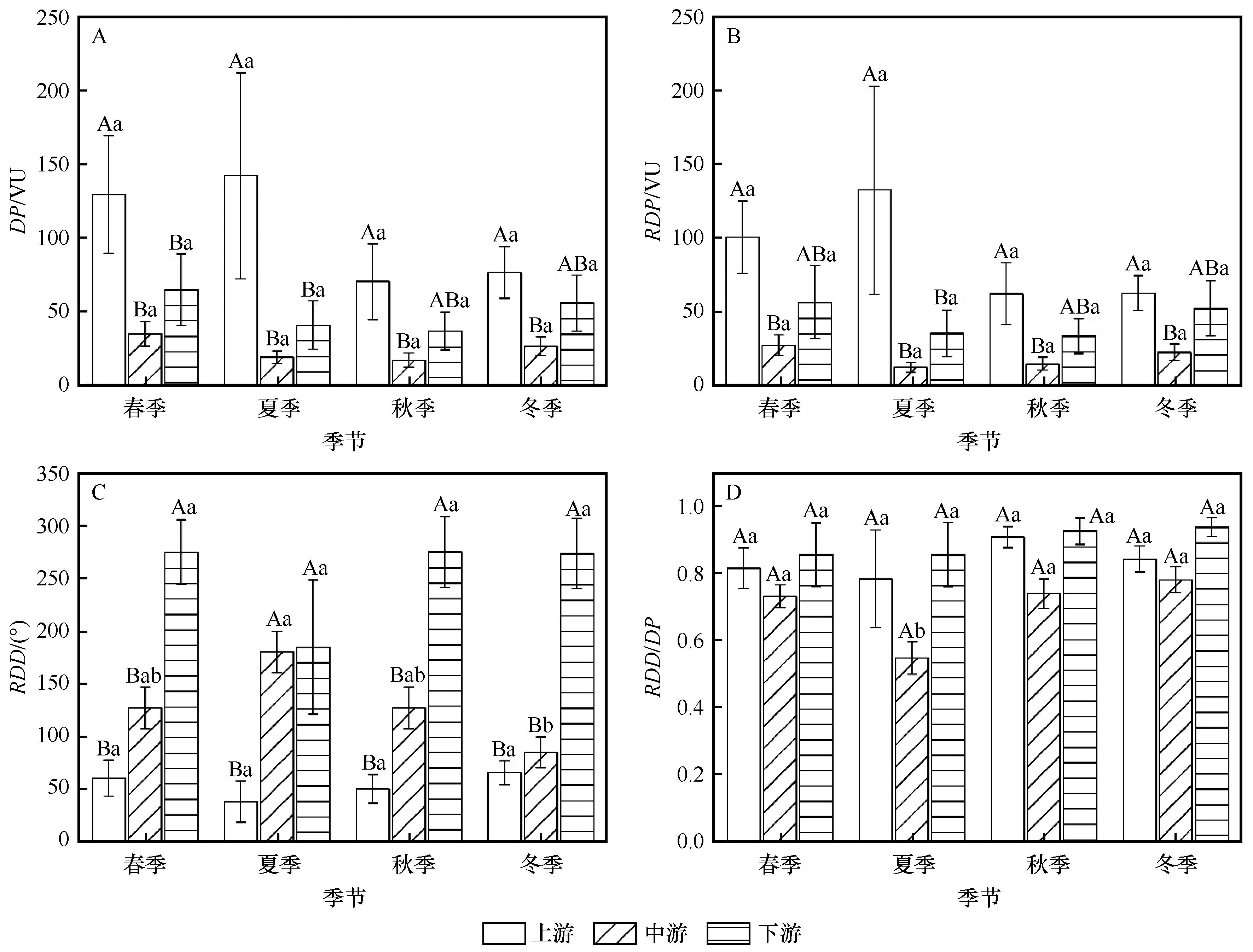
图8 雅鲁藏布江流域不同地区季节输沙势特征注:不同大写字母表示同一季节上、中、下游之间差异显著(P<0.05);不同小写字母表示同一流域分段不同季节之间差异显著(P<0.05)
Fig.8 Seasonal drift potential statistics among upper, middle and downside reaches of Yarlung Zangbo River Basin. Different capital letters indicate significant differences among different regions in the same season, and different lowercases indicate significant differences among different seasons in the same region (P<0.05)
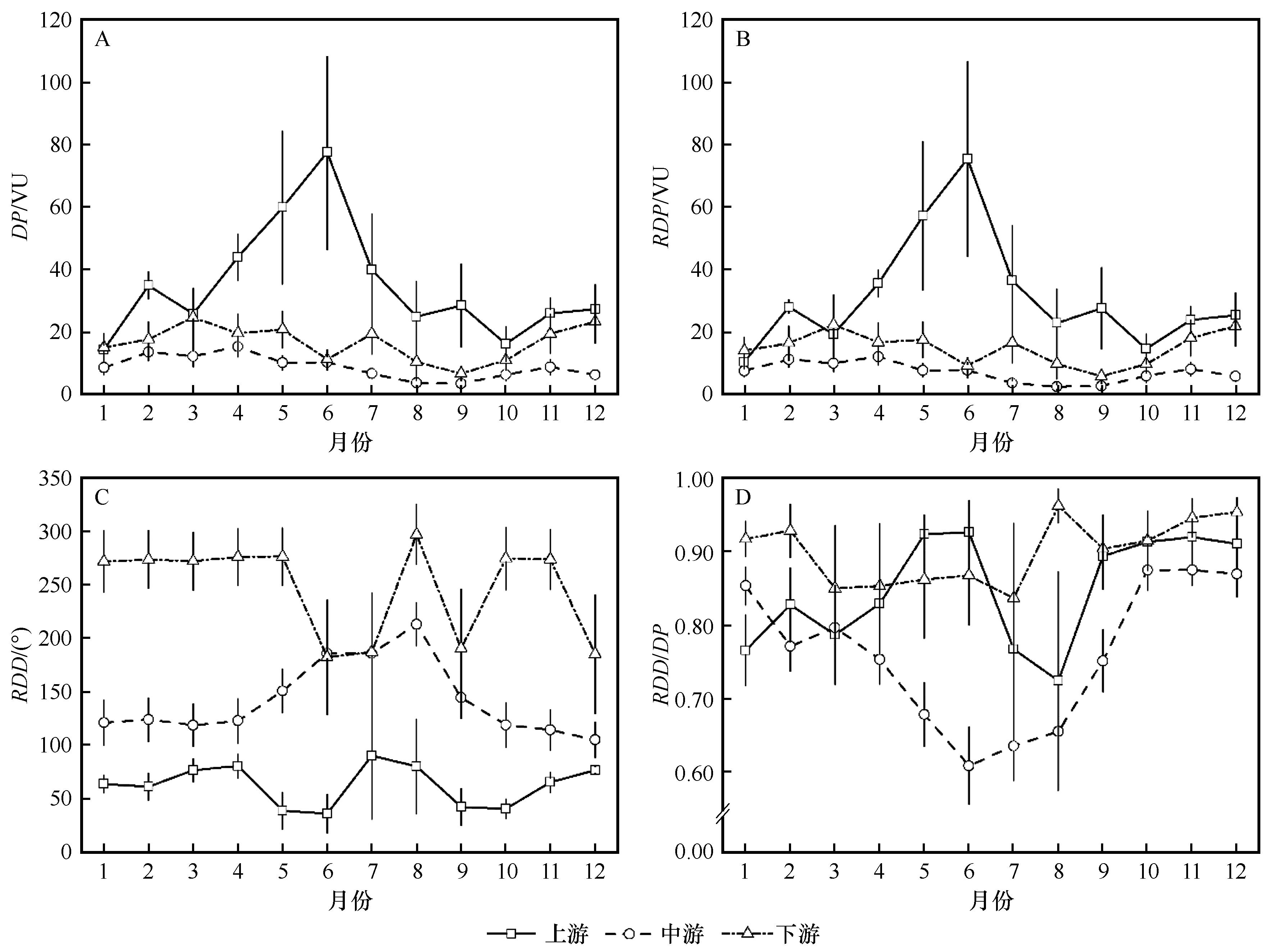
图9 雅鲁藏布江流域月输沙势变化
Fig.9 Monthly drift potential of Yarlung Zangbo River Basin

图10 雅鲁藏布江流域沙丘分布注:基于自然资源部标准地图服务网站标准地图(审图号:GS(2019)3333号)制作,底图边界无修改
Fig.10 Spatial distribution of sand dunes in Yarlung Zangbo River Basin
| 1 | Dong Z B, Hu G Y, Qian G Q,et al.High-altitude aeolian research on the Tibetan Plateau[J].Reviews of Geophysics,2017,55(4):864-901. |
| 2 | Dong Z B, Hu G Y, Yan C Z,et al.Aeolian desertification and its causes in the Zoige Plateau of China's Qinghai–Tibetan Plateau[J].Environmental Earth Sciences,2010,59(8):1731-1740. |
| 3 | Shen W S, Li H D, Sun M,et al.Dynamics of aeolian sandy land in the Yarlung Zangbo River basin of Tibet,China from 1975 to 2008[J].Global and Planetary Change,2012,86-87:37-44. |
| 4 | 孙小雲,房彦杰,赵景峰,等.塔克拉玛干沙漠输沙势时空分布特征[J].干旱区地理,2020,43(1):38-47. |
| 5 | 张正偲,董治宝,赵爱国,等.库姆塔格沙漠风沙活动特征[J].干旱区地理,2010,33(6):939-946. |
| 6 | 庞营军,吴波,贾晓红,等.毛乌素沙地风况及输沙势特征[J].中国沙漠,2019,39(1):62-67. |
| 7 | Shen Y P, Zhang C L, Zhang Y J.Assessment of wind erosivity based on wind speed conversion over different averaging times[J].Journal of Soils and Sediments,2023,23(5):2037-2047. |
| 8 | Zhang C L, Shen Y P, Li Q,et al.Sediment grain-size characteristics and relevant correlations to the aeolian environment in China's eastern desert region[J].Science of the Total Environment,2018,627:586-599. |
| 9 | 张正偲,董治宝,赵爱国,等.输沙量与输沙势的关系[J].中国沙漠,2011,31(4):824-827. |
| 10 | Abbasi H R, Opp C, Groll M,et al.Wind regime and aeolian sand transport in Khuzestan Sand Sea[J].Aeolian Research,2021,53:100746. |
| 11 | Louassa S.Sand drift potential in western Algerian Hautes Plaines[J].Aeolian Research,2018,34:27-34. |
| 12 | Meng N, Wang N A, Zhao L Q,et al.Wind regimes and associated sand dune types in the hinterland of the Badain Jaran Desert,China[J].Journal of Arid Land,2022,14(5):473-489. |
| 13 | Hu G Y, Dong Z B, Zhang Z C,et al.Wind regime and aeolian landforms on the eastern shore of Qinghai Lake,northeastern Tibetan Plateau,China[J].Journal of Arid Environments,2021,188:104451. |
| 14 | 王永胜,杨文斌,李永华,等.库姆塔格沙漠东缘荒漠绿洲过渡带风况及输沙势[J].干旱区资源与环境,2015,29(1):140-144. |
| 15 | 张正偲,董治宝,赵爱国.输沙势计算中的“时距”问题[J].干旱区地理,2010,33(2):177-182. |
| 16 | Zhang Z C, Dong Z B, Zhao A G.The effect of the time interval used to calculate mean wind velocity on the calculated drift potential,relative drift potential,and resultant drift direction for sands from three deserts in northern China[J].Theoretical and Applied Climatology,2016,123(1/2):151-160. |
| 17 | Zhou N, Li Q, Zhang C L,et al.Grain size characteristics of aeolian sands and their implications for the aeolian dynamics of dunefields within a river valley on the southern Tibet Plateau:a case study from the Yarlung Zangbo river valley[J].CATENA,2021,196:104794. |
| 18 | Zhang Z C, Ma P F, La Z,et al.Aeolian sediment provenance and transport in the upper and middle reaches of the Yarlung Zangbo River,Tibet Plateau[J].Basin Research,2022,35(2):762-783. |
| 19 | Yang J H, Xia D S, Wang S Y,et al.Near-surface wind environment in the Yarlung Zangbo River basin,southern Tibetan Plateau[J].Journal of Arid Land,2020,12(6):917-936. |
| 20 | 张正偲,张焱,马鹏飞,等.雅鲁藏布江中游风沙区典型下垫面空气动力学参数研究[J].干旱区研究,2022,39(4):997-1005. |
| 21 | 李森,董光荣,申建友,等.雅鲁藏布江河谷风沙地貌形成机制与发育模式[J].中国科学:地球科学,1999,29(1):88-96. |
| 22 | Li T Y, Zhang J F, Wu Y Q,et al.Holocene aeolian activities linked to Indian summer monsoon in the middle reaches of the Yarlung Zangbo River[J].Journal of Geographical Sciences,2020,30(12):2002-2014. |
| 23 | Ma P F, Zhang Z C, Zhang Y,et al.Effect of meteorological conditions on PM10 concentrations in the middle reaches of the Yarlung Zangbo River,Tibet Plateau[J].Theoretical and Applied Climatology,2023,151(1/2):725-737. |
| 24 | Zhang Z C, Zhang Y, Ma P F,et al.Aeolian sediment transport rates in the middle reaches of the Yarlung Zangbo River,Tibet Plateau[J].Science of the Total Environment,2022,826:154238. |
| 25 | 刘婷,贾晓鹏,陈定梅,等.雅鲁藏布江中游平坦流沙地表空气动力学特征[J].中国沙漠,2023,43(5):194-203. |
| 26 | 马鹏飞,高佳佳,扎多,等.雅鲁藏布江中游风沙灾害区地表沉积物养分特征[J].干旱区资源与环境,2021,35(6):96-101. |
| 27 | 张焱,马鹏飞,潘凯佳,等.雅鲁藏布江中游江心洲和河漫滩沉积物粒度特征[J].干旱区资源与环境,2022,36(8):161-168. |
| 28 | Zhang Y, Zhang Z C, Ma P F,et al.Wind regime features and their impacts on the middle reaches of the Yarlung Zangbo River on the Tibetan Plateau,China[J].Journal of Arid Land,2023,15(10):1174-1195. |
| 29 | 刘佳驹,李金城,郭怀成,等.基于人工神经网络的雅鲁藏布江水化学变化趋势研究[J].北京大学学报(自然科学版),2023,59(6):1043-1051. |
| 30 | 李世剑,康满春,刘流,等.雅鲁藏布江上游干、支流沉积物总有机碳分布特征初探[J].冰川冻土,2024,46(2):443-456. |
| 31 | Zhou N, Zhang C L, Wu X X,et al.The geomorphology and evolution of aeolian landforms within a river valley in a semi-humid environment:a case study from Mainling Valley,Qinghai-Tibet Plateau[J].Geomorphology,2014,224:27-38. |
| 32 | Fryberger S G, Dean G.Dune forms and wind regime[M]//McKee E D.A Study of Global Sand Seas. Hawaii,USA:University Press of the Pacific,1979. |
| 33 | 赵宏胜,党晓宏,蒙仲举,等.黄河流域西柳沟中游输沙势及风沙入黄量估算[J].中国环境科学,2024,44(5):2606-2618. |
| 34 | 夏敦胜,杨军怀,王树源,等.雅鲁藏布江流域风成沉积空间格局、沉积模式及其环境效应[J].地学前缘,2023,30(4):229-244. |
| 35 | 田越,苗峻峰.中国地区山谷风研究进展[J].气象科技,2019,47(1):41-51. |
| 36 | 杨军怀,夏敦胜,高福元,等.雅鲁藏布江流域风成沉积研究进展[J].地球科学进展,2020,35(8):863-877. |
| 37 | 苟诗薇,伍永秋,夏冬冬,等.青藏高原冬、春季沙尘暴频次时空分布特征及其环流背景[J].自然灾害学报,2012,21(5):135-143. |
| 38 | Yang Z L, Qian G Q, Dong Z B,et al.Migration of barchan dunes and factors that influence migration in the Sanlongsha dune field of the northern Kumtagh Sand Sea,China[J].Geomorphology,2021,378:107615. |
| 39 | Zamani S, Mahmoodabadi M, Yazdanpanah N,et al.Meteorological application of wind speed and direction linked to remote sensing images for the modelling of sand drift potential and dune morphology[J].Meterological Applications,2020,27(1):e1851. |
| 40 | Liu Y, Wang Y S, Shen T.Spatial distribution and formation mechanism of aeolian sand in the middle reaches of the Yarlung Zangbo River[J].Journal of Mountain Science,2019,16(9):1987-2000. |
| 41 | Du S S, Wu Y Q, Tan L H,et al.Geochemical characteristics of fine and coarse fractions of sediments in the Yarlung Zangbo River Basin (southern Tibet,China)[J].Environmental Earth Sciences,2018,77(9):337. |
| 42 | Wang B N, Gong J F, Zuza A V,et al.Aeolian sand dunes alongside the Yarlung River in southern Tibet:a provenance perspective[J].Geological Journal,2021,56(5):2625-2636. |
| [1] | 高娜, 胡光印, 董治宝. 共和盆地沙地空间分布格局变化特征[J]. 中国沙漠, 2025, 45(1): 204-214. |
| [2] | 郭酉元, 钱广强, 杨转玲, 邢学刚. 库姆塔格沙漠三垄沙地区砾波纹形态、粒度及环境风况[J]. 中国沙漠, 2024, 44(4): 37-45. |
| [3] | 雍天, 张金霞, 陈丽娟, 席海洋, 张斌武, 甘开元. 乌兰布和沙漠沿黄河段土壤水盐空间分异特征及其成因[J]. 中国沙漠, 2024, 44(3): 247-258. |
| [4] | 缑永涛, 吴永祥, 彭波, 张勇, 孔会平, 赵兴红, 冀鹏举, 李云昊, 何明珠, 邵梅, 谭明亮, 逯军峰. 乌玛高速公路腾格里沙漠段防护体系典型断面风沙活动特征[J]. 中国沙漠, 2024, 44(3): 279-289. |
| [5] | 赵宏胜, 高永, 蒙仲举, 李婉娇, 冯霜, 党晓宏. 黄河上游十大孔兑区域风能环境及输沙势特征[J]. 中国沙漠, 2024, 44(3): 85-95. |
| [6] | 缑永涛, 吴永祥, 彭波, 杨昊, 马金库, 王朝晖, 白海龙, 何明珠, 谭明亮, 邵梅, 逯军峰. 乌玛高速公路腾格里沙漠段防护体系不同配置措施固沙效应评估[J]. 中国沙漠, 2024, 44(2): 264-272. |
| [7] | 李强. 酒额铁路酒泉至东风段典型沙害区段风沙环境特征[J]. 中国沙漠, 2023, 43(6): 220-228. |
| [8] | 李雨薇, 王博, 包玉海, 韩彦隆, 闫茂林, 王伟峰. 草原风蚀坑发育对土壤生态化学计量的影响[J]. 中国沙漠, 2023, 43(5): 166-175. |
| [9] | 李继彦, 徐德华, 张姚姚, 薛倩文, 周玲. 柴达木盆地风能环境特征[J]. 中国沙漠, 2023, 43(5): 223-231. |
| [10] | 刘茜雅, 王海兵, 左合君, 温苏雅勒图, 霍海鹰. 巴音温都尔沙漠风况及输沙势特征[J]. 中国沙漠, 2023, 43(5): 41-48. |
| [11] | 张宏雪, 张克存, 安志山, 鱼燕萍. 敦煌-格尔木铁路沿线荒漠灌丛风动力环境与沉积物粒度特征[J]. 中国沙漠, 2023, 43(5): 49-58. |
| [12] | 陶海璇, 郭春秀, 马俊梅, 王忠文, 赵赫然, 宋达成, 何芳兰. 干旱沙区土壤结皮发育对草本植物土壤种子库的影响[J]. 中国沙漠, 2023, 43(4): 89-97. |
| [13] | 姜亚东, 吕世杰, 刘红梅, 娜仁花, 刘昕宇. 巴丹吉林沙漠东缘主要灌木数量特征及空间分布[J]. 中国沙漠, 2023, 43(3): 295-304. |
| [14] | 曲书锋, 张国明, 董苗, 徐俊泉, 尚鹏, 严平, 刘连友, 杜洁雯. 阿尔金山国家级自然保护区东北部风况及输沙势特征[J]. 中国沙漠, 2023, 43(2): 114-120. |
| [15] | 潘加朋, 张克存, 安志山, 张宏雪, 薛承杰. 风沙治理工程综合效益分析[J]. 中国沙漠, 2023, 43(2): 233-242. |
| 阅读次数 | ||||||
|
全文 |
|
|||||
|
摘要 |
|
|||||
©2018中国沙漠 编辑部
地址: 兰州市天水中路8号 (730000)
电话:0931-8267545
Email:caiedit@lzb.ac.cn;desert@lzb.ac.cn

 甘公网安备 62010202000688号