img

官方微信

高级检索

中国沙漠 ›› 2026, Vol. 46 ›› Issue (2): 34-42.DOI: 10.7522/j.issn.1000-694X.2025.00078

• • 上一篇    下一篇

基于改进的第一次全国水利普查风蚀模型的河西走廊土壤风蚀时空变化研究

白荔媛1(), 李庆2, 王洪涛3()   

  1. 1.兰州大学 资源环境学院,甘肃 兰州 730000
    2.河北省科学院地理科学研究所,河北 石家庄 050011
    3.中国科学院西北生态环境资源研究院,甘肃 兰州 730000
  • 收稿日期:2025-04-08 修回日期:2025-05-29 出版日期:2026-03-20 发布日期:2026-04-13
  • 通讯作者: 王洪涛
  • 作者简介:白荔媛(2005—),女,甘肃靖远人,自然地理与资源环境专业学生。E-mail: 320220946490@lzu.edu.cn
  • 基金资助:
    国家自然科学基金区域联合基金重点项目(U21A2001)

Study on the spatiotemporal changes of soil wind erosion in the Hexi Corridor based on the improved soil wind erosion model used in the first water resources census of China

Liyuan Bai1(), Qing Li2, Hongtao Wang3()   

  1. 1.College of Earth and Environmental Sciences,Lanzhou University,Lanzhou 730000,China
    2.Institute of Geography,Hebei Academy of Sciences,Shijiazhuang 050011,China
    3.Northwest Institute of Eco-Environment and Resources,Chinese Academy of Sciences,Lanzhou 730000,China
  • Received:2025-04-08 Revised:2025-05-29 Online:2026-03-20 Published:2026-04-13
  • Contact: Hongtao Wang

摘要:

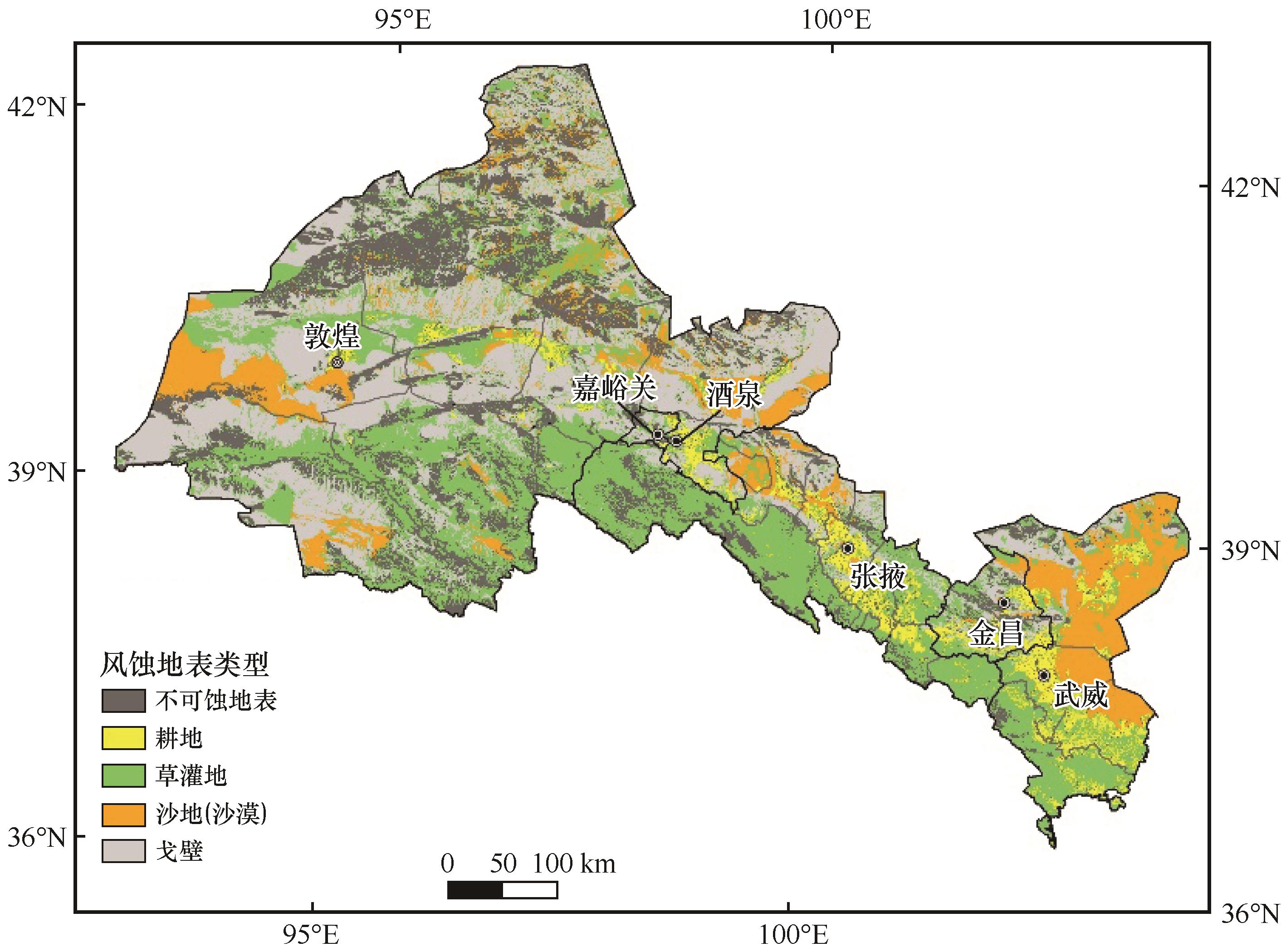
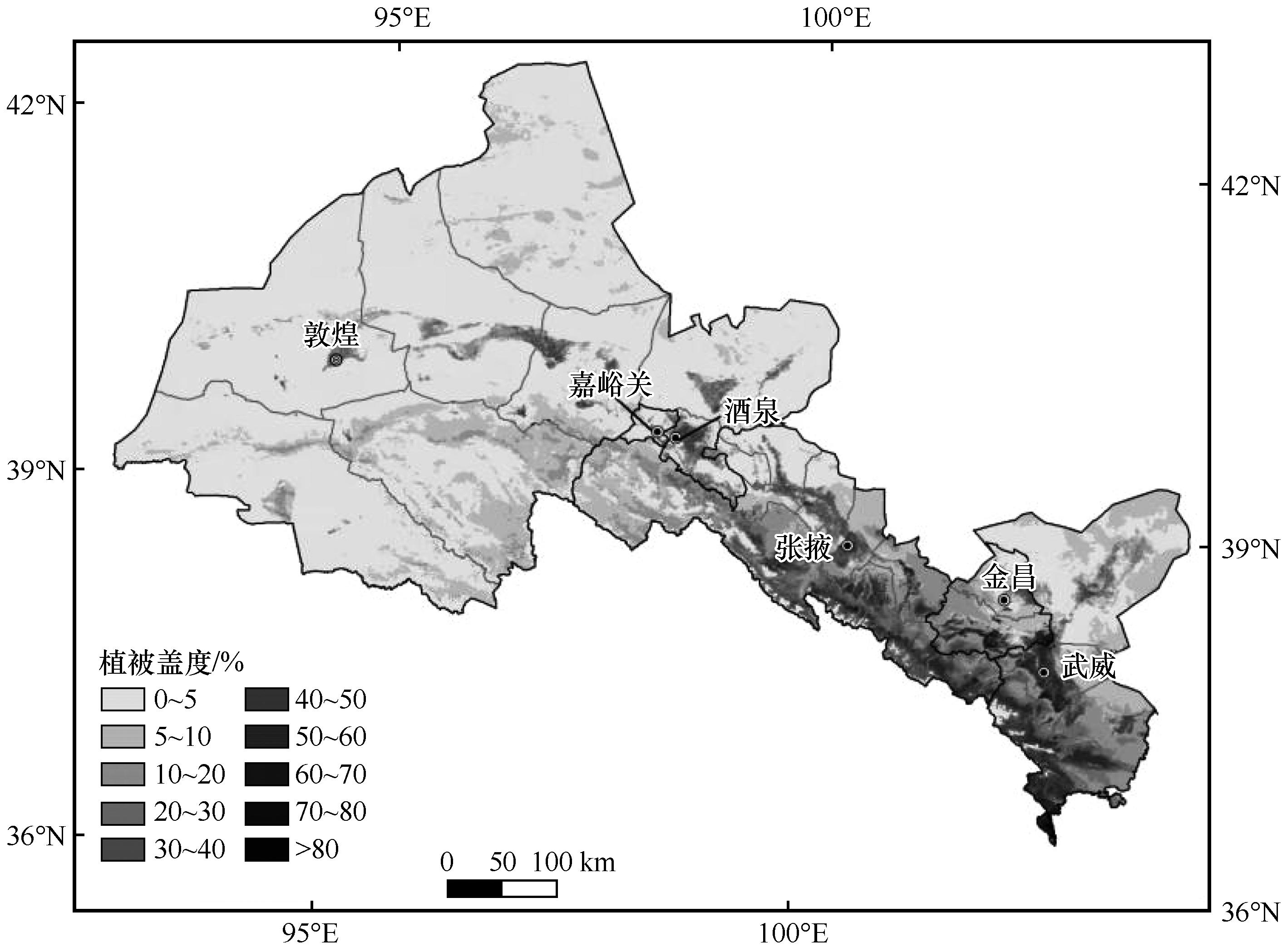
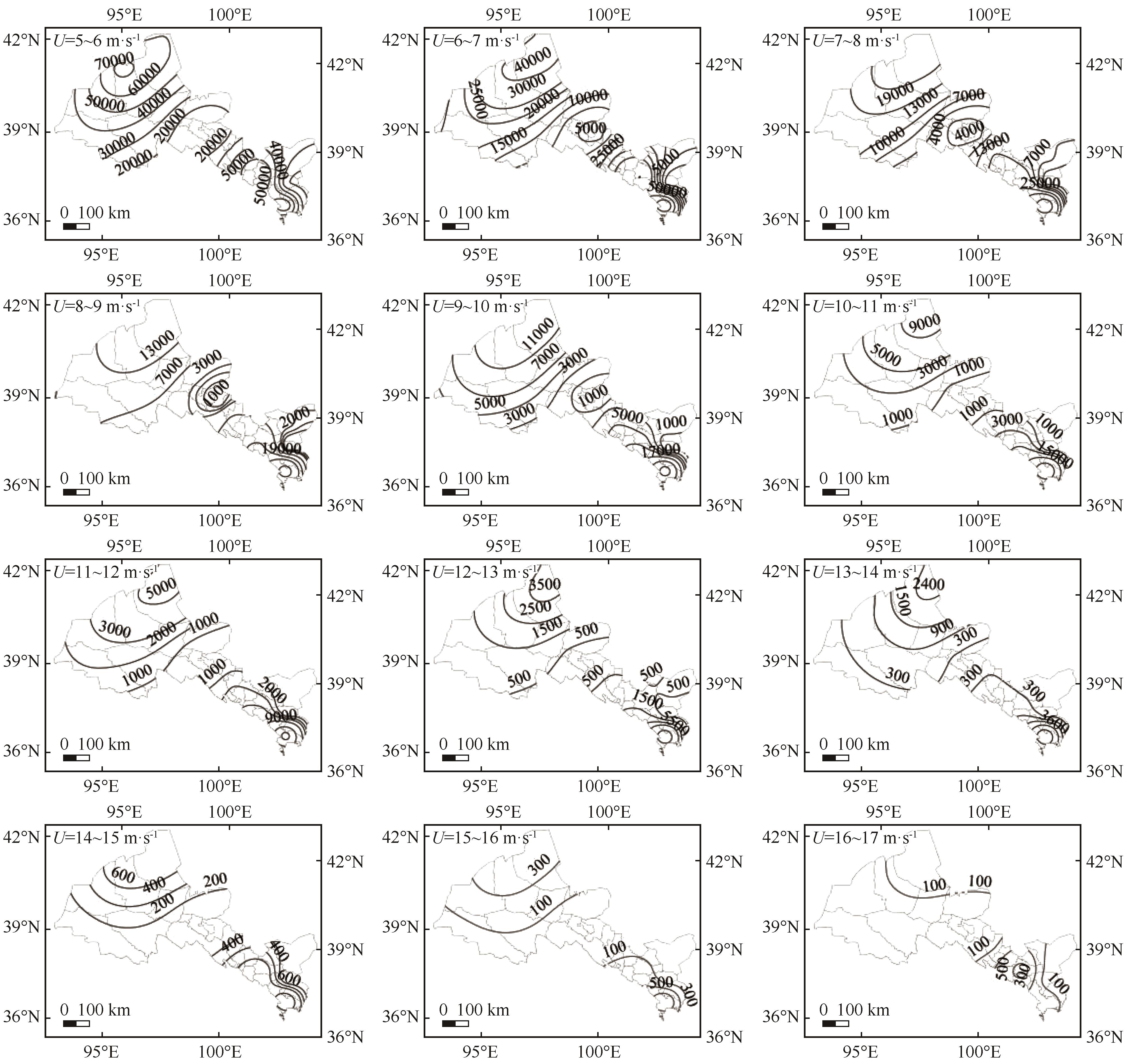
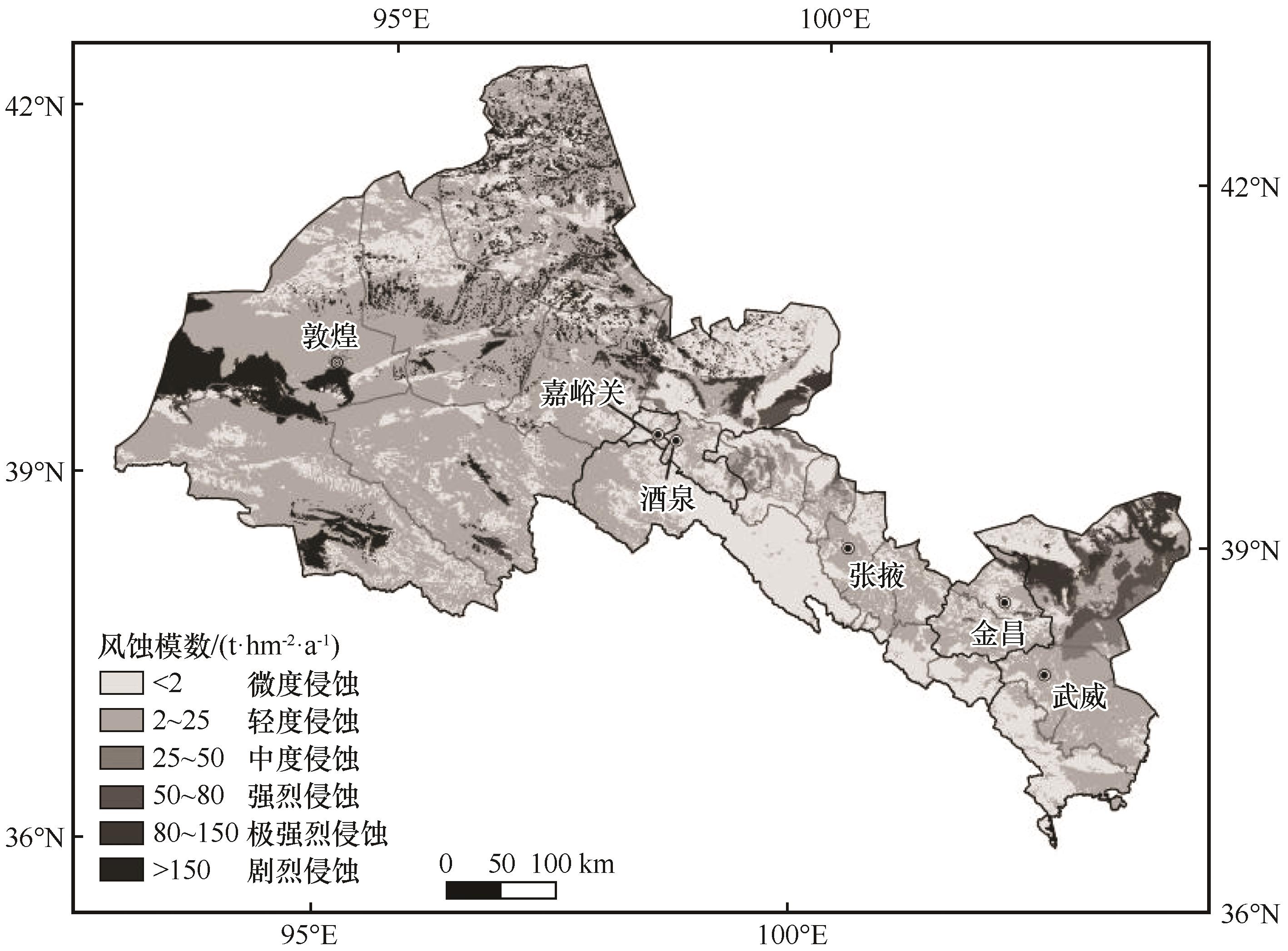
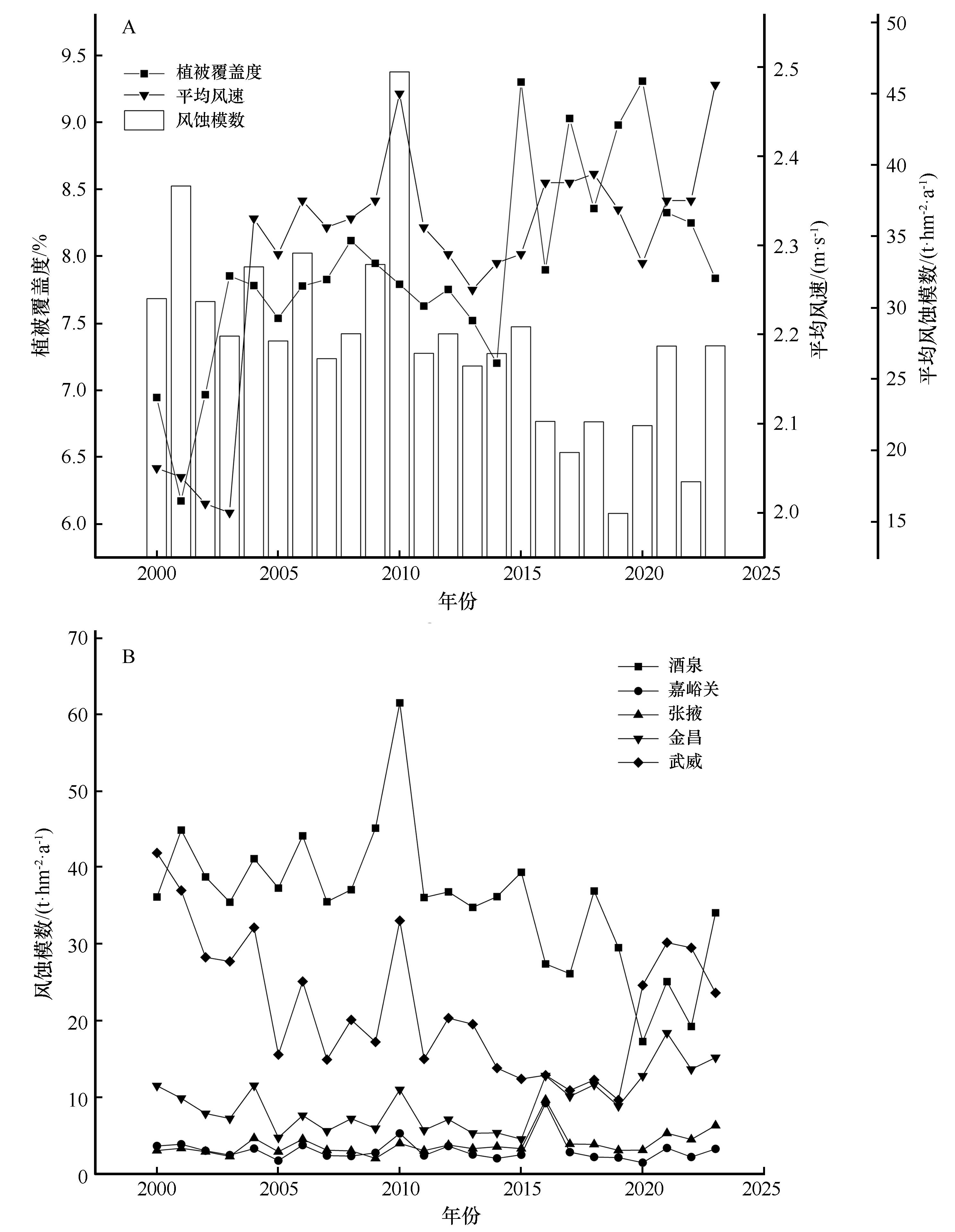
统计翔实的河西走廊土壤风蚀数据,可为政府部门制定风蚀防治战略提供科学依据。在第一次全国水利普查得到的草灌地风蚀模型的基础上,通过补充砾石覆盖因子,获得戈壁地表的土壤风蚀方程,从而改进了第一次全国水利普查风蚀模型。利用改进的风蚀模型,计算了河西走廊2000—2023年的土壤风蚀空间分布及年际变化。结果表明:河西走廊平均风蚀模数为27.74 t·hm-2·a-1,土壤风蚀空间差异显著。东南部和中部以微度和轻度风蚀为主;东北部的民勤绿洲及沙漠地区风蚀以中度-极强烈风蚀为主,极强烈风蚀区域面积达到3 218 km2;西部沙漠与戈壁镶嵌分布,土壤风蚀极度不均,剧烈侵蚀面积高达14 840 km2。2000—2023年风蚀模数总体呈波动下降趋势,2020年以来风蚀强度有所回升。2001年和2010年是这一时期内风蚀最强烈的年份,风蚀模数分别高达46.52 t·hm-2·a-1和38.52 t·hm-2·a-1,主要原因分别是低于常年的植被覆盖和超出常年的风力。

关键词: 河西走廊, 土壤风蚀, 风蚀模型

Abstract:

This study compiles detailed soil wind erosion statistics across the Hexi Corridor, providing a scientific foundation for municipal governments to formulate targeted wind erosion prevention strategies. By supplementing a gravel coverage factor to the wind erosion equation of grassland or shrub land, this paper obtained the soil wind erosion equation of the gobi surface, thereby improving the soil wind erosion model used in the first water resources census of China. Making use of the improved model, the spatial distribution and the inter-annual variation of soil wind erosion in the Hexi Corridor from 2000 to 2023 were investigated. The results show that the average wind erosion modulus in the Hexi Corridor was 27.74 t·hm-2·a-1, with significant spatial variation in soil wind erosion. The southeast and central regions are predominantly characterized by slight and mild wind erosion, while the Minqin oasis and desert areas in the northeast experience moderate to extremely intense soil wind erosion, with the area of extremely intense soil wind erosion reaching 3 218 km2. In the western deserts and gobi regions, where sand and gravel landscapes are interwoven, soil wind erosion exhibits extreme spatial heterogeneity, with the area of severe wind erosion reaching 14 840 km2. From 2000 to 2023, the wind erosion modulus generally showed a fluctuating downward trend, but wind erosion intensity has rebounded since 2020. During this period, the years 2001 and 2010 recorded the most severe wind erosion with the modulus of 46.52 t·hm-2·a-1 and 38.52 t·hm-2·a-1, respectively, which is primarily driven by the poorest vegetation coverage and the strongest wind force.

Key words: Hexi Corridor, soil wind erosion, soil wind erosion model

中图分类号: