img

官方微信

高级检索

中国沙漠 ›› 2026, Vol. 46 ›› Issue (2): 113-121.DOI: 10.7522/j.issn.1000-694X.2025.00155

• • 上一篇    

19952023年锡林浩特露天煤矿矿区植被绿度时空演变特征

赵美玲1(), 白宇1, 季达1, 范志睿1, 杨广鑫1, 陈丙昊2,3, 罗亚勇3()   

  1. 1.锡林郭勒盟蒙东矿业有限责任公司,内蒙古 锡林浩特 026000
    2.内蒙古大学 生态与环境学院,内蒙古 呼和浩特 010020
    3.中国科学院西北生态环境资源研究院 奈曼沙漠化研究站,甘肃 兰州 730000
  • 收稿日期:2025-08-12 修回日期:2025-10-21 出版日期:2026-03-20 发布日期:2026-04-13
  • 通讯作者: 罗亚勇
  • 作者简介:赵美玲(1987—),女,辽宁大连人,硕士,工程师,主要从事露天采矿技术与管理方面的工作。E-mail: 120069572@ceic.com
  • 基金资助:
    国家自然科学基金项目(42275132);中国科学院“西部之光”人才培养引进计划项目(E529050201);蒙东矿业科技项目(蒙东矿业〔2024〕254号)

Spatio-temporal evolution characteristics of vegetation greenness in open-pit coal mine area of Xilinhot from 1995 to 2023

Meiling Zhao1(), Yu Bai1, Da Ji1, Zhirui Fan1, Guangxin Yang1, Binghao Chen2,3, Yayong Luo3()   

  1. 1.Xilingol Mengdong Mining Co. ,Ltd. ,Xilinhot 026000,Inner Mongolia,China
    2.School of Ecology and Environment,Inner Mongolia University,Hohhot 010020,China
    3.Naiman Desertification Research Station,Northwest Institute of Eco-Environment and Resources,Chinese Academy of Sciences,Lanzhou 730000,China
  • Received:2025-08-12 Revised:2025-10-21 Online:2026-03-20 Published:2026-04-13
  • Contact: Yayong Luo

摘要:

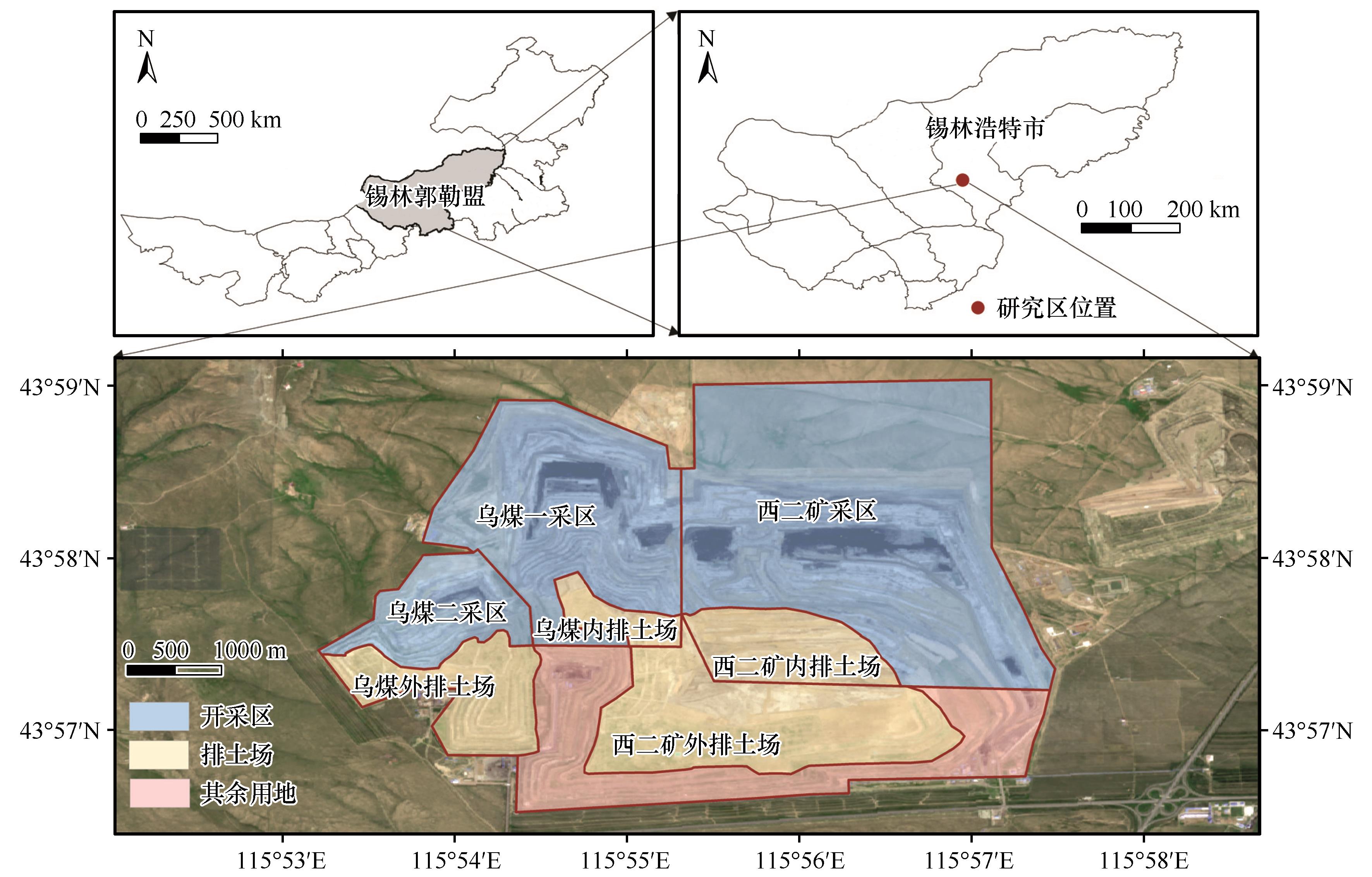
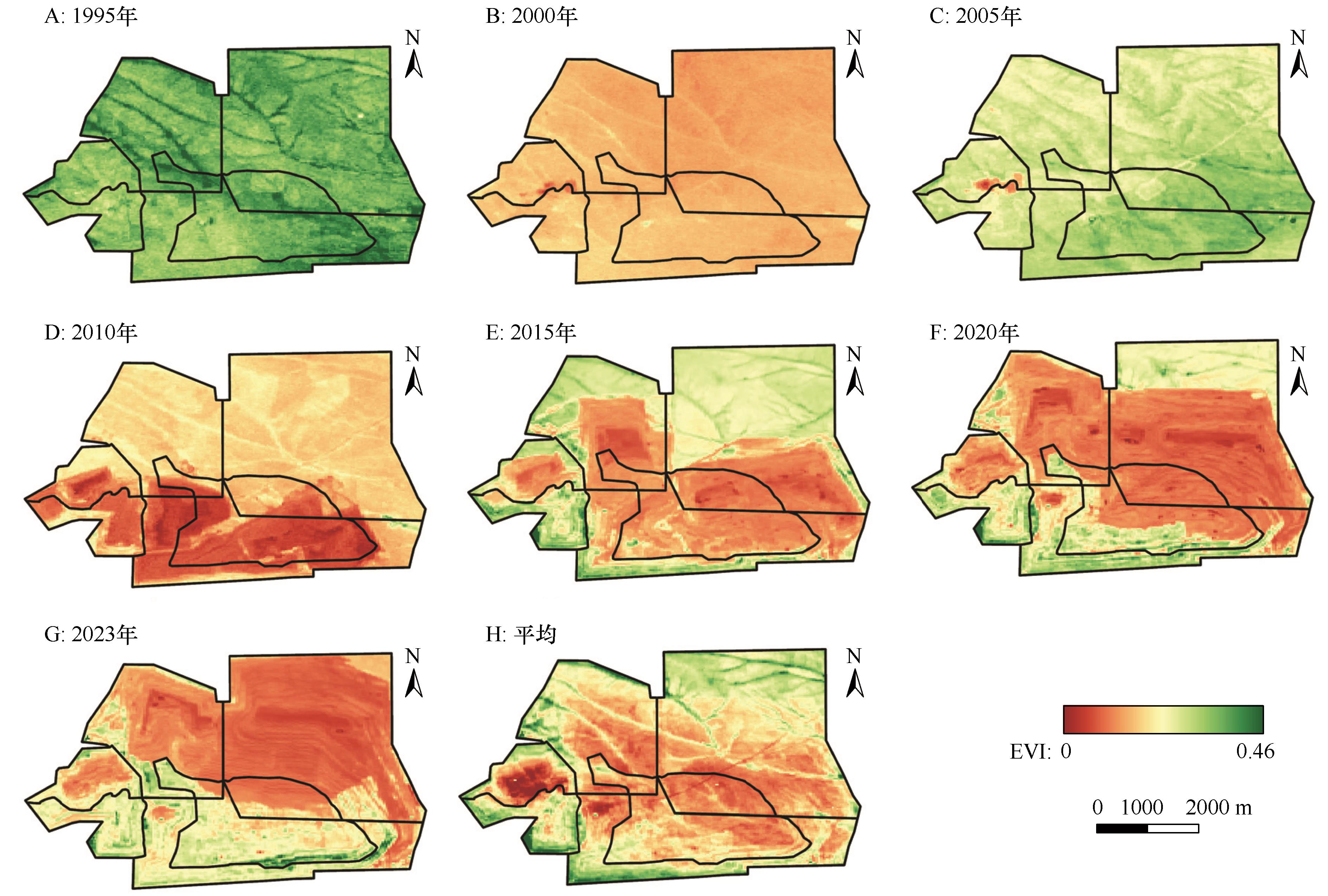
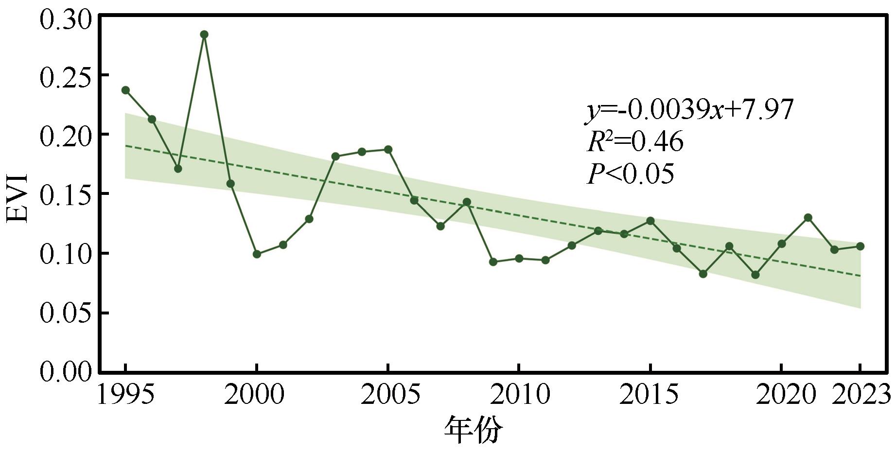
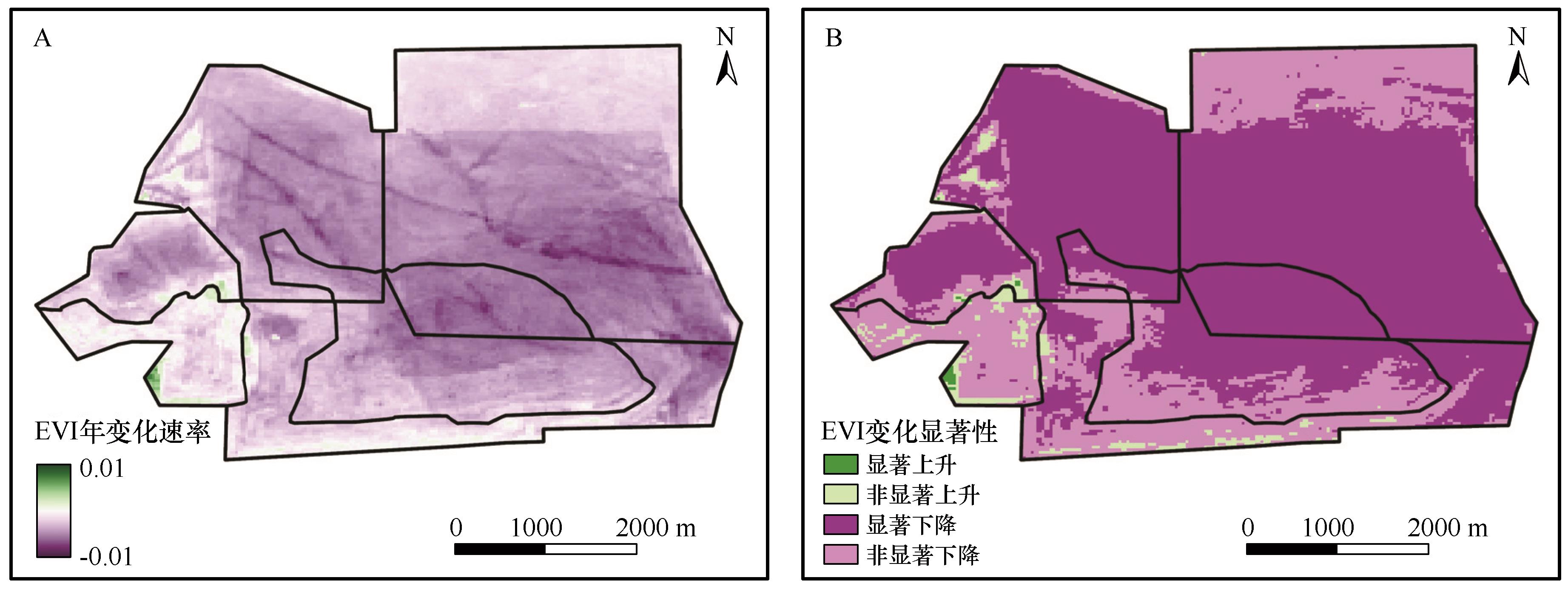
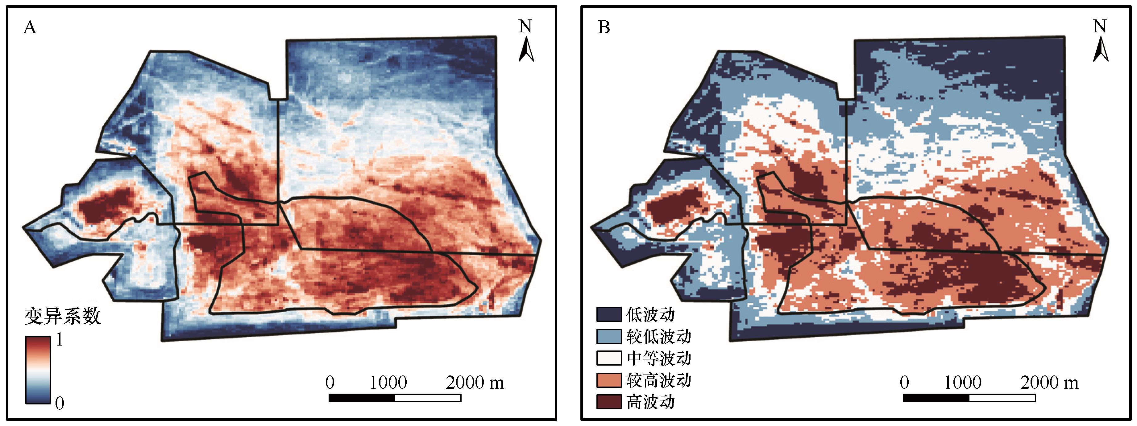
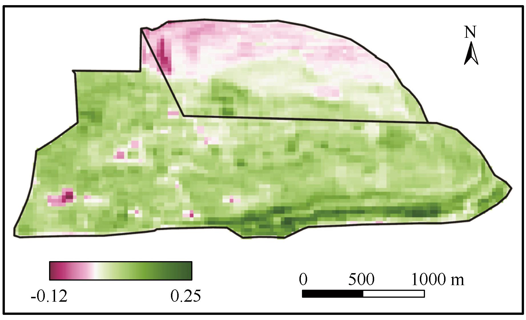
露天煤矿的开采活动及后续生态修复工程直接影响植被的生长状况与空间分布。开展矿区植被状况监测对于评估修复工程成效、指导后续生态治理具有重要意义。本研究选定锡林郭勒盟乌兰图嘎锗矿矿区与胜利西二号矿区作为研究区,利用Google Earth Engine云平台计算1995—2023年EVI时间序列数据,采用Sen+MK分析研究区植被绿度空间格局、时空演变趋势,运用变异系数分析研究区植被稳定性,基于生态修复工程实施前后EVI差值对生态修复效果进行评估。结果表明:(1)1995—2023年研究区EVI空间格局受矿区开采活动影响,呈现南部高、北部低的特征,低值区随露天开采范围向北扩张。(2)EVI整体呈下降趋势,29年间年均下降0.0039,2017年和2019年降至最低。空间上,77.7%区域下降,最大年降幅0.0089;22.3%区域上升,最大年上升为0.0072。(3)EVI稳定性差异显著:变异系数均值为0.44,范围为0.2~1.0,呈中部高、四周低格局。高波动区域占12.1%,较高波动区占24.6%。(4)生态修复工程成效明显,自2015年起实施修复工程,至2023年已有86.1%排土场区域恢复,13.9%区域仍退化,主要分布在采矿干扰带。

关键词: 露天矿区, 生态修复, 遥感监测, EVI

Abstract:

Open-pit coal mining activities and subsequent ecological restoration projects directly affect the growth and spatial distribution of vegetation. Monitoring vegetation conditions in mining areas is crucial for evaluating the effectiveness of restoration efforts and guiding future ecological management. In this study, the Wulantuga germanium open-pit mining area and the Shengli West No.2 open-pit coal mine in Xilingol League, Inner Mongolia, China were selected as the study area. Using the Google Earth Engine (GEE) cloud platform, we calculated the EVI time-series data from 1995 to 2023. The Sen's slope estimator and Mann-Kendall (MK) test were employed to analyze the spatial patterns and spatiotemporal evolution of vegetation greenness. The coefficient of variation was used to assess vegetation stability over the 29-year period, and the differences in EVI before and after ecological restoration were used to evaluate restoration effectiveness. The results show that:(1) From 1995 to 2023, the spatial pattern of EVI was significantly influenced by mining activities, evolving from a distribution of high in the south and low in the north, with low-value zones expanding northward along with the open-pit mining area. (2) Overall, EVI exhibited a decreasing trend, with an average annual decline rate of 0.0039, reaching the lowest levels in 2017 and 2019. Spatially, 77.7% of the area showed decline (maximum 0.0089), while 22.3% showed an increase (maximum 0.0072). (3) EVI stability varied significantly, with an average coefficient of variation of 0.44 (ranging from 0.2 to 1.0), displaying a pattern of high in the center and low on the periphery. Highly fluctuating areas accounted for 12.1%, and moderately fluctuating areas accounted for 24.6%. (4) Ecological restoration efforts achieved notable results: since their implementation in 2015, 86.1% of the dump areas have shown vegetation recovery by 2023, while 13.9% of areas, mainly the mining disturbance zones, remain degraded.

Key words: open-pit mining area, ecological restoration, remote sensing monitoring, EVI

中图分类号: