中国沙漠 ›› 2026, Vol. 46 ›› Issue (4): 160-174.DOI: 10.7522/j.issn.1000-694X.2026.00016
于静1( ), 武文硕1, 付铭2, 高亚敏1,3()
收稿日期:2025-11-14
修回日期:2026-03-03
出版日期:2026-07-20
发布日期:2026-08-27
通讯作者:
高亚敏
作者简介:于静(1991—),女,内蒙古通辽市人,工程师,主要从事气候变化、陆表蒸散以及干旱监测研究。E-mail:yjarhope@163.com
基金资助:
Jing Yu1(), Wenshuo Wu1, Ming Fu2, Yamin Gao1,3()
Received:2025-11-14
Revised:2026-03-03
Online:2026-07-20
Published:2026-08-27
Contact:
Yamin Gao
摘要:
作为中国防沙治沙的主战场,科尔沁沙地植被覆盖度(Fractional Vegetation Cover, FVC)的变化是评估区域生态治理成效的关键指标。本研究基于Google Earth Engine(GEE)平台,反演2000—2023年生长季FVC长时序数据集,综合运用Sen-MK趋势分析、变异指数、Hurst指数等方法,系统揭示FVC的时空演变、稳定性及未来趋势,进而通过偏相关分析、土地利用转移矩阵和冗余分析(RDA),定量辨析气候与人类活动的驱动作用。结果表明:(1)时间尺度,生长季FVC呈上升趋势,年均增长率为0.43%,等级结构显著优化,极高覆盖度占比从17.45%跃升至49.78%;空间尺度,FVC呈现高覆盖度广布、低覆盖度斑块交错格局,无显著方向性分异。(2)FVC稳定变化区域占比为47.89%,不稳定变化区域占比为44.13%,后者多呈斑块状分布于科尔沁沙地西部;Hurst指数显示,90.13%的区域未来变化与过去一致,其中63.28%的区域持续性极强(H >0.7),预示改善趋势将长期维持。(3)降水是主导气候因子,与FVC呈正相关的区域占74.05%(显著正相关占12.46%,P<0.05);人类活动呈双向驱动,其中裸地→草地/林地转化带来了显著的生态正向收益,而耕地→建设用地及草地→裸地转化则对局部植被生长有负向效应。冗余分析定量揭示人类活动是影响科尔沁沙地植被空间格局的核心驱动力,其对格局变化的解释贡献度达67.44%。本研究可为科尔沁沙地生态治理与干旱半干旱区植被动态监测提供科学依据与方法参考。
中图分类号:
于静, 武文硕, 付铭, 高亚敏. 科尔沁沙地植被覆盖度时空变化及成因[J]. 中国沙漠, 2026, 46(4): 160-174.
Jing Yu, Wenshuo Wu, Ming Fu, Yamin Gao. Spatiotemporal variation and causes of vegetation coverage in Horqin Sandy Land[J]. Journal of Desert Research, 2026, 46(4): 160-174.
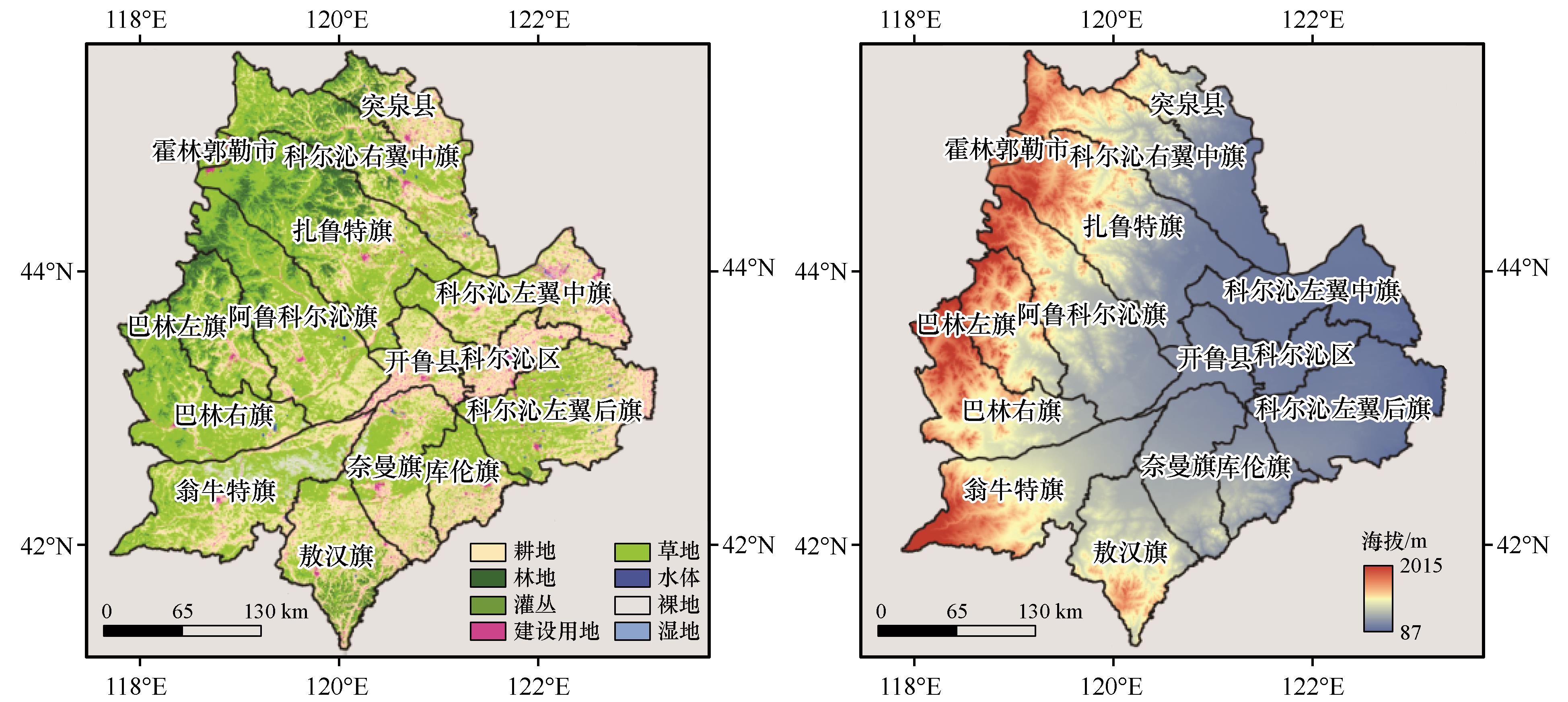
图1 研究区示意图注:基于自然资源部标准地图服务网站审图号GS(2024)0650号标准地图制作,底图边界无修改
Fig.1 Location of the study area
| Sen x | |Z| | 变化趋势 |
|---|---|---|
| Sen x >0 | |Z|>2.58 | 极显著上升 |
| 1.96<|Z|≤2.58 | 显著上升 | |
| |Z|≤1.96 | 不显著上升 | |
| Sen x =0 | |Z| | 无变化 |
| Sen x <0 | |Z|>2.58 | 极显著下降 |
| 1.96<|Z|≤2.58 | 显著下降 | |
| |Z|≤1.96 | 不显著下降 |
表1 Mann-Kendall检验趋势分类
Table 1 Mann-Kendall test trend categories
| Sen x | |Z| | 变化趋势 |
|---|---|---|
| Sen x >0 | |Z|>2.58 | 极显著上升 |
| 1.96<|Z|≤2.58 | 显著上升 | |
| |Z|≤1.96 | 不显著上升 | |
| Sen x =0 | |Z| | 无变化 |
| Sen x <0 | |Z|>2.58 | 极显著下降 |
| 1.96<|Z|≤2.58 | 显著下降 | |
| |Z|≤1.96 | 不显著下降 |
| 数据产品 | 空间分辨率 | 时间 | 数据网址 |
|---|---|---|---|
| 中国1 km分辨率逐月平均气温数据集 | 1 km | 2000—2023年 | https://www.tpdc.ac.cn/zh-hans/data/71ab4677-b66c-4fd1-a004-b2a541c4d5bf |
| 中国1 km分辨率逐月降水量数据集 | 1 km | 2000—2023年 | https://www.tpdc.ac.cn/zh-hans/data/faae7605-a0f2-4d18-b28f-5cee413766a2 |
| 中国1 km逐月潜在蒸散发数据集 | 1 km | 2000—2023年 | https://www.tpdc.ac.cn/zh-hans/data/8b11da09-1a40-4014-bd3d-2b86e6dccad4 |
| 植被数据 | 500 m | 2000—2023年 | https://doi.org/10.5067/MODIS/MOD09GA.061 |
| 中国年度土地覆盖数据集CLCD | 30 m | 2000、2005、2010、2015、2020、2023年 | http://doi.org/10.5281/zenodo.4417809 |
表2 数据来源
Table 2 Data source
| 数据产品 | 空间分辨率 | 时间 | 数据网址 |
|---|---|---|---|
| 中国1 km分辨率逐月平均气温数据集 | 1 km | 2000—2023年 | https://www.tpdc.ac.cn/zh-hans/data/71ab4677-b66c-4fd1-a004-b2a541c4d5bf |
| 中国1 km分辨率逐月降水量数据集 | 1 km | 2000—2023年 | https://www.tpdc.ac.cn/zh-hans/data/faae7605-a0f2-4d18-b28f-5cee413766a2 |
| 中国1 km逐月潜在蒸散发数据集 | 1 km | 2000—2023年 | https://www.tpdc.ac.cn/zh-hans/data/8b11da09-1a40-4014-bd3d-2b86e6dccad4 |
| 植被数据 | 500 m | 2000—2023年 | https://doi.org/10.5067/MODIS/MOD09GA.061 |
| 中国年度土地覆盖数据集CLCD | 30 m | 2000、2005、2010、2015、2020、2023年 | http://doi.org/10.5281/zenodo.4417809 |
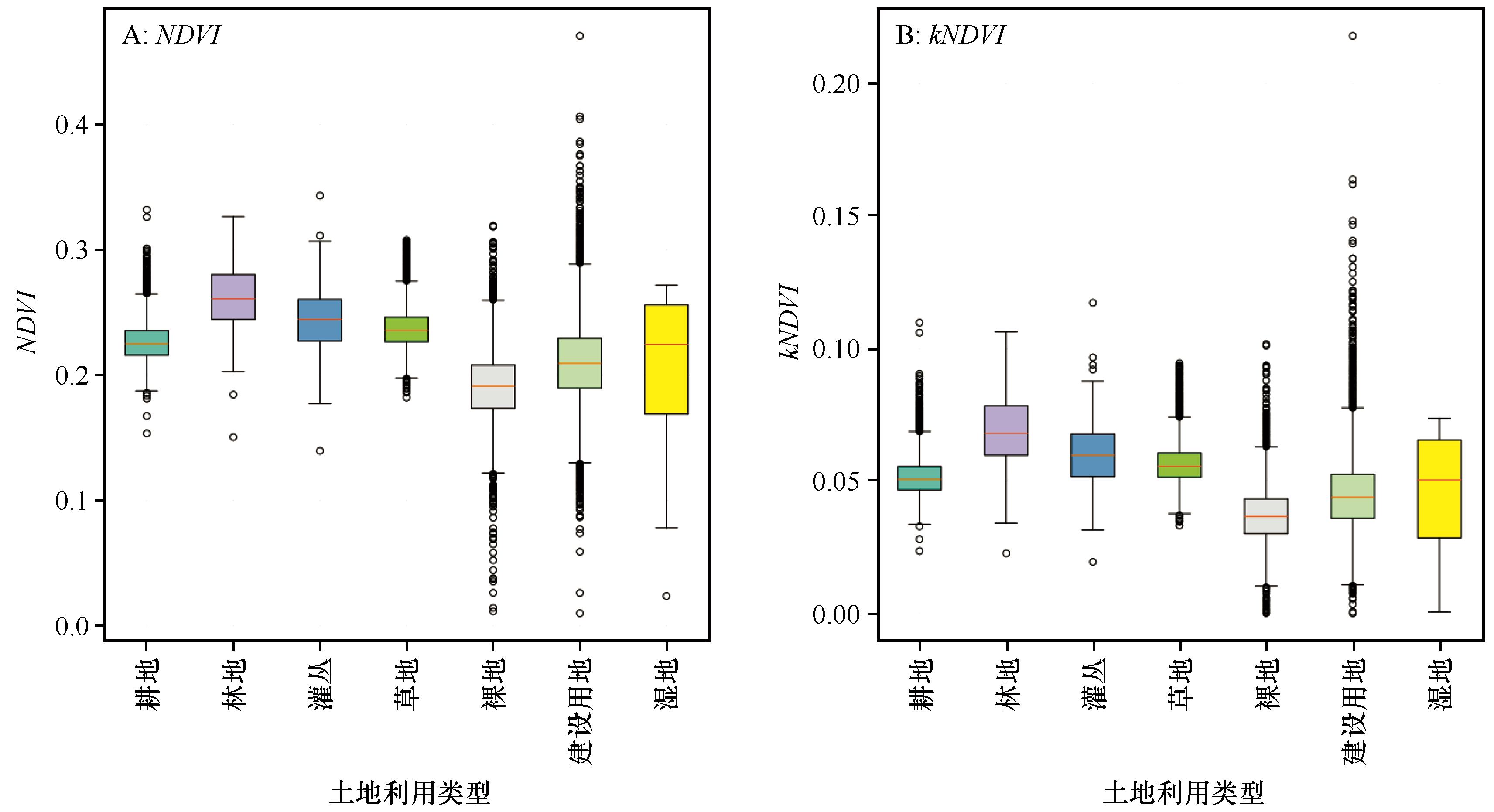
图2 NDVI与kNDVI箱线图
Fig.2 Box plot of NDVI and kNDVI
| FVC等级 | 2000年 | 2023年 | 2000—2023年 | |||
|---|---|---|---|---|---|---|
| 面积/km2 | 占比/% | 面积/km2 | 占比/% | 面积变化/km2 | 占比变化/% | |
| 极低覆盖度 | 1 642 | 1.30 | 537 | 0.40 | -1 105 | -0.90 |
| 低覆盖度 | 20 751 | 16.50 | 5 603 | 4.40 | -15 149 | -12.10 |
| 中覆盖度 | 46 253 | 36.77 | 19 472 | 15.48 | -26 781 | -21.29 |
| 高覆盖度 | 35 193 | 27.98 | 37 660 | 29.94 | 2 467 | 1.96 |
| 极高覆盖度 | 21 952 | 17.45 | 62 625 | 49.78 | 40 673 | 32.33 |
表3 2000—2023年科尔沁沙地 FVC 动态变化
Table 3 Dynamic changes in FVC of the Horqin Sand Land from 2000 to 2023
| FVC等级 | 2000年 | 2023年 | 2000—2023年 | |||
|---|---|---|---|---|---|---|
| 面积/km2 | 占比/% | 面积/km2 | 占比/% | 面积变化/km2 | 占比变化/% | |
| 极低覆盖度 | 1 642 | 1.30 | 537 | 0.40 | -1 105 | -0.90 |
| 低覆盖度 | 20 751 | 16.50 | 5 603 | 4.40 | -15 149 | -12.10 |
| 中覆盖度 | 46 253 | 36.77 | 19 472 | 15.48 | -26 781 | -21.29 |
| 高覆盖度 | 35 193 | 27.98 | 37 660 | 29.94 | 2 467 | 1.96 |
| 极高覆盖度 | 21 952 | 17.45 | 62 625 | 49.78 | 40 673 | 32.33 |
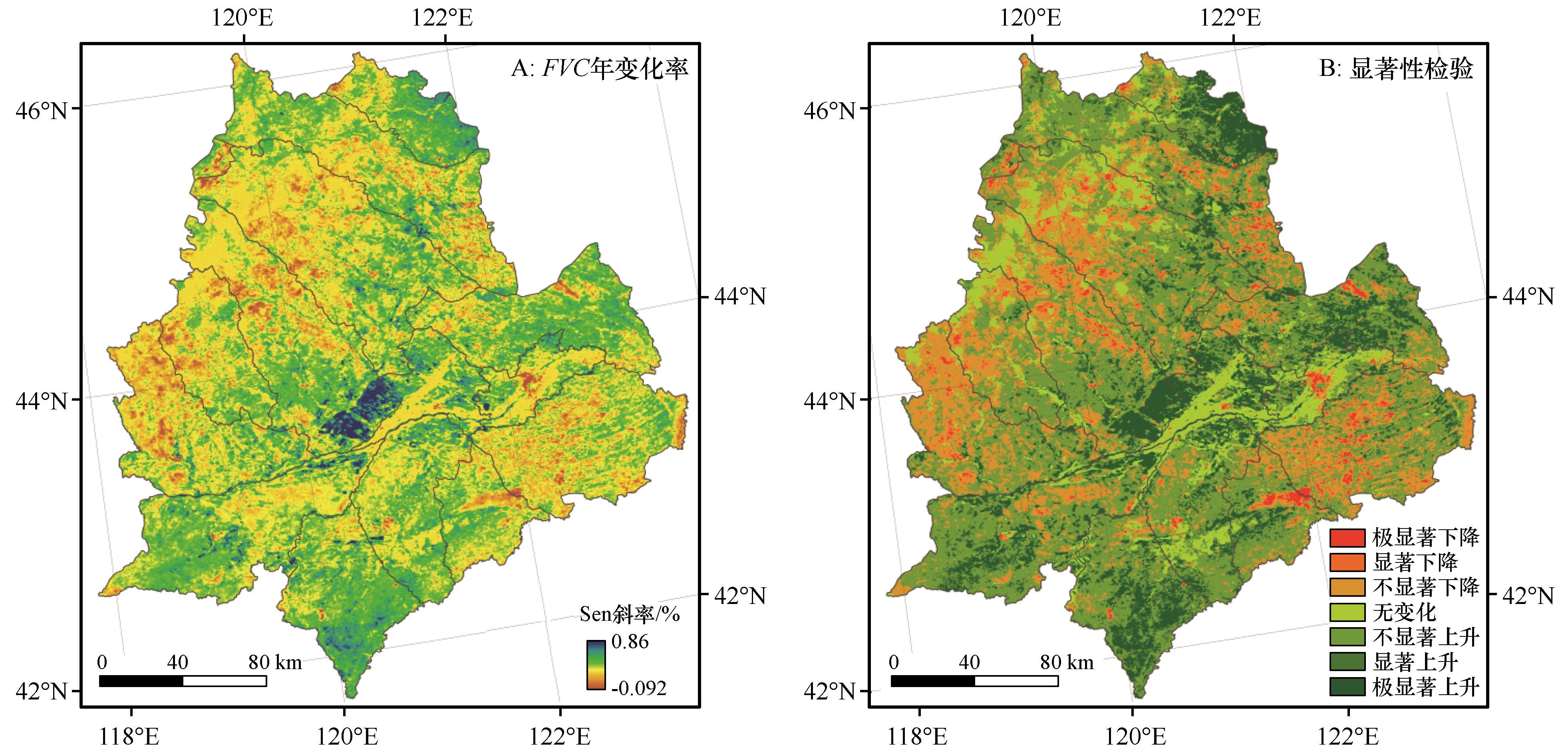
图3 2000—2023年FVC年变化率空间分布及显著性检验注:基于自然资源部标准地图服务网站审图号GS(2024)0650号标准地图制作,底图边界无修改
Fig.3 Trend slope of FVC change spatial distribution and significance test from 2000 to 2023
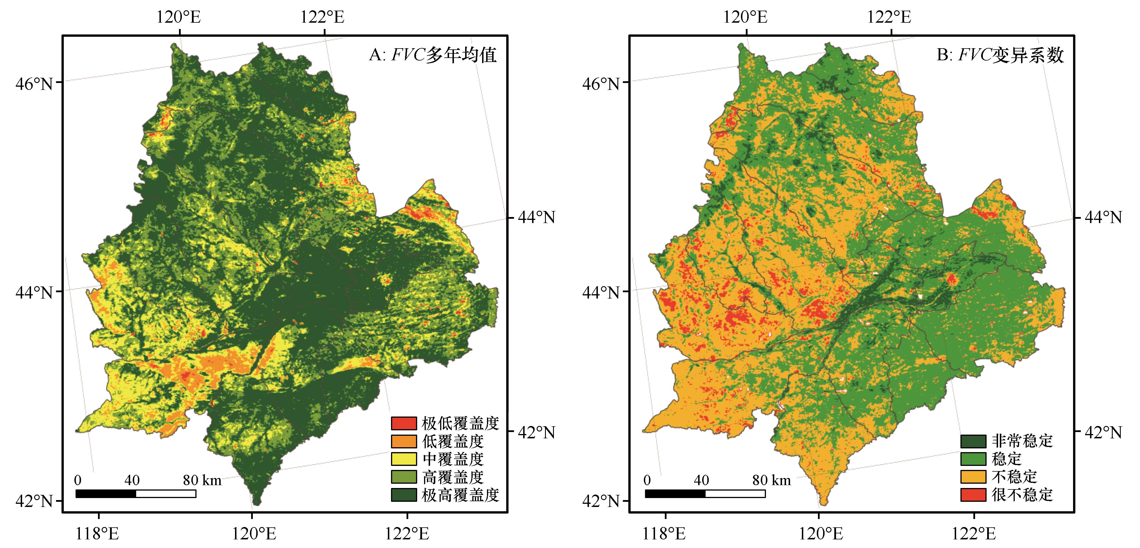
图4 科尔沁沙地FVC多年均值及变异系数分布注:基于自然资源部标准地图服务网站审图号GS(2024)0650号标准地图制作,底图边界无修改
Fig.4 The distribution of the annual mean and the coefficient of variation of FVC
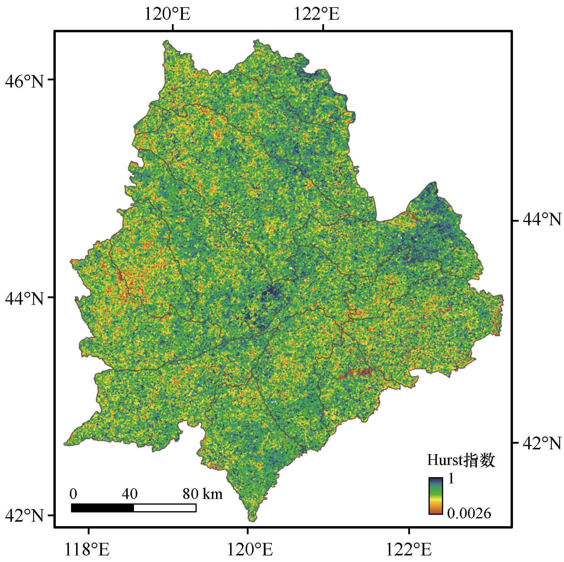
图5 Hurst指数空间分布注:基于自然资源部标准地图服务网站审图号GS(2024)0650号标准地图制作,底图边界无修改
Fig.5 Spatial distribution of the Hurst index
| 前期类型 | 后期类型 | 2000—2005年 | 2005—2010年 | 2010—2015年 | 2015—2020年 | 2020—2023年 | 2000—2023年 |
|---|---|---|---|---|---|---|---|
| 耕地 | 耕地 | 40 826 | 40 165 | 42 595 | 43 344 | 44 427 | 38 004 |
| 建设用地 | 107 | 151 | 161 | 126 | 170 | 807 | |
| 草地 | 8 293 | 5 870 | 3 766 | 6 607 | 1 536 | 10 087 | |
| 林地 | 25 | 26 | 65 | 44 | 126 | 170 | |
| 林地 | 林地 | 7 302 | 7 668 | 7 785 | 7 990 | 8 200 | 7 191 |
| 耕地 | 56 | 30 | 42 | 51 | 36 | 94 | |
| 灌丛 | 0 | 0 | 0 | 0 | 10 | 9 | |
| 建设用地 | 建设用地 | 2 179 | 2 360 | 2 735 | 3 173 | 3 424 | 2 168 |
| 耕地 | 0 | 0 | 0 | 0 | 11 | 2 | |
| 裸地 | 草地 | 1 817 | 496 | 874 | 816 | 933 | 3 032 |
| 裸地 | 3 770 | 3 598 | 3 757 | 3 422 | 3 039 | 2 238 |
表4 2000—2023年科尔沁沙地核心地类多期土地利用类型转移矩阵 (km2)
Table 4 Multi-period land use transition matrix of core land categories from 2000 to 2023 in Horqin Sandy Land
| 前期类型 | 后期类型 | 2000—2005年 | 2005—2010年 | 2010—2015年 | 2015—2020年 | 2020—2023年 | 2000—2023年 |
|---|---|---|---|---|---|---|---|
| 耕地 | 耕地 | 40 826 | 40 165 | 42 595 | 43 344 | 44 427 | 38 004 |
| 建设用地 | 107 | 151 | 161 | 126 | 170 | 807 | |
| 草地 | 8 293 | 5 870 | 3 766 | 6 607 | 1 536 | 10 087 | |
| 林地 | 25 | 26 | 65 | 44 | 126 | 170 | |
| 林地 | 林地 | 7 302 | 7 668 | 7 785 | 7 990 | 8 200 | 7 191 |
| 耕地 | 56 | 30 | 42 | 51 | 36 | 94 | |
| 灌丛 | 0 | 0 | 0 | 0 | 10 | 9 | |
| 建设用地 | 建设用地 | 2 179 | 2 360 | 2 735 | 3 173 | 3 424 | 2 168 |
| 耕地 | 0 | 0 | 0 | 0 | 11 | 2 | |
| 裸地 | 草地 | 1 817 | 496 | 874 | 816 | 933 | 3 032 |
| 裸地 | 3 770 | 3 598 | 3 757 | 3 422 | 3 039 | 2 238 |
| 时间 | 正向贡献总和/km2 | 负向贡献总和/km2 | 净生态贡献/km2 | 正向贡献占比/% |
|---|---|---|---|---|
| 2000—2005年 | 85 621 | -42 350 | 43 270 | 66.8 |
| 2005—2010年 | 52 311 | -58 761 | -6 450 | 47.0 |
| 2010—2015年 | 68 920 | -45 121 | 23 801 | 60.3 |
| 2015—2020年 | 75 641 | -38 250 | 37 391 | 66.5 |
| 2020—2023年 | 92 581 | -29 630 | 62 951 | 75.8 |
表5 2000—2023年科尔沁沙地多时段植被覆盖度生态贡献统计
Table 5 Ecological contribution of vegetation cover in Horqin Sandy Land in different periods from 2000 to 2023
| 时间 | 正向贡献总和/km2 | 负向贡献总和/km2 | 净生态贡献/km2 | 正向贡献占比/% |
|---|---|---|---|---|
| 2000—2005年 | 85 621 | -42 350 | 43 270 | 66.8 |
| 2005—2010年 | 52 311 | -58 761 | -6 450 | 47.0 |
| 2010—2015年 | 68 920 | -45 121 | 23 801 | 60.3 |
| 2015—2020年 | 75 641 | -38 250 | 37 391 | 66.5 |
| 2020—2023年 | 92 581 | -29 630 | 62 951 | 75.8 |
| 转移类型 | 累计转移面积/km2 | 平均ΔFVC/% | 累计生态贡献/km2 | 贡献占比/% |
|---|---|---|---|---|
| 裸地→草地 | 3 032 | +25.00 | +75 811 | 56.1 |
| 裸地→林地 | 896 | +40.50 | +36 293 | 26.8 |
| 耕地→建设用地 | 807 | -58.70 | -47 362 | 74.6 |
| 草地→裸地 | 522 | -30.20 | -15 758 | 25.0 |
表6 科尔沁沙地核心转移类型累计生态贡献
Table 6 Cumulative ecological contribution of core transfer types in Horqin Sandy Land
| 转移类型 | 累计转移面积/km2 | 平均ΔFVC/% | 累计生态贡献/km2 | 贡献占比/% |
|---|---|---|---|---|
| 裸地→草地 | 3 032 | +25.00 | +75 811 | 56.1 |
| 裸地→林地 | 896 | +40.50 | +36 293 | 26.8 |
| 耕地→建设用地 | 807 | -58.70 | -47 362 | 74.6 |
| 草地→裸地 | 522 | -30.20 | -15 758 | 25.0 |
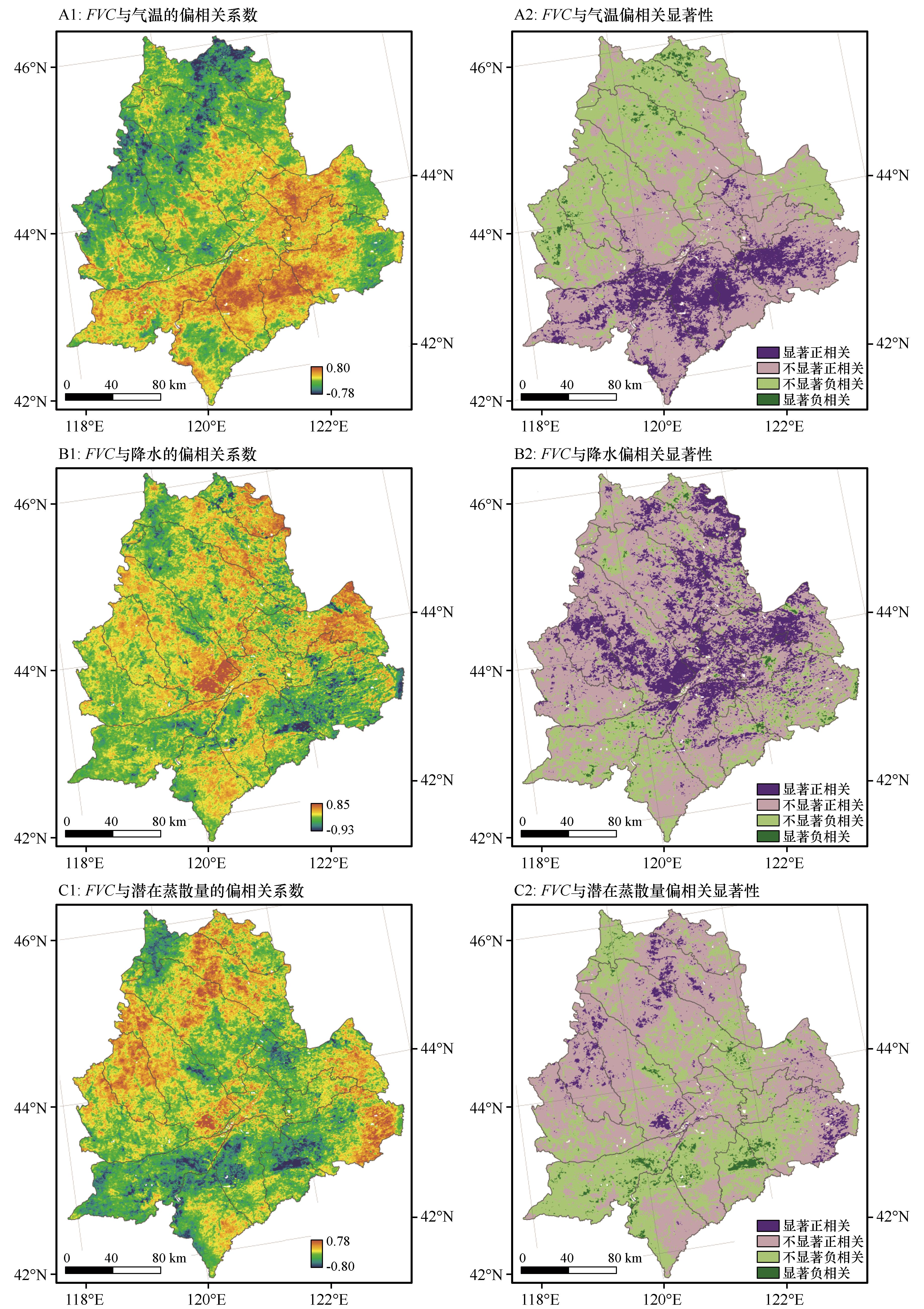
图6 科尔沁沙地FVC与气温、降水、潜在蒸散的偏相关系数及其显著性注:基于自然资源部标准地图服务网站审图号GS(2024)0650号标准地图制作,底图边界无修改
Fig.6 Partial correlation coefficients and their significance between temperature, precipitation, potential evapotranspiration and FVC
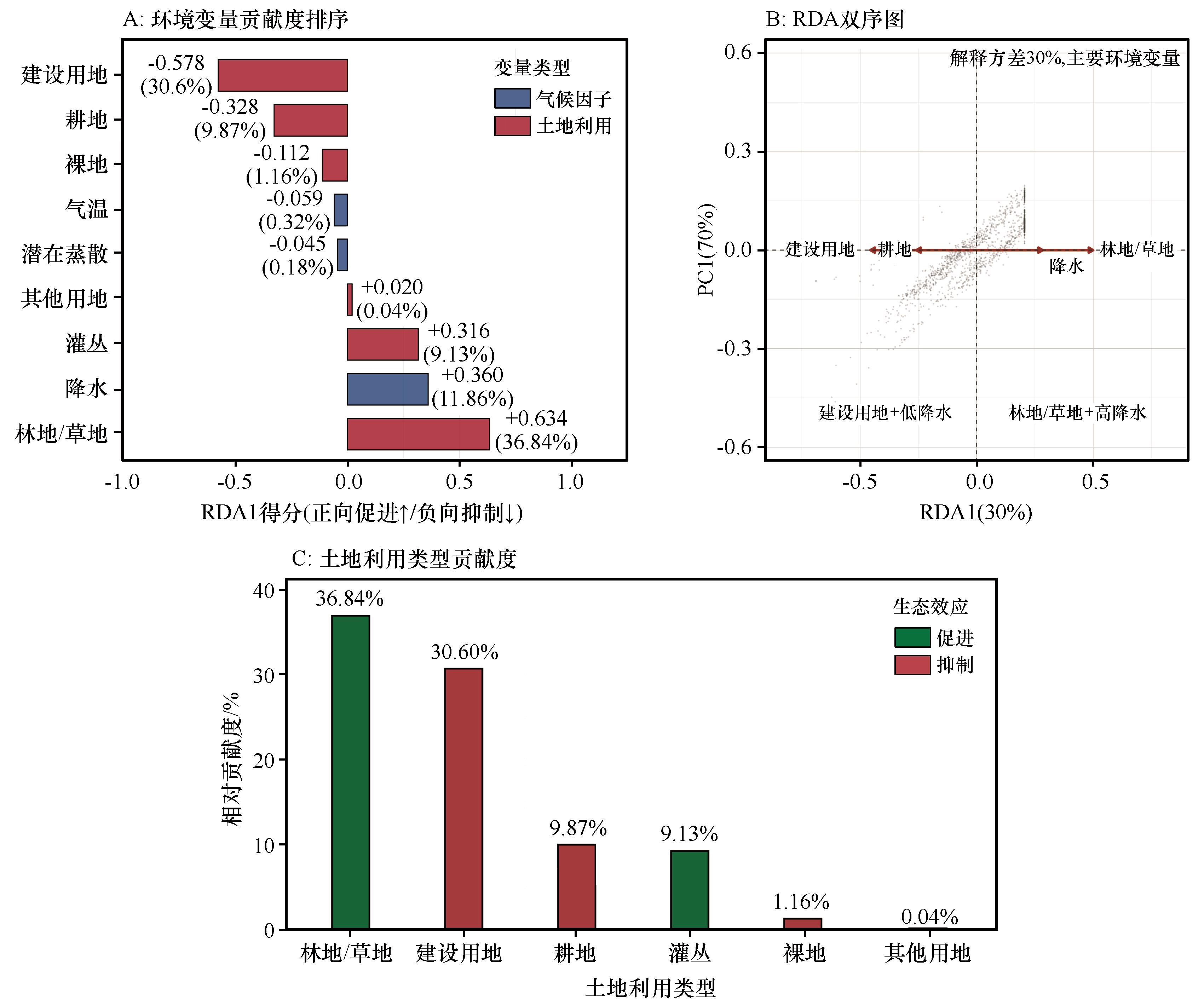
图7 科尔沁沙地植被覆盖度驱动因子冗余分析
Fig.7 Analysis results of redundancy of vegetation coverage drivers in Horqin Sandy Land
| [1] | 姜志伟,杨智博,杨清,等.2000-2022年库布齐沙漠植被覆盖度时空变化及其驱动因子[J].中国沙漠,2025,45(5):124-133. |
| [2] | Hou L F, Li L, Chen R F,et al. Vegetation dynamics:modeling,mechanisms,and emergent properties[J].Physics Reports,2025,1145:1-87. |
| [3] | 颜明,贺莉,王随继,等.基于NDVI的1982-2012年黄河流域多时间尺度植被覆盖变化[J].中国水土保持科学,2018,16(3):86-94. |
| [4] | Kumar D, Pfeiffer M, Gaillard C,et al.Misinterpretation of Asian savannas as degraded forest can mislead management and conservation policy under climate change.Biological Conservation,2020,241,108293. |
| [5] | 于静,高亚敏,付铭.科尔沁草原NDVI时空变化特征及其对气候的响应[J].中国草地学报,2020,42(6):82-90. |
| [6] | 武金洲,郑晓,高添,等.三北防护林体系建设工程对科尔沁沙地社会经济影响的定量分析[J].生态学杂志,2020,39(11):3567-3575. |
| [7] | 张慧龙,杨秀春,杨东,等.2000-2020年内蒙古草地植被覆盖度时空变化及趋势预测[J].草业学报,2023,32(8):1-13. |
| [8] | 白舒婷,王珊,迟文峰,等.2000-2023年科尔沁沙地植被NDVI时空动态及其对气候变化和人类活动的响应[J].干旱区资源与环境,2025,39(7):74-83. |
| [9] | Li M Y, Liu T X, Luo Y Y,et al.Fractional vegetation coverage downscaling inversion method based on Land Remote-Sensing Satellite (System,Landsat-8) and polarization decomposition of Radarsat-2[J].International Journal of Remote Sensing,2021,42(9):3255-3276. |
| [10] | Huang F, Wang P, Liu X N.Monitoring vegetation dynamics in Horqin Sandy Land from SPOT Vegetation time series imagery[C]//The International Archives of the Photogrammetry,Remote Sensing and Spatial Information Sciences.Beijing,China.2008:915-920. |
| [11] | 樊雪丰,孙新龙,张迎杰.阿鲁科尔沁旗植被覆盖度时空变化及气象原因[J].草原与草业,2024,36(1):14-18. |
| [12] | 马龙,王静茹,刘廷玺,等.2000-2012年科尔沁沙地植被与气候因子间的响应关系[J].农业机械学报,2016,47(4):162-172. |
| [13] | 崔珍珍,马超,陈登魁.1982-2015年科尔沁沙地植被时空变化及气候响应[J].干旱区研究,2021,38(2):536-544. |
| [14] | 陈效逑,王恒.1982-2003年内蒙古植被带和植被覆盖度的时空变化[J].地理学报,2009,64(1):84-94. |
| [15] | 卜凡蕊,刘颖,邹学勇.中国东部典型沙地植被覆盖度对降水变化的响应[J].中国沙漠,2023,43(3):9-20. |
| [16] | 沈贝贝,魏一博,马磊超,等.内蒙古草原植被覆盖度时空格局变化及驱动因素分析[J].农业工程学报,2022,38(12):118-126. |
| [17] | 张亦然,刘廷玺,童新,等.基于多源遥感和机器学习方法的科尔沁沙地植被覆盖度反演[J].中国沙漠,2022,42(3):187-195. |
| [18] | 高亚敏,于静,萨日娜,等.通辽市植被生态质量变化分析[J].内蒙古气象,2022(1):7-11. |
| [19] | 杨柳,闫峰,王艳姣.科尔沁和浑善达克沙地植被覆盖度时空变化及驱动力[J].林业科学,2025,61(11):70-79. |
| [20] | 于世勇,孙志超,慈雪伦,等.基于网格化的科尔沁沙地植被覆盖变化及驱动力分析[J].林草资源研究,2025(3):119-126. |
| [21] | 巢妍,梁丽娥,高乐凡,等.基于Google Earth Engine的黄土高原核归一化植被指数动态演变及其驱动因素[J].生态学报,2026,46(2):846-860. |
| [22] | 魏泽锋,官云兰,王淑婷,等.基于KNDVI的塔里木河流域植被覆盖时空变化与归因分析[J].环境科学,2025,46(12):7853-7864. |
| [23] | 王子昊,王冰,张秋良,等.基于KNDVI的大兴安岭生态功能区植被覆盖变化时空特征及驱动力分析[J]. 环境科学,2025,46(5):3021-3032. |
| [24] | 吴广霞,刘绥华,邓玲玲,等.基于KNDVI的贵州省植被时空变化及其驱动分析[J].水土保持研究,2025,3(3):222-230. |
| [25] | 魏光普,张文君,朱治衡,等.基于kNDVI的内蒙古自治区2004-2023年植被覆盖度时空变化及气候驱动因子[J].林业科学,2025,61(11):80-91. |
| [26] | Fan Q, Zhang L, Wu H,et al.Vegetation dynamics and driving mechanisms in the Northwest Desert zone based on long-term kNDVI data [J].Ecological Frontiers,2025,45 (4):836-848. |
| [27] | He L, Yuan Y, He Z,et al.Spatiotemporal variations of vegetation NPP based on GF-SG and KNDVI and its response to climate change and human activities:a case study of the Zoigê Plateau [J].Forests,2024,16 (1):32-32. |
| [28] | 张媛媛,曹亚楠,牛犇,等.基于kNDVI的藏北高原高寒草地植被覆盖变化及驱动力分析[J].草业科学,2025,42(11):2712-2726. |
| [29] | 李爱敏,颜培霞,汤洪震,等.基于多维度生态特征耦合的科尔沁沙地生态系统功能分区研究[J/OL].中国沙漠,2026,46(4):1-12[2026-03-25].. |
| [30] | 李玉强,王旭洋,郑成卓,等.科尔沁沙地防沙治沙实践与生态可持续修复浅议[J].中国沙漠,2024,44(4):302-314. |
| [31] | 张继平,常学礼,蔡明玉,等.土地利用类型变化对沙漠化过程的影响:以科尔沁沙地为例[J].干旱区研究,2009,26(1):39-44. |
| [32] | 刘二燕,赵媛媛,周蝶,等.科尔沁-浑善达克沙地2000-2020年土地沙化时空变化格局[J]中国沙漠,2024,44(4):46-56. |
| [33] | 周得龙,王永芳,郭恩亮,等.科尔沁沙地生境质量演变与预测[J].中国沙漠,2025,45(4):211-226. |
| [34] | 魏丰良,刘廷玺,张圣微,等.科尔沁沙地植被覆盖变化及其与气候因子的关系研究[J].水土保持研究,2012,19(3):254-258. |
| [35] | Vermote E, Wolfe R.MODIS/Terra Surface Reflectance Daily L2G Global 1 km and 500 m SIN Grid V061[DS].NASA Land Processes Distributed Active Archive Center.https://lpdaac.usgs.gov/doi,2021.doi:10.5067/MODIS/MOD09GA.061 . |
| [36] | Camps-Valls G, Campos-Taberner M, Moreno-Martínez Á,et al.A unified vegetation index for quantifying the terrestrial biosphere[J].Science Advances,2021,7(9):eabc7447. |
| [37] | Xu M, Guo B, Zhang R.A novel approach to detecting the salinization of the Yellow River Delta using a Kernel normalized difference vegetation index and a feature space model[J].Sustainability,2024,16(6):2560. |
| [38] | 彭守璋.中国1 km分辨率逐月平均气温数据集(1901—2024)[DS].国家青藏高原科学数据中心.http://data.tpdc.ac.cn/doi,2019,doi:10.11888/Meteoro.tpdc.270961 . |
| [39] | 彭守璋.中国1 km分辨率逐月降水量数据集(1901—2024)[DS].国家青藏高原科学数据中心.http://data.tpdc.ac.cn/doi,2020,doi:10.5281/zenodo.3114194 . |
| [40] | 彭守璋.中国1 km逐月潜在蒸散发数据集(1901—2024)[DS].国家青藏高原科学数据中心.http://data.tpdc.ac.cn/doi,2022,doi:10.11866/db.loess.2021.001 . |
| [41] | Ma Y Y, Wang W Y, Jin S K,et al.Spatiotemporal variation of LAI in different vegetation types and its response to climate change in China from 2001 to 2020[J].Ecological Indicators,2023,156:111101. |
| [42] | 肖晶,饶良懿.2001-2020年乌梁素海流域植被NPP时空变化及驱动因素分析[J].环境科学,2024,45 (8):4744-4755. |
| [43] | Yang J, Huang X.The 30 m annual land cover datasets and its dynamics in China from 1985 to 2025[DS].Earth System Science Date.https://zenodo.org/doi,2025,doi:10.5281/zenodo.4417809 . |
| [44] | Zhang C, Tan H, Zhou M.et al.What was the China's spatial-temporal evolution characteristics of cross-sensitivity of ecosystem service value under land use transition?A case study of the Jiangjin,Chongqing[J].Frontiers in Environmental Science,2022,10:1080809. |
| [45] | 郭立明,刘宝军,田娜玲,等.宁夏沙化土地封禁保护区生态环境变化及驱动因素分析[J].林草资源研究,2025,(3):9-18. |
| [46] | Yuan W, Wu SY, Hou S G,et al.Normalized difference vegetation index-based assessment of climate change impact on vegetation growth in the humid-arid transition zone in Northern China during 1982-2013[J].International Journal of Climatology,2019,39(15):5583-5598. |
| [47] | 朱远忠,黄文达,于海伦,等.科尔沁沙质草地不同水热梯度植物群落叶功能性状特征[J].中国沙漠,2024,44(2):143-150. |
| [48] | Yao J Q, Liu H Y, Huang J P,et al.Accelerated dryland expansion regulates future variability in dryland gross primary production[J].Nature Communications,2020,11:1665. |
| [49] | Piao S, Wang X, Park T,et al.Characteristics,drivers and feedbacks of global greening[J].Nature Reviews Earth & Environment,2019,1(1763):1-14. |
| [50] | 陈慧鑫.通辽市全面推进防沙治沙提升科尔沁沙地治理质效[J].内蒙古林业,2024(8):4-6. |
| [51] | 刘纪远,张增祥,徐新良,等.21世纪初中国土地利用变化的空间格局与驱动力分析[J].地理学报,2009,64(12):1411-1420. |
| [52] | Zhang L, Yang L, Zohner C M,et al.Direct and indirect impacts of urbanization on vegetation growth across the world's cities[J].Science Advances,2022,8(27):eabo0095. |
| [53] | 杜会石,吴兴耀,哈斯额尔敦.1980-2024年中国沙漠地区景观演变特征[J].中国沙漠,2026,46(2):203-212. |
| [54] | 李双双,段生勇,胡佳岚,等.黄土高原植被变化主导空间模态及其影响因素[J].地理学报,2024,79(7):1768-1786. |
| [1] | 高亚敏, 蒋羽涵, 于静, 孙琳丽, 那拉苏, 白晓慧, 郑成卓. 1971—2025年科尔沁沙地极端气候变化特征[J]. 中国沙漠, 2026, 46(4): 175-192. |
| [2] | 曹婉颖, 段翰晨, 贾晓鹏. 基于kNDVI-Albedo-SWCI三维特征空间与XGBoost-SHAP的科尔沁沙地沙漠化时空格局与驱动因素分析[J]. 中国沙漠, 2026, 46(4): 204-216. |
| [3] | 马艳梅, 王仁德, 宋淑红, 李庆, 蒋红军, 苑依笑, 常春平, 郭中领. 疏勒河下游北路井地区泥漠与戈壁、稀疏灌丛风沙活动特征的比较研究[J]. 中国沙漠, 2026, 46(4): 217-227. |
| [4] | 李爱敏, 颜培霞, 汤洪震, 周铭, 潘颜霞, 马娟. 基于多维度生态特征耦合的科尔沁沙地生态系统功能分区研究[J]. 中国沙漠, 2026, 46(4): 22-33. |
| [5] | 丛安琪, 詹瑾, 王宁, 张铜会, 刘新平. 长期耕作对半干旱区人工沙质稻田土壤理化性质及酶活性的影响[J]. 中国沙漠, 2026, 46(3): 187-194. |
| [6] | 圆圆, 张彩云, 郎晓旭, 张庆. 科尔沁沙地外来入侵植物现状[J]. 中国沙漠, 2026, 46(3): 296-303. |
| [7] | 马圆圆, 马登科, 岳奕帆, 康文蓉, 刘鹄, 周国英, 赵文智. 2000—2024年青海省沙区植被覆盖时空变化及其驱动机制[J]. 中国沙漠, 2026, 46(2): 288-300. |
| [8] | 严云籍, 白飞, 张加琼, 安鑫, 范晓强, 王椰. 1982—2020年黄土高原水蚀风蚀交错带土壤风蚀的时空变化及其主控因素[J]. 中国沙漠, 2026, 46(2): 336-347. |
| [9] | 韩博, 张靖, 王晓光, 霍光伟, 廖佩莹, 杨子骁, 陶奕彤, 乌云娜. 2001—2020年科尔沁沙地植被净初级生产力动态及驱动力[J]. 中国沙漠, 2026, 46(2): 348-357. |
| [10] | 崔晓仪, 刘小槺, 董治宝. 1999—2024年黑河流域植被覆盖度时空变化和景观格局演变[J]. 中国沙漠, 2026, 46(2): 63-72. |
| [11] | 王川, 贺睿, 赵文智, 张勇勇. 2001—2024年祁连山植被生态质量对气温和降水的响应[J]. 中国沙漠, 2026, 46(1): 121-129. |
| [12] | 邓心茹, 别强, 黄春林, 石莹, 李欣璋. 干旱区典型绿洲景观格局的冷岛效应[J]. 中国沙漠, 2025, 45(6): 12-25. |
| [13] | 姜志伟, 杨智博, 杨清, 胡洁, 刘茜雅, 于玲玲, 张红红, 淡照晶, 田磊. 2000—2022年库布齐沙漠植被覆盖度时空变化及其驱动因子[J]. 中国沙漠, 2025, 45(5): 124-133. |
| [14] | 王明宇, 吴成永, 陈克龙. 青海湖流域植被绿度时空变化及影响因素[J]. 中国沙漠, 2025, 45(5): 289-300. |
| [15] | 姚博, 连杰, 龚相文, 牟晓明, 李玉霖, 李玉强, 王旭洋. 科尔沁沙地土壤微生物碳氮磷化学计量空间格局及影响因素[J]. 中国沙漠, 2025, 45(4): 153-165. |
| 阅读次数 | ||||||
|
全文 |
|
|||||
|
摘要 |
|
|||||
©2018中国沙漠 编辑部
地址: 兰州市天水中路8号 (730000)
电话:0931-8267545
Email:caiedit@lzb.ac.cn;desert@lzb.ac.cn


 甘公网安备 62010202000688号