| 1 |
Huang J,Yu H,Guan X,et al.Accelerated dryland expansion under climate change[J].Nature Climate Change,2015,6(2):166-171.
|
| 2 |
Huang J,Zhang G,Zhang Y,et al.Global desertification vulnerability to climate change and human activities[J].Land Degradation & Development,2020,31(11):1380-1391.
|
| 3 |
王涛,朱震达.我国沙漠化研究的若干问题:1.沙漠化的概念及其内涵[J].中国沙漠,2003,23(3):1-8.
|
| 4 |
何智娟,黄锦辉,潘轶敏,等.黄河流域生态系统特征及下游生态修复实践[J].环境与可持续发展,2010,35(4):9-13.
|
| 5 |
顾延生.黄河源头鄂陵湖出水口首次断流警示[J].柴达木开发研究,2004(6):29-30.
|
| 6 |
董光荣,靳鹤龄,陈惠忠,等.中国北方半干旱和半湿润地区沙漠化的成因[J].第四纪研究,1998,18(2):136-144.
|
| 7 |
徐志伟,鹿化煜.毛乌素沙地风沙环境变化研究的理论和新认识[J].地理学报,2021,76(1):1-23.
|
| 8 |
张爽,徐海,蓝江湖,等.中国北方近500年沙尘暴活动及机制[J].中国科学:地球科学,2021,51(5):783-794.
|
| 9 |
Chen F,Chen S,Zhang X,et al.Asian dust-storm activity dominated by Chinese dynasty changes since 2000 BP[J].Nature Communications,2020,11(1):992.
|
| 10 |
Bryan B A,Gao L,Ye Y,et al.China’s response to a national land-system sustainability emergency[J].Nature,2018,559(7713):193-204.
|
| 11 |
郭晓佳,周荣,李京忠,等.黄河流域农业资源环境效率时空演化特征及影响因素[J].生态与农村环境学报,2021,37(3):332-340.
|
| 12 |
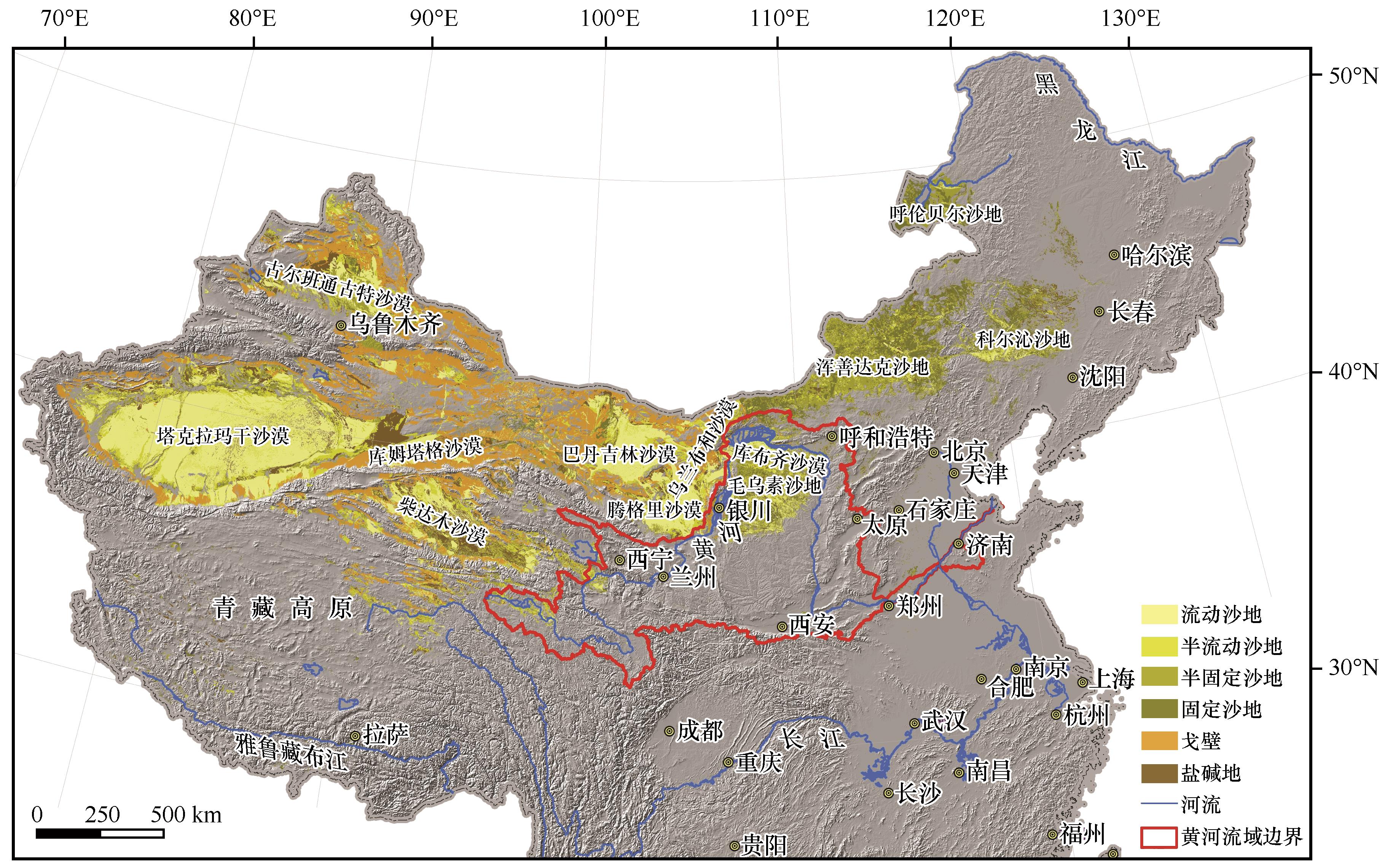
颜长珍,王建华.中国1∶10万沙漠(沙地)分布数据集[DS].兰州:国家冰川冻土沙漠科学数据中心(www.ncdc.ac.cn),2019.
|
| 13 |
董治宝,胡光印,颜长珍,等.江河源区沙漠化[M].北京:科学出版社,2013.
|
| 14 |
王涛,吴薇,王熙章.沙质荒漠化的遥感监测与评估:以中国北方沙质荒漠化区内的实践为例[J].第四纪研究,1998,18(2):108-118.
|
| 15 |
朱震达,吴正,刘恕.中国沙漠概论[M].北京:科学出版社,1980.
|
| 16 |
王涛.中国沙漠与沙漠化[M].石家庄:河北科学技术出版社,2003.
|
| 17 |
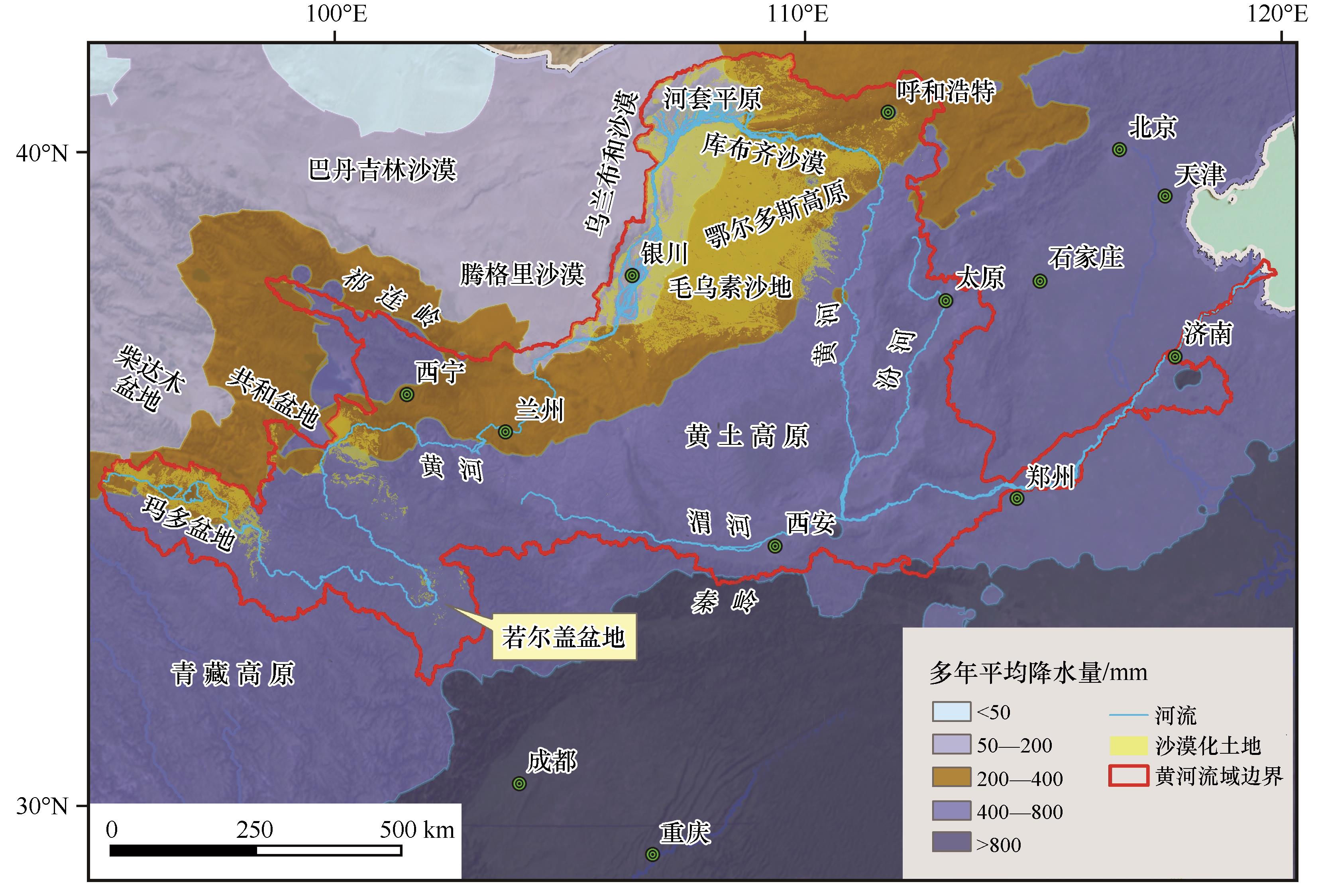
徐新良,张亚庆.中国气象背景数据集[DS].北京:中国科学院资源环境科学数据中心数据注册与出版系统(http://www.resdc.cn/DOI),2017.
|
| 18 |
竺可桢.东南季风与中国之雨量[J].地理学报,1934(1):1-27.
|
| 19 |
Nie J,Stevens T,Rittner M,et al.Loess Plateau storage of Northeastern Tibetan Plateau-derived Yellow River sediment[J].Nature Communications,2015,6:8511.
|
| 20 |
Li B,Sun D,Xu W,et al.Paleomagnetic chronology and paleoenvironmental records from drill cores from the Hetao Basin and their implications for the formation of the Hobq Desert and the Yellow River[J].Quaternary Science Reviews,2017,156:69-89.
|
| 21 |
Du J,Wang X.Optically stimulated luminescence dating of sand-dune formed within the Little Ice Age[J].Journal of Asian Earth Sciences,2014,91:154-162.
|
| 22 |
申震洲,姚文艺,肖培青,等.黄河流域砒砂岩区地貌-植被-侵蚀耦合研究进展[J].水利水运工程学报,2020(4):64-71.
|
| 23 |
董光荣,高尚玉,金炯.青海共和盆地土地沙漠化与防治途径[M].北京:科学出版社,1993.
|
| 24 |
张胜邦,董旭.青海格尔木市防治荒漠化规划研究[M].北京:中国环境科学出版社,1997.
|
| 25 |
金炯,董光荣,邵立业.阿里地区狮泉河镇风沙危害与整治规划[J].中国沙漠,1991,11(3):23-31.
|
| 26 |
董光荣,金炯,邵立业.西藏自治区”一江两河“流域土地沙漠化状况[J].中国沙漠,1991,11(1):62-64.
|
| 27 |
张伟民,董光荣,屈建军.西藏“一江两河”中部流域地区沙漠化土地基本状况[J].中国沙漠,1993,13(4):56-60.
|
| 28 |
董光荣,董玉祥,金炯,等.西藏“一江两河”中部流域地区土地沙漠化的成因与发展趋势[J].中国沙漠,1994,14(2):9-17.
|
| 29 |
李森,董光荣,董玉祥,等.西藏“一江两河”中部流域地区土地沙漠化防治目标、对策与治沙工程布局[J].中国沙漠,1994,14(2):55-63.
|
| 30 |
Li Q,Zhang C,Shen Y,et al.Quantitative assessment of the relative roles of climate change and human activities in desertification processes on the Qinghai-Tibet Plateau based on net primary productivity[J].Catena,2016,147:789-796.
|
| 31 |
Dong Z,Hu G,Qian G,et al.High-altitude aeolian research on the Tibetan Plateau[J].Reviews of Geophysics,2017,55(4):864-901.
|
| 32 |
Zhang C,Li Q,Shen Y,et al.Monitoring of aeolian desertification on the Qinghai-Tibet Plateau from the 1970s to 2015 using Landsat images[J].Science of The Total Environment,2018,619-620:1648-1659.
|
| 33 |
Hu G,Jin H,Dong Z,et al.Driving forces of aeolian desertification in the source region of the Yellow River:1975-2005[J].Environmental Earth Sciences,2013,70(7):3245-3254.
|
| 34 |
Xue X,Guo J,Han B,et al.The effect of climate warming and permafrost thaw on desertification in the Qinghai-Tibetan Plateau[J].Geomorphology,2009,108(3/4):182-190.
|
| 35 |
Hu G,Dong Z,Lu J,et al.The developmental trend and influencing factors of aeolian desertification in the Zoige Basin,eastern Qinghai-Tibet Plateau[J].Aeolian Research,2015,19:275-281.
|
| 36 |
胡梦珺,潘宁惠,左海玲,等.基于RS和GIS的玛曲高原土地沙漠化时空演变研究[J].生态学报,2017,37(3):922-931.
|
| 37 |
李森,颜长珍,宋翔,等.近30a龙羊峡水库周边地区沙漠化遥感监测[J].中国沙漠,2011,31(4):836-841.
|
| 38 |
李晓英,姚正毅,董治宝.青海省共和盆地沙漠化驱动机制[J].水土保持通报,2018,38(6):337-344.
|
| 39 |
胡梦珺,李向锋,左海玲,等.1989—2014年共和盆地贵南县土地沙漠化动态[J].中国沙漠,2018,38(1):30-38.
|
| 40 |
Li J,Yao Q,Zhou N,et al.Modern aeolian desertification on the Tibetan Plateau under climate change[J].Land Degradation & Development,2020,32(3):3862.
|
| 41 |
Li Q,Zhang C,Shen Y,et al.Developing trend of aeolian desertification in China’s Tibet Autonomous Region from 1977 to 2010[J].Environmental Earth Sciences,2016,75(10):1-12.
|
| 42 |
李庆.青藏高原土地沙漠化及驱动力研究[D].北京:北京师范大学,2016.
|
| 43 |
Wang H,Ma M,Geng L.Monitoring the recent trend of aeolian desertification using Landsat TM and Landsat 8 imagery on the north-east Qinghai-Tibet Plateau in the Qinghai Lake basin[J].Natural Hazards,2015,79(3):1753-1772.
|
| 44 |
王睿,杨国靖.库布齐沙漠生态治理的生态经济系统耦合分析[J].干旱区地理,2020,43(5):1391-1400.
|
| 45 |
刘庆福.毛乌素沙地沙漠化演变、飞播恢复评估及其对生态系统服务的影响[D].呼和浩特:内蒙古大学,2020.
|
| 46 |
孙继敏,丁仲礼,袁宝印,2000a B.P.来毛乌素地区的沙漠化问题[J].干旱区地理,1995,18(1):36-42.
|
| 47 |
黄银洲.鄂尔多斯高原近2000年沙漠化过程与成因研究[D].兰州:兰州大学,2009.
|
| 48 |
Huang Y,Wang N,He T,et al.Historical desertification of the Mu Us Desert,Northern China:a multidisciplinary study[J].Geomorphology,2009,110(3/4):108-117.
|
| 49 |
Wen P,Wang N,Wang Y,et al.Fluvial incision caused irreversible environmental degradation of an ancient city in the Mu Us Desert,China[J].Quaternary Research,2020,99:1-13.
|
| 50 |
冯坤,颜长珍,谢家丽,等.1975—2015年鄂尔多斯市沙漠化的时空演变过程[J].中国沙漠,2018,38(2):233-242.
|
| 51 |
白壮壮,崔建新,丁晓辉.1986—2015年鄂尔多斯高原沙漠化及其驱动因素研究[J].干旱区研究,2020,37(3):749-756.
|
| 52 |
王涛.中国北方沙漠与沙漠化图集[M].北京:科学出版社,2014.
|
| 53 |
胡光印,董治宝,魏振海,等.近30a来若尔盖盆地沙漠化时空演变过程及成因分析[J].地球科学进展,2009,24(8):908-916.
|
| 54 |
王涛.我国沙漠化研究的若干问题:2.沙漠化的研究内容[J].中国沙漠,2003,23(5):1-6.
|
| 55 |
吴正.浅议我国北方地区的沙漠化问题[J].地理学报,1991,46(3):266-276.
|
| 56 |
徐丽娇,胡泽勇,赵亚楠,等.1961—2010年青藏高原气候变化特征分析[J].高原气象,2019,38(5):911-919.
|
| 57 |
侯冰飞.黄河源区气候变化与径流补给的关联性分析[D].北京:北京林业大学,2020.
|
| 58 |
Zeng Z,Ziegler A D,Searchinger T,et al.A reversal in global terrestrial stilling and its implications for wind energy production[J].Nature Climate Change,2019,9(12):979-985.
|
| 59 |
Chen L,Li D,Pryor S C.Wind speed trends over China:quantifying the magnitude and assessing causality[J].International Journal of Climatology,2013,33(11):2579-2590.
|
| 60 |
李晓岚.毛乌素沙地沙漠化逆转过程及成因分析[D].西安:陕西师范大学,2017.
|
| 61 |
Mcvicar T R,Roderick M L,Donohue R J,et al.Global review and synthesis of trends in observed terrestrial near-surface wind speeds:implications for evaporation[J].Journal of Hydrology,2012,416:182-205.
|
| 62 |
Yang H,Yang D.Climatic factors influencing changing pan evaporation across China from 1961 to 2001[J].Journal of Hydrology,2012,414:184-193.
|
| 63 |
Vitousek P M,Mooney H A,Lubchenco J,et al.Human domination of earth's ecosystems[J].Science,1997,277(5325):494.
|
| 64 |
宋永永,薛东前,夏四友,等.近40a黄河流域国土空间格局变化特征与形成机理[J].地理研究,2021,40(5):1445-1463.
|
| 65 |
董立新,王文科,孔金玲,等.黄河上游玛多县生态环境变化遥感监测及成因分析[J].水土保持通报,2005,25(4):68-72.
|
| 66 |
Dong Z,Hu G,Yan C,et al.Aeolian desertification and its causes in the Zoige Plateau of China’s Qinghai-Tibetan Plateau[J].Environmental Earth Sciences,2010,59(8):1731-1740.
|
| 67 |
郭连云,丁生祥,汪青春.气候变化与人类活动对共和盆地生态环境的影响[J].干旱地区农业研究,2009,27(1):219-226.
|
 ), 董治宝1, 逯军峰2, 杨林海1, 南维鸽1, 肖锋军1


 甘公网安备 62010202000688号