| 1 |
Fryrear D W, Saleh A.Field wind erosion-vertical distribution[J].Soil Science,1993,155(4):294-300.
|
| 2 |
冯净雪,丁占良,尤莉,等.科尔沁沙地西部横向沙丘间的风况和输沙势[J].中国沙漠,2022,42(4):110-119.
|
| 3 |
李晋昌,韩柳彦,赵艳芳,等.晋北沙漠化地区起沙风风况与输沙势[J].中国沙漠,2016,36(4):911-917.
|
| 4 |
张姚姚.柴达木盆地沙漠风能环境特征及其对风沙地貌发育的影响[D].太原:太原师范学院,2023.
|
| 5 |
Hereher M E.Assessment of sand drift potential along the Nile Valley and Delta using climatic and satellite data[J].Applied Ueography,2014,55:39-47.
|
| 6 |
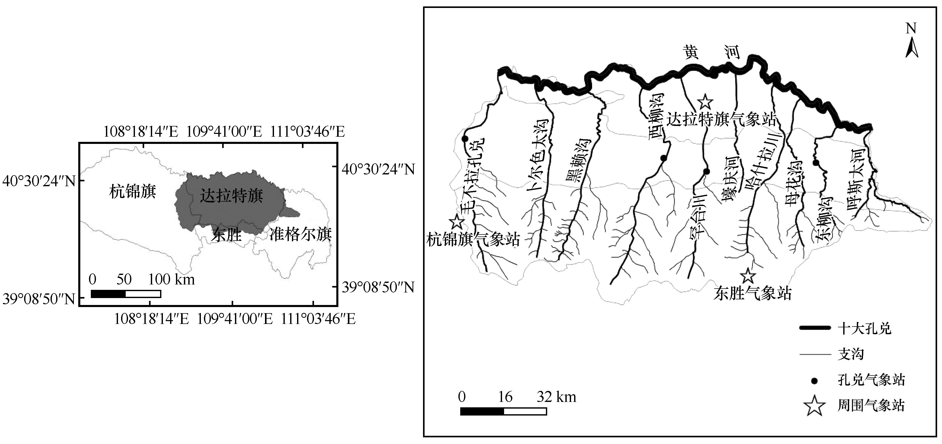
Al-Awadhi J M, Al-Helal A, Al-Enezi A.Sand drift potential in the desert of Kuwait[J].Journal of Arid Environments,2006,63(2):425-438.
|
| 7 |
Moursy F I, Uaber E I, Samak M.Sand drilt potential in El-Khanka area,Egypt[J].Water,Air,and Soil Pollution,2002,136(1):225-242.
|
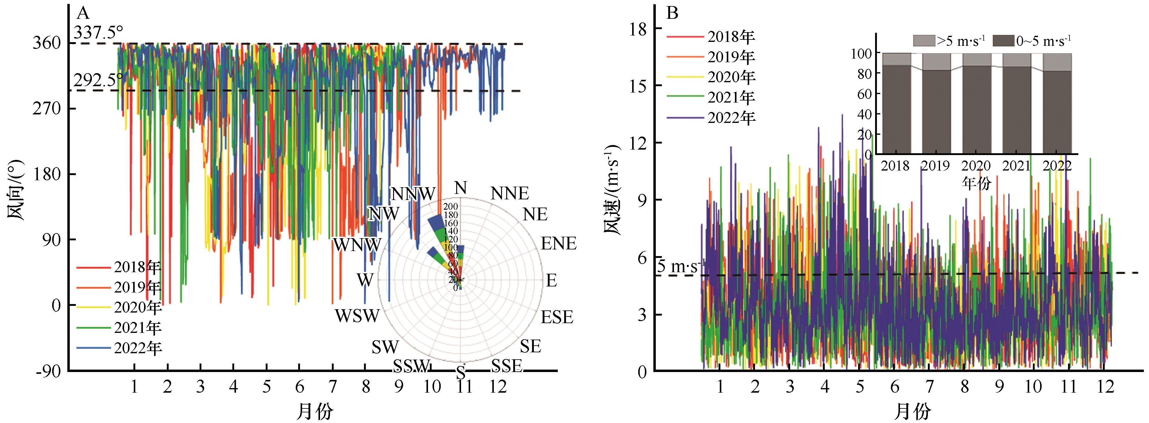
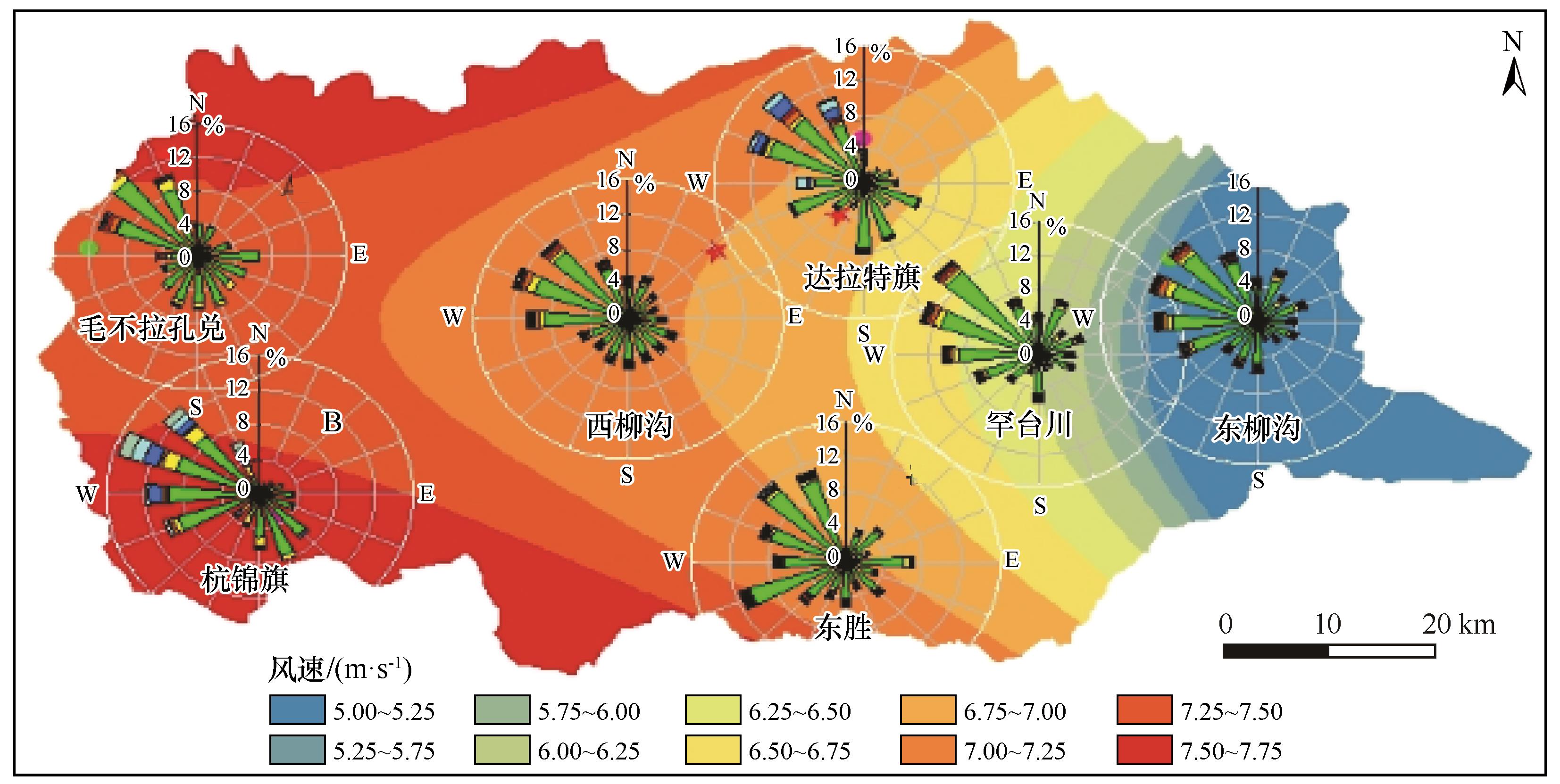
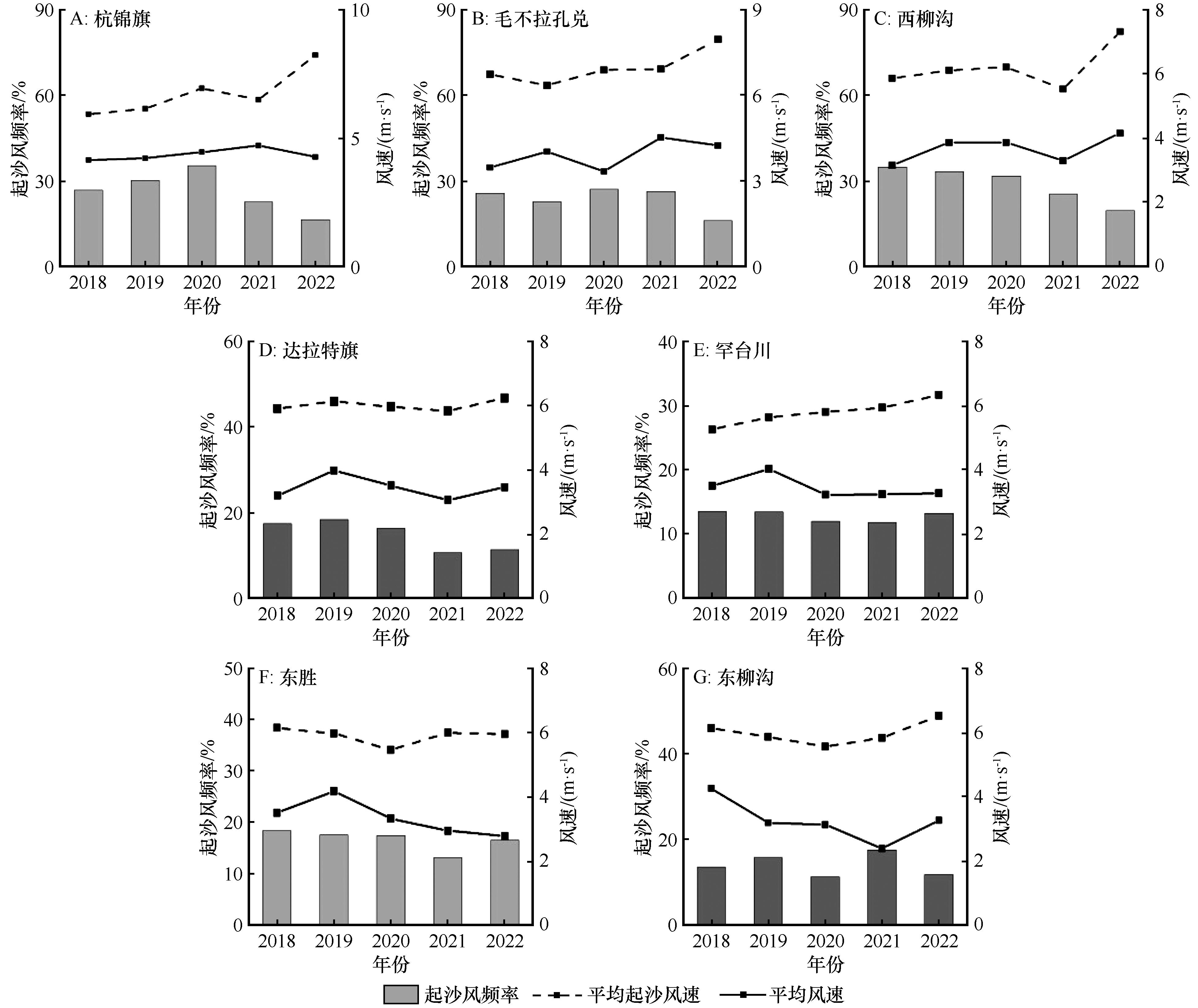
| 8 |
张昊,党晓宏,蒙仲举,等.乌珠穆沁沙地主要风沙环境特征及形成机制研究[J].干旱区研究,2023,40(10):1687-1697.
|
| 9 |
杨根生,刘阳宣,史培军.黄河沿岸风成沙入黄沙量估算[J].科学通报,1988(13):1017-1021.
|
| 10 |
杜鹤强,薛娴,王涛,等.1986-2013年黄河宁蒙河段风蚀模数与风沙入河量估算[J].农业工程学报,2015,31(10):142-151.
|
| 11 |
杜鹤强,薛娴,王涛.黄河上游宁夏-内蒙古段跃移沙粒起动风速时空分布[J].农业工程学报,2013,29(14):210-219.
|
| 12 |
王怀柏,赵淑饶,张家军,等.1950—2010年黄河径流情势变化特点[J].人民黄河,2011,33(12):16-18.
|
| 13 |
申冠卿,张原锋,侯素珍,等.黄河上游干流水库布齐调节水沙对宁蒙河道的影响[J].泥沙研究,2007(1):67-75.
|
| 14 |
Louassa S, Merzouk M, Merzouk N K.Sand drift potential in western Algerian Hautes Plaines[J].Aeolian Research,2018,34:27-34.
|
| 15 |
Mohamed H, Ali B A, Youssef S,et al.Formation of the Wahiba Sand Sea in the Sultanate of Oman:implications of change in wind energy[J].Arabian Journal of Geosciences,2020,13(22):1102-1114.
|
| 16 |
刘殿君,于森森,孟庆东,等.黄河流域鄂尔多斯十大孔兑淤地坝减沙效应[J].水土保持研究,2023,30(2):42-49.
|
| 17 |
滑永春,孙小添,白澳,等.基于遥感黄河流域内蒙古段十大孔兑生态环境质量监测评价[J].水土保持研究,2022,29(5):199-205.
|
| 18 |
Wang X, Zhou Z, Dong Z.Control of dust emissions by geomorphic conditions,wind environments and land use in northern China:an examination based on dust storm frequency from 1960 to 2003[J].Geomorphology,2006,81(3/4):292-308.
|
| 19 |
张翔.黄河上游十大孔兑地区风水复合侵蚀产沙过程研究[D].西安:西安理工大学,2018.
|
| 20 |
Yang H, Shi C.Sediment grain-size characteristics and its sources of ten wind-water coupled erosion tributaries (the Ten Kongduis) in the Upper Yellow River[J].Water,2019,11(1):115-119.
|
| 21 |
孙宝洋,李占斌,张洋,等.黄河内蒙古支流“十大孔兑”区风蚀强度时空变化特征[J].农业工程学报,2016,32(17):112-119.
|
| 22 |
张宏雪,张克存,安志山,等.敦煌-格尔木铁路沿线荒漠灌丛风动力环境与沉积物粒度特征[J].中国沙漠,2023,43(5):49-58.
|
| 23 |
古拉依赛木·艾拜都拉,张峰,吴枫,等.腾格里沙漠沙丘沉积物粒度特征及其空间差异[J].中国沙漠,2022,42(5):133-145.
|
| 24 |
马奔腾,程建军,雷加强,等.南疆塔中-38团沙漠公路沿线风沙输移规律与防沙体系研究[J].干旱区研究,2022,39(5):1663-1672.
|
| 25 |
Zhang Z C, Dong Z B, Wen Q,et al.Wind regimes and Aeolian geomorphology in the western and southwestern Tengger Desert, NW China[J].Geological Journal,2016,50(6):707-719.
|
| 26 |
胡光印,董治宝,张正偲,等.若尔盖盆地起沙风风况与输沙势特征[J].中国沙漠,2020,40(5):20-24.
|
| 27 |
邢文娟,雷加强,王海峰,等.荒漠-绿洲过渡带风况及输沙势分析:以策勒县为例[J].干旱区研究,2008,25(6):894-898.
|
| 28 |
苗恒录,王健,张瑞强,等.内蒙古阴山北麓荒漠草原风况与输沙势研究:以希拉穆仁草原为例[J].干旱区资源与环境,2022,36(4):102-110.
|
| 29 |
陈朝良,赵广举,穆兴民,等.基于RUSLE模型的湟水流域土壤侵蚀时空变化[J].水土保持学报,2021,35(4):73-79.
|
| 30 |
戴礼飞.基于GIS和RUSLE的乌拉山区小流域综合治理[D].北京:北京林业大学,2013.
|
| 31 |
王宁,杨光,韩雪莹,等.内蒙古1990—2018年土地利用变化及生态系统服务价值[J].水土保持学报,2020,34(5):244-250.
|
| 32 |
党晓宏,魏亚娟,蒙仲举,等.乌兰布和沙漠东北缘不同下垫面降尘特征研究[J].应用基础与工程科学学报,2020,28(5):1122-1133.
|
| 33 |
朱世忠.基于遥感的晋北沙化区植被覆盖变化监测[J].东北林业大学学报,2014,42(8):69-74.
|
| 34 |
Alamusa, Su Y H, Yin J W,et al.Effect of sand-fixing vegetation on the hydrological regulation function of sand dunes and its practical significance[J].Journal of Arid Land,2023,15(1):52-62.
|
 ), 高永1,2,3, 蒙仲举1,2,3, 李婉娇4, 冯霜1, 党晓宏5(

 甘公网安备 62010202000688号