img

官方微信

高级检索

中国沙漠 ›› 2021, Vol. 41 ›› Issue (1): 10-18.DOI: 10.7522/j.issn.1000-694X.2020.00092

• • 上一篇    下一篇

雅鲁藏布江曲水-泽当段风沙活动动力条件分析与风沙灾害防治建议

马鹏飞1(), 张正偲2(), 论珠群培3, 高佳佳4, 戴睿1, 次旺1, 潘凯佳2   

  1. 1.西藏自治区气候中心,西藏 拉萨 850000
    2.中国科学院西北生态环境资源研究院 沙漠与沙漠化重点实验室,甘肃 兰州 730000
    3.山南市气象局,西藏 山南 856000
    4.西藏高原大气环境科学研究所 西藏高原大气环境重点实验室,西藏 拉萨 850000
  • 收稿日期:2020-06-03 修回日期:2020-08-21 出版日期:2021-01-29 发布日期:2021-01-29
  • 通讯作者: 张正偲
  • 作者简介:张正偲(E-mail: zhangzhsi@lzb.ac.cn
    马鹏飞(1982—),男,山东栖霞人,高级工程师,主要从事气候与气候变化研究。E-mail: 85777975@qq.com
  • 基金资助:
    国家自然科学基金项目(41930640);西藏自治区科技重点研发计划项目“西藏主要地表特征科学考察及研究”;西藏自治区“十三五”重点规划项目“雅江北岸易地扶贫搬迁区沙尘监测与预报预警系统建设”

Analysis on the sand transport wind power conditions and suggestions on the sand disaster preventions in the middle reaches of Yarlung Zangbo River, China

Pengfei Ma1(), Zhengcai Zhang2(), Qunpei Lunzhu3, Jiajia Gao4, Rui Dai1, Wang Ci1, Kaijia Pan2   

  1. 1.Tibet Climate Center,Lhasa 850000,China
    2.Key Laboratory of Desert and Desertification,Northwest Institute of Eco-Environment and Resources,Chinese Academy of Sciences,Lanzhou 730000,China
    3.Shannan Meteorological Bureau,Shannan 856000,Tibet,China
    4.Key Laboratory of Tibet Atmospherical Environment,Tibet Institute of Plateau Atmospheric and Environmental Science,Lhasa 850000,China
  • Received:2020-06-03 Revised:2020-08-21 Online:2021-01-29 Published:2021-01-29
  • Contact: Zhengcai Zhang

摘要:

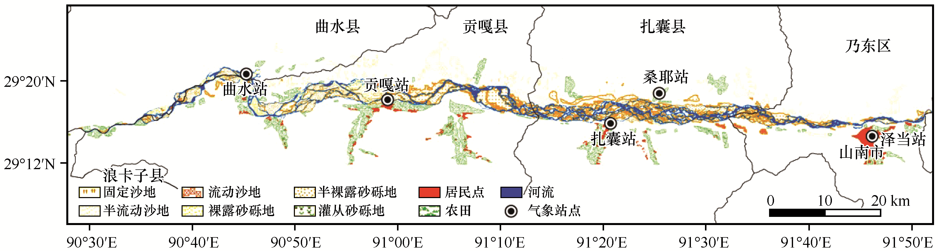
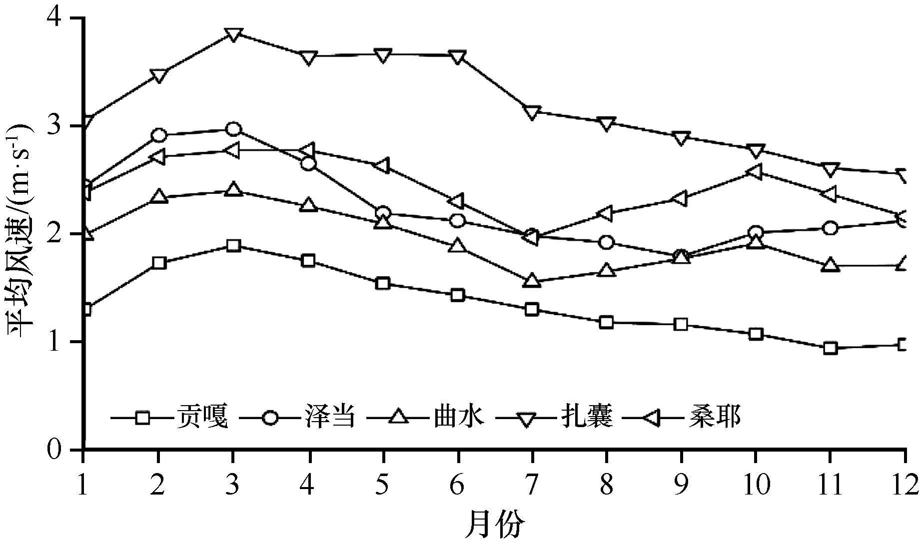
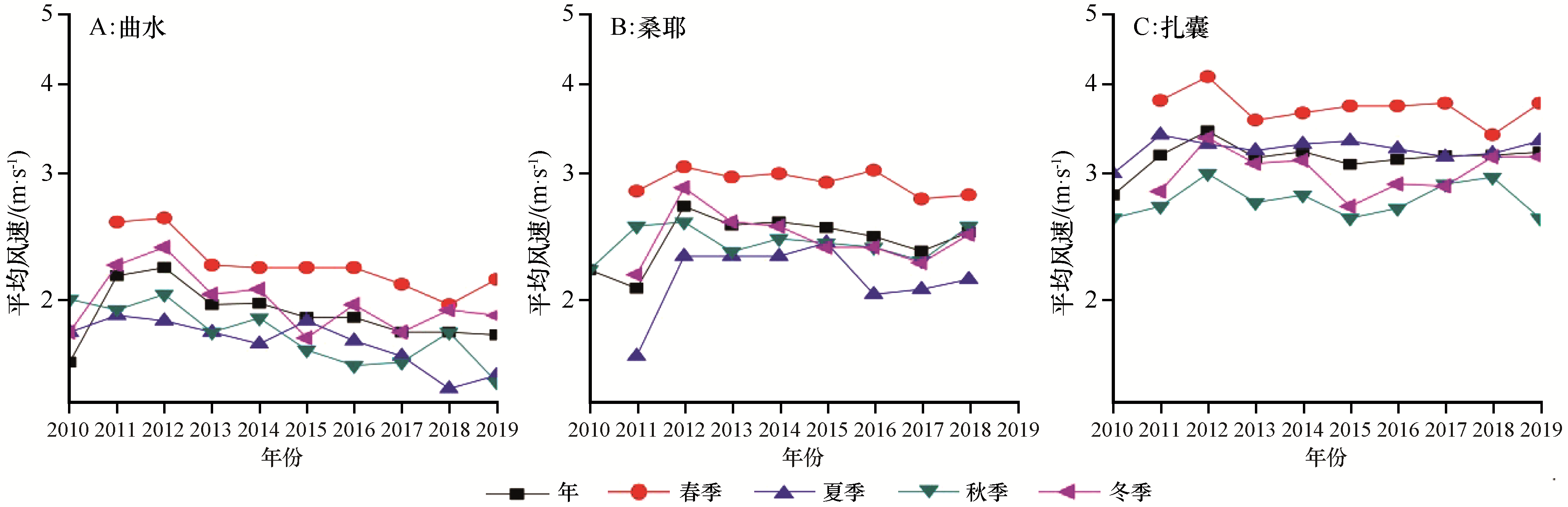
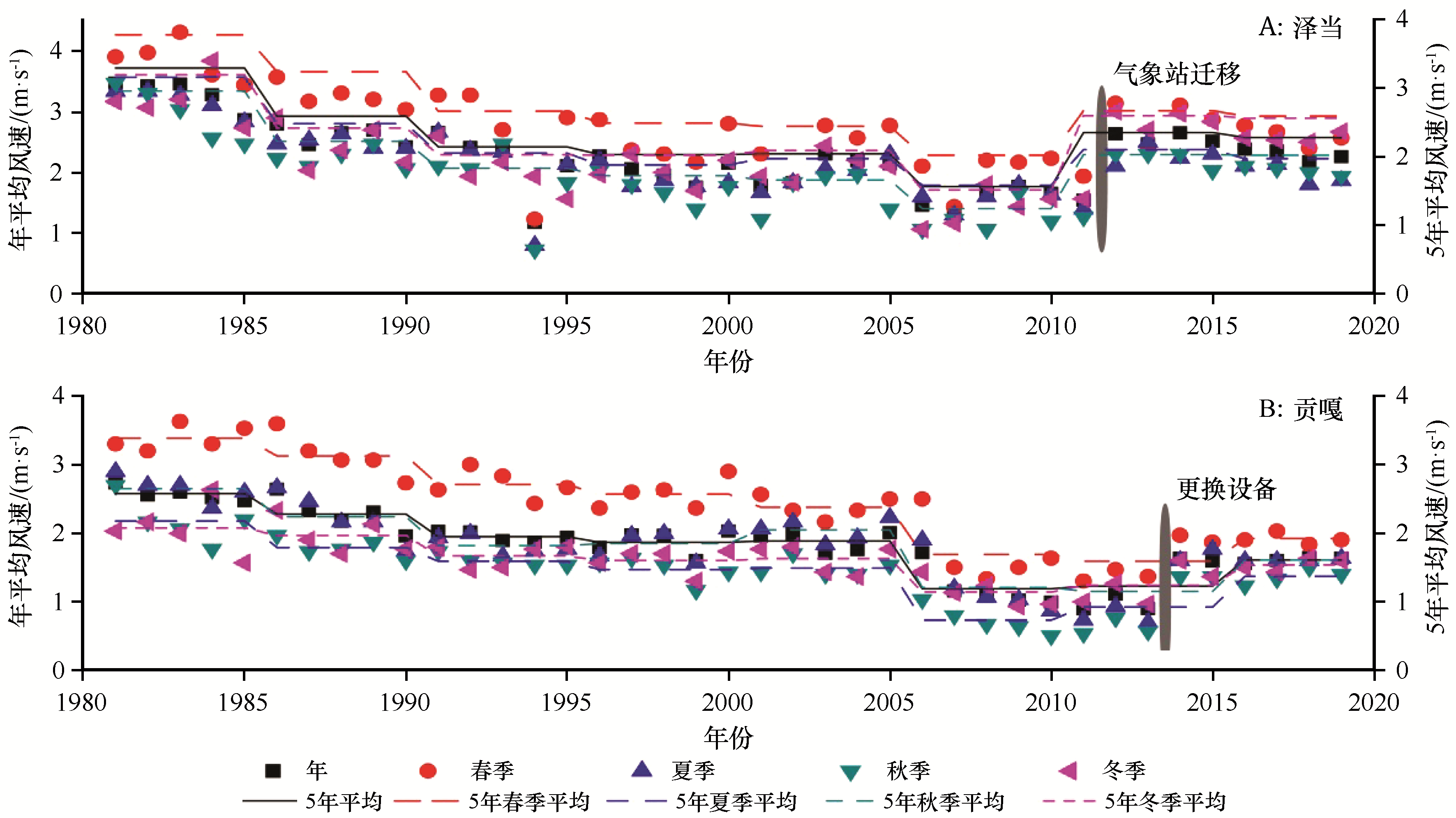
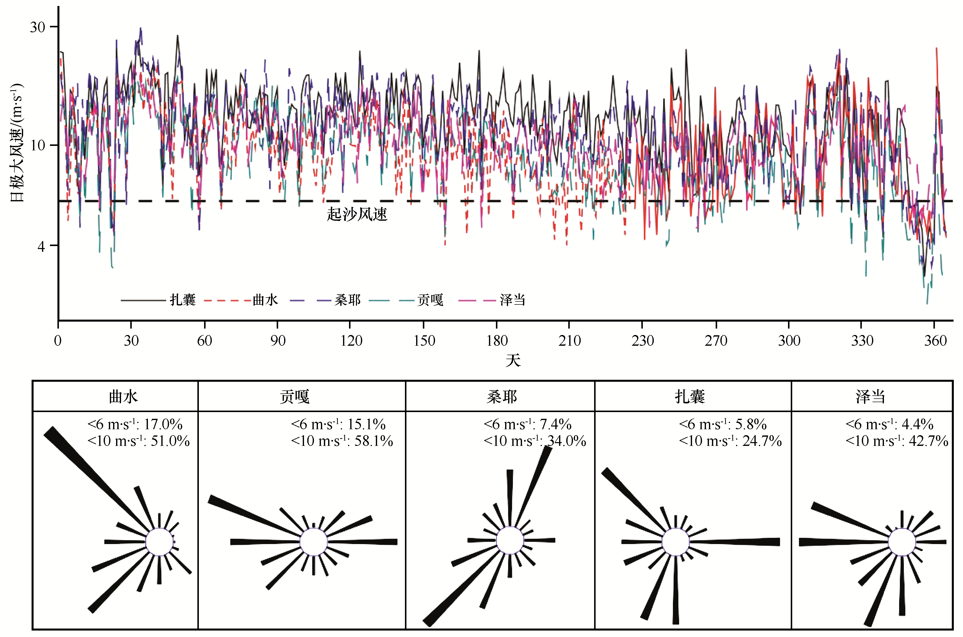
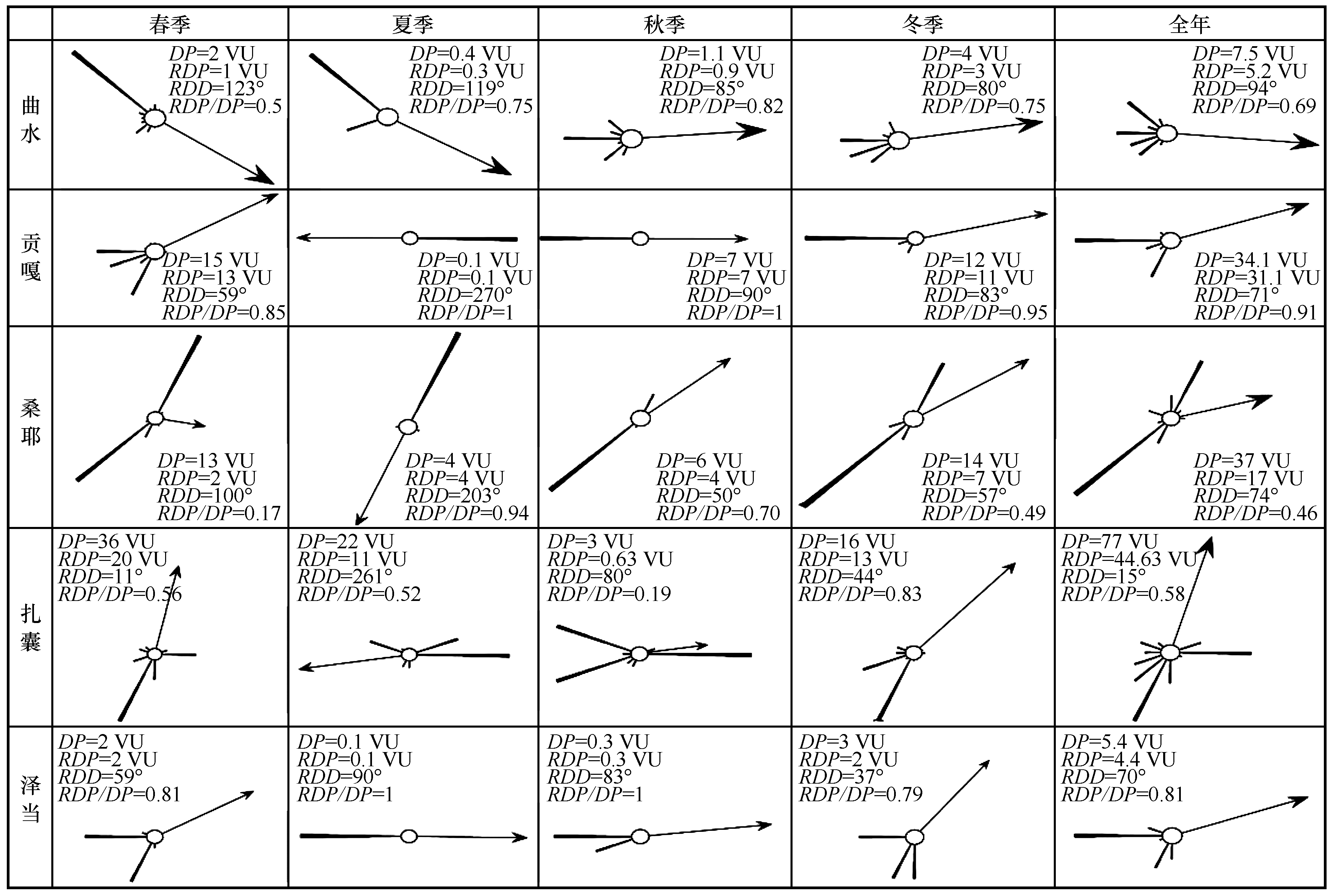
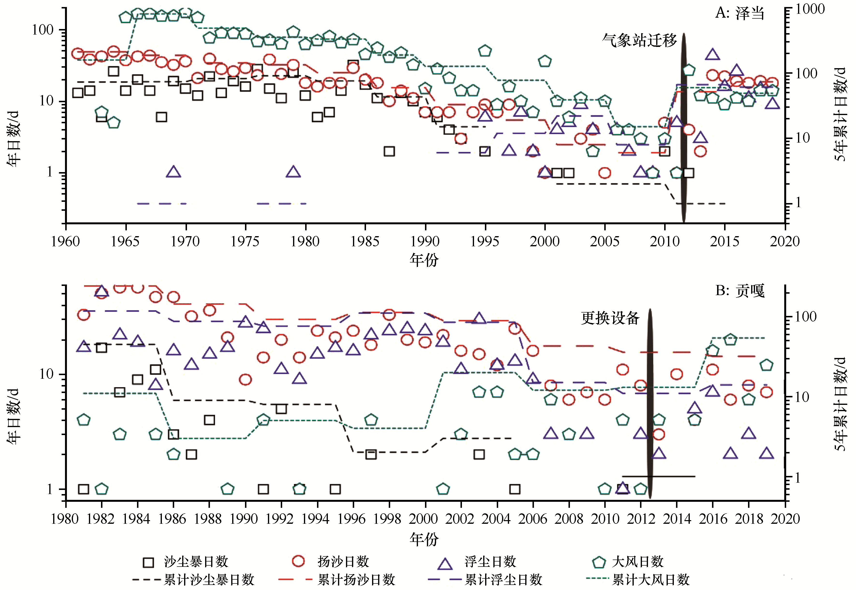
雅鲁藏布江河流宽谷区是青藏高原风沙活动最为强烈地区之一。本文选择雅鲁藏布江曲水-泽当段为研究区,分析该地区1981—2010年以来的风动力条件变化特征。结果表明:1981年以来年平均风速明显降低,月平均风速2—4月最大。受河流-山地复合系统的影响,风向复杂且具有明显的空间差异性,贡嘎以西风和东风为主,泽当包括西风、南风和东北风。日极大风速超过起沙风速的天数所占比例较大(>83%),且自西向东逐渐增加(泽当达96%)。冬春季输沙势所占比例最大,扎囊地区年输沙势最大(77 UV),其次为桑耶地区(37 UV),泽当地区最小(5.4 UV)。近年来,沙尘天气有增加的趋势。风动力条件特点和该段河流宽谷区广泛分布的风沙沉积物是形成该区风沙地貌空间格局、导致沙尘天气频发的主要原因。基于该区河流-山地复合系统下风沙环境的复杂性和野外实地调查结果,提出了科学布置防沙治沙措施的建议。

关键词: 雅鲁藏布江, 风沙活动, 风动力, 风沙灾害防治

Abstract:

The wide valley area in Yarlung Zangbo River is one of serious aeolian disaster affected regions in Tibet Plateau. For this reason, the Yarlung Zangbo River (Qushui to Zidane) was selected as study region; wind power condition change was analyzed since 1981. The results indicated that averaged annual and monthly wind speed decreased since 1981. Wind speed is largest from February to April. Dust storm mainly occurred at winter and spring. Wind directions are complex for the river channel, sand land and mountains compound system in the study region and are primary west and east in the Gonggar, and west, south and northeast in the Zidane. The frequency of daily maximum wind speed larger than threshold wind speed is more than 83% for all stations, and these values increased from west to east, arrive to about 96% in Zidane. Drift potential is largest in the Zhanang (99 VU), and then Sangye (56 VU). The above mentioned complex wind power system and the widely distributed sediment in the river are the main reasons for spatial distributions of aeolian geomorphology and frequently occurrence of dust storm. Based on the complex wind power system for the river channel, sand land and mountains compound system, we provide some suggestions for the rational sand disaster prevention.

Key words: Yarlung Zangbo River, aeolian sediment transport, wind power, sand disaster prevention

中图分类号: