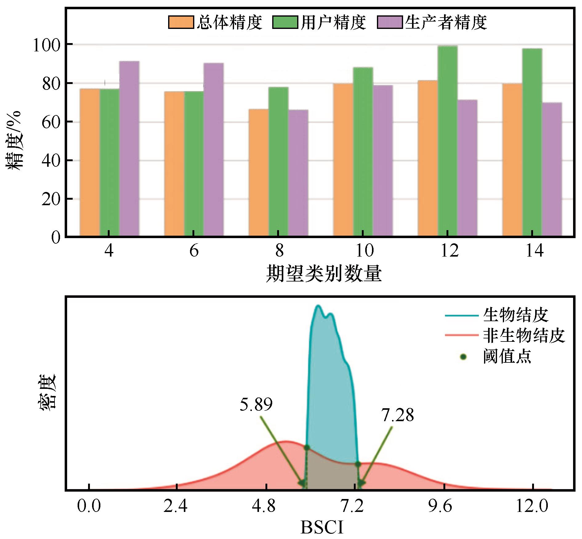
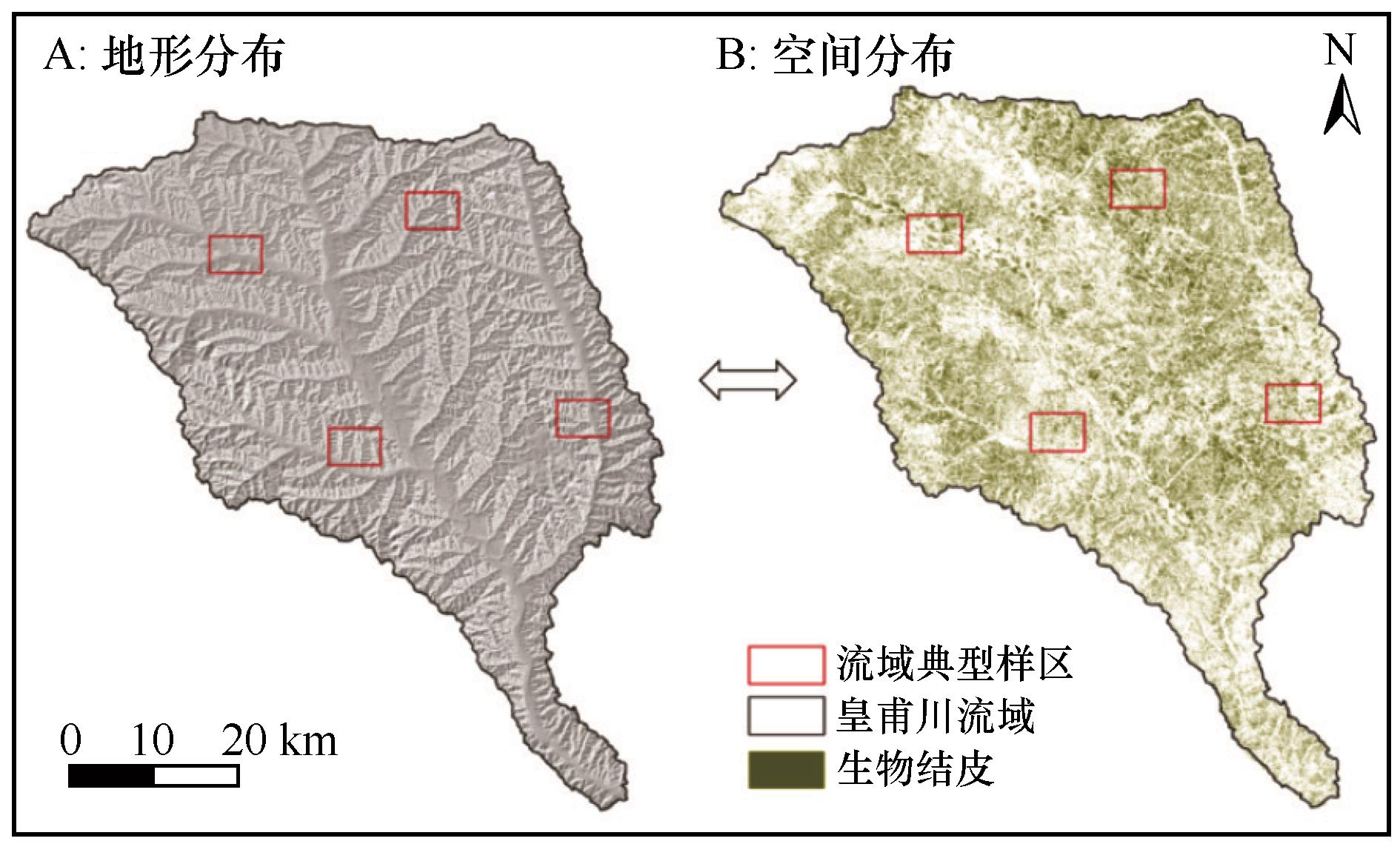
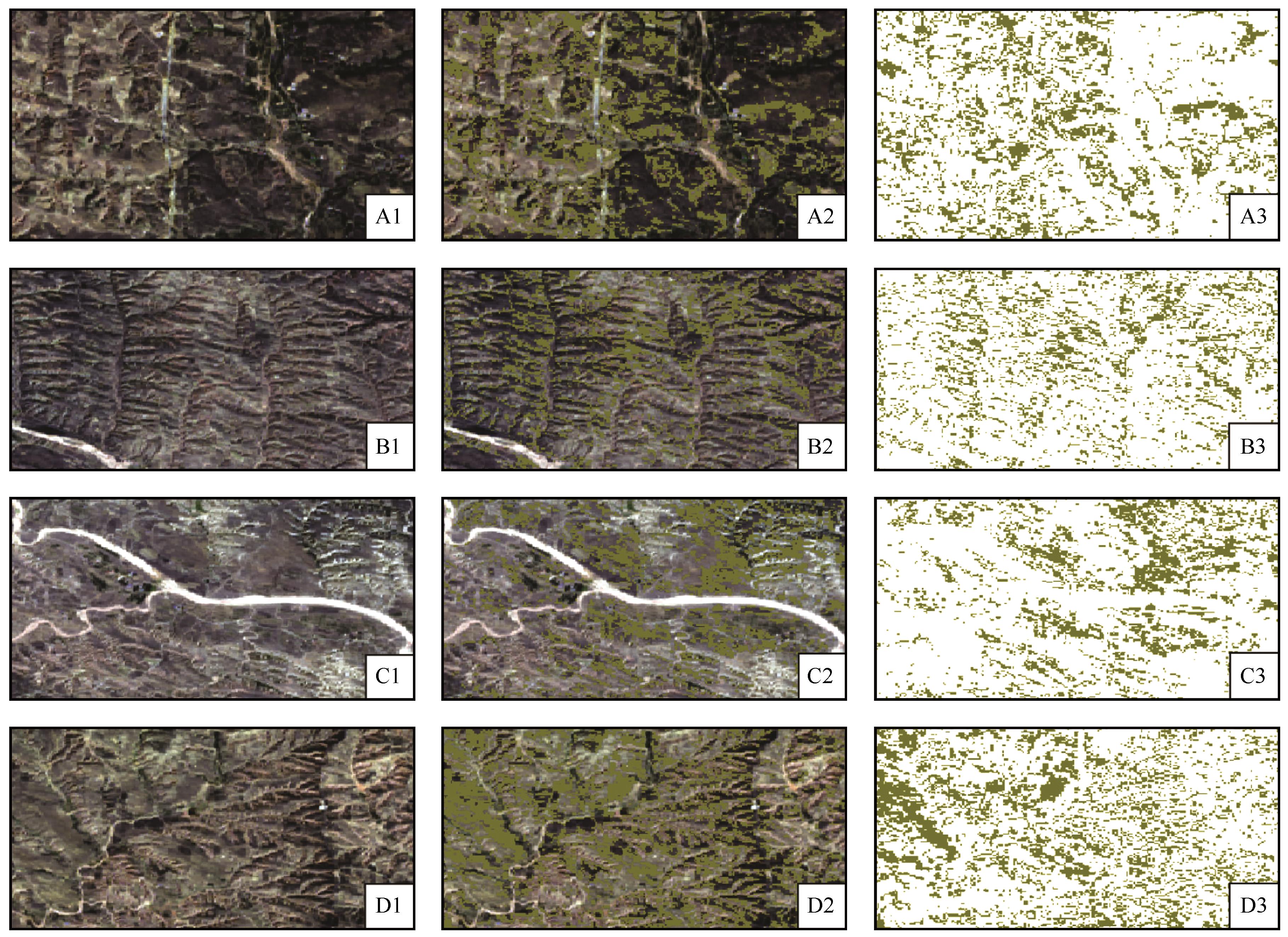
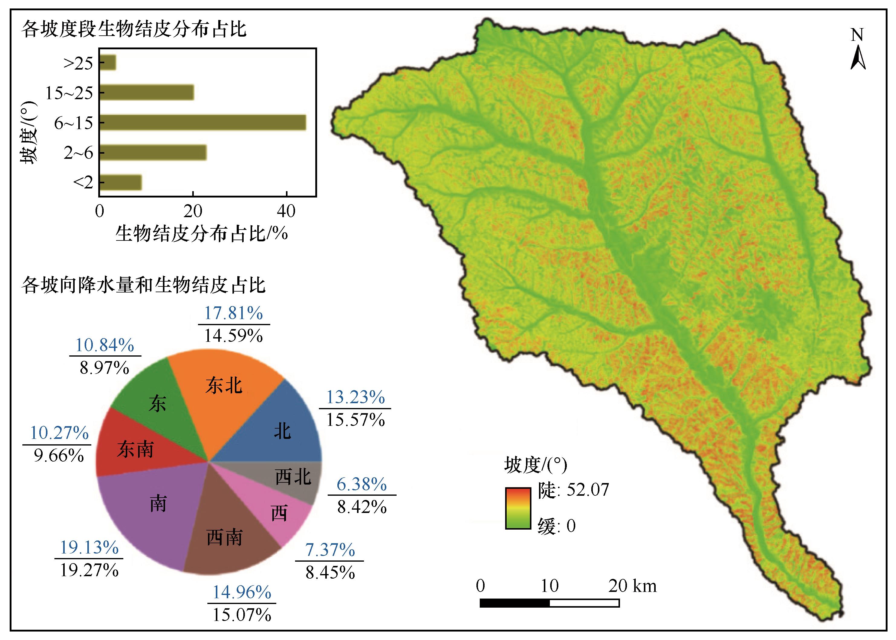
| [1] |
吴玉环,高谦,程国栋.生物土壤结皮的生态功能[J].生态学杂志,2002,21(4):41-45.
|
| [2] |
张丙昌,武志芳,李彬.黄土高原生物土壤结皮研究进展与展望[J].土壤学报,2021,58(5):1123-1131.
|
| [3] |
张雨虹,张韶阳,张树煇,等.毛乌素沙地苔藓结皮对沙化土壤性质和细菌群落的影响[J].土壤学报,2021,58(6):1585-1597.
|
| [4] |
李新荣,张志山,王新平,等.干旱区土壤植被系统恢复的生态水文学研究进展[J].中国沙漠,2009,29(5):845-852.
|
| [5] |
杨晓晖,张克斌,赵云杰.生物土壤结皮:荒漠化地区研究的热点问题[J].生态学报,2001,21(3):474-480.
|
| [6] |
李新荣,张元明,赵允格.生物土壤结皮研究:进展、前沿与展望[J].地球科学进展,2009,24(1):11-24.
|
| [7] |
肖波,赵允格,邵明安.陕北水蚀风蚀交错区两种生物结皮对土壤理化性质的影响[J].生态学报,2007,27(11):4662-4670.
|
| [8] |
高丽倩,赵允格,秦宁强,等.黄土丘陵区生物结皮对土壤可蚀性的影响[J].应用生态学报,2013,24(1):105-112.
|
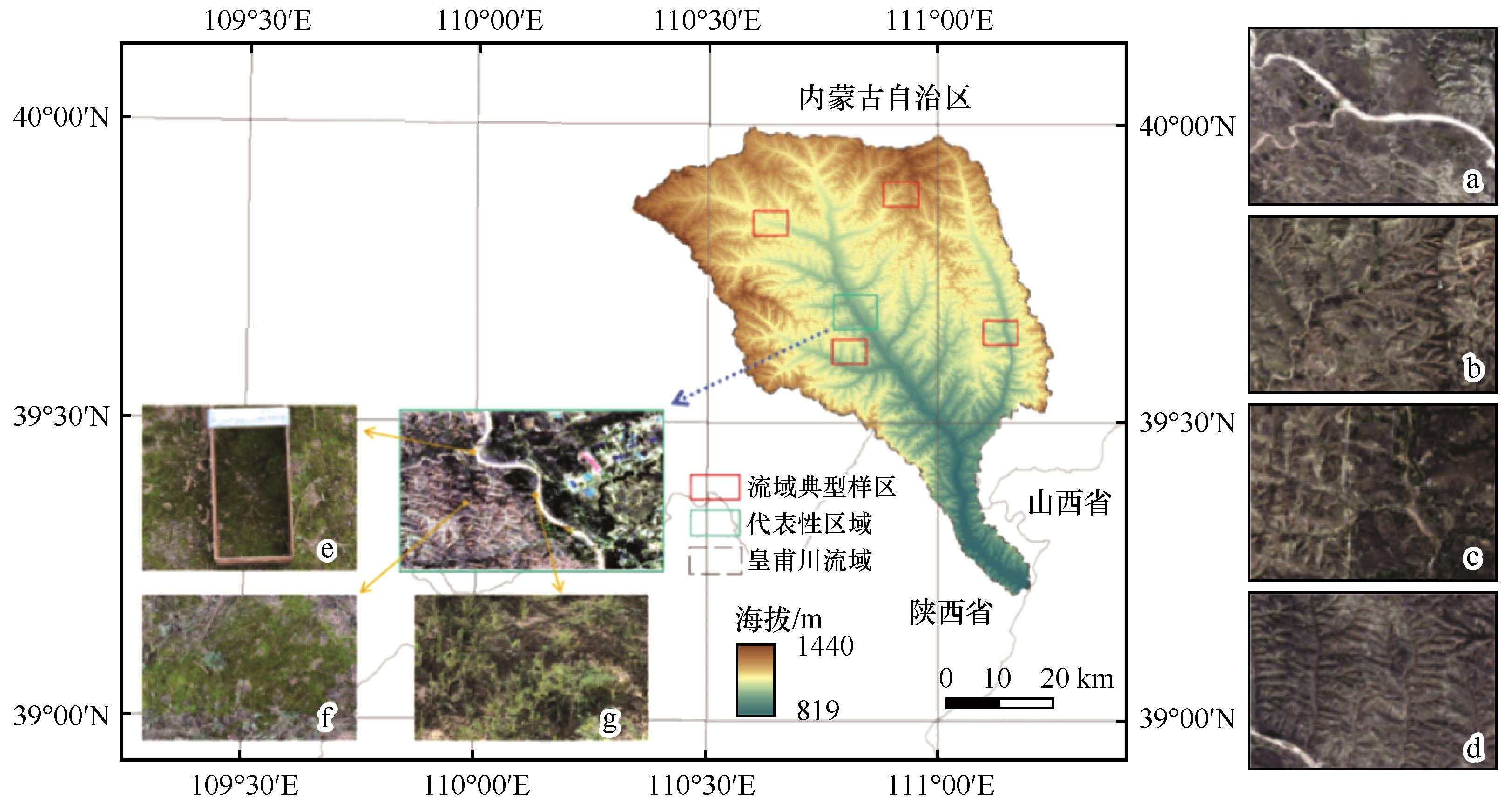
| [9] |
高丽倩,赵允格,秦宁强,等.黄土丘陵区生物结皮对土壤物理属性的影响[J].自然资源学报,2012,27(8):1316-1326.
|
| [10] |
陈瑶,张科利,罗利芳,等.黄土坡耕地弃耕后土壤入渗变化规律及影响因素[J].泥沙研究,2005(5):45-50.
|
| [11] |
田园盛,张玥,孙文义,等.黄土高原水蚀风蚀交错区不同类型生物土壤结皮光谱特征[J].光谱学与光谱分析,2018,38(7):2215-2220.
|
| [12] |
宋丽丽,白中科,樊翔,等.生物土壤结皮对照相法测量植被覆盖度结果的影响[J].生态学报,2018,38(4):1272-1283.
|
| [13] |
Baxter C, Mallen-Cooper M, Lyons M B,et al.Measuring reflectance of tiny organisms:the promise of species level biocrust remote sensing[J].Methods in Ecology and Evolution,2021,12(11):2174-2183.
|
| [14] |
张元明,陈晋,王雪芹,等.古尔班通古特沙漠生物结皮的分布特征[J].地理学报,2005,60(1):53-60.
|
| [15] |
张元明,潘惠霞,潘伯荣.古尔班通古特沙漠不同地貌部位生物结皮的选择性分布[J].水土保持学报,2004,18(4):61-64.
|
| [16] |
杨伟,陈晋,张元明,等.古尔班通古特沙漠1970-2000年代生物结皮覆盖变化研究[J].自然资源学报,2006,21(6):934-941.
|
| [17] |
冯秀绒,卜崇峰,郝红科,等.基于光谱分析的生物结皮提取研究:以毛乌素沙地为例[J].自然资源学报,2015,30(6):1024-1034.
|
| [18] |
杨丽娜,赵允格,明姣,等.黄土高原不同侵蚀类型区生物结皮中蓝藻的多样性[J].生态学报,2013,33(14):4416-4424.
|
| [19] |
赵河聚,岳艳鹏,贾晓红,等.模拟增温对高寒沙区生物土壤结皮-土壤系统呼吸的影响[J].植物生态学报,2020,44(9):916-925.
|
| [20] |
Karnieli A.Development and implementation of spectral crust index over dune sands[J].International Journal of Remote Sensing,1997,18(6):1207-1220.
|
| [21] |
Sun H, Ma X, Liu Y,et al.A New multiangle method for estimating fractional biocrust coverage from sentinel-2 data in arid areas[J].Ieee Transactions on Geoscience and Remote Sensing,2024,62:1-15.
|
| [22] |
Chen J, Yuan Z M, Wang L,et al.A new index for mapping lichen-dominated biological soil crusts in desert areas[J].Remote Sensing of Environment,2005,96(2):165-175.
|
| [23] |
李双双,延军平,万佳.近10年陕甘宁黄土高原区植被覆盖时空变化特征[J].地理学报,2012,67(7):960-970.
|
| [24] |
于红博,杨劼,陈杰.皇甫川流域地表特征参数遥感反演研究[J].人民黄河,2008,30(4):5-6.
|
| [25] |
喻锋,李晓兵,王宏.生态安全条件下土地利用格局优化:以皇甫川流域为例[J].生态学报,2014,34(12):3198-3210.
|
| [26] |
田庆久,闵祥军.植被指数研究进展[J].地球科学进展,1998,13(4):327-333.
|
| [27] |
王正兴,刘闯, Alfredo H.植被指数研究进展:从AVHRR-NDVI到MODIS-EVI[J].生态学报,2003,23(5):979-987.
|
| [28] |
王敏钰,罗毅,张正阳,等.植被物候参数遥感提取与验证方法研究进展[J].遥感学报,2022,26(3):431-455.
|
| [29] |
Guo J, Wang X, Liu B,et al.Remote-sensing extraction of small water bodies on the Loess Plateau[J].Water-Sui,2023,15(5):866.
|
| [30] |
Rodriguez-Caballero E, Belnap J, Büdel B,et al.Dryland photoautotrophic soil surface communities endangered byglobal change[J].Nature Geoscience,2018,11(3):185-189.
|
| [31] |
范德芹,赵学胜,朱文泉,等.植物物候遥感监测精度影响因素研究综述[J].地理科学进展,2016,35(3):304-319.
|
| [32] |
李素,李文正,周建军,等.遥感影像混合像元分解中的端元选择方法综述[J].地理与地理信息科学,2007,23(5):35-38.
|
| [33] |
陈珂,彭志平,柯文德.遥感图像异物同谱干扰消除技术研究与仿真[J].计算机仿真,2013,30(1):423-426.
|
| [34] |
韩炳宏,牛得草,贺磊,等.生物土壤结皮发育及其影响因素研究进展[J].草业科学,2017,34(9):1793-1801.
|
| [35] |
房世波,冯凌,刘华杰,等.生物土壤结皮对全球气候变化的响应[J].生态学报,2008,28(7):3312-3321.
|
| [36] |
van Herk C M, Aptroot A, van Dobben H F.Long-term monitoring in the Netherlands suggests that lichens respond to global warming[J].The Lichenologist,2002,34(2):141-154.
|
| [37] |
焦雯珺,朱清科,张宇清,等.陕北黄土区退耕还林地生物结皮分布及其影响因子研究[J].北京林业大学学报,2007,29(1):102-107.
|
| [38] |
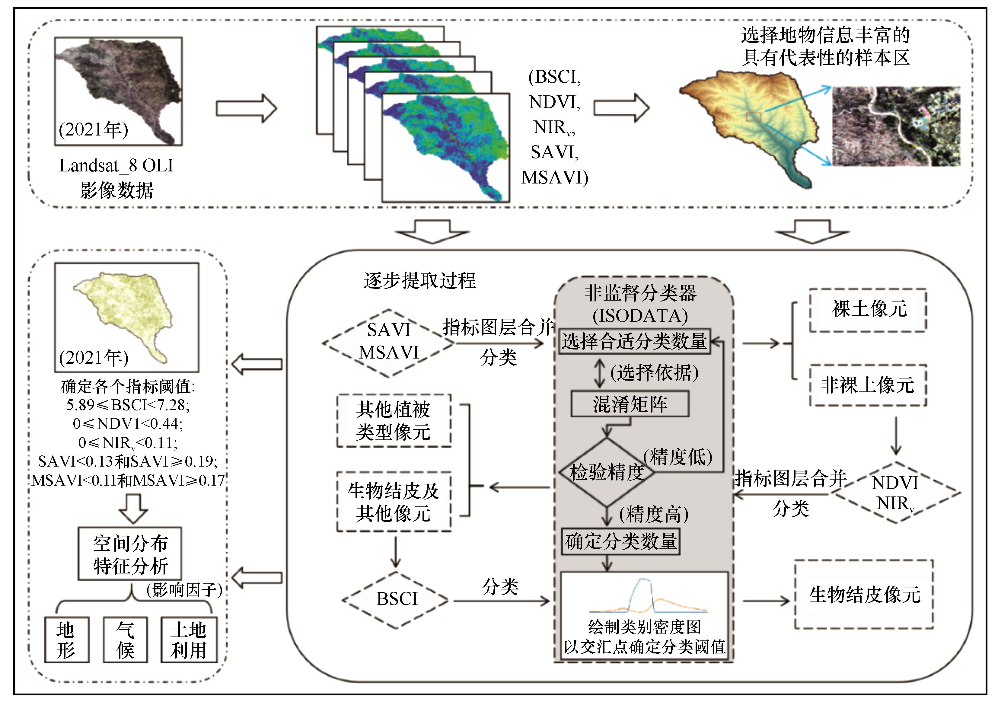
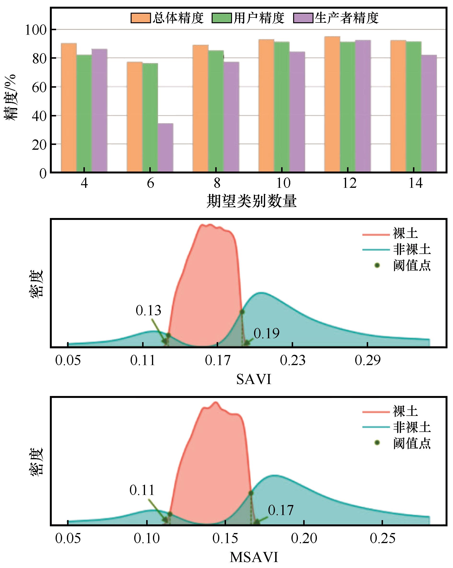
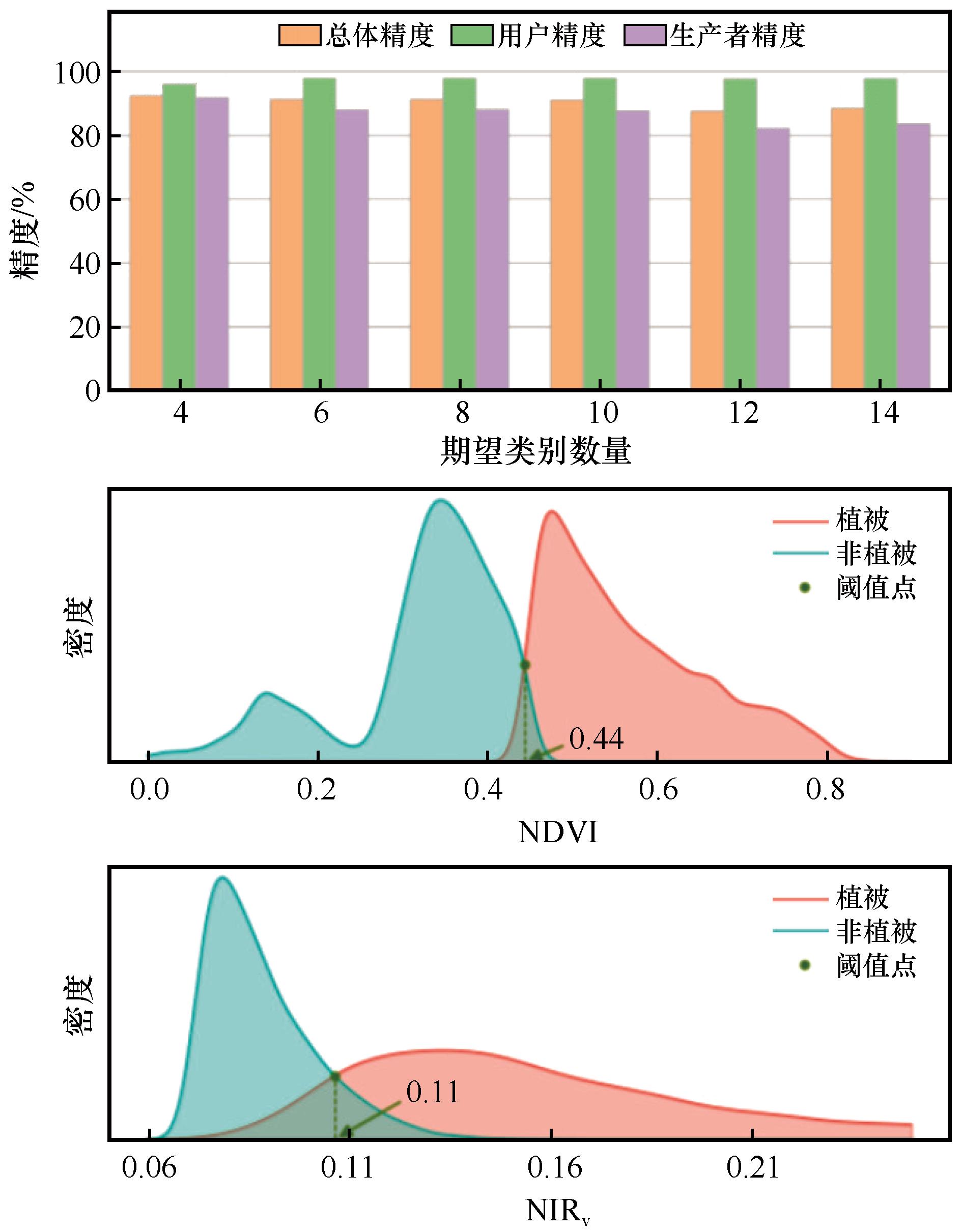
赵允格,吉静怡,张万涛,等.黄土高原生物土壤结皮分布时空分异特征[J].应用生态学报,2024,35(3):739-748.
|
 ), 王晨沣2, 刘梦云1, 王小平1,3(
 甘公网安备 62010202000688号