中国沙漠 ›› 2026, Vol. 46 ›› Issue (5): 206-220.DOI: 10.7522/j.issn.1000-694X.2026.00115
• • 上一篇
任孝宗1,2( ), 崔徐甲1,2, 秦彦智1, 陈天晶1, 崔雯茜1
收稿日期:2026-05-25
修回日期:2026-06-28
出版日期:2026-09-20
发布日期:2026-11-02
作者简介:任孝宗(1983—),男,甘肃白银人,博士,副教授,主要研究方向为水化学、水文地球化学。E-mail: renxzmail@126.com
基金资助:
Xiaozong Ren1,2(), Xujia Cui1,2, Yanzhi Qin1, Tianjing Chen1, Wenxi Cui1
Received:2026-05-25
Revised:2026-06-28
Online:2026-09-20
Published:2026-11-02
摘要:
沙漠/沙地地表沉积物易溶盐不仅深刻影响着区域岩石风化和全球盐分循环,也是土壤盐碱化的重要诱因,其空间分布特征被认为主要受控于气候因素,然而在人类活动显著的中国东部沙地,其主控因素仍不清楚。本文测定了浑善达克沙地78个地表沉积物易溶盐的水化学综合指标和10种主要离子,利用冷热点分析、标准差椭圆分析和双变量图对各离子的空间分布特征及其影响因素进行了分析。结果表明:浑善达克沙地78个地表沉积物TDS(溶解性固体总量)和pH的均值仅为15.61 mg·L-1和5.88,属阿列金水化学分类法重碳酸盐和碳酸盐类、钙质组。沙地东、西部地表沉积物易溶盐空间分异明显,西部以HCO
中图分类号:
任孝宗, 崔徐甲, 秦彦智, 陈天晶, 崔雯茜. 浑善达克沙地地表沉积物易溶盐的空间分布特征及其影响因素[J]. 中国沙漠, 2026, 46(5): 206-220.
Xiaozong Ren, Xujia Cui, Yanzhi Qin, Tianjing Chen, Wenxi Cui. Spatial distribution of soluble salts in surface sediments of Hunshandake Sandy Land and its influencing factors[J]. Journal of Desert Research, 2026, 46(5): 206-220.
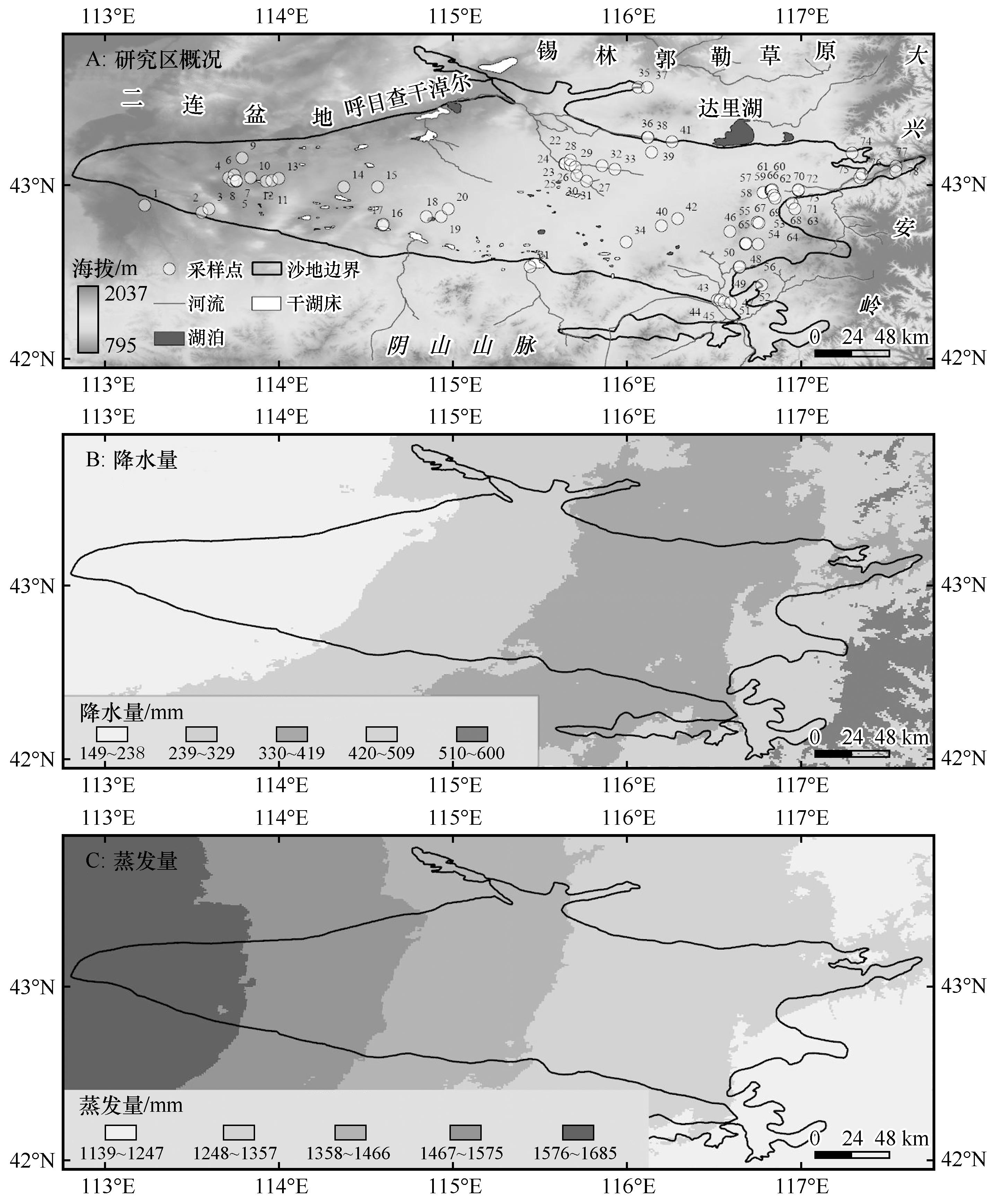
图1 研究区概况注:基于内蒙古自治区自然资源厅标准地图服务网站审图号蒙S(2023)037号标准地图制作,底图边界无修改。降雨量、蒸发量数据来源于资源环境科学数据平台2011—2024年中国气象要素各年度平均状况数据集(https://www.resdc.cn/)
Fig.1 Sketch map of the study area
| 样品类型 | 统计值 | TDS | pH | HCO | Ca2+ | Na+ | Mg2+ | K+ | F- | Cl - | SO | NH | NO | HCO +NO | 包含样品编号 |
|---|---|---|---|---|---|---|---|---|---|---|---|---|---|---|---|
| 阿列金Ⅰ型(n=49) | 最小值 | 4.00 | 4.54 | 6.14 | 1.64 | 0.23 | 0.26 | 0.72 | 0.04 | 0.11 | 0.02 | 0.00 | 0.01 | 58.01 | 1~18、20~33、36~45、48、56、58、66、70、72、73 |
| 最大值 | 50.80 | 6.54 | 114.29 | 19.62 | 6.66 | 6.28 | 12.05 | 0.92 | 7.61 | 2.41 | 0.42 | 7.63 | 89.14 | ||
| 均值 | 16.66 | 5.69 | 33.66 | 7.05 | 1.27 | 1.51 | 2.29 | 0.22 | 0.55 | 0.52 | 0.04 | 1.77 | 75.34 | ||
| 标准差 | 11.04 | 0.60 | 30.25 | 4.85 | 1.42 | 1.45 | 1.99 | 0.22 | 1.07 | 0.60 | 0.07 | 1.75 | 7.09 | ||
| 变异系数 | 0.66 | 0.11 | 0.90 | 0.69 | 1.12 | 0.96 | 0.87 | 0.99 | 1.93 | 1.16 | 1.91 | 0.99 | 0.09 | ||
| 阿列金Ⅱ型(n=3) | 最小值 | 6.00 | 4.51 | 1.56 | 2.22 | 0.21 | 0.41 | 0.43 | 0.00 | 0.15 | 0.16 | 0.00 | 0.36 | 57.35 | 57、60、67 |
| 最大值 | 22.70 | 6.78 | 13.12 | 7.93 | 0.94 | 1.55 | 2.23 | 0.25 | 0.65 | 1.67 | 0.15 | 15.90 | 79.84 | ||
| 均值 | 13.52 | 6.18 | 5.43 | 4.14 | 0.45 | 0.93 | 1.07 | 0.09 | 0.33 | 0.70 | 0.02 | 4.21 | 69.38 | ||
| 标准差 | 4.91 | 0.52 | 2.13 | 1.32 | 0.16 | 0.27 | 0.50 | 0.06 | 0.12 | 0.39 | 0.03 | 4.40 | 5.63 | ||
| 变异系数 | 0.36 | 0.08 | 0.39 | 0.32 | 0.36 | 0.29 | 0.46 | 0.67 | 0.38 | 0.55 | 1.41 | 1.04 | 0.08 | ||
| 阿列金Ⅲ型(n=26) | 最小值 | 9.60 | 6.06 | 5.60 | 2.64 | 0.33 | 0.67 | 0.57 | 0.06 | 0.33 | 0.82 | 0.01 | 1.73 | 49.68 | 19、34、35、46、47、49、50、51、52、53、54、55、59、61、62、63、64、65、68、69、71、74、75、76、77、78 |
| 最大值 | 29.60 | 6.32 | 8.71 | 4.50 | 1.22 | 1.36 | 2.57 | 0.20 | 1.48 | 6.74 | 0.02 | 3.17 | 70.99 | ||
| 均值 | 16.67 | 6.19 | 7.05 | 3.59 | 0.64 | 0.93 | 1.29 | 0.12 | 0.73 | 2.85 | 0.02 | 2.35 | 62.95 | ||
| 标准差 | 11.22 | 0.13 | 1.57 | 0.93 | 0.50 | 0.37 | 1.11 | 0.07 | 0.66 | 3.37 | 0.01 | 0.74 | 11.58 | ||
| 变异系数 | 0.67 | 0.02 | 0.22 | 0.26 | 0.77 | 0.40 | 0.86 | 0.61 | 0.90 | 1.18 | 0.34 | 0.32 | 0.18 | ||
| 全部水型(n=78) | 最小值 | 4.00 | 4.51 | 1.56 | 1.64 | 0.21 | 0.26 | 0.43 | 0.00 | 0.11 | 0.02 | 0.00 | 0.01 | 49.68 | 1~78 |
| 最大值 | 50.80 | 6.78 | 114.29 | 19.62 | 6.66 | 6.28 | 12.05 | 0.92 | 7.61 | 6.74 | 0.42 | 15.90 | 89.14 | ||
| 均值 | 15.61 | 5.88 | 23.23 | 5.95 | 0.97 | 1.29 | 1.84 | 0.17 | 0.48 | 0.67 | 0.03 | 2.61 | 72.88 | ||
| 标准差 | 9.45 | 0.61 | 27.54 | 4.16 | 1.19 | 1.19 | 1.71 | 0.19 | 0.86 | 0.88 | 0.06 | 3.09 | 7.55 | ||
| 变异系数 | 0.61 | 0.10 | 1.19 | 0.70 | 1.23 | 0.92 | 0.93 | 1.09 | 1.77 | 1.31 | 1.90 | 1.18 | 0.10 |
表1 易溶盐浸提液水化学综合指标和各离子含量
Table 1 The synthetic parameters and ion contents in extraction solution from soluble salt
| 样品类型 | 统计值 | TDS | pH | HCO | Ca2+ | Na+ | Mg2+ | K+ | F- | Cl - | SO | NH | NO | HCO +NO | 包含样品编号 |
|---|---|---|---|---|---|---|---|---|---|---|---|---|---|---|---|
| 阿列金Ⅰ型(n=49) | 最小值 | 4.00 | 4.54 | 6.14 | 1.64 | 0.23 | 0.26 | 0.72 | 0.04 | 0.11 | 0.02 | 0.00 | 0.01 | 58.01 | 1~18、20~33、36~45、48、56、58、66、70、72、73 |
| 最大值 | 50.80 | 6.54 | 114.29 | 19.62 | 6.66 | 6.28 | 12.05 | 0.92 | 7.61 | 2.41 | 0.42 | 7.63 | 89.14 | ||
| 均值 | 16.66 | 5.69 | 33.66 | 7.05 | 1.27 | 1.51 | 2.29 | 0.22 | 0.55 | 0.52 | 0.04 | 1.77 | 75.34 | ||
| 标准差 | 11.04 | 0.60 | 30.25 | 4.85 | 1.42 | 1.45 | 1.99 | 0.22 | 1.07 | 0.60 | 0.07 | 1.75 | 7.09 | ||
| 变异系数 | 0.66 | 0.11 | 0.90 | 0.69 | 1.12 | 0.96 | 0.87 | 0.99 | 1.93 | 1.16 | 1.91 | 0.99 | 0.09 | ||
| 阿列金Ⅱ型(n=3) | 最小值 | 6.00 | 4.51 | 1.56 | 2.22 | 0.21 | 0.41 | 0.43 | 0.00 | 0.15 | 0.16 | 0.00 | 0.36 | 57.35 | 57、60、67 |
| 最大值 | 22.70 | 6.78 | 13.12 | 7.93 | 0.94 | 1.55 | 2.23 | 0.25 | 0.65 | 1.67 | 0.15 | 15.90 | 79.84 | ||
| 均值 | 13.52 | 6.18 | 5.43 | 4.14 | 0.45 | 0.93 | 1.07 | 0.09 | 0.33 | 0.70 | 0.02 | 4.21 | 69.38 | ||
| 标准差 | 4.91 | 0.52 | 2.13 | 1.32 | 0.16 | 0.27 | 0.50 | 0.06 | 0.12 | 0.39 | 0.03 | 4.40 | 5.63 | ||
| 变异系数 | 0.36 | 0.08 | 0.39 | 0.32 | 0.36 | 0.29 | 0.46 | 0.67 | 0.38 | 0.55 | 1.41 | 1.04 | 0.08 | ||
| 阿列金Ⅲ型(n=26) | 最小值 | 9.60 | 6.06 | 5.60 | 2.64 | 0.33 | 0.67 | 0.57 | 0.06 | 0.33 | 0.82 | 0.01 | 1.73 | 49.68 | 19、34、35、46、47、49、50、51、52、53、54、55、59、61、62、63、64、65、68、69、71、74、75、76、77、78 |
| 最大值 | 29.60 | 6.32 | 8.71 | 4.50 | 1.22 | 1.36 | 2.57 | 0.20 | 1.48 | 6.74 | 0.02 | 3.17 | 70.99 | ||
| 均值 | 16.67 | 6.19 | 7.05 | 3.59 | 0.64 | 0.93 | 1.29 | 0.12 | 0.73 | 2.85 | 0.02 | 2.35 | 62.95 | ||
| 标准差 | 11.22 | 0.13 | 1.57 | 0.93 | 0.50 | 0.37 | 1.11 | 0.07 | 0.66 | 3.37 | 0.01 | 0.74 | 11.58 | ||
| 变异系数 | 0.67 | 0.02 | 0.22 | 0.26 | 0.77 | 0.40 | 0.86 | 0.61 | 0.90 | 1.18 | 0.34 | 0.32 | 0.18 | ||
| 全部水型(n=78) | 最小值 | 4.00 | 4.51 | 1.56 | 1.64 | 0.21 | 0.26 | 0.43 | 0.00 | 0.11 | 0.02 | 0.00 | 0.01 | 49.68 | 1~78 |
| 最大值 | 50.80 | 6.78 | 114.29 | 19.62 | 6.66 | 6.28 | 12.05 | 0.92 | 7.61 | 6.74 | 0.42 | 15.90 | 89.14 | ||
| 均值 | 15.61 | 5.88 | 23.23 | 5.95 | 0.97 | 1.29 | 1.84 | 0.17 | 0.48 | 0.67 | 0.03 | 2.61 | 72.88 | ||
| 标准差 | 9.45 | 0.61 | 27.54 | 4.16 | 1.19 | 1.19 | 1.71 | 0.19 | 0.86 | 0.88 | 0.06 | 3.09 | 7.55 | ||
| 变异系数 | 0.61 | 0.10 | 1.19 | 0.70 | 1.23 | 0.92 | 0.93 | 1.09 | 1.77 | 1.31 | 1.90 | 1.18 | 0.10 |
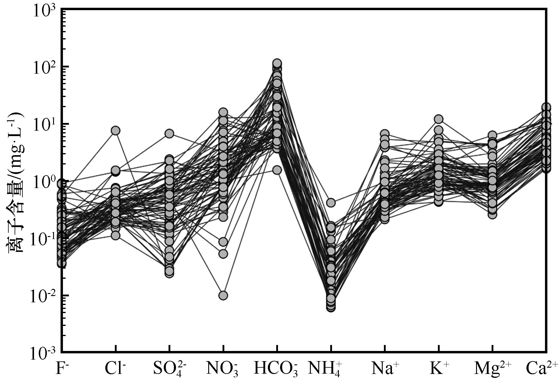
图2 易溶盐各离子的分布特征
Fig.2 Distribution patterns of soluble salts ions
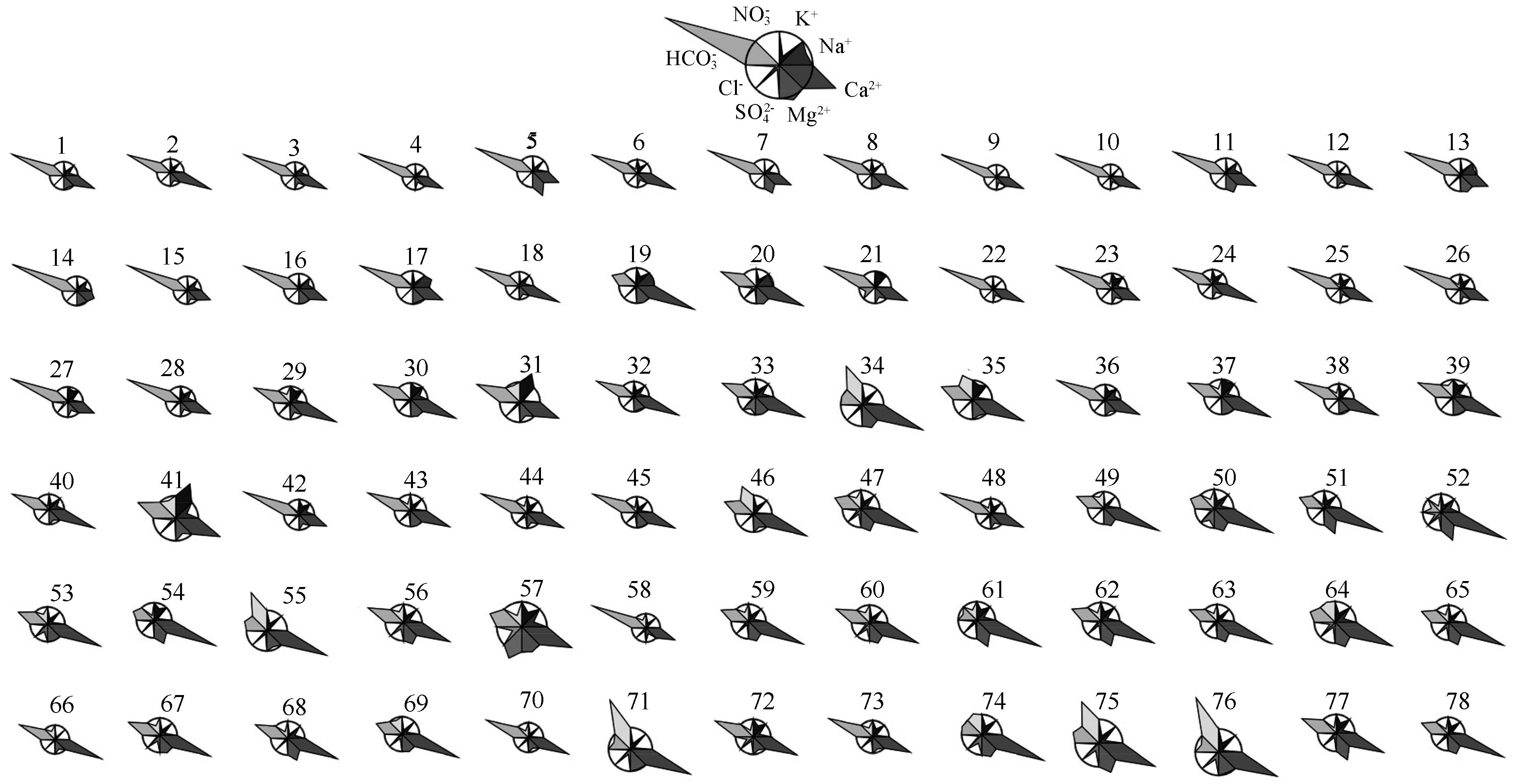
图3 Maucha图指示的易溶盐离子的绝对含量和相对含量
Fig.3 The absolute and relative contents of soluble salt ions indicated by the Maucha diagram
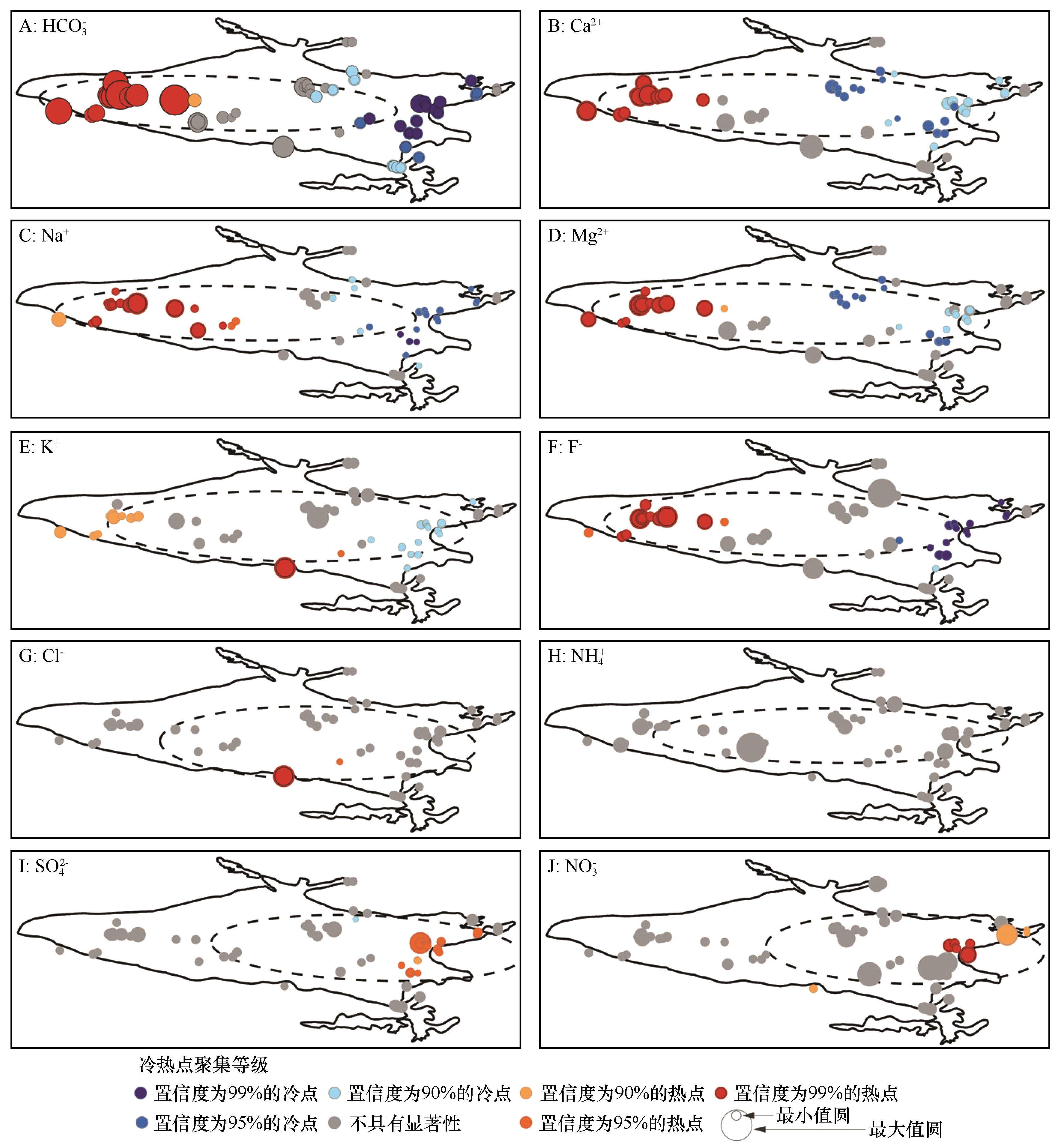
图4 易溶盐10种离子冷热点及标准差椭圆空间分布格局注:圆的直径大小表示各离子的含量。因不同离子含量差异较大,故进行了归一化处理,用最小值圆表示各离子含量的最小值,用最大值圆表示各离子含量的最大值
Fig.4 Cold-hot spots and standard deviational ellipse distribution of ten soluble salt ions
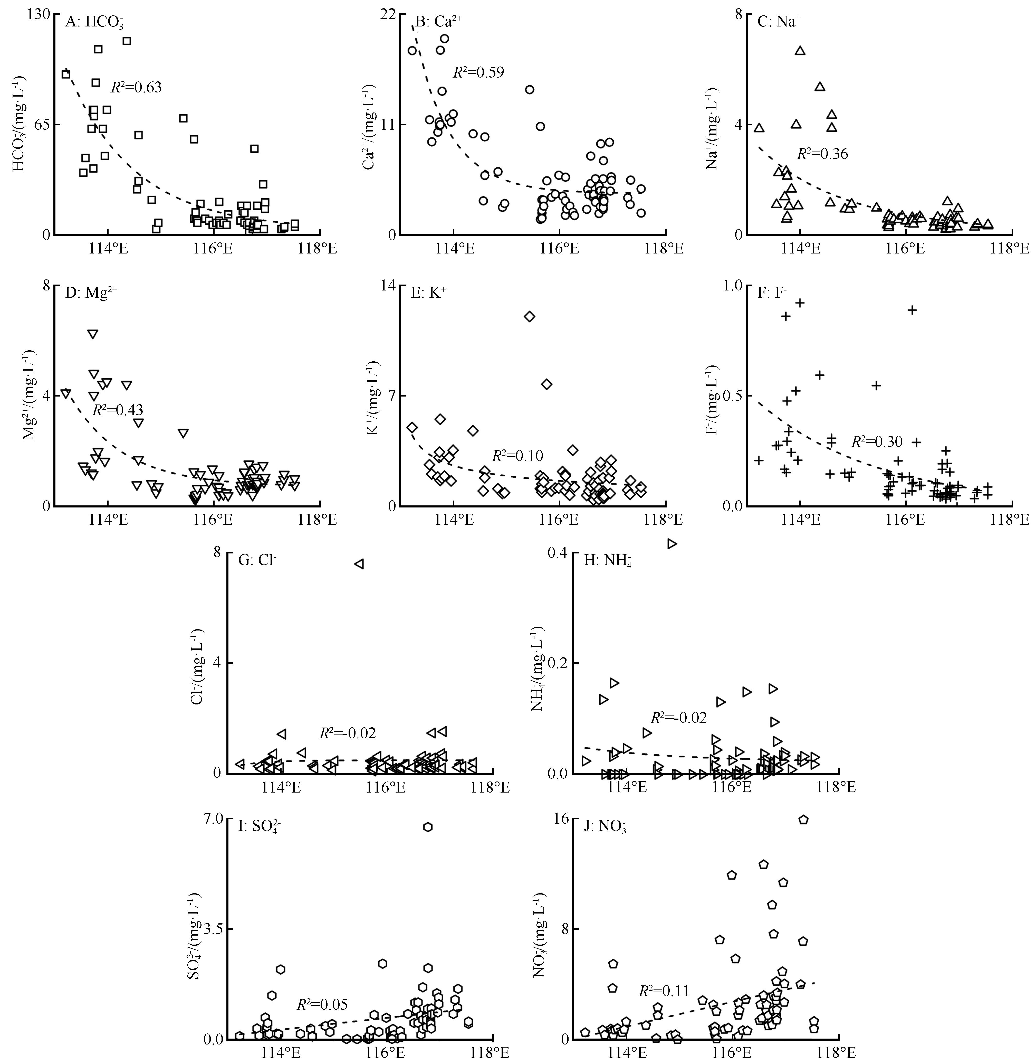
图5 经度与地表沉积物10种易溶盐离子含量的关系
Fig.5 Correlations between longitude and contents of ten soluble salt ions
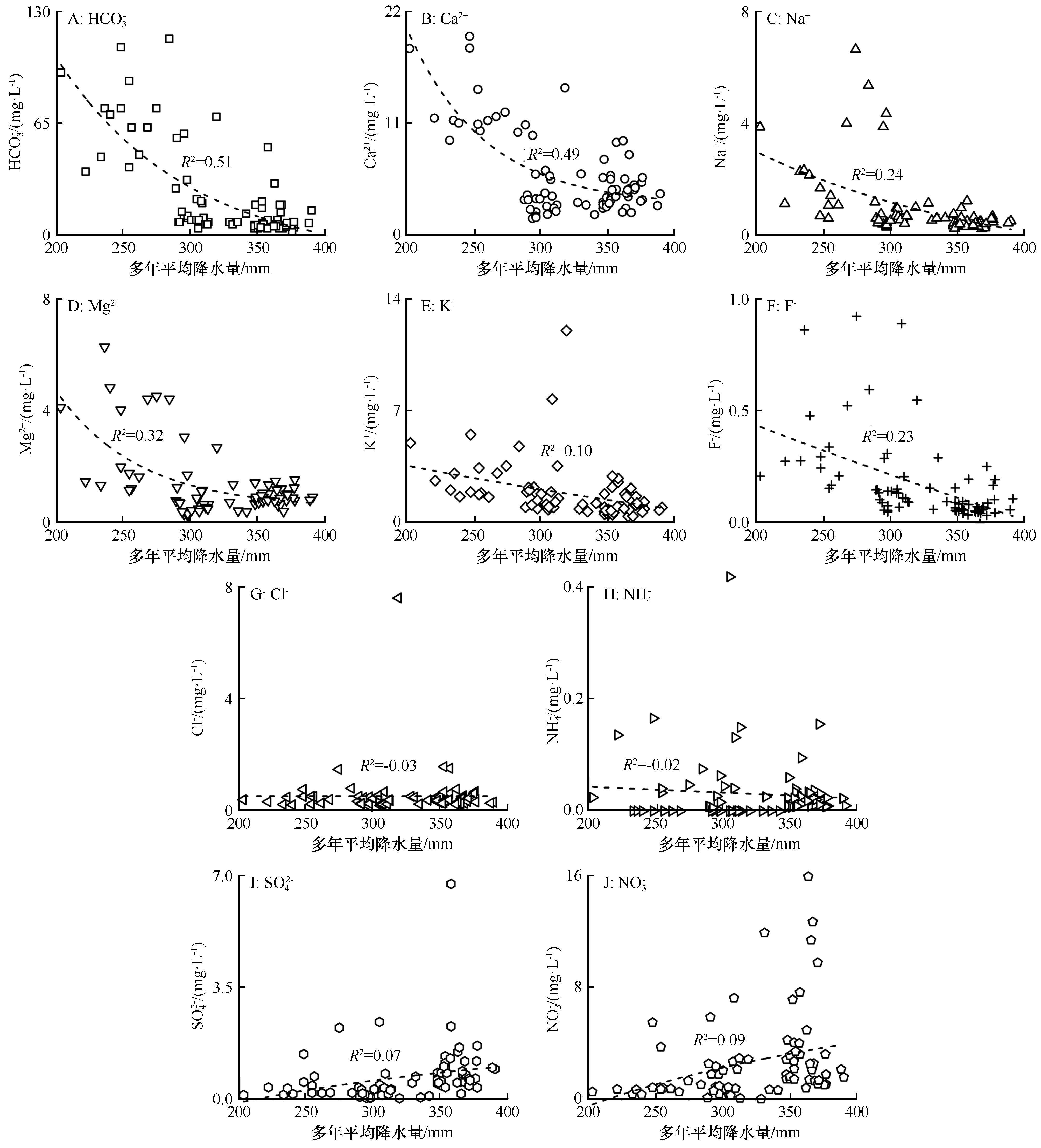
图6 多年平均降水量与10种易溶盐离子含量的关系
Fig.6 Correlations between annual mean precipitation and contents of ten soluble salt ions
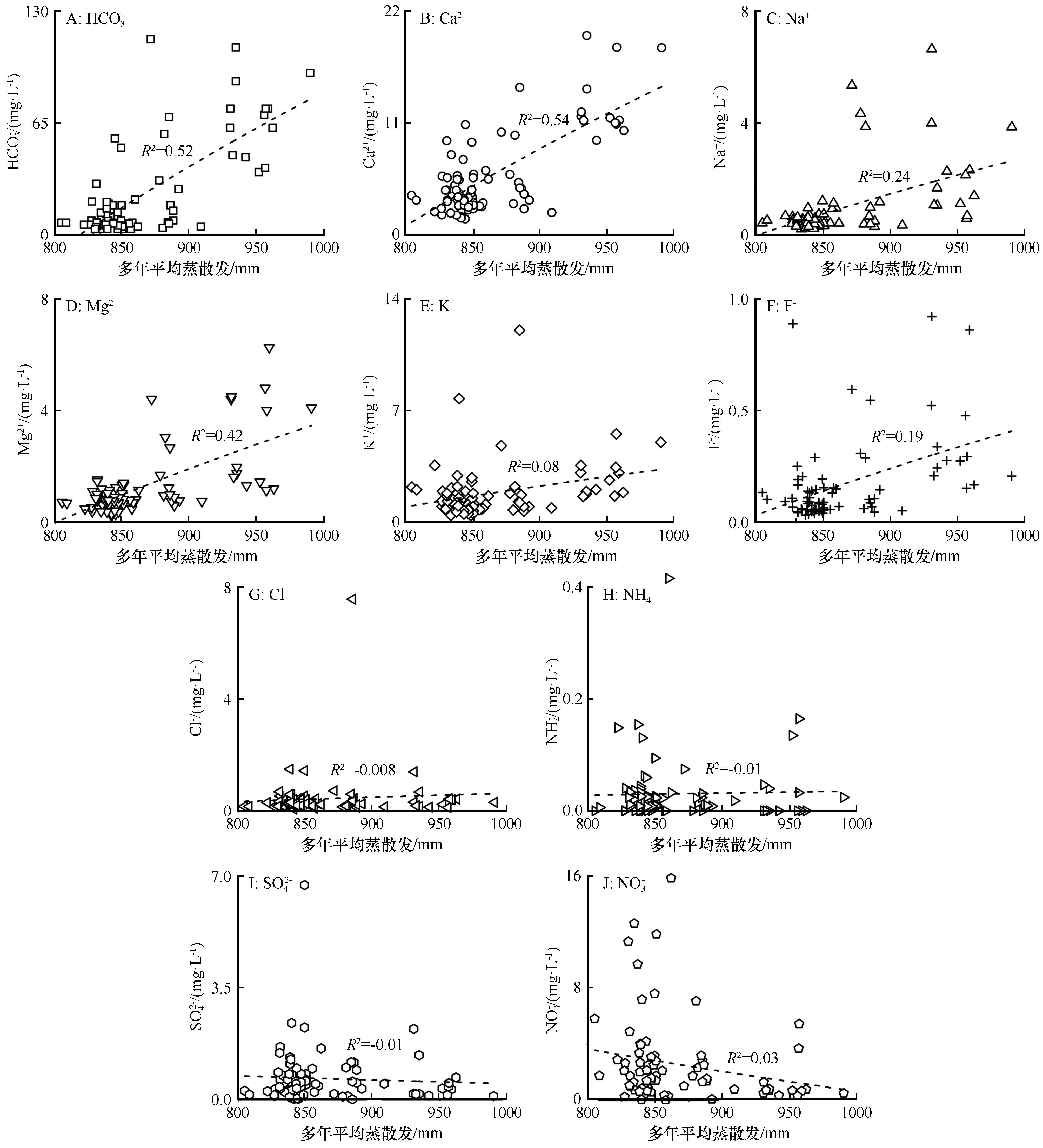
图7 多年平均蒸散发与10种易溶盐离子含量的关系
Fig.7 Correlations between annual mean evapotranspiration and contents of ten soluble salt ions
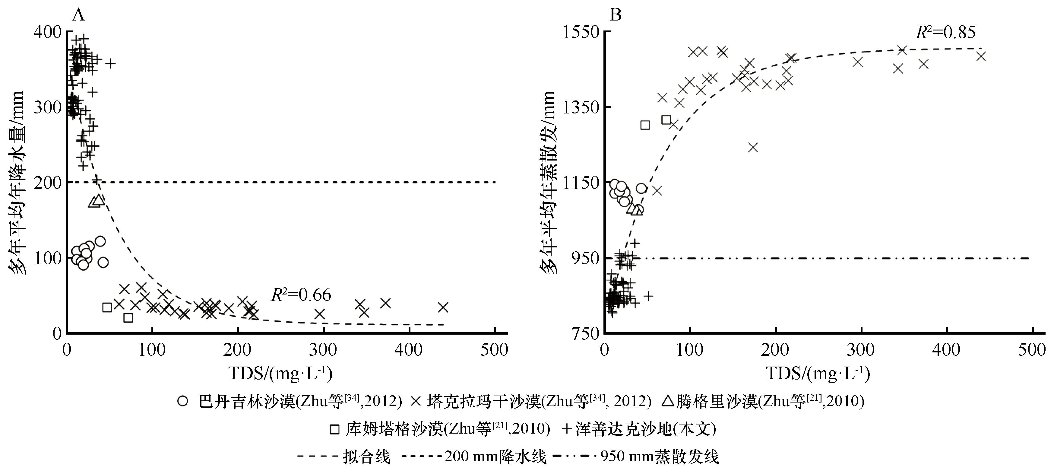
图8 沙漠地表沉积物易溶盐的TDS-气候要素双变量图
Fig.8 Bivariate relationship between TDS of soluble salt and climatic factors in surface desert sediments
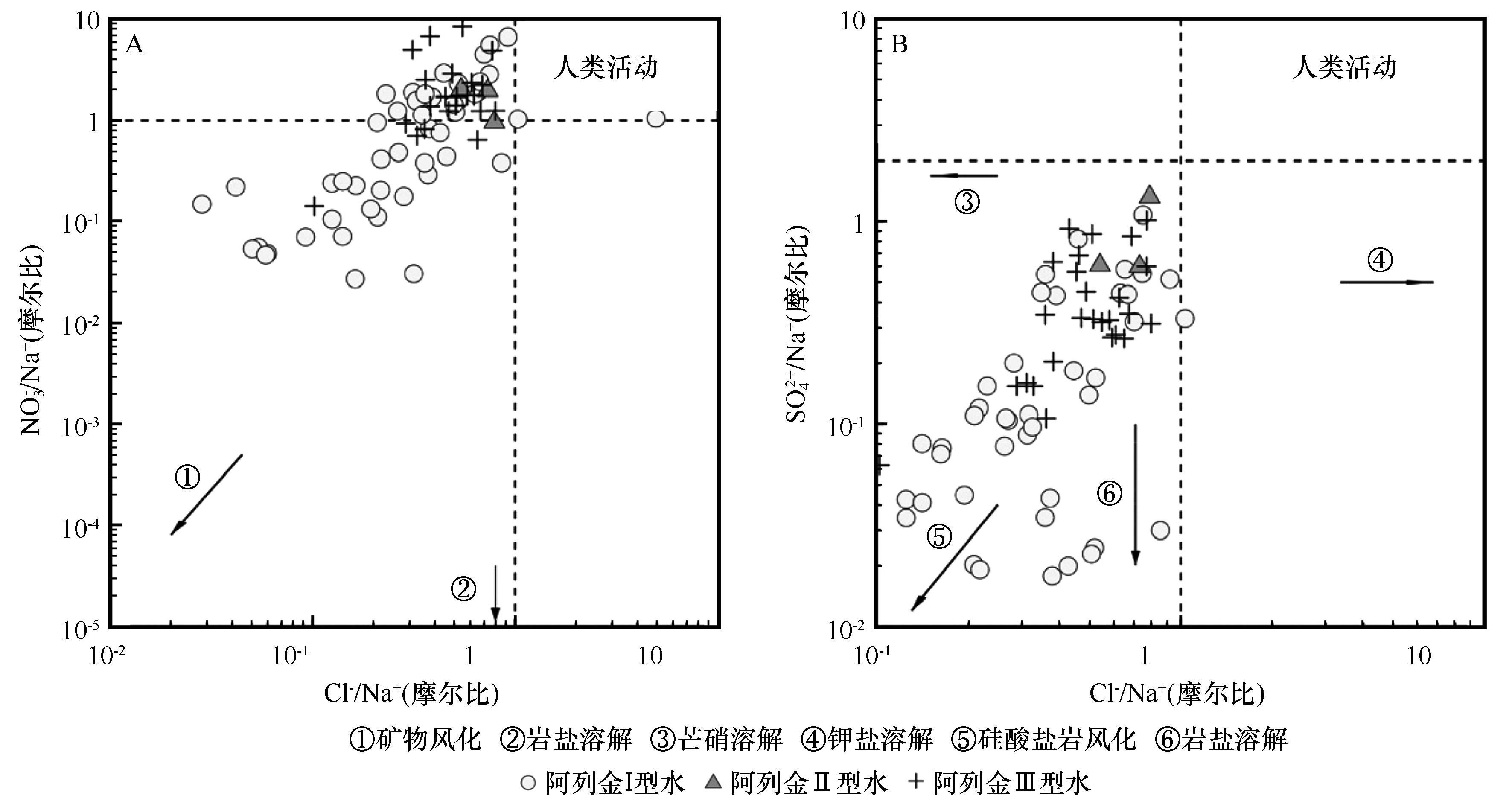
图9 易溶盐离子比值双变量图指示的人类活动情况
Fig.9 Human activities indicated by ion ratios of soluble salts in bivariate diagrams
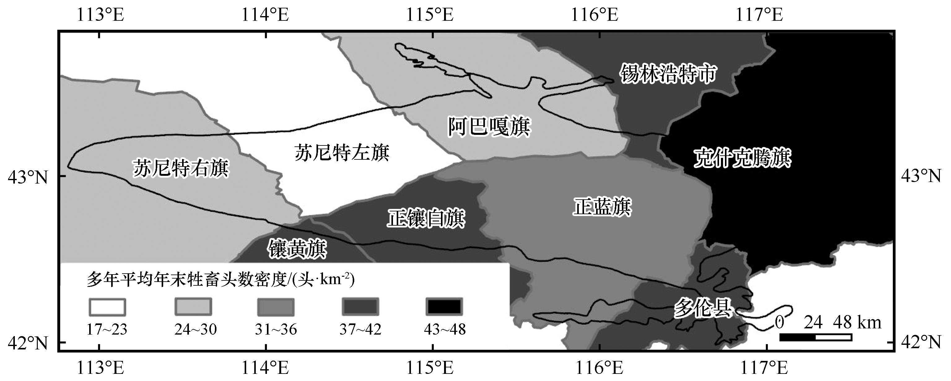
图10 多年平均年末牲畜头数密度分布格局(2009—2019年)注:多年平均年末牲畜头数密度(2009—2019年)基于历年《锡林浩特市统计年鉴》和《赤峰市统计年鉴》
Fig.10 Distribution pattern of year-end livestock density (2009-2019)
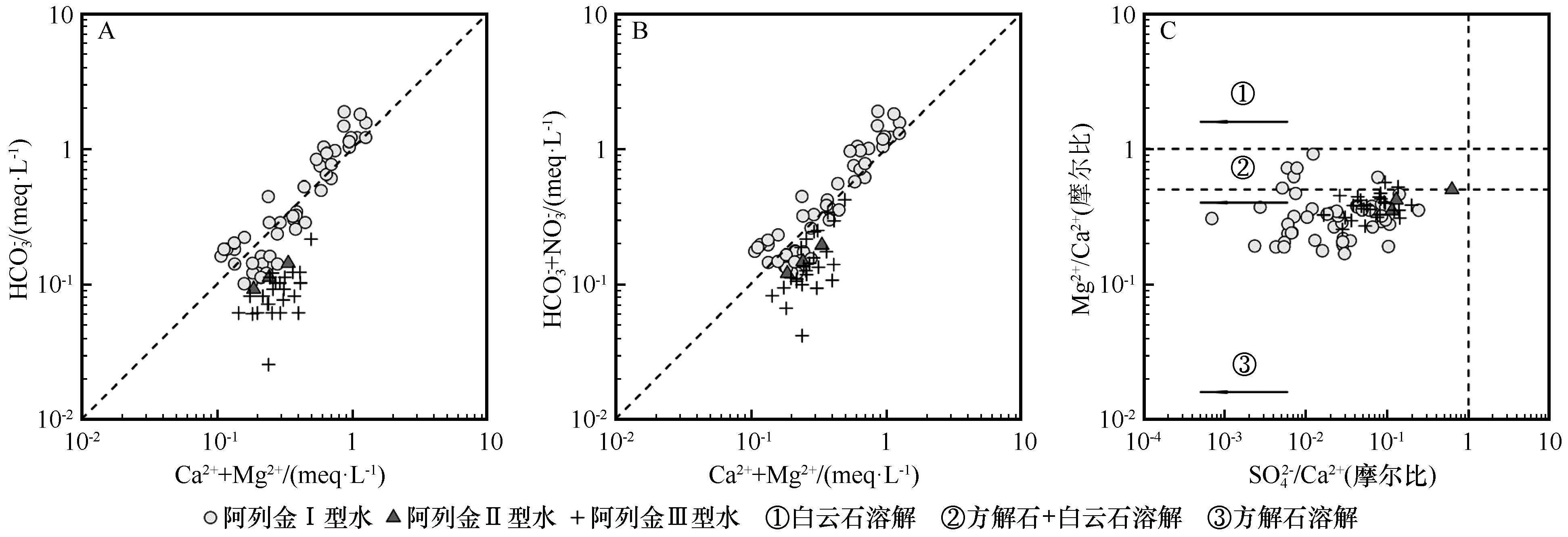
图11 易溶盐离子/离子比值双变量图指示的Ca2+、Mg2+与HCO3-的来源
Fig.11 Sources of Ca2+, Mg2+ and HCO3- indicated by ions /ion ratios of soluble salts in bivariate diagrams
| [1] | Li C, Ji H.Chemical weathering and the role of sulfuric and nitric acids in carbonate weathering:Isotopes (13C,15N,34S,and 18O) and chemical constraints[J].Journal of Geophysical Research:Biogeosciences,2016,121(5):1288-1305. |
| [2] | Liu J, Han G.Major ions and δ34SSO4 in Jiulongjiang River water:Investigating the relationships between natural chemical weathering and human perturbations[J].Science of The Total Environment,2020,724:138208. |
| [3] | 刘东生,等.黄土与环境[M].北京:科学出版社,1985. |
| [4] | Griffin D W, Kellogg C A.Dust storms and their impact on ocean and human health:dust in Earth's atmosphere[J].EcoHealth,2004,1(3):284-295. |
| [5] | Li W, Zhou Y, Zhang W,et al.A Review of water-soluble ions in natural dust particles over east Asia:abundance,spatial distributions,and implications[J].ACS ES&T Air,2025,2(8):1379-1393. |
| [6] | Goudie A S, Middleton N J.Desert Dust in the Global System[M].Berlin,Germany:Springer,2006. |
| [7] | Breckle S W, Yair A, Veste M.Arid Dune Ecosystems:The Nizzana Sands in the Negev Desert[M]. Berlin,Germany:Springer,2008. |
| [8] | Salem M A.Evaluation of salinity in some soils of irrigated Brack-Ashkada agriculture project,Fezzan,Libya[J].IOSR Journal of Agriculture and Veterinary Science,2013,2(1):5-9. |
| [9] | Maryol E, Lin C.Evaluation of atmospheric CO2 sequestration by alkaline soils through simultaneous enhanced carbonation and biomass production[J].Geoderma,2015,241:24-31. |
| [10] | Marion G, Verburg P, Mcdonald E,et al.Modeling salt movement through a Mojave Desert soil[J].Journal of Arid Environments,2008,72(6):1012-1033. |
| [11] | Bourrié G.Salts in deserts[M]//Joly F,Bourrié G.Mankind and Deserts 2:Water and Salts.London,UK:ISTE Ltd,2021. |
| [12] | Marion G M, Verburg P S J, Stevenson B,et al.Soluble element distributions in a Mojave Desert soil[J].Soil Science Society of America Journal,2008,72(6):1815-1823. |
| [13] | Pye K, Tsoar H.Aeolian Sand and Sand Dunes[M].Berlin,Germany:Springer,2009. |
| [14] | Kocurek G, Carr M, Ewing R,et al.White sands dune field,New Mexico:age,dune dynamics and recent accumulations[J].Sedimentary Geology,2007,197(3/4):313-331. |
| [15] | Glamoclija M, Ramirez S, Sirisena K,et al.Subsurface microbial ecology at sediment-groundwater interface in sulfate-rich Playa,White Sands National Monument,New Mexico[J].Frontiers in Microbiology,2019,10:2595. |
| [16] | Voigt C, Klipsch S, Herwartz D,et al.The spatial distribution of soluble salts in the surface soil of the Atacama Desert and their relationship to hyperaridity[J].Global and Planetary Change,2020,184:103077. |
| [17] | 朱震达,吴正,刘恕,等.中国沙漠概论[M].北京:科学出版社,1980. |
| [18] | 郭志清.我国沙漠地区沙丘的易溶盐含量分布特征[J].中国沙漠,1987,7(4):53-65. |
| [19] | 赵文智,荔克让,何欣东.我国不同地带沙地盐分特征研究[J].地理科学,1995,15(4):315-320. |
| [20] | 朱秉启,杨小平, Rioual P,等.沙漠风成沙的可溶盐组成及其环境意义[J].第四纪研究,2011,31(6):1029-1044. |
| [21] | Zhu B, Yang X.The origin and distribution of soluble salts in the sand seas of northern China[J].Geomorphology,2010,123(3/4):232-242. |
| [22] | 任孝宗,杨小平.浑善达克沙地沉积地层易溶盐的组成特征及其影响因素[J].中国沙漠,2026,46(2):177-187. |
| [23] | 杨小平,梁鹏,张德国,等.中国东部沙漠/沙地全新世地层序列及其古环境[J].中国科学:地球科学,2019,49(8):1293-1307. |
| [24] | Ren X, Zhu B, Liu M,et al.Mechanism of groundwater recharge in the middle-latitude desert of eastern Hunshandake,China:diffuse or focused recharge?[J].Hydrogeology Journal,2019,27(2):761-783. |
| [25] | Yang X, Wang X, Liu Z,et al.Initiation and variation of the dune fields in semi-arid China:with a special reference to the Hunshandake Sandy Land,Inner Mongolia[J].Quaternary Science Reviews,2013,78:369-380. |
| [26] | 靳鹤龄,苏志珠,孙良英,等.浑善达克沙地全新世气候变化[J].科学通报,2004,49(15):1532-1536. |
| [27] | Yang X, Li H, Conacher A.Large-scale controls on the development of sand seas in northern China[J].Quaternary International,2012,250:74-83. |
| [28] | Yang X, Zhu B, Wang X,et al.Late Quaternary environmental changes and organic carbon density in the Hunshandake Sandy Land,eastern Inner Mongolia,China[J].Global and Planetary Change,2008,61(1/2):70-78. |
| [29] | 中国科学院南京土壤研究所.土壤理化分析[M].上海:上海科学技术出版社,1978. |
| [30] | 孙宏日,刘艳军,周国磊.东北地区交通优势度演变格局及影响机制[J].地理学报,2021,76(2):444-458. |
| [31] | 郭向阳,穆学青,丁正山,等.长三角多维城市化对PM2.5浓度的非线性影响及驱动机制[J].地理学报,2021,76(5):1274-1293. |
| [32] | 任孝宗.水化学图形表达方法、MATLAB实现及在天然水体中的应用[M].西安:西安交通大学出版社,2021. |
| [33] | Appelo C a J, Postma D.Geochemistry,Groundwater and Pollution[M].Amsterdam,Netherlands:Taylor & Francis,2005. |
| [34] | Zhu B, Yang X, Liu Z,et al.Geochemical compositions of soluble salts in aeolian sands from the Taklamakan and Badanjilin deserts in northern China,and their influencing factors and environmental implications[J].Environmental Earth Sciences,2012,66(1):337-353. |
| [35] | Pariente S.Soluble salts dynamics in the soil under different climatic conditions[J].Catena,2001,43(4):307-321. |
| [36] | Rao W, Jin K, Jiang S,et al.Chemical and strontium isotopic characteristics of shallow groundwater in the Ordos Desert Plateau,North China:implications for the dissolved Sr source and water-rock interactions[J].Chemie der Erde,2015,75(3):365-374. |
| [37] | Zhang Y, Xu W, Wen Z,et al.Atmospheric deposition of inorganic nitrogen in a semi-arid grassland of Inner Mongolia,China[J].Journal of Arid Land,2017,9(6):810-822. |
| [38] | Feng H, Dong S, Li Y,et al.Characterizing nitrogen distribution,source and transformation in groundwater of ecotone of agriculture-animal husbandry:an example from North China[J].Environmental Earth Sciences,2020,79(6):133. |
| [39] | Tagma T, Hsissou Y, Bouchaou L,et al.Groundwater nitrate pollution in Souss-Massa basin (south-west Morocco)[J].African Journal of Environmental Science and Technology,2009,3(10):301-309. |
| [40] | Zhang C, Qiong W, Peng L.Investigations on nitrate pollution of soil,groundwater and vegetable from three typical farmlands in Beijing region,China[J].Agricultural Sciences in China,2011,10(3):423-430. |
| [41] | Hakeem K R, Sabir M, Ozturk M,et al.Nitrate and nitrogen oxides:sources,health effects and their remediation[J].Reviews of Environmental Contamination and Toxicology,2016,242:183-217. |
| [42] | 任孝宗.浑善达克沙地天然水体的水化学及水-沙相互作用研究[D].北京:中国科学院大学, 2014 |
| [43] | 马永桃,任孝宗,胡慧芳,等.基于地理探测器的浑善达克沙地植被变化定量归因[J].中国沙漠,2021,41(4):195-204. |
| [44] | Ma X, Wang S, Jiang G,et al.Short-term effect of targeted placements of sheep excrement on grassland in Inner Mongolia on soil and plant parameters[J].Communications in Soil Science and Plant Analysis,2007,38(11/12):1589-1604. |
| [45] | 任孝宗,李建刚,刘敏,等.浑善达克沙地东部地区天然水体的水化学组成及其控制因素[J].干旱区研究,2019,36(4):791-800. |
| [46] | Alezabawy A K, Eissa M, E-S Salem Z.Hydrogeochemical and isotopic investigations of groundwater in the reclaimed desert located between EL Nasr canal and Mariut Tableland,NW Coast,Egypt[J].Scientific Reports,2024,14(1):21172. |
| [47] | Rao W, Han G, Tan H,et al.Chemical and Sr isotopic characteristics of rainwater on the Alxa Desert Plateau,North China:Implication for air quality and ion sources[J].Atmospheric Research,2017,193:163-172. |
| [48] | Li H, Yang X, Scuderi L A,et al.East Gobi megalake systems reveal East Asian Monsoon dynamics over the last interglacial-glacial cycle[J].Nature Communications,2023,14(1):2103. |
| [49] | Yang X, Scuderi L A, Wang X,et al.Groundwater sapping as the cause of irreversible desertification of Hunshandake Sandy Lands,Inner Mongolia,northern China[J].Proceedings of the National Academy of Sciences,2015,112(3):702-706. |
| [50] | 白雪梅,春喜,斯琴毕力格,等.近45a内蒙古浑善达克沙地湖泊群的变化[J].湖泊科学,2016,28(5):1086-1094. |
| [51] | Maryol E, Lin C.Geochemical characteristics of soils in Fezzan,Sahara desert:Implications for environment and agriculture[J].Journal of Geochemical Exploration,2015,158:122-131. |
| [52] | Li R, Cui L, Zhao Y,et al.Wet deposition of inorganic ions in 320 cities across China:spatio-temporal variation,source apportionment,and dominant factors[J].Atmospheric Chemistry and Physics,2019,19(17):11043-11070. |
| [53] | Liu Z, Yang X.Geochemical-geomorphological Evidence for the provenance of aeolian sands and sedimentary environments in the Hunshandake Sandy Land,eastern Inner Mongolia,China[J].Acta Geologica Sinica,2013,87(3):871-884. |
| [1] | 鹿晨昱, 段庄慧, 张劲松, 赵文婧. 黄河流域甘肃段农业绿色发展效率综合测度及影响因素[J]. 中国沙漠, 2026, 46(4): 147-159. |
| [2] | 雷云竹, 王思琦, 韩兰英, 张思豆, 胡光印, 李超, 董治宝, 乌力吉德力格尔, 张文慧, 张正偲. 阿拉善高原东部戈壁区地表沉积物粒度特征[J]. 中国沙漠, 2026, 46(3): 11-21. |
| [3] | 任孝宗, 杨小平. 浑善达克沙地沉积地层易溶盐的组成特征及其影响因素[J]. 中国沙漠, 2026, 46(2): 177-187. |
| [4] | 严云籍, 白飞, 张加琼, 安鑫, 范晓强, 王椰. 1982—2020年黄土高原水蚀风蚀交错带土壤风蚀的时空变化及其主控因素[J]. 中国沙漠, 2026, 46(2): 336-347. |
| [5] | 张胜男, 高海燕, 闫德仁, 李俊文, 杨制国, 黄海广, 张雷, 许宏斌. 植被恢复策略对沙地土壤细菌群落结构及潜在功能的影响[J]. 中国沙漠, 2025, 45(5): 1-12. |
| [6] | 王录仓, 屈艳琦. 基于双维视角的黄河上游地区人口收缩特征及其影响因素[J]. 中国沙漠, 2025, 45(5): 181-193. |
| [7] | 陈雪萍, 赵学勇, 庄海艳, 乔宇来, 于红梅, 张晶. 内蒙古奈曼旗1985—2020年地下水埋深时空变化特征[J]. 中国沙漠, 2025, 45(4): 166-175. |
| [8] | 萨仁高娃, 赵媛媛, 耿鑫智, 王岳, 高广磊. 内蒙古沙区2000—2020年人地系统可持续性[J]. 中国沙漠, 2025, 45(2): 71-82. |
| [9] | 娄俊鹏, 蔡迪文, 马文勇, 焦琳琳. 浑善达克沙地风蚀物粒度和元素分异特征[J]. 中国沙漠, 2024, 44(5): 143-154. |
| [10] | 张悦仪, 迟云平, 谢远云, 康春国, 刘若男, 孙磊, 吴鹏, 魏振宇. 科尔沁沙地地表沉积物特征及其气候意义[J]. 中国沙漠, 2024, 44(4): 223-235. |
| [11] | 花丛, 曹云, 王继康, 徐冉. 2000—2023年浑善达克沙地春季沙尘天气分布特征及其与植被盖度、风况的关系[J]. 中国沙漠, 2024, 44(4): 71-80. |
| [12] | 张明斗, 杨雨欣. 黄河流域城市产业结构生态化的时空格局及影响因素[J]. 中国沙漠, 2024, 44(3): 108-118. |
| [13] | 杜佳瑜, 刘宪锋, 孙高鹏, 李双双. 2003—2018年黄土高原植被光学厚度时空变化及其影响因素[J]. 中国沙漠, 2024, 44(3): 222-230. |
| [14] | 梁晓磊, 程志花, 翟晓慧, 牛清河, 张益明, 李艳丽. 敦煌雅丹地层易溶盐特征及其对沉积环境的指示意义[J]. 中国沙漠, 2024, 44(2): 109-120. |
| [15] | 杨静, 郭群. 省级层面碳排放估算及减排路径方法研究[J]. 中国沙漠, 2023, 43(5): 176-185. |
| 阅读次数 | ||||||
|
全文 |
|
|||||
|
摘要 |
|
|||||
©2018中国沙漠 编辑部
地址: 兰州市天水中路8号 (730000)
电话:0931-8267545
Email:caiedit@lzb.ac.cn;desert@lzb.ac.cn


 甘公网安备 62010202000688号