img

官方微信

高级检索

中国沙漠 ›› 2025, Vol. 45 ›› Issue (4): 166-175.DOI: 10.7522/j.issn.1000-694X.2025.00164

• • 上一篇    

内蒙古奈曼旗19852020年地下水埋深时空变化特征

陈雪萍1,2,4(), 赵学勇1,2,4, 庄海艳5, 乔宇来5, 于红梅6, 张晶3   

  1. 1.中国科学院西北生态环境资源研究院,干旱区生态安全与可持续发展全国重点实验室,甘肃 兰州 730000
    2.中国科学院西北生态环境资源研究院,奈曼沙漠化研究站,甘肃 兰州 730000
    3.中国科学院西北生态环境资源研究院,文献情报中心,甘肃 兰州 730000
    4.中国科学院大学,北京 100049
    5.奈曼旗水务局,内蒙古 通辽 028300
    6.赤峰水文水资源分中心,内蒙古 赤峰 024000
  • 收稿日期:2025-04-28 修回日期:2025-06-05 出版日期:2025-07-20 发布日期:2025-08-18
  • 作者简介:陈雪萍(1993—),女,甘肃靖远人,博士,研究方向为生态水文遥感。E-mail: chenxp0305@163.com
  • 基金资助:
    国家自然科学基金项目(42177456);内蒙古科技成果转化项目(2021CG0012)

Characteristics of groundwater depth in NaimanInner Mongolia in 1985-2020

Xueping Chen1,2,4(), Xueyong Zhao1,2,4, Haiyan Zhuang5, Yulai Qiao5, Hongmei Yu6, Jing Zhang3   

  1. 1.Key Laboratory of Ecological Safety and Sustainable Development in Arid Lands /, Northwest Institute of Eco-Environment and Resources,Chinese Academy of Sciences,Lanzhou 730000,China
    2.Naiman Desertification Research Station /, Northwest Institute of Eco-Environment and Resources,Chinese Academy of Sciences,Lanzhou 730000,China
    3.Literature and Information Center, Northwest Institute of Eco-Environment and Resources,Chinese Academy of Sciences,Lanzhou 730000,China
    4.University of Chinese Academy of Sciences,Beijing 100049,China
    5.Water Affairs Bureau of Naiman Banner,Tongliao 028000,Inner Mongolia,China
    6.Chifeng Hydrology and Water Resources Center,Chifeng 024000,Inner Mongolia,China
  • Received:2025-04-28 Revised:2025-06-05 Online:2025-07-20 Published:2025-08-18

摘要:

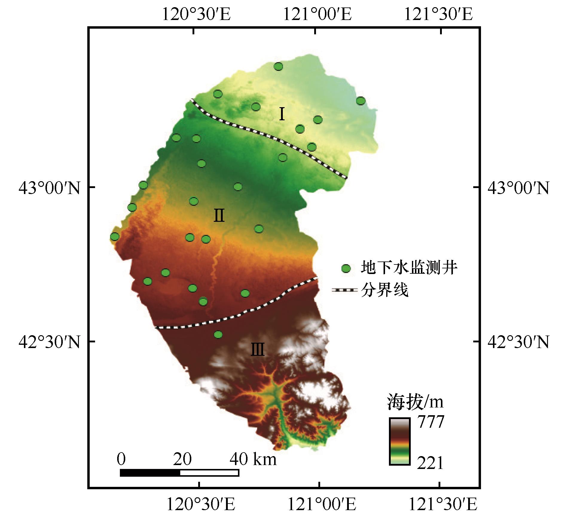
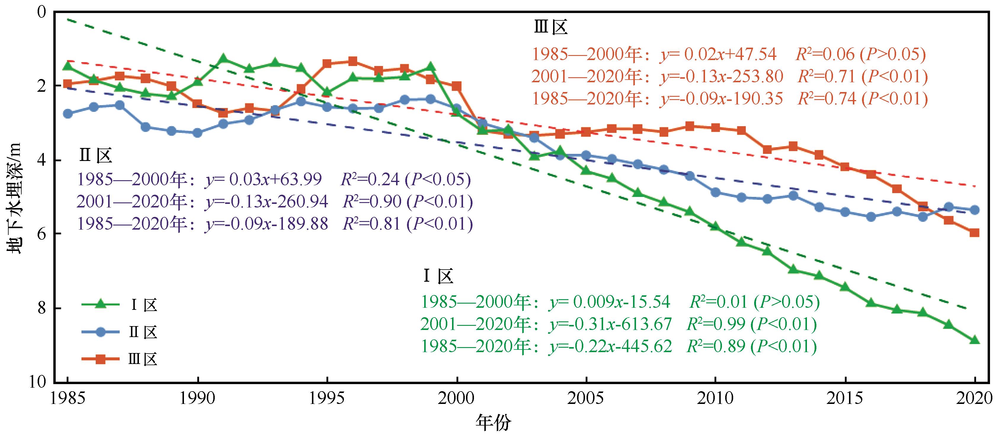
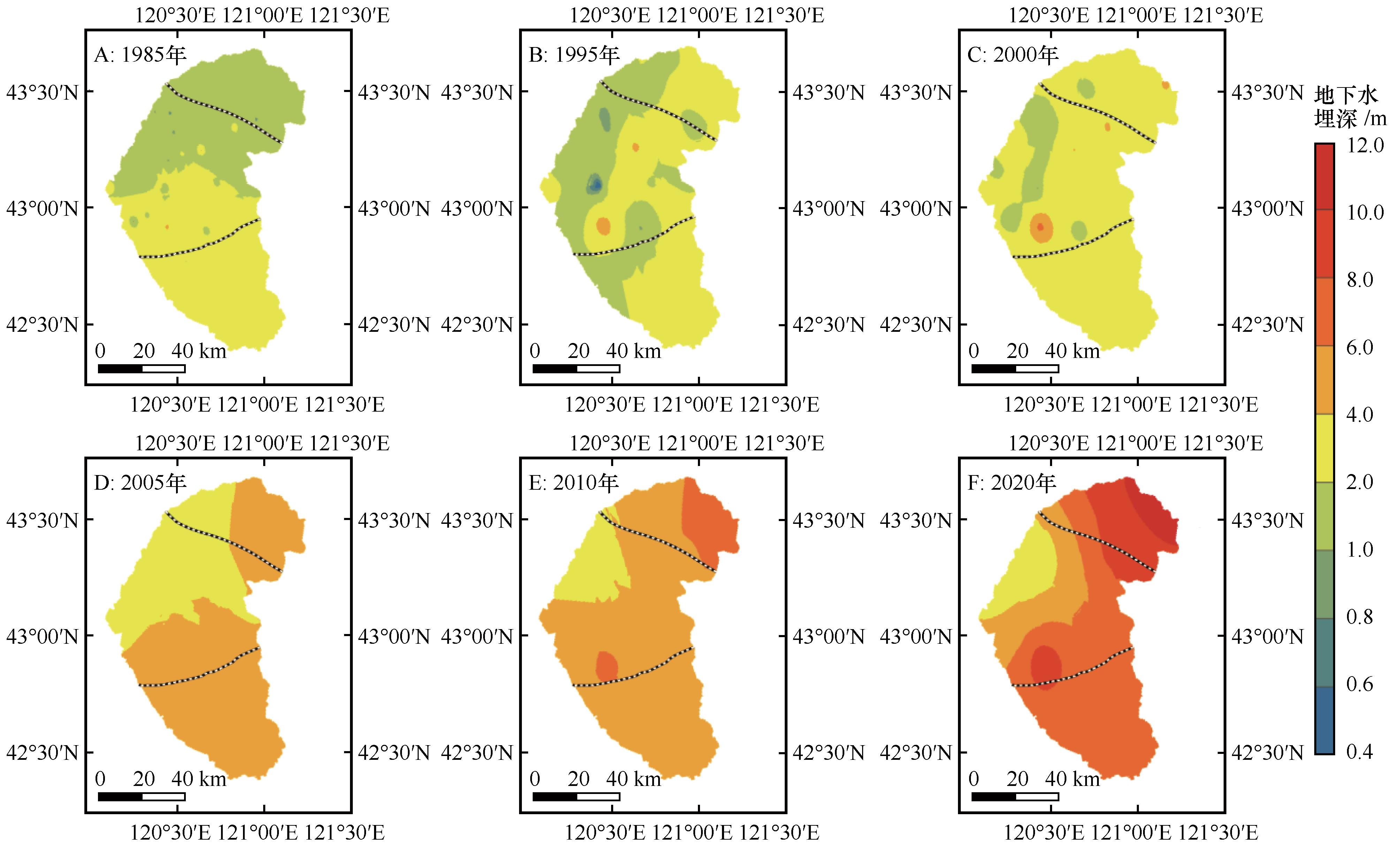
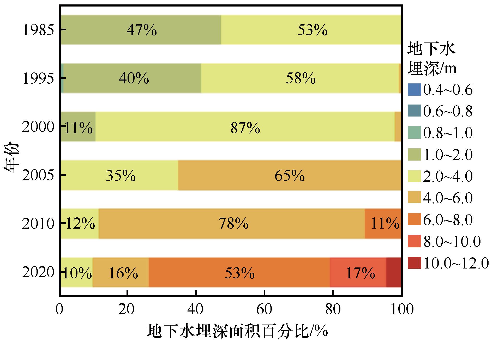
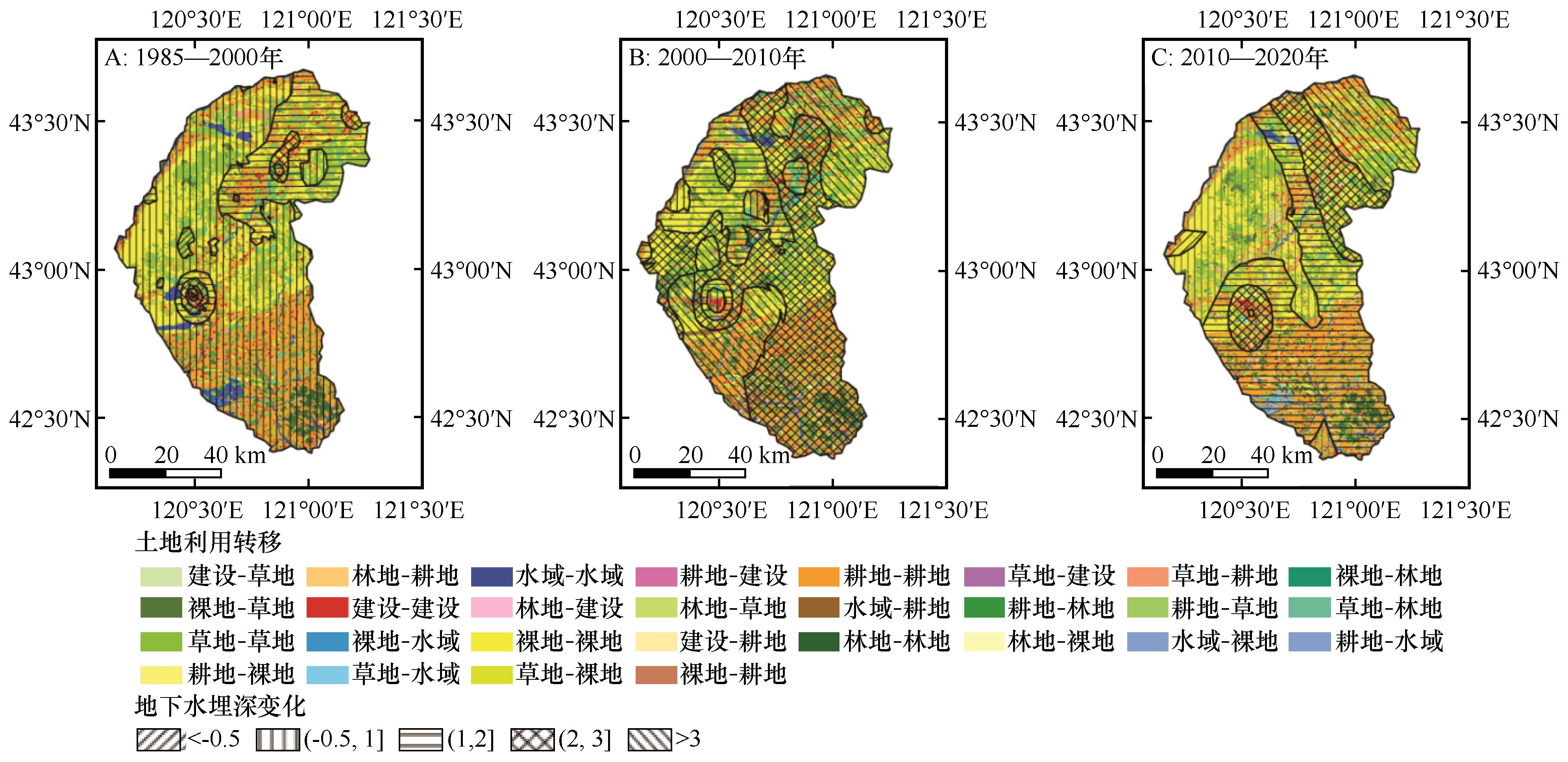
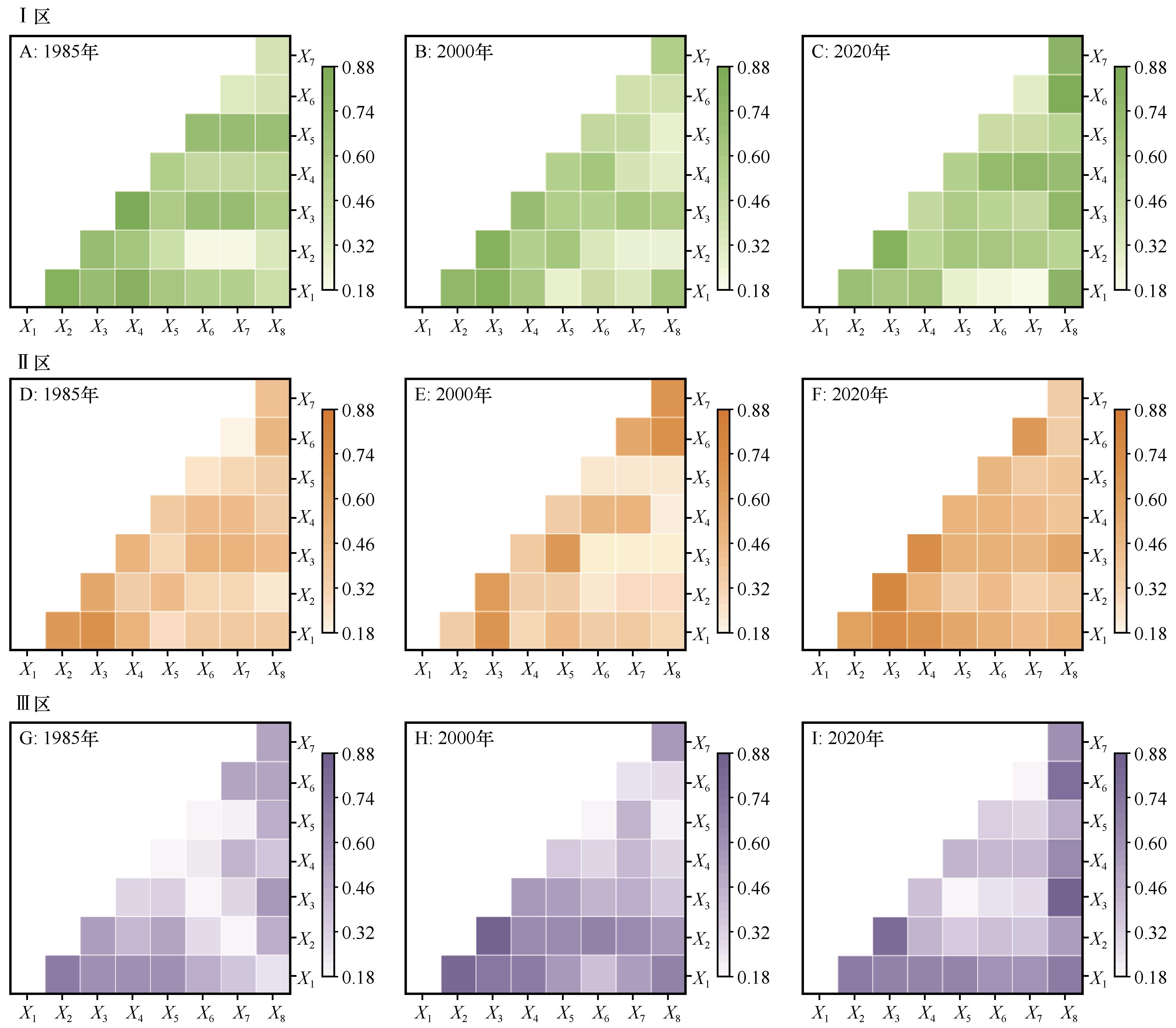
奈曼旗是中国北方半干旱农牧交错带重要的粮食生产基地,但近年来水资源供需矛盾日益突出。随着农业种植面积不断扩大,该旗地下水埋深持续增加,水资源短缺问题愈发严峻。本研究基于奈曼旗25眼地下水监测井长期观测数据,结合土地利用类型和海拔特征将研究区划为3个分区——I区北部农田区、II区中部沙地区和III区南部山地区,采用克里金插值法分析了1985—2020年地下水埋深时空演变特征及其影响因素。结果表明:(1)研究时段内奈曼旗地下水埋深整体呈增加趋势,1995—1999年因降水增加有所抬升。(2)各分区年内地下水埋深变化特征因地下水动态类型各有差异;年际特征上,I区增速(0.22 m·a-1)显著高于II区和III区(均为0.09 m·a-1),大沁他拉镇增幅最突出。(3)旗域内耕地-草地-裸地-建设用地之间的转化最为显著,特别是I区耕地扩张和II区城镇发展对地下水埋深变化具有决定性影响。(4)2000年前,各分区地下水埋深受气象因素交互作用显著;2000年后,I区灌溉面积与各驱动因子交互作用全面增强;II区维持以气温和蒸发为主导的交互模式;III区降水量和灌溉面积与各驱动因子交互作用逐渐增强。

关键词: 地下水埋深, 时空分布, 土地利用, 影响因素, 奈曼旗

Abstract:

Naiman Banner, a crucial grain production base in the semi-arid agro-pastoral ecotone of northern China, has been facing increasingly severe water resource shortages. With continuous expansion of agricultural land, the groundwater depth in this region has shown a persistent increasing trend. Based on long-term monitoring data from 25 groundwater observation wells, this study divided the study area into three subregions: Zone I (northern farmland), Zone II (central sandy area), and Zone III (southern mountainous area), according to land use and elevation characteristics. The spatiotemporal evolution of groundwater depth from 1985 to 2020 was analyzed using the Kriging interpolation method. The results indicate that: (1) Groundwater depth exhibited an overall increasing trend, with a temporary rise during 1995-1999 due to increased precipitation. (2) Seasonal variations in groundwater depth differed among subregions due to distinct dynamic patterns. Interannually, Zone I showed the fastest annual increase (0.22 m), significantly higher than Zone II and Zone III (both 0.09 m), with Daqintala Town experiencing the most pronounced rise. (3) Land use conversion among cropland, grassland, bare land, and built-up areas was most significant, particularly cropland expansion in Zone I and urban development in Zone II, which exerted decisive impacts on groundwater depth changes. (4) Before 2000, meteorological factors dominated groundwater depth variations across all subregions, whereas after 2000, interactions between irrigation area and other driving factors intensified in Zone I, while Zone II remained primarily influenced by temperature and evaporation, and Zone III showed increasing interactions between precipitation and irrigation area. This study provides a scientific basis for understanding groundwater dynamics in Naiman Banner and offers critical insights for regional water resource management and sustainable development.

Key words: groundwater depth, Spatial-temporal distribution, land use and land cover, influencing factor, Naiman Banner

中图分类号: