
- CN 62-1070/P
- ISSN 1000-694X
- Bimonthly 1981
Journal of Desert Research ›› 2023, Vol. 43 ›› Issue (6): 237-245.DOI: 10.7522/j.issn.1000-694X.2023.00095
Wangyizhuang Lv1,2( ), Wenzhi Zhao1,2()
Received:2022-12-03
Revised:2023-02-20
Online:2023-11-20
Published:2023-11-30
Contact:
Wenzhi Zhao
CLC Number:
Wangyizhuang Lv, Wenzhi Zhao. The structure and pattern of farmland shelterbelts in Jiuquan Oasis of Hexi Corridor[J]. Journal of Desert Research, 2023, 43(6): 237-245.
Add to citation manager EndNote|Ris|BibTeX
URL: http://www.desert.ac.cn/EN/10.7522/j.issn.1000-694X.2023.00095
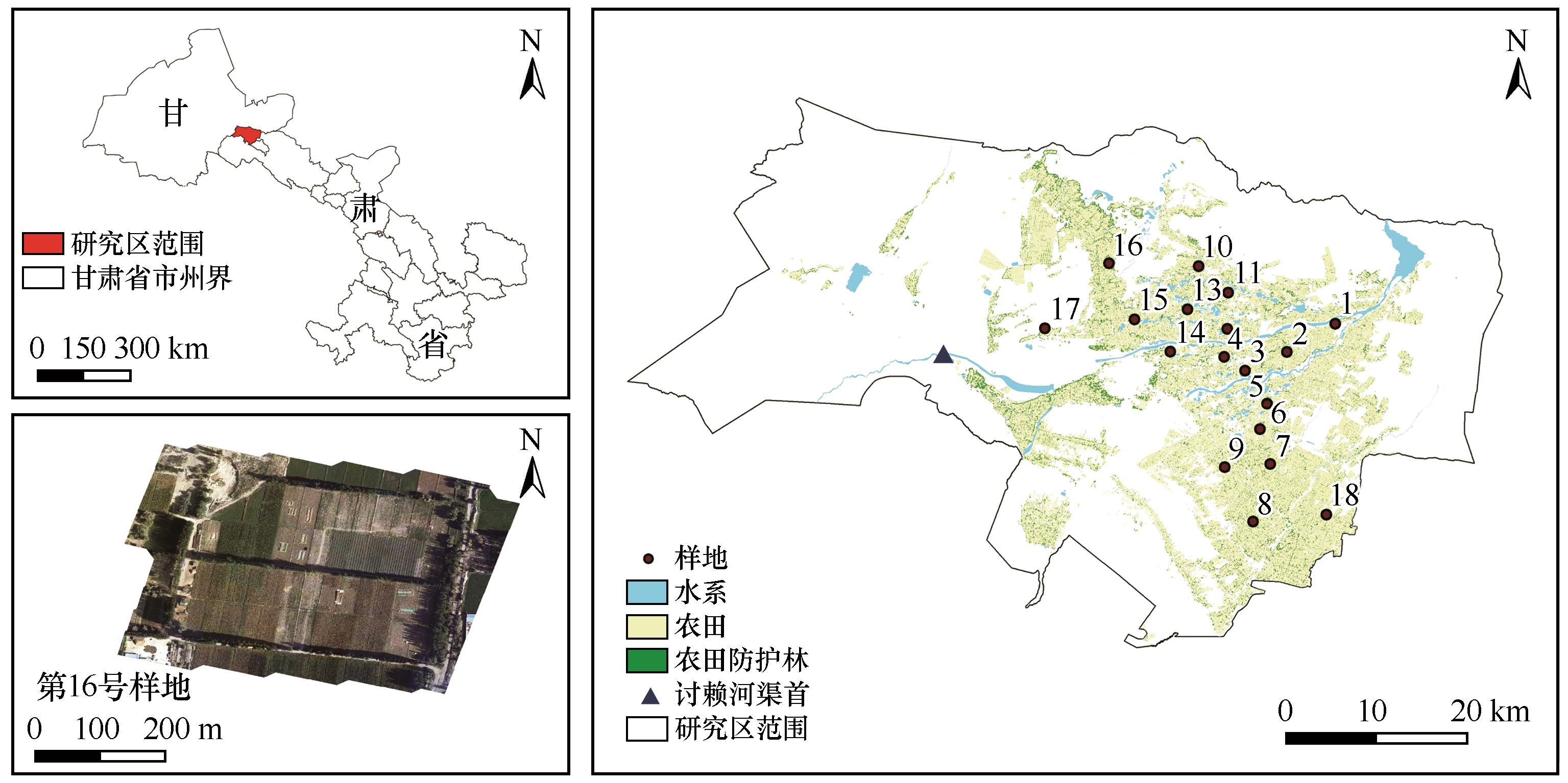
Fig.1 Location of the study area and distribution of sampling points
| 指标 | 因子含义 | 指标意义 | 公式 |
|---|---|---|---|
| 带斑比 | Sb 代表林网面积,A代表区域内需要被保护的农田面积 | 代表防护林的相对丰富度,数值越大则代表防护林在农田的占比越高 | |
| 完整度 指数 | i代表地类为林地,cijk 为在临界距离之内的林地j与k的连接状况;ni 为景观中林带的条数 | 代表该地块内防护林网的连续性,反映防护林形成条带或网状的完整程度,最大值为100,数值越大林网完整度越高 | |
| 疏透度 | 表示林带疏密状况和透风程度的指标。林带间隙越大则疏透度越大,疏透度达到1则代表不存在林带 |
Table 1 Parameter connotation and calculation method of pattern structure of farmland shelterbelts
| 指标 | 因子含义 | 指标意义 | 公式 |
|---|---|---|---|
| 带斑比 | Sb 代表林网面积,A代表区域内需要被保护的农田面积 | 代表防护林的相对丰富度,数值越大则代表防护林在农田的占比越高 | |
| 完整度 指数 | i代表地类为林地,cijk 为在临界距离之内的林地j与k的连接状况;ni 为景观中林带的条数 | 代表该地块内防护林网的连续性,反映防护林形成条带或网状的完整程度,最大值为100,数值越大林网完整度越高 | |
| 疏透度 | 表示林带疏密状况和透风程度的指标。林带间隙越大则疏透度越大,疏透度达到1则代表不存在林带 |
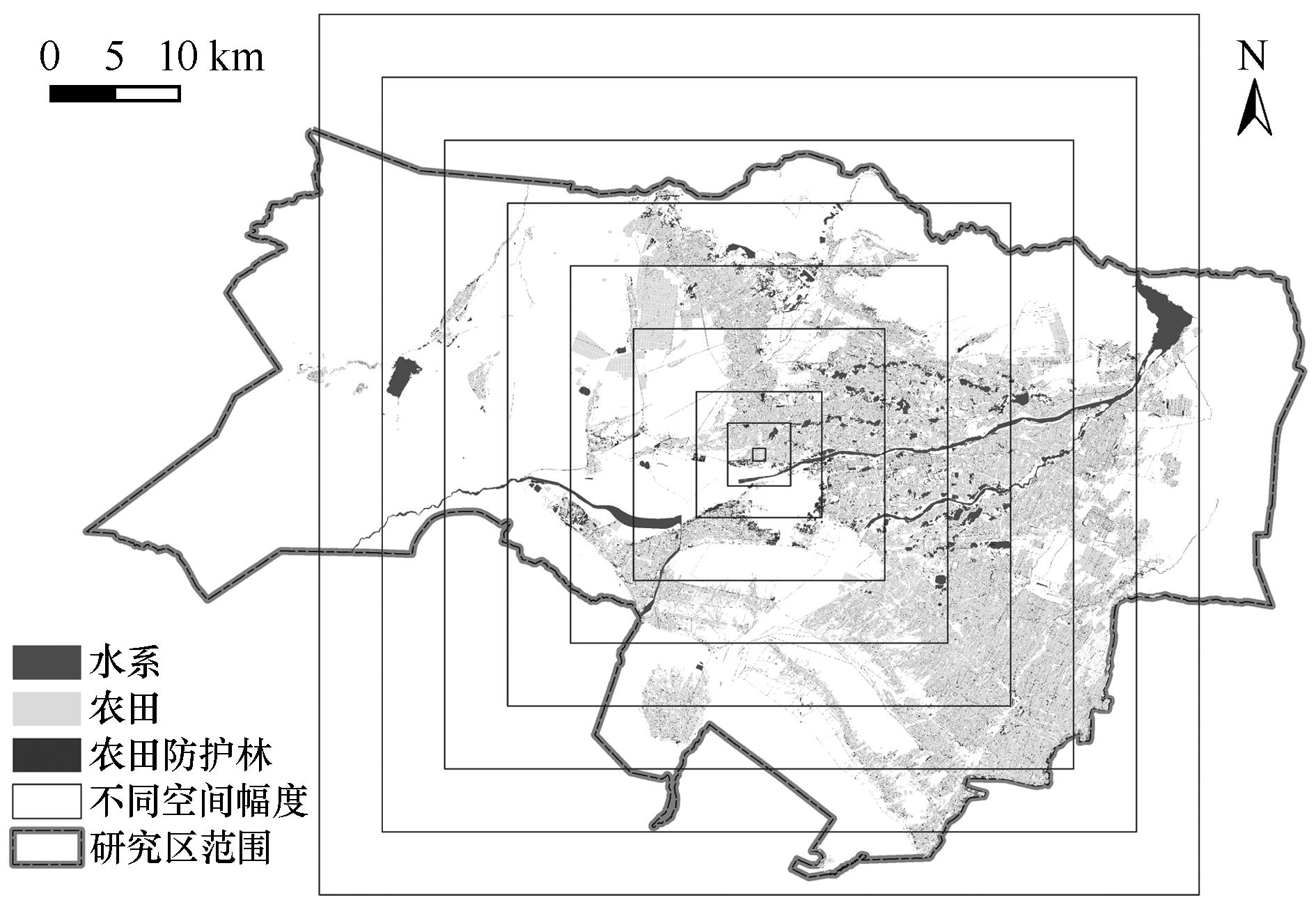
Fig.2 Scale effect of farmland shelterbelts on moving window method
| 样地序号 | 平均胸径/cm | 平均树高/m | 带斑比/% | 疏透度 |
|---|---|---|---|---|
| 1 | 20.4±1.76 | 15.7±1.27 | 7.72 | 0.78 |
| 2 | 19.7±0.90 | 16.9±0.26 | 1.93 | 0.56 |
| 3 | 23.8±1.83 | 20.4±0.55 | 4.09 | 0.88 |
| 4 | 45.5±3.67 | 15.0±0.90 | 2.31 | 0.85 |
| 5 | 26.9±1.10 | 13.3±1.53 | 5.71 | 0.82 |
| 6 | 22.0±1.17 | 17.6±1.64 | 3.70 | 0.53 |
| 7 | 19.2±0.78 | 20.9±0.58 | 11.42 | 0.24 |
| 8 | 25.8±1.97 | 20.2±0.84 | 3.61 | 0.77 |
| 9 | 24.3±1.06 | 20.4±0.64 | 5.48 | 0.44 |
| 10 | 21.8±1.51 | 17.2±1.95 | 2.57 | 0.69 |
| 11 | 30.8±0.97 | 20.1±0.53 | 4.31 | 0.62 |
| 12 | 24.3±0.51 | 21.3±1.00 | 3.81 | 0.76 |
| 13 | 31.7±1.29 | 21.9±0.68 | 3.54 | 0.84 |
| 14 | 35.1±1.16 | 18.9±0.62 | 6.34 | 0.82 |
| 15 | 22.7±0.95 | 15.7±0.49 | 2.35 | 0.27 |
| 16 | 20.3±0.93 | 17.2±1.40 | 12.52 | 0.25 |
| 17 | 15.4±0.85 | 14.7±0.57 | 2.45 | 0.51 |
| 18 | 32.6±3.18 | 8.3±0.68 | 6.88 | 0.92 |
Table 2 Statistical results of field survey
| 样地序号 | 平均胸径/cm | 平均树高/m | 带斑比/% | 疏透度 |
|---|---|---|---|---|
| 1 | 20.4±1.76 | 15.7±1.27 | 7.72 | 0.78 |
| 2 | 19.7±0.90 | 16.9±0.26 | 1.93 | 0.56 |
| 3 | 23.8±1.83 | 20.4±0.55 | 4.09 | 0.88 |
| 4 | 45.5±3.67 | 15.0±0.90 | 2.31 | 0.85 |
| 5 | 26.9±1.10 | 13.3±1.53 | 5.71 | 0.82 |
| 6 | 22.0±1.17 | 17.6±1.64 | 3.70 | 0.53 |
| 7 | 19.2±0.78 | 20.9±0.58 | 11.42 | 0.24 |
| 8 | 25.8±1.97 | 20.2±0.84 | 3.61 | 0.77 |
| 9 | 24.3±1.06 | 20.4±0.64 | 5.48 | 0.44 |
| 10 | 21.8±1.51 | 17.2±1.95 | 2.57 | 0.69 |
| 11 | 30.8±0.97 | 20.1±0.53 | 4.31 | 0.62 |
| 12 | 24.3±0.51 | 21.3±1.00 | 3.81 | 0.76 |
| 13 | 31.7±1.29 | 21.9±0.68 | 3.54 | 0.84 |
| 14 | 35.1±1.16 | 18.9±0.62 | 6.34 | 0.82 |
| 15 | 22.7±0.95 | 15.7±0.49 | 2.35 | 0.27 |
| 16 | 20.3±0.93 | 17.2±1.40 | 12.52 | 0.25 |
| 17 | 15.4±0.85 | 14.7±0.57 | 2.45 | 0.51 |
| 18 | 32.6±3.18 | 8.3±0.68 | 6.88 | 0.92 |
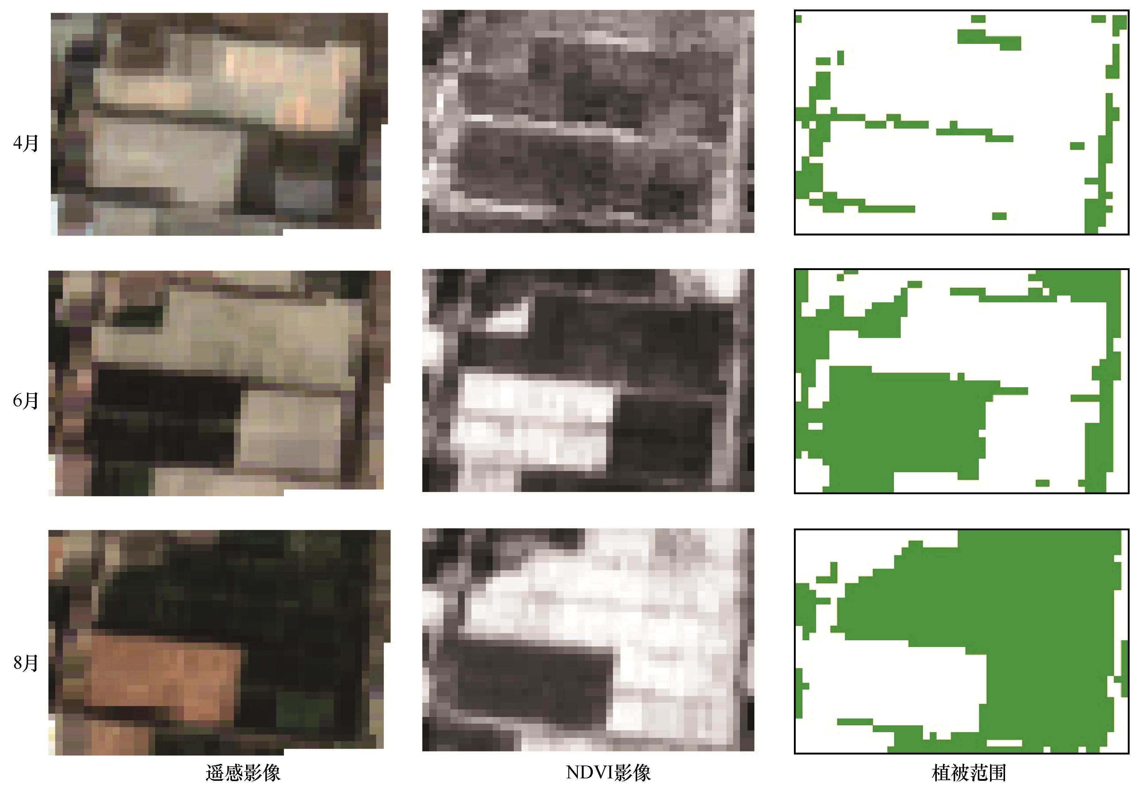
Fig.3 Remote sensing image and extraction of shelterbelts from April, June and August
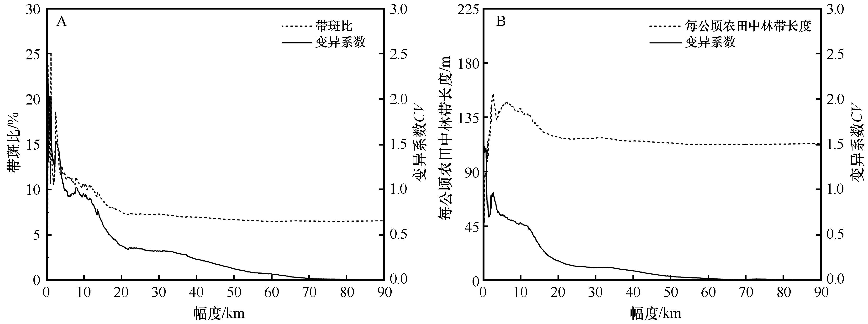
Fig.4 Scale effect of farmland shelterbelts structure
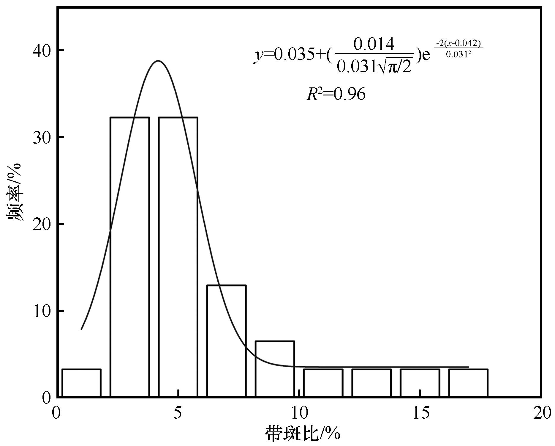
Fig.5 Frequency distribution of ration of belt to patch of field survey
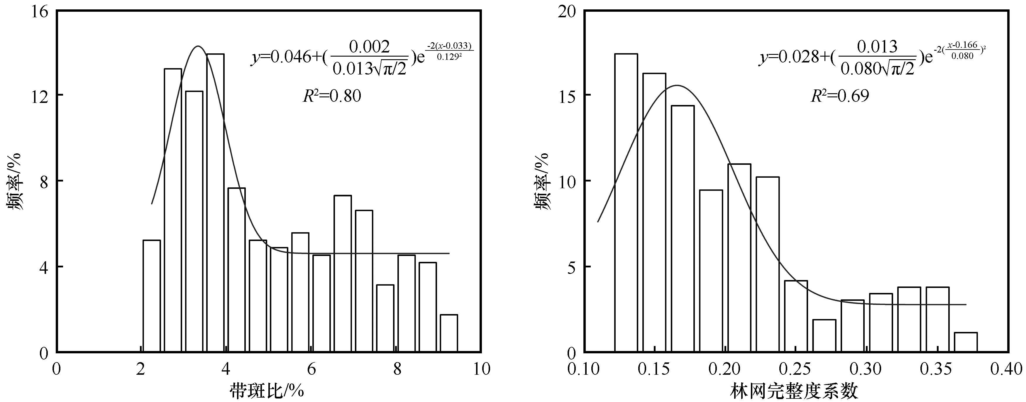
Fig.6 Frequency distribution of indexes at 2 km grain
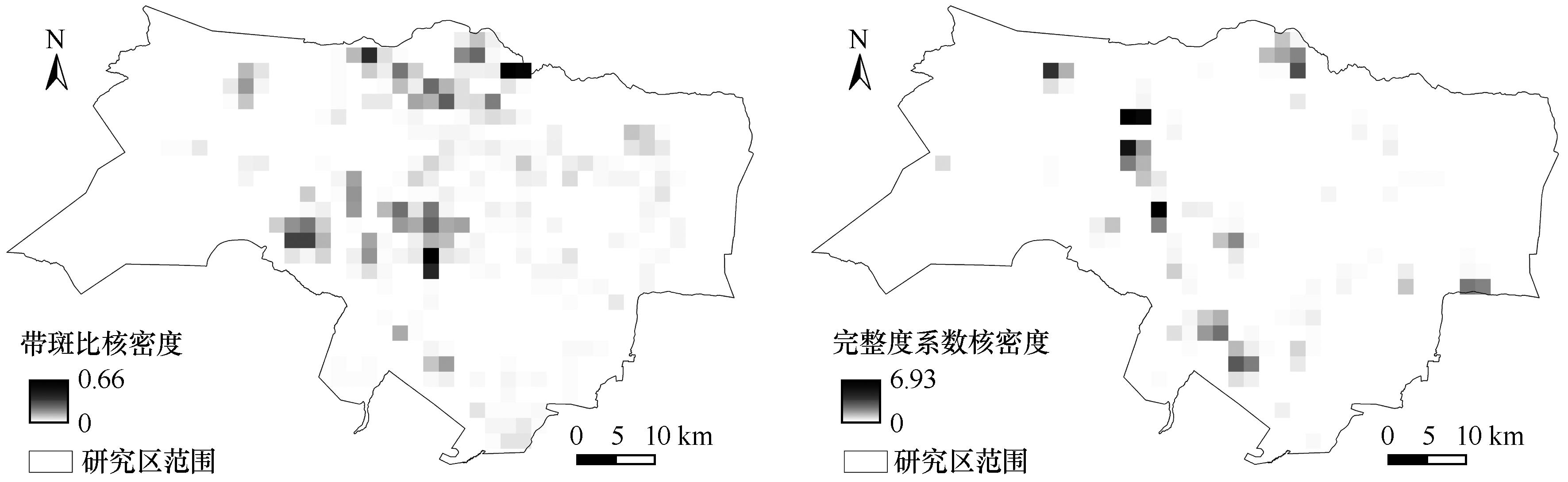
Fig.7 Nuclear density distribution of shelterbelts structure
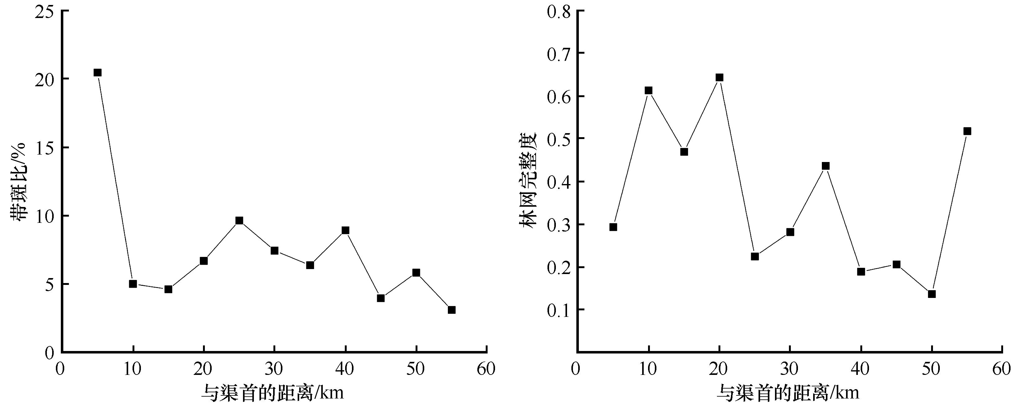
Fig.8 Correlation of shelterbelts structure and distance from the head of the canal
| 1 | Su Y, Zhao W, Su P,et al.Ecological effects of desertification control and desertified land reclamation in an oasis-desert ecotone in an arid region:a case study in Hexi Corridor,northwest China[J].Ecological Engineering,2007,29:117-124. |
| 2 | Zhao W, Hu G, Zhang Z.Shielding effect of oasis-protection systems composed of various forms of wind break on sand fixation in an arid region: a case study in the Hexi Corridor,northwest China[J].Ecological Engineering:The Journal of Ecotechnology,2008,33:119-125. |
| 3 | 何志斌,赵文智,屈连宝.黑河中游绿洲防护林的防护效应分析[J].生态学杂志,2005(1):79-82. |
| 4 | 刘钰华.新疆绿洲防护林体系[J].干旱区资源与环境,1995(4):187-192. |
| 5 | 刘康,陈一鹗.农田防护林效益及其对农作物产量的影响[J].水土保持通报,1993(5):39-43. |
| 6 | 刘康,朱玉伟,孙万忠,等.新疆杨农田防护林胁地影响的研究[J].新疆环境保护,1996(4):36-43. |
| 7 | 胡海波,张金池,王殿平,等.徐淮平原农田防护林带(网)对小麦产量的影响[J].南京林业大学学报,1997(4):3-7. |
| 8 | Caborn J M.The influence of shelter-belts on microclimate[J].Quarterly Journal of the Royal Meteorological Society,1955,81:112-115. |
| 9 | Thomas G, Josef E, Enno B,et al.Landscape structures (hedgerows) as adaptation measure to climate change in semi-arid regions[C]//Sustainable Development and Bioclimate:Reviewed Conference Proceedings,2009. |
| 10 | Nuberg I, Mylius S.Effect of shelter on the yield and water use of wheat[J].Australian Journal of Experimental Agriculture,2002,42(6):773-780. |
| 11 | 吴鹤吟,张淑艳.农田防护林防护效益研究综述[J].现代农业科技,2018(19):177-178. |
| 12 | Liu C, Zheng Z, Cheng H,et al.Airflow around single and multiple plants[J].Agricultural and Forest Meteorology,2018,252:27-38. |
| 13 | 周新华,孙中伟.试论林网在景观中布局的宏观度量与评价[J].生态学报,1994(1):24-31. |
| 14 | 范志平,关文彬,曾德慧,等.东北地区农田防护林高效多功能经营的指标体系及标准研究[J].应用生态学报,2001(5):701-705. |
| 15 | Deng R, Wang W, Li Y,et al.Analysis of changes in shelterbelt landscape in northeast China[J].Applied Ecology and Environmental Research,2019,15(5): 11655-11668. |
| 16 | Shi X, Li Y, Deng R.A method for spatial heterogeneity evaluation on landscape pattern of farmland shelter belt networks: a case study in midwest of Jilin Province,China[J].Chinese Geographical Science,2011,21(1):48-56. |
| 17 | Li X, Liu L, Xie J,et al.Optimizing the quantity and spatial patterns of farmland shelter forests increases cotton productivity in arid lands[J].Agriculture,Ecosystems and Environment,2020,292:106832. |
| 18 | 杨书雅,杨会巾,刘丽娟,等.玛纳斯河流域绿洲农田防护林景观格局评价[J].生态学杂志,2017(6):1690-1698. |
| 19 | Yang Z, Dong J, Qin Y,et al.Integrated analyses of PALSAR and Landsat imagery reveal more agroforests in a typical agricultural production region,North China Plain[J].Remote Sensing,2018,10(9):1323. |
| 20 | 朱教君.防护林学研究现状与展望[J].植物生态学报,2013,37(9):872-888. |
| 21 | Robert G.Trees as technology: planting shelterbelts on the Great Plains[J].History and Technology,2009,25:325-341. |
| 22 | Brandle J R, Hodges L, Zhou X H.Windbreaks in North American agricultural systems[J].Agroforestry Systems,2004,61:65-78. |
| 23 | Chendev Y G, Sauer T J, Gennadiev A N,et al.Accumulation of organic carbon in chernozems (Mollisols) under shelterbelts in Russia and the United States[J].Eurasian Soil Science,2015,48(1):43-53. |
| 24 | Torita H, Satou H.Relationship between shelterbelt structure and mean wind reduction[J].Agricultural and Forest Meteorology,2007,145(3/4):186-194. |
| 25 | Thevs N, Strenge E, Aliev K,et al.Tree shelterbelts as an element to improve water resource management in Central Asia[J].Water,2017,9(11):842. |
| 26 | Plate E J.Aerodynamics of shelter belts[J].Agricultural Meteorology,1971,8(3):203-222. |
| 27 | Cleugh H A.Effects of windbreak structure on wind flow[J].Agroforestry Systems,1998,41(1):55-84. |
| 28 | Kort J, Collins M, Ditsch D.A review of soil erosion potential associated with biomass crops[J].Biomass & Bioenergy,1998,14(4):351-359. |
| 29 | 封斌,高保山,麻保林,等.陕北榆林风沙区农田防护林结构配置与效益研究[J].西北林学院学报,2005(1):118-124. |
| 30 | 刘丽霞,王辉,孙栋元,等.绿洲农田防护林系统土壤蒸发特征研究[J].干旱区资源与环境,2008(1):162-166. |
| 31 | 孙旭,高岗,刘静,等.河套灌区两类农田防护林防护效益对比研究[J].林业资源管理,2009(4):85-91. |
| 32 | Mu S, Li B, Yao J,et al.Monitoring the spatio-temporal dynamics of the wetland vegetation in Poyang Lake by Landsat and MODIS observations[J].Science of The Total Environment,2020,725:138096. |
| 33 | Dronova I, Gong P, Wang L.Object-based analysis and change detection of major wetland cover types and their classification uncertainty during the low water period at Poyang Lake,China[J].Remote Sensing of Environment,2011,115:3220-3236. |
| 34 | Li J, Wang X, Bai L,et al.Quantification of lateral seepage from farmland during maize growing season in arid region[J].Agricultural Water Management,2017,191:85-97. |
| 35 | 姜凤岐,周新华,付梦华,等.林带疏透度模型及其应用[J].应用生态学报,1994(3):251-255. |
| 36 | 关文彬,李春平,李世锋,等.林带疏透度数字化测度方法的改进及其应用研究[J].应用生态学报,2002(6):651-657. |
| 37 | 朱金兆,贺康宁,魏天兴.农田防护林学[M].北京:中国林业出版社,2010:71-109. |
| 38 | 曹新孙,姜凤岐,雷启迪.自由林网对农田地形的影响[J].生态学报,1981(2):112-116. |
| 39 | 曹新孙,姜凤歧,朱廷耀.对“三北”农田防护林建设的几点意见[J].林业科技通讯,1980(3):16-19. |
| 40 | 沈言俐,杨诗秀,段新杰,等.防护林带的排水及耗水作用初步分析[J].灌溉排水,1999(2):38-40. |
| 41 | 朱教君,姜凤岐,范志平,等.林带空间配置与布局优化研究[J].应用生态学报,2003(8):1205-1212. |
| 42 | 李永平,冯永忠,杨改河.北方旱区农田防护林防风效应研究[J].西北农林科技大学学报(自然科学版),2009,37(6):92-98. |
| 43 | 葛玉祥,毕广有.平原地区杨树农田防护林生态功能评价[J].防护林科技,2018(5):41-42. |
| 44 | 常学向,赵文智.荒漠绿洲农田防护树种二白杨生长季节树干液流的变化[J].生态学报,2004(7):1436-1441. |
| 45 | 邓荣鑫,张树文,李颖.基于田间尺度的东北农田防护林防护效应分析[J].生态学杂志,2009(9):1756-1762. |
| 46 | 宗萍萍,鲍玉海,杨吉华,等.黄泛沙地小网格农田防护林网防护效应的研究[J].水土保持学报,2005(6):112-115. |
| [1] | Xinyang Li, Peiji Shi, Junfeng Yin, Yali Li, Wenshun Cai. Research on structural characteristics and optimization of tourism flow network in Hexi Corridor [J]. Journal of Desert Research, 2023, 43(4): 135-145. |
| [2] | Lingfei Zhong, Lihua Zhang. Changes in temperature and precipitation in the plain area of Hexi Corridor in 2000-2020 [J]. Journal of Desert Research, 2023, 43(2): 264-270. |
| [3] | Xuening Li, Xianying Xu, Xuemei Yang, Guiheng Zheng, Hujun Liu, Guiquan Fu, Fang Chen, Xiaoyun Bian. Health assessment of farmland shelter belt in Hexi Corridor based on DPSIR model [J]. Journal of Desert Research, 2023, 43(1): 234-243. |
| [4] | Xiaoyun Cheng, Qin Zhang, Fangfang Lan, Yuan Li, Yaxuan Han, Limin Zhang, Yanke Yang, Xinyuan Wang. Dynamic characteristics and driving factors of grassland desertification in Hexi Corridor [J]. Journal of Desert Research, 2022, 42(6): 134-141. |
| [5] | Mei Shao, Lipeng Ma, Xinyuan Wang, Xuehua Che, Fang Wang, Junfeng Lu, Wanyin Luo. The valuation of ecosystem service value of desertification grassland from 2004 to 2014 in Hexi Corridor, China [J]. Journal of Desert Research, 2022, 42(3): 63-73. |
| [6] | Lingge Wang, Rui Zhu, Zexia Chen, Zhenliang Yin, Rui Lu, Chunshuang Fang. Coupling effect of water-soil resources in Hexi Area of Gansu,China in 2000-2019 [J]. Journal of Desert Research, 2022, 42(2): 44-53. |
| [7] | Yanjun Guo, Linjuan Yang, Hong Chai, Yu Chen. Analysis of tourism competitiveness of five cities in Hexi Corridor based on factor analysis [J]. Journal of Desert Research, 2021, 41(5): 238-241. |
| [8] | Jiliang Liu, Wenzhi Zhao, Fengrui Li, Yibin Ba. Community dynamics of ground arachnid arthropods in a gravel gobi desert of the middle of the Hexi Corridor, China [J]. Journal of Desert Research, 2021, 41(3): 155-164. |
| [9] | Chuanhua Li, Huanhuan Yin, Tongbin Zhu, Min Zhou, Yutao Wang, Hao Sun, Hongjuan Cao, Haiyan Han. Impact of drought on net primary productivity of vegetation in arid and semi-arid areas: a case study of Hexi Corridor [J]. Journal of Desert Research, 2021, 41(1): 145-155. |
| [10] | Zhou Lifeng, Yang Rong, Zhao Wenzhi. Temporal evolution of soil water repellency in stabilized sand dunes in artificial sand fixation vegetation area on fringe of a desert [J]. Journal of Desert Research, 2020, 40(3): 185-192. |
| [11] | Li Yanying, Zhang Aiping, Li Hongying, Wang Fucun, Chen Ying, Zeng Ting. Relationship between Boundary Layer Height and Wind-sand Intensities over Hexi Corridor, China [J]. Journal of Desert Research, 2019, 39(5): 11-20. |
| [12] | Wang Xinyuan, Liu Shizeng, Chen Xiangshun, Wang Xiaojun, Wang Bin, Wan Xiang. Dynamic Changes and Driving Factors of Oasis in Hexi Corridor [J]. Journal of Desert Research, 2019, 39(4): 212-219. |
| [13] | Pan Kaijia, Zhang Zhengcai, Dong Zhibao, Zhang Caixia, Li Xingcai. Physicochemical Characteristics of Surface Sediments of Crescent-shaped Sand Dunes in the Hexi Corridor, Gansu, China [J]. Journal of Desert Research, 2019, 39(1): 44-51. |
| [14] | Zhang Jian, Chen Jia, Huang Xin, Wang Ziqiao. Spatio-temporal Evolution of Urban Economic Vulnerability and Influence Factors in the Hexi Corridor Region: Restriction of Water Resources [J]. Journal of Desert Research, 2019, 39(1): 203-211. |
| [15] | Li Danhua, Long Xiao, Wen Xiaopei, Jiang Yin, Meng Xiaowen. Influence of Underlying Surface on Dust Weatherin the Entrance of the Hexi Corridor [J]. JOURNAL OF DESERT RESEARCH, 2017, 37(6): 1210-1218. |
| Viewed | ||||||
|
Full text |
|
|||||
|
Abstract |
|
|||||
©2018Journal of Desert Research
Tel:0931-8267545
Email:caiedit@lzb.ac.cn;desert@lzb.ac.cn
Support:Magtech