
- CN 62-1070/P
- ISSN 1000-694X
- Bimonthly 1981
Journal of Desert Research ›› 2024, Vol. 44 ›› Issue (4): 46-56.DOI: 10.7522/j.issn.1000-694X.2024.00040
Previous Articles Next Articles
Eryan Liu1,2( ), Yuanyuan Zhao1,2,3(), Die Zhou1,2, Haiyan Wu1,2, Guanglei Gao1,2,3, Guodong Ding1,2,3
Received:2023-12-08
Revised:2024-03-10
Online:2024-07-20
Published:2024-08-29
Contact:
Yuanyuan Zhao
CLC Number:
Eryan Liu, Yuanyuan Zhao, Die Zhou, Haiyan Wu, Guanglei Gao, Guodong Ding. Spatiotemporal variation patterns of land desertification from 2000 to 2020 in the Horqin-Otindag Sandy Land[J]. Journal of Desert Research, 2024, 44(4): 46-56.
Add to citation manager EndNote|Ris|BibTeX
URL: http://www.desert.ac.cn/EN/10.7522/j.issn.1000-694X.2024.00040
| 沙化等级 | 植被覆盖度FVC/% | 地表景观 |
|---|---|---|
| 未沙化 | >60 | 草地、林地等,植被覆盖浓密 |
| 轻度沙化 | 30~60 | 固定沙地,表面有薄层黏土结皮、盐结皮,在风力作用下不发生位移 |
| 中度沙化 | 10~30 | 半固定沙地,流沙呈斑点状分布,有风沙活动现象但不严重 |
| 重度沙化 | <10 | 流动沙地,沙地表面植被稀疏,风沙流活动极其显著 |
Table 1 Classification of desertified land based on vegetation coverage
| 沙化等级 | 植被覆盖度FVC/% | 地表景观 |
|---|---|---|
| 未沙化 | >60 | 草地、林地等,植被覆盖浓密 |
| 轻度沙化 | 30~60 | 固定沙地,表面有薄层黏土结皮、盐结皮,在风力作用下不发生位移 |
| 中度沙化 | 10~30 | 半固定沙地,流沙呈斑点状分布,有风沙活动现象但不严重 |
| 重度沙化 | <10 | 流动沙地,沙地表面植被稀疏,风沙流活动极其显著 |
| 趋势等级 | ||
|---|---|---|
| 沙化明显逆转 | >1.96 | |
| 沙化轻微逆转 | ||
| 基本稳定 | — | |
| 沙化轻微加剧 | ||
| 沙化明显加剧 |
Table 2 Classification of land desertification trend
| 趋势等级 | ||
|---|---|---|
| 沙化明显逆转 | >1.96 | |
| 沙化轻微逆转 | ||
| 基本稳定 | — | |
| 沙化轻微加剧 | ||
| 沙化明显加剧 |
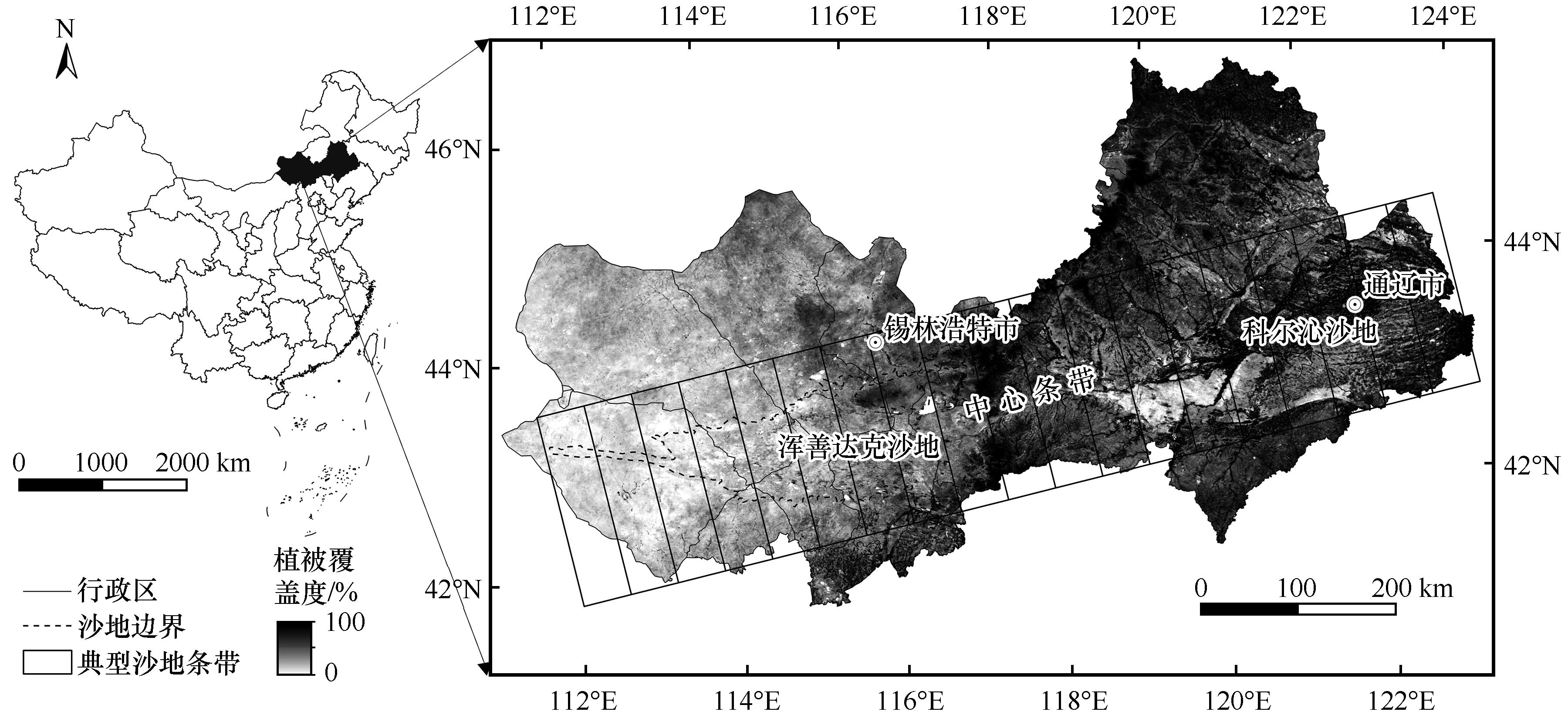
Fig.1 The location of the study area
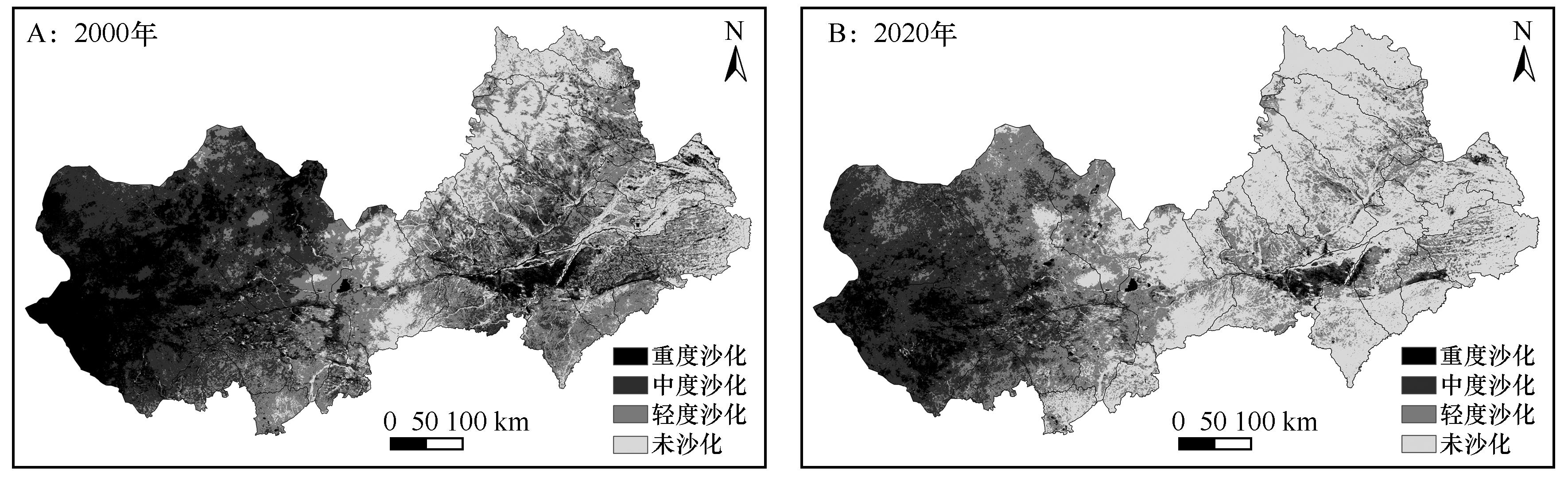
Fig.2 Spatial distribution of land desertification in the study area
| 沙化等级 | 2000年 | 2020年 | ||
|---|---|---|---|---|
| 面积/万km2 | 比例/% | 面积/万km2 | 比例/% | |
| 重度沙化 | 5.33 | 18.98 | 1.78 | 6.33 |
| 中度沙化 | 8.05 | 28.64 | 6.01 | 21.38 |
| 轻度沙化 | 9.06 | 32.24 | 8.25 | 29.37 |
| 未沙化 | 5.66 | 20.14 | 12.05 | 42.92 |
Table 3 Area and proportion of land desertification grade in the study area
| 沙化等级 | 2000年 | 2020年 | ||
|---|---|---|---|---|
| 面积/万km2 | 比例/% | 面积/万km2 | 比例/% | |
| 重度沙化 | 5.33 | 18.98 | 1.78 | 6.33 |
| 中度沙化 | 8.05 | 28.64 | 6.01 | 21.38 |
| 轻度沙化 | 9.06 | 32.24 | 8.25 | 29.37 |
| 未沙化 | 5.66 | 20.14 | 12.05 | 42.92 |
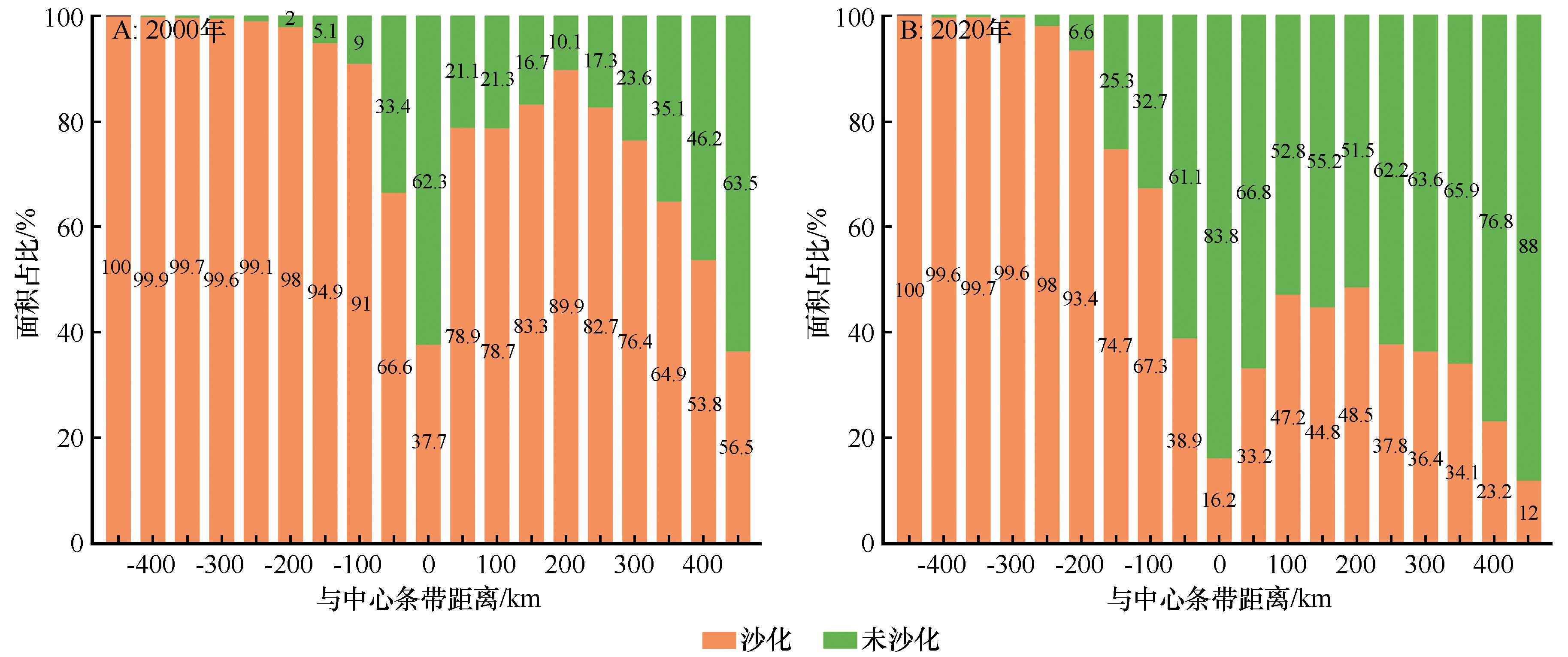
Fig.3 The proportion of desertification grade area in typical sandy stripe
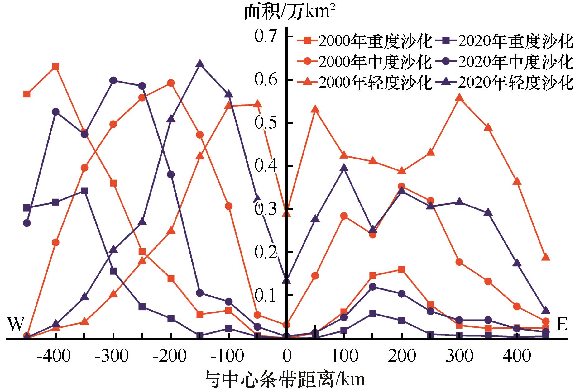
Fig.4 Severe, moderate, and mild desertification areas in typical sandy stripe
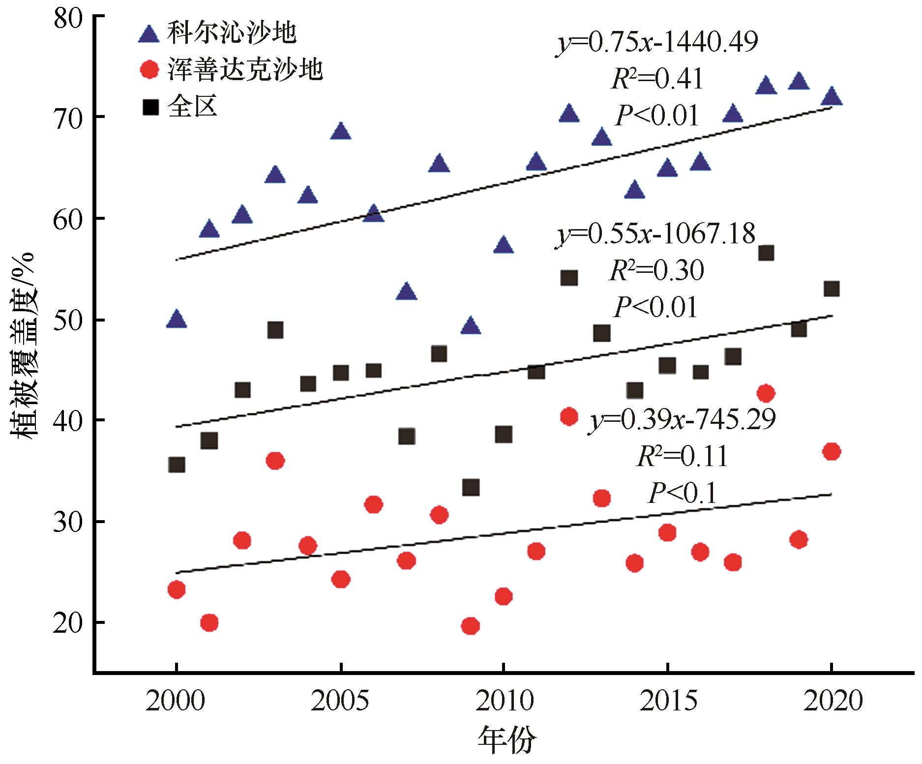
Fig.5 The change trend of vegetation coverage of the study area from 2000 to 2020
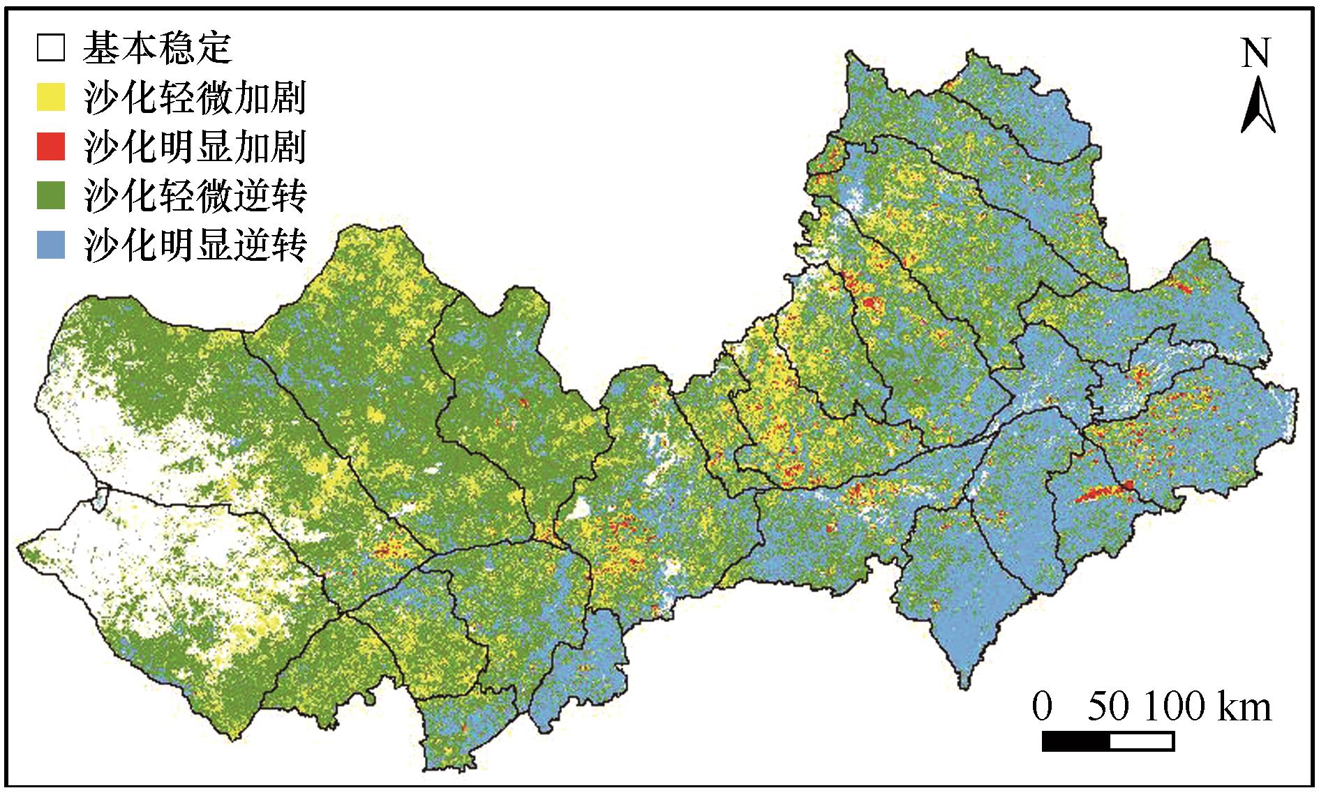
Fig.6 The trend of land desertification in the study area from 2000 to 2020

Fig.7 Interannual variation of vegetation coverage in different units of typical sandy strip
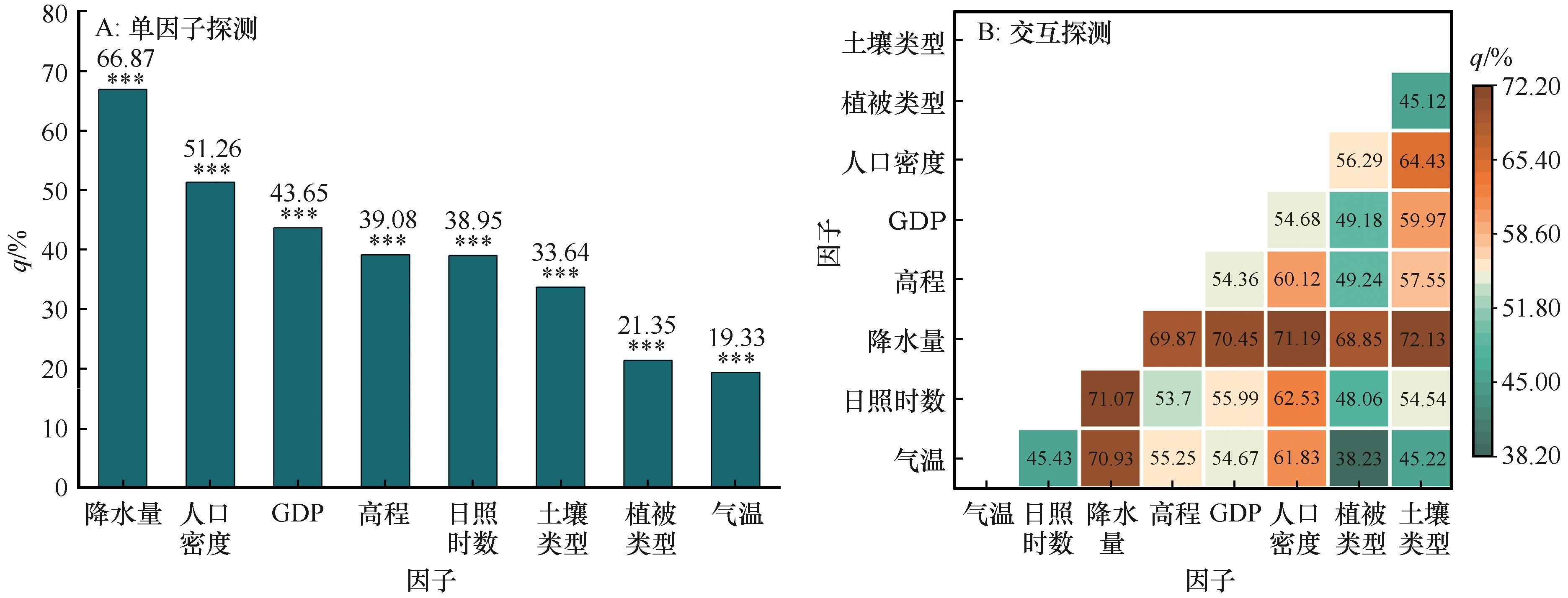
Fig.8 The explanatory power of different driving factors on land desertification in the research area from 2000 to 2020
| 1 | Chen T, Bao A, Jiapaer G,et al.Disentangling the relative impacts of climate change and human activities on arid and semiarid grasslands in Central Asia during 1982-2015[J].Science of the Total Environment,2019,653:1311-1325. |
| 2 | Ren Y, Zhang B, Chen X,et al.Analysis of spatial-temporal patterns and driving mechanisms of land desertification in China[J].Science of the Total Environment,2024,909:168429. |
| 3 | 杨小平,梁鹏,张德国,等.中国东部沙漠/沙地全新世地层序列及其古环境[J].中国科学:地球科学,2019,49(8):1293-1307. |
| 4 | 吴见.土地沙化信息遥感监测技术研究进展[J].世界林业研究,2014,27(1):57-61. |
| 5 | 赵安周,刘宪锋,朱秀芳,等.2000~2014年黄土高原植被覆盖时空变化特征及其归因[J].中国环境科学,2016,36(5):1568-1578. |
| 6 | 沈贝贝,魏一博,马磊超,等.内蒙古草原植被覆盖度时空格局变化及驱动因素分析[J].农业工程学报,2022,38(12):118-126. |
| 7 | 朱玉霞,覃志豪,徐斌.基于MODIS数据的草原荒漠化年际动态变化研究:以内蒙古自治区为例[J].中国草地学报,2007(4):2-8. |
| 8 | 同丽嘎,宁小莉,张靖,等.近30 a浑善达克沙地沙漠化时空演变特征及驱动机制研究[J].干旱区地理,2021,44(4):992-1002. |
| 9 | 陈少丹,张利平,汤柔馨,等.基于SPEI和TVDI的河南省干旱时空变化分析[J].农业工程学报,2017,33(24):126-132. |
| 10 | 程小强,周兆叶,李旺平,等.基于MODIS数据的中亚地区旱情监测及影响因素分析[J].农业工程学报,2022,38(10):128-137. |
| 11 | 王永芳,张继权,马齐云,等.21世纪初科尔沁沙地沙漠化对区域气候变化的响应[J].农业工程学报,2016,32():177-185. |
| 12 | Duo A, Zhao W J, Qu X Y,et al.Spatio-temporal variation of vegetation coverage and its response to climate change in North China plain in the last 33 years[J].International Journal of Applied Earth Observation and Geoinformation,2016,53:103-117. |
| 13 | 王晓峰,张明明,尹礼唱,等.2000-2015年中国干旱半干旱地区沙漠化进程驱动力研究[J].生态环境学报,2019,28(5):948-957. |
| 14 | 段翰晨,王涛,薛娴,等.科尔沁沙地沙漠化时空演变及其景观格局:以内蒙古自治区奈曼旗为例[J].地理学报,2012,67(7):917-928. |
| 15 | 卜凡蕊,刘颖,邹学勇.中国东部典型沙地植被覆盖度对降水变化的响应[J].中国沙漠,2023,43(3):9-20. |
| 16 | 邓腾林,宋一凡,王明新,等.浑善达克沙地归一化植被指数动态变化及其对标准化降水蒸散发指数的时空响应关系[J].中国水利水电科学研究院学报,2022,20(3):221-230. |
| 17 | 赵媛媛,武海岩,丁国栋,等.浑善达克沙地土地沙漠化研究进展[J].中国沙漠,2020,40(5):101-111. |
| 18 | 徐新良.中国GDP空间分布公里网格数据集[DS].资源环境科学数据注册与出版系统.http://www.resdc.cn/doi,2017,doi:10.12078/2017121102 . |
| 19 | 徐新良.中国人口空间分布公里网格数据集[DS].资源环境科学数据注册与出版系统.http://www.resdc.cn/ doi,2017,doi:10.12078/2017121101 . |
| 20 | Zhang Z X, Chang J, Xu C Y,et al.The response of lake area and vegetation cover variations to climate change over the Qinghai-Tibetan Plateau during the past 30 years[J].Science of the Total Environment,2018,635:443-451. |
| 21 | Leprieur C, Verstraete M M, Pinty B.Evaluation of the performance of various vegetation indices to retrieve vegetation cover from AVHRR data[J].Remote Sensing Reviews,1994,10(4):265-284. |
| 22 | 刘俊壕,周海盛,郭群.中国北方干旱半干旱区沙漠化治理对植被格局的影响[J].中国沙漠,2023,43(5):204-213. |
| 23 | 李苗苗,吴炳方,颜长珍,等.密云水库上游植被覆盖度的遥感估算[J].资源科学,2004(4):153-159. |
| 24 | 杨婷婷,吴新宏,李鹏,等.基于TM 影像的镶黄旗北部沙地沙漠化动态监测[J].西北林学院学报,2009,24(2):145-147. |
| 25 | 王涛,吴薇,王熙章.沙质荒漠化的遥感监测与评估:以中国北方沙质荒漠化区内的实践为例[J].第四纪研究,1998,18(2):108-118. |
| 26 | 孙锐,陈少辉,苏红波.黄土高原不同生态类型NDVI时空变化及其对气候变化响应[J].地理研究,2020,39(5):1200-1214. |
| 27 | Yin S, Guo M, Wang X F,et al.Spatiotemporal variation and distribution characteristics of crop residue burning in China from 2001 to 2018[J].Environmental Pollution,2021,268:115849. |
| 28 | 王劲峰,徐成东.地理探测器:原理与展望[J].地理学报,2017,72(1):116-134. |
| 29 | Song Y, Wang J, Ge Y,et al.An optimal parameters-based geographical detector model enhances geographic characteristics of explanatory variables for spatial heterogeneity analysis:cases with different types of spatial data[J].GIScience & Remote Sensing,2020,57(5):593-610. |
| 30 | 王旭洋,李玉霖,连杰,等.半干旱典型风沙区植被覆盖度演变与气候变化的关系及其对生态建设的意义[J].中国沙漠,2021,41(1):183-194. |
| 31 | 唐毅,蒋德明,陈雪峰,等.疏林草原榆树天然更新研究进展[J].中国沙漠,2011,31(5):1226-1230. |
| 32 | 岳喜元,左小安,赵学勇,等.科尔沁沙地沙漠化风险评价[J].中国沙漠,2018,38(1):8-16. |
| 33 | 段翰晨,王涛,薛娴,等.基于RS与GIS的科尔沁沙地沙漠化时空演变[J].中国沙漠,2013,33(2):470-477. |
| 34 | Huang L, Xiao T, Zhao Z P,et al.Effects of grassland restoration programs on ecosystems in arid and semiarid China[J].Journal of Environmental Management,2013,117:268-275. |
| 35 | 王涛,吴薇,赵哈林,等.科尔沁地区现代沙漠化过程的驱动因素分析[J].中国沙漠,2004,24(5):3-12. |
| 36 | 吕基新,赖勇,耿守保,等.1992-2018年内蒙古自治区植被动态演替特征及驱动力[J].应用生态学报,2022,33(5):1240-1250. |
| 37 | 石淞,李文,曲琛,等.大兴安岭林草交错带植被NDVI时空演变及定量归因[J].环境科学,2024,45(1):248-261. |
| 38 | 洪光宇,王晓江,苏庆溥,等.毛乌素沙地流动沙丘土壤水分模拟及渗漏特征[J].中国沙漠,2023,43(2):288-298. |
| 39 | Qu Y B, Zhao Y Y, Ding G D,et al.Spatiotemporal patterns of the forage-livestock balance in the Xilin Gol steppe,China:implications for sustainably utilizing grassland-ecosystem services[J].Journal of Arid Land,2021,13(2):135-151. |
| 40 | 潘昌祥,欧阳茜如,廖梦榆,等.西北干旱区沙漠化土地生态修复技术及沙产业的适用范围[J].中国沙漠,2023,43(5):155-165. |
| [1] | Yu Ren, Bo Zhang, Xidong Chen. Desertification sensitivity assessment in Horqin Sandy Land [J]. Journal of Desert Research, 2023, 43(2): 159-169. |
| [2] | Xiaoyun Cheng, Qin Zhang, Fangfang Lan, Yuan Li, Yaxuan Han, Limin Zhang, Yanke Yang, Xinyuan Wang. Dynamic characteristics and driving factors of grassland desertification in Hexi Corridor [J]. Journal of Desert Research, 2022, 42(6): 134-141. |
| [3] | Xuyang Wang, Yulin Li, Jie Lian, Yulong Duan, Lilong Wang. Relationship between vegetation coverage and climate change in semi-arid sandy land and the significance to ecological construction [J]. Journal of Desert Research, 2021, 41(1): 183-194. |
| [4] | Zhang Weijun, Nie Qinghua, He Xingdong. Changes of soil nutrients with five years of the Ningxia Habahu National Nature Reserve [J]. Journal of Desert Research, 2020, 40(3): 27-32. |
| [5] | Chang Xueli, Li Xiumei, Bai Xuelian, Ji Shuxin, Wang Lixiang. Assessment of Oasis Expanding and Hydrological Process in Oasis-desert Ecotone [J]. Journal of Desert Research, 2019, 39(4): 204-211. |
| [6] | Cheng Long, Jia Xiaohong, Wu Bo, Li Yuanshou, Zhao Xuebin, Zhou Hong. Relationship between the Condensation Process of Hygroscopic and Condensate Water and the Air & Soil Humiture in Alpine Sandy Lands [J]. Journal of Desert Research, 2019, 39(3): 77-86. |
| [7] | Zhang Jiaqi, Zhang Bo, Ma Bin, Cao Bo, Liang Jingjing, Ma Shangqian. Spatial-temporal Variation of NDVI in Sanjiang Plain and Its Response to Climate Change [J]. Journal of Desert Research, 2019, 39(3): 206-213. |
| [8] | Huang Yuan, Yue Depeng, Yu Qiang, Zhang Qibin, Ma Huan. Spatiotemporal Variability and Interaction of Surface Water and Groundwater in Dengkou County [J]. Journal of Desert Research, 2019, 39(1): 161-170. |
| [9] | Guo Zichen, Liu Shulin, Kang Wenping, Chen Xiang, Zhang Xueqin. Change Trend of Vegetation Coverage in the Mu Us Sandy Region from 2000 to 2015 [J]. Journal of Desert Research, 2018, 38(5): 1099-1107. |
| [10] | Wu Xin, Xu Kai, Zhang Jiyin, Li Jiangfeng. Sand Source of Grassland Desertification and Its Geological Origin in Xilin Gol Steppe of China [J]. JOURNAL OF DESERT RESEARCH, 2018, 38(1): 92-100. |
| [11] | Zhang Liqiu, Zhang Hong, Li Jiao, Li Jinchang. Climate Change in Sandy Desertification Area of the Northern Shanxi from 1980 to 2014 [J]. JOURNAL OF DESERT RESEARCH, 2016, 36(4): 1116-1125. |
| [12] | Xu Ligang, Zhou Hongfei, Du Li, Bao Ziyun. Spatio-temporal Change and Trend of Precipitation in Northwest China During 1951-2008 [J]. JOURNAL OF DESERT RESEARCH, 2015, 35(3): 724-734. |
| [13] | Zhao Chao, Lu Ruijie, Li Jinfeng. Land Desertification and Grain Size Characteristics of Landsurface Deposits in the Qinghai Lake Watershed [J]. JOURNAL OF DESERT RESEARCH, 2015, 35(2): 276-283. |
| [14] | Li Xiaoying, Yao Zhengyi, Wang Hongwei, Xiao Jianhua. The Driving Mechanism of Sandy Desertification in the Zoige Basin of China [J]. JOURNAL OF DESERT RESEARCH, 2015, 35(1): 51-59. |
| [15] | Li Yanping, Chen Changchun, Zhang Yuqing, Bi Shuoben. The Characteristics of Drought Disasters in Beijing during the Ming Dynasty (1368-1644) Based on Ensemble Empirical Mode Decomposition Method [J]. JOURNAL OF DESERT RESEARCH, 2014, 34(3): 835-840. |
| Viewed | ||||||
|
Full text |
|
|||||
|
Abstract |
|
|||||
©2018Journal of Desert Research
Tel:0931-8267545
Email:caiedit@lzb.ac.cn;desert@lzb.ac.cn
Support:Magtech