
- CN 62-1070/P
- ISSN 1000-694X
- Bimonthly 1981
Journal of Desert Research ›› 2026, Vol. 46 ›› Issue (2): 201-210.DOI: 10.7522/j.issn.1000-694X.2025.00185
Huishi Du1( ), Xingyao Wu1, Hasi Eerdun2
Received:2025-10-09
Revised:2025-11-07
Online:2026-03-20
Published:2026-04-13
CLC Number:
Huishi Du, Xingyao Wu, Hasi Eerdun. Characteristics of landscape evolution in China's desert regions in 1980-2024[J]. Journal of Desert Research, 2026, 46(2): 201-210.
Add to citation manager EndNote|Ris|BibTeX
URL: http://www.desert.ac.cn/EN/10.7522/j.issn.1000-694X.2025.00185
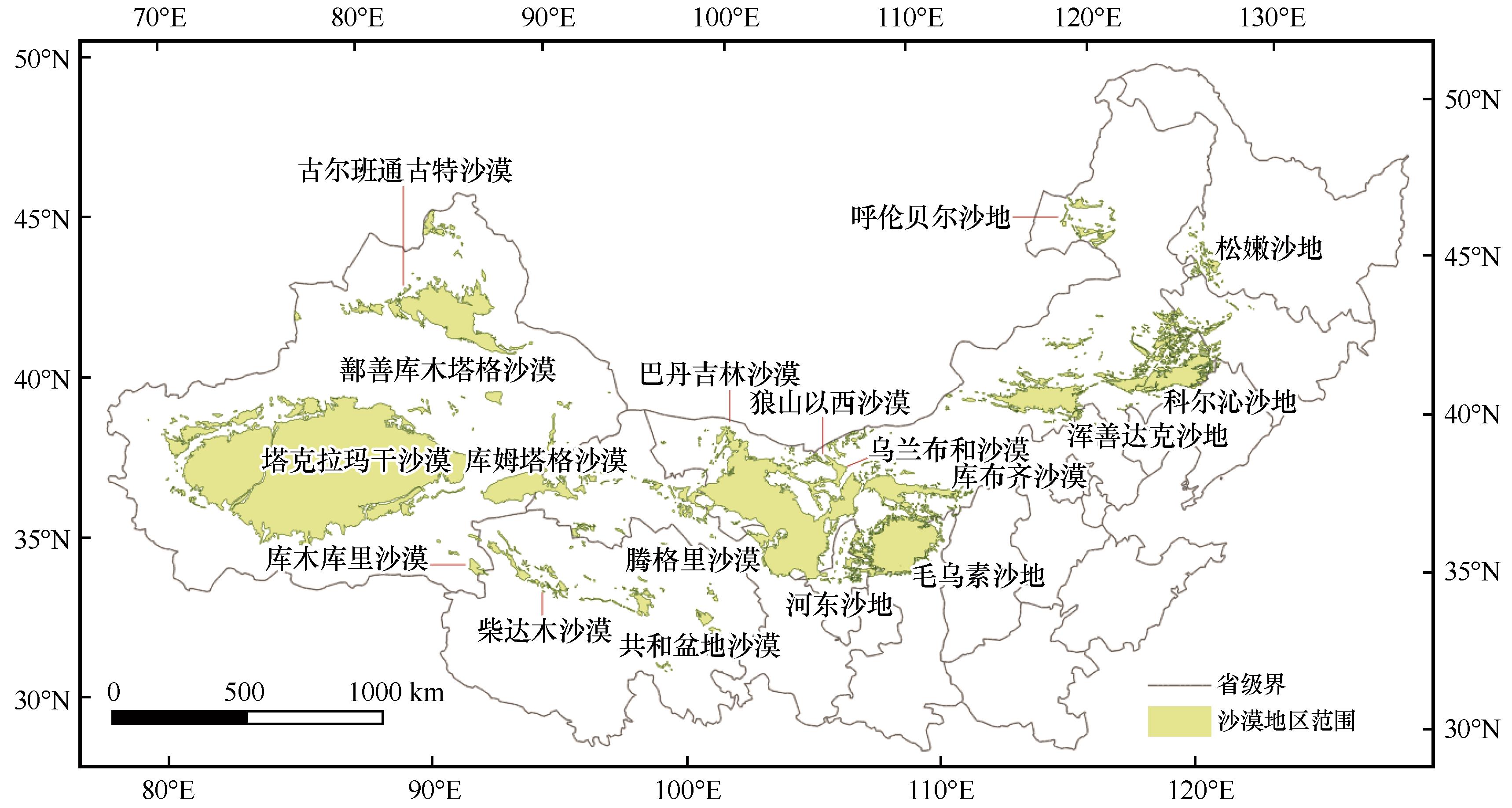
Fig.1 Study area of deserts in Northern China
| 尺度 | 名称 | 符号 | 意义 | 单位(范围) |
|---|---|---|---|---|
| 类别水平 | 斑块类型面积 | CA | 某类景观斑块的总面积,是分析其规模变化的基础 | hm2 |
| 景观百分比 | PLAND | 某类斑块面积占景观总面积的比例,直接反映其相对重要性 | % (0~100) | |
| 最大斑块指数 | LPI | 某类斑块中最大斑块所占的面积百分比,衡量其优势度和控制力 | % (0~100) | |
| 斑块数量 | NP | 某类斑块的斑块总数量,是表征景观破碎化最直接的指标 | (≥1) | |
| 景观形状指数 | LSI | 衡量某类斑块整体边界的复杂程度。值越大,形状越不规则 | (≥1) | |
| 面积加权平均分形维数 | FRAC_AM | 衡量某类斑块形状的几何复杂性,并经过面积加权,更能反映主体部分的特征。值越接近1,形状越简单;越接近2,形状越复杂 | (1~2) | |
| 平均最邻近距离 | ENN_MN | 同类斑块间的平均最短距离,反映该类型在空间上的隔离或聚集程度。值越大,分布越分散 | m | |
| 斑块结合度指数 | COHESION | 衡量同类斑块之间的物理连接性。值越高,表明斑块连接成片的程度越好,功能连通性越强 | %(0~100) | |
| 景观水平 | 蔓延度指数 | CONTAG | 描述景观中不同斑块类型的聚集和延展程度。高值表明景观由少数连通的大斑块主导;低值表明景观破碎,由多种小斑块镶嵌构成 | % (0~100) |
| 聚集度指数 | AI | 衡量景观中所有斑块类型的总体聚集程度。高值表明同类斑块高度聚集 | % (0~100) | |
| 香农多样性指数 | SHDI | 反映景观格局的丰富度和均匀度综合特征。值越大,表明斑块类型越多或各类型面积分布越均匀 | (≥0) | |
| 香农均匀度指数 | SHEI | 反映景观中各斑块类型面积分布的均匀程度。值越接近1,分布越均匀 | (0~1) |
Table 1 Landscape pattern indices[37]
| 尺度 | 名称 | 符号 | 意义 | 单位(范围) |
|---|---|---|---|---|
| 类别水平 | 斑块类型面积 | CA | 某类景观斑块的总面积,是分析其规模变化的基础 | hm2 |
| 景观百分比 | PLAND | 某类斑块面积占景观总面积的比例,直接反映其相对重要性 | % (0~100) | |
| 最大斑块指数 | LPI | 某类斑块中最大斑块所占的面积百分比,衡量其优势度和控制力 | % (0~100) | |
| 斑块数量 | NP | 某类斑块的斑块总数量,是表征景观破碎化最直接的指标 | (≥1) | |
| 景观形状指数 | LSI | 衡量某类斑块整体边界的复杂程度。值越大,形状越不规则 | (≥1) | |
| 面积加权平均分形维数 | FRAC_AM | 衡量某类斑块形状的几何复杂性,并经过面积加权,更能反映主体部分的特征。值越接近1,形状越简单;越接近2,形状越复杂 | (1~2) | |
| 平均最邻近距离 | ENN_MN | 同类斑块间的平均最短距离,反映该类型在空间上的隔离或聚集程度。值越大,分布越分散 | m | |
| 斑块结合度指数 | COHESION | 衡量同类斑块之间的物理连接性。值越高,表明斑块连接成片的程度越好,功能连通性越强 | %(0~100) | |
| 景观水平 | 蔓延度指数 | CONTAG | 描述景观中不同斑块类型的聚集和延展程度。高值表明景观由少数连通的大斑块主导;低值表明景观破碎,由多种小斑块镶嵌构成 | % (0~100) |
| 聚集度指数 | AI | 衡量景观中所有斑块类型的总体聚集程度。高值表明同类斑块高度聚集 | % (0~100) | |
| 香农多样性指数 | SHDI | 反映景观格局的丰富度和均匀度综合特征。值越大,表明斑块类型越多或各类型面积分布越均匀 | (≥0) | |
| 香农均匀度指数 | SHEI | 反映景观中各斑块类型面积分布的均匀程度。值越接近1,分布越均匀 | (0~1) |
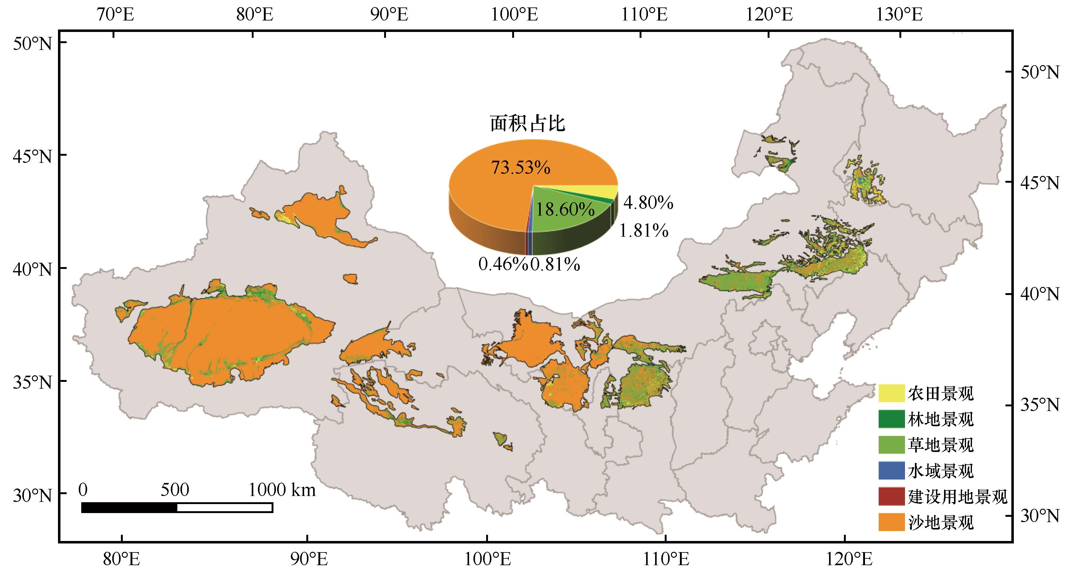
Fig.2 Current landscape pattern of the study area
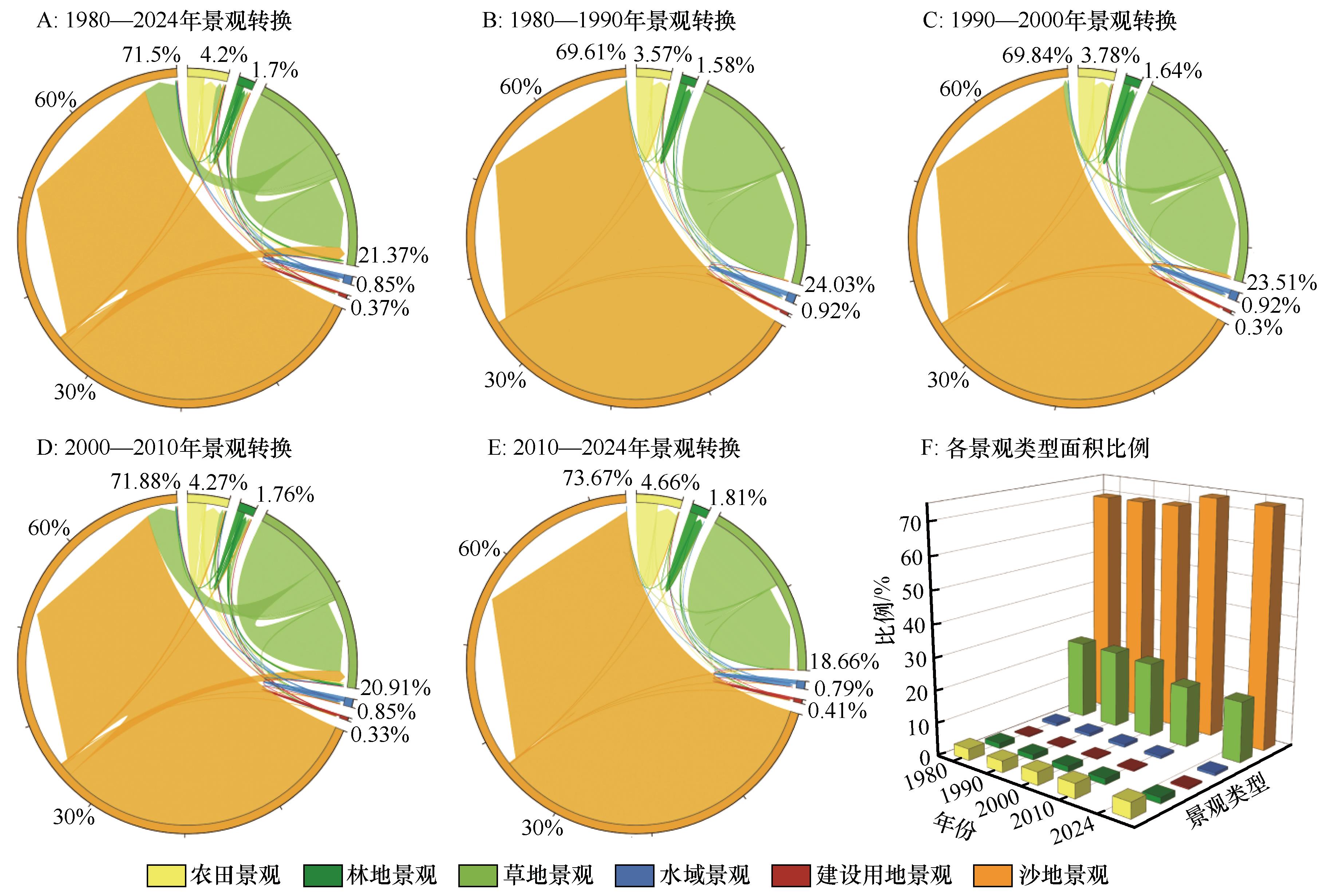
Fig.3 Temporal transformation of landscape types and area proportion in the desert regions
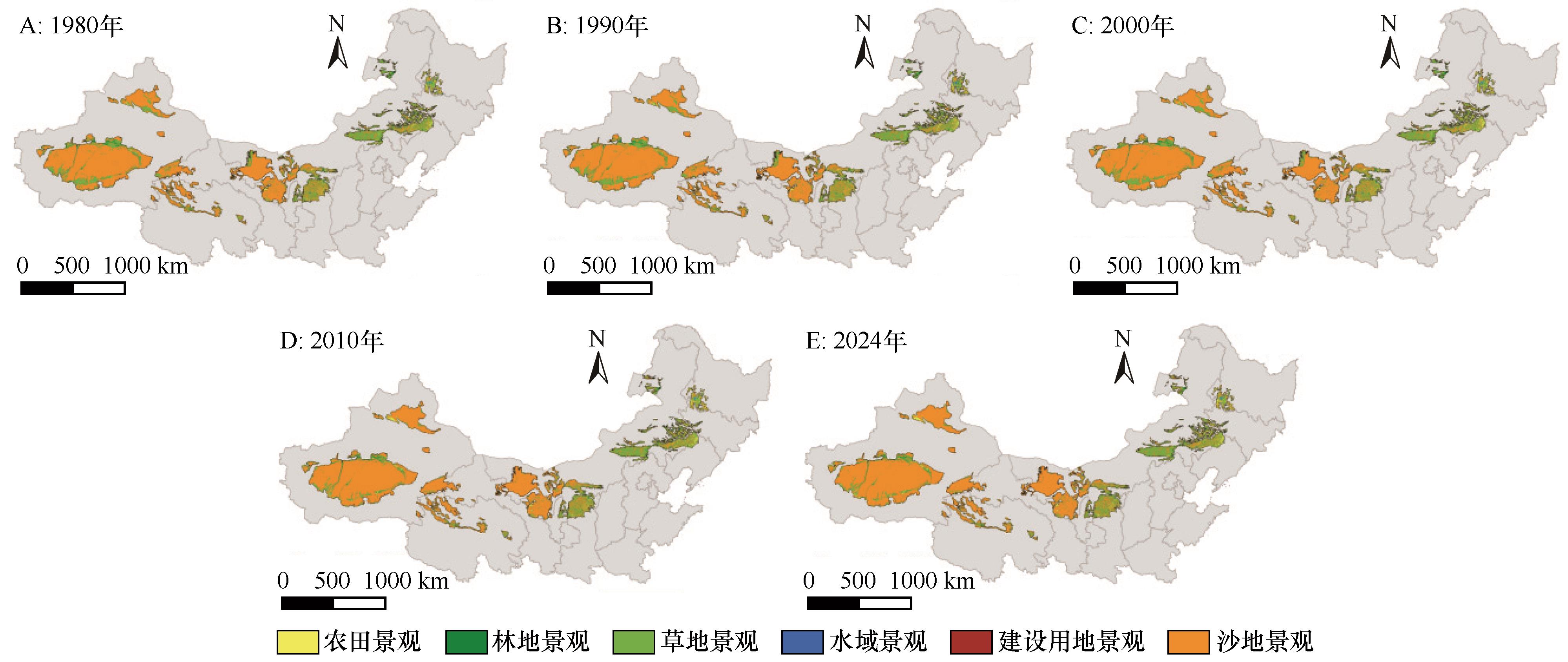
Fig.4 Spatial evolution of desert landscapes
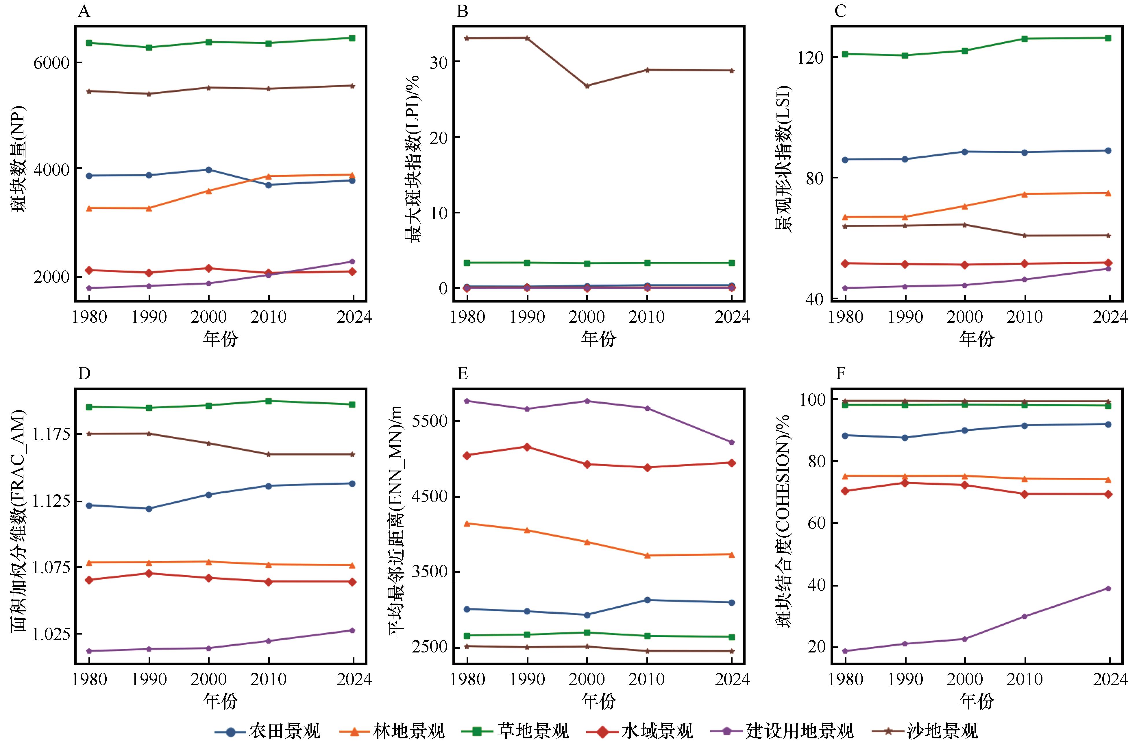
Fig.5 Changes in landscape pattern indices at the class level
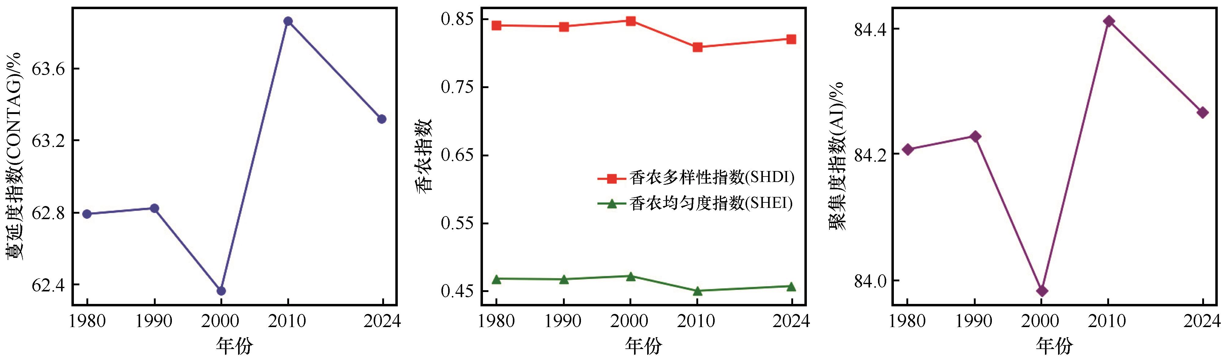
Fig.6 Changes in landscape pattern indices at the landscape level
| [1] | 王涛.中国沙漠与沙漠化[M].石家庄:河北科学技术出版社,2003. |
| [2] | 易小雅,张德全,刘勇,等.2000-2020年内蒙古杭锦旗植被变化特征及其对气候要素的响应[J].中国沙漠,2024,44(3):51-62. |
| [3] | Wang J, Wang Y, Xu D.Desertification in northern China from 2000 to 2020:the spatial-temporal processes and driving mechanisms[J].Ecological Informatics,2024,82(4):102769. |
| [4] | Chi W, Zha Y, Kuang W,et al.Impacts of anthropogenic land use/cover changes on soil wind erosion in China[J].Science of The Total Environment,2019,668:204-215. |
| [5] | Turner M G.Landscape ecology:what is the state of the science?[J].Annual Review of Ecology,Evolution,and Systematics,2005,36:319-344. |
| [6] | Wang M, Dong Z, Luo W,et al.Spatial variability of vegetation characteristics,soil properties and their relationships in and around China's Badain Jaran Desert[J].Environmental Earth Sciences,2015,74(14):6847-6858. |
| [7] | 曾佳,郭峰,赵灿,等.塔克拉玛干沙漠南缘小绿洲近50a来气候变化特征[J].干旱区地理,2014,37(5):948-957. |
| [8] | Tal A.Rethinking the sustainability of Israel's irrigation practices in the drylands[J].Water Research,2016,90:387-394. |
| [9] | 沈伟俊,吴建国,林勇彪,等.粒度变化对景观格局分析的影响[J].生态学报,2012,23(12):2506-2519. |
| [10] | Xing Y X, Chen Y, Yan S R,et al.Dust storms from the Taklamakan Desert significantly darken snow surface on surrounding mountains[J].Atmospheric Chemistry and Physics,2024,24(9):5199-5219. |
| [11] | Uuemaa E, Antrop M, Roosaare J,et al.Landscape metrics and indices:an overview of their use in landscape research[J].Living Reviews in Landscape Research,2009,3(1):1-28. |
| [12] | Song X P.Global land change from 1982 to 2016[J].Nature,2019,560(7720):639-643. |
| [13] | Frazier A E.Landscape metrics:past progress and future directions[J].Current Landscape Ecology Reports,2019,4(2):23-29. |
| [14] | Herrmann S M, Hutchinson C F.The changing contexts of the desertification debate[J].Journal of Arid Environments,2005,63(3):538-555. |
| [15] | Karnieli A, Gilad U, Ponzet M,et al.Assessing land-cover change and degradation in the Central Asian deserts using satellite image processing and ground-based measurements[J].Journal of Arid Environments,2008,72(11):2093-2105. |
| [16] | Reynolds J F, Smith D M S, Lambin E F,et al.Global desertification:building a science for dryland development[J].Science,2007,316(5826):847-851. |
| [17] | Du H S, Eerdun Hasi.Sandy land-lake-vegetation landscape of Songnen Sandy Land of China:pattern,process and mechanism[J].Chinese Geographical Science,2022,32(4):580-591. |
| [18] | Cao S, Chen L, Shankman D,et al.Excessive reliance on afforestation in China's arid and semi-arid regions: lessons in ecological restoration[J].Earth-Science Reviews,2011,104(4):240-245. |
| [19] | 郝新忠,石长春,高振梁,等.气象因子变化特征对典型地区荒漠化的影响研究[J].西北林学院学报,2023,38(6):196-202. |
| [20] | 刘二燕,赵媛媛,周蝶,等.科尔沁-浑善达克沙地2000-2020年土地沙化时空变化格局[J].中国沙漠,2024,44(4):46-56. |
| [21] | 段翰晨,薛娴.基于DEM的科尔沁沙地沙漠化土地时空分布特征[J].干旱区资源与环境,2018,32(8):74-79. |
| [22] | 金莉莉,李振杰,何清,等.塔克拉玛干沙漠腹地人工绿地中心区域与边缘地带小气候[J].中国沙漠,2017,37(5):986-996. |
| [23] | Sun F, Wang Y, Chen Y,et al.Historic and simulated desert-oasis ecotone changes in the arid Tarim River Basin,China[J].Remote Sensing,2021,13(4):647. |
| [24] | 蒋超亮,吴玲,安静.1998-2016年古尔班通古特沙漠南缘景观格局变化及驱动力[J].生态学杂志,2018,37(12):3729-3735. |
| [25] | 赵鸿雁,颜长珍,李森,等.黄河流域2000-2020年土地沙漠化遥感监测及驱动力分析[J].中国沙漠,2023,43(3):127-137. |
| [26] | Liu J, Li S, Ouyang Z,et al.Ecological and socioeconomic effects of China's policies for ecosystem services[J].Proceedings of the National Academy of Sciences,2008,105(28):9477-9482. |
| [27] | 张茜,於冉,储昭君,等.2000-2020年安徽省生境质量时空演变及其影响因素[J].水土保持通报,2024,44(2):416-425. |
| [28] | Bryan B A, Gao L, Ye Y,et al.China's response to a national land-system sustainability emergency[J].Nature,2018,559(7713):193-204. |
| [29] | 刘俊壕,周海盛,郭群.中国北方干旱半干旱区沙漠化治理对植被格局的影响[J].中国沙漠,2023,43(5):204-213. |
| [30] | 杜会石,哈斯额尔敦,王宗明.科尔沁沙地范围确定及风沙地貌特征研究[J].北京师范大学学报(自然科学版),2017,53(1):33-37. |
| [31] | 申元村,王秀红,丛日春,等.中国沙漠、戈壁生态地理区划研究[J].干旱区资源与环境,2013,27(1):1-13. |
| [32] | 郭福生,彭花明,陈建平,等.沙漠环境的时空演化及其成因的探讨[J].世界地质,2003,22(2):152-156. |
| [33] | 董治宝,吕萍.70年来中国风沙地貌学的发展[J].地理学报,2020,75(3):509-528. |
| [34] | 吴正.风沙地貌学[M].北京:科学出版社,1987. |
| [35] | 中华人民共和国地貌集编辑委员会.中华人民共和国地貌图集(1∶1000000)[M].北京:科学出版社,2009. |
| [36] | Wei C, Dong X, Ma Y,et al.Uncertainty analysis on the effects of landscape pattern on runoff and sediment using multi-source land use data:a case study in the Hushan River Basin of the Poyang Lake Regions[J].Acta Ecologica Sinica,2025,45(3):1102-1115. |
| [37] | Mcgarigal K, Marks B J.Fragstats 4.2 Help documentation[EB/OL].(2021-10-28) [2025-10-02].. |
| [38] | 郑天桥,张惜伟.近20a乌兰布和沙漠土地利用/覆盖时空变化特征分析与预测[J].内蒙古林业科技,2022,48(4):28-35. |
| [39] | Ouyang Z, Zheng H, Xiao Y,et al.A policy-driven large-scale ecological restoration:quantifying ecosystem services and values of the Grain for Green Programme in China[J].Science,2016,354(6311):441-445. |
| [40] | Cao S.Dryland vegetation restoration in China:problems and strategies[J].Journal of Arid Environments,2008,72(7):1301-1311. |
| [41] | 梁治华,刘勇.近20年来腾格里沙漠南缘土地利用/土地覆盖变化及其成因探讨:以甘肃省古浪县冰草湾地区为例[J].遥感技术与应用,2015,30(2):383-390. |
| [42] | Wang T.Aeolian desertification and its control in Northern China[J].International Soil and Water Conservation Research,2014,2(4):34-41. |
| [43] | Wang X, Yang Y, Dong Z,et al.Responses of dune activity and desertification in China to global warming in the twenty-first century[J].Global and Planetary Change,2009,67(3/4):167-185. |
| [1] | Wenrong Kang, Wenzhi Zhao, Yongyong Zhang, Denke Ma, Yuanyuan Ma, Yifan Yue, Guoying Zhou. Vegetation distribution characteristics and influencing factors along a precipitation gradient in the Qaidam Basin [J]. Journal of Desert Research, 2026, 46(1): 209-218. |
| [2] | Xinru Deng, Qiang Bie, Chunlin Huang, Ying Shi, Xinzhang Li. Cold island effect of typical oasis landscape pattern in arid region [J]. Journal of Desert Research, 2025, 45(6): 12-25. |
| [3] | Diwen Cai, Wanhua Liu, Yingyi Tan, Wenyong Ma, Junpeng Lou. Spatial-temporal characteristics of grassland degradation in Xinjiang from 2001 to 2023 based on climate production potential baseline [J]. Journal of Desert Research, 2025, 45(5): 134-144. |
| [4] | Caixia Li, Xue Wu, Yang Hu. Land use and landscape pattern changes in Qingyang, Gansu, China: a typical Loess Plateau gully region [J]. Journal of Desert Research, 2025, 45(5): 172-180. |
| [5] | Jingbo Zhang, Xinle Li, Yajing Liu, Yingzi Wang, Xue Dong, Qi Lu. Practical challenges of "photovoltaic + ecological management" model and strategic suggestions [J]. Journal of Desert Research, 2025, 45(5): 92-101. |
| [6] | Mengyao Zhou, Zhiming Xin, Yiben Cheng. Groundwater storage changes and influencing factors in the Mongolian Plateau [J]. Journal of Desert Research, 2025, 45(4): 272-284. |
| [7] | Haifu Fang, Yulin Li, Yanqing Li, Yuyin Mo, Jin Zhan, Zhijia Luo. Changes in landscape patterns and their driving factors of the typical dune alternated with meadow area in the Horqin Sandy Land [J]. Journal of Desert Research, 2025, 45(4): 285-294. |
| [8] | Yongqing Luo, Haojiang Bai, Hao Jia, Gang Li, Jieping Ding, Jing Zhou, Lilong Wang, Yidi Chen, Yuqiang Li. Review and reflections on research progress of ecological restoration in Horqin Sandy Land [J]. Journal of Desert Research, 2025, 45(4): 75-84. |
| [9] | Guipeng Cui, Pan Gao, Weiyuan Kong, Mengchun Cui, Qi Lu. Combating desertification in the Great Green Wall Project: scientific concepts, technologies, and achievements [J]. Journal of Desert Research, 2025, 45(3): 11-20. |
| [10] | Lina Zhao, Yidi Xie, Zikang He, Mengyang Chai, Yuanjingkun Gao, Ying Wu, Jie Zhang, Shaobin Gu. Screening, identification and characterization of carbon-degrading strains in biological soil crusts of desert ecosystems [J]. Journal of Desert Research, 2025, 45(3): 185-190. |
| [11] | Zhishan Zhang, Yang Zhao, Qinghe Niu, Yanxia Pan, Mingzhu He, Rong Yang, Qun Guo, Jianjun Qu, Yongzhong Su, Zhibin He, Wenzhi Zhao, Xinrong Li, Yongjian Ding. Sand-fixing technology system of synergetic weaving sand barrier and artificial biocrusts: Shapotou Model 2.0 [J]. Journal of Desert Research, 2025, 45(3): 21-30. |
| [12] | Yongjie Liu, Heqiang Du, Yawei Fan, Shengfei Yang. Monitoring of wind erosion desertification process in the Mu Us Desert based on Google Earth Engine (GEE) [J]. Journal of Desert Research, 2025, 45(2): 262-274. |
| [13] | Hong Jia, Lianyou Liu, Jifu Liu. Desertification sensitivity assessment in the Gonghe Basin [J]. Journal of Desert Research, 2025, 45(1): 1-9. |
| [14] | Kun Liu, Bo Wang, Faguo Zhang, Xiao Wu, Rui Wang, Feng Zhang, Rong Jia, Hongxing Zhang, Li Wei, Li Dong, Aike Bao. Ecological effects of photovoltaic power station construction: retrospect and prospect on photovoltaic desertification control [J]. Journal of Desert Research, 2025, 45(1): 277-291. |
| [15] | Lijiang Shi, Qianjin Li, Shan Gao, Yongning Li, Xiaojun Yao, Xiaolong Zhang, Yinbo Zhang, Feng Gao. Analysis on the spatiotemporal evolution and influencing factors of green technology innovation capability of urban agglomerations in the middle reaches of the Yellow River [J]. Journal of Desert Research, 2024, 44(6): 122-134. |
| Viewed | ||||||
|
Full text |
|
|||||
|
Abstract |
|
|||||
©2018Journal of Desert Research
Tel:0931-8267545
Email:caiedit@lzb.ac.cn;desert@lzb.ac.cn
Support:Magtech