
- CN 62-1070/P
- ISSN 1000-694X
- Bimonthly 1981
Journal of Desert Research ›› 2025, Vol. 45 ›› Issue (1): 1-9.DOI: 10.7522/j.issn.1000-694X.2024.00078
Hong Jia( ), Lianyou Liu, Jifu Liu()
Received:2024-05-13
Revised:2024-05-28
Online:2025-01-20
Published:2025-01-13
Contact:
Jifu Liu
CLC Number:
Hong Jia, Lianyou Liu, Jifu Liu. Desertification sensitivity assessment in the Gonghe Basin[J]. Journal of Desert Research, 2025, 45(1): 1-9.
Add to citation manager EndNote|Ris|BibTeX
URL: http://www.desert.ac.cn/EN/10.7522/j.issn.1000-694X.2024.00078
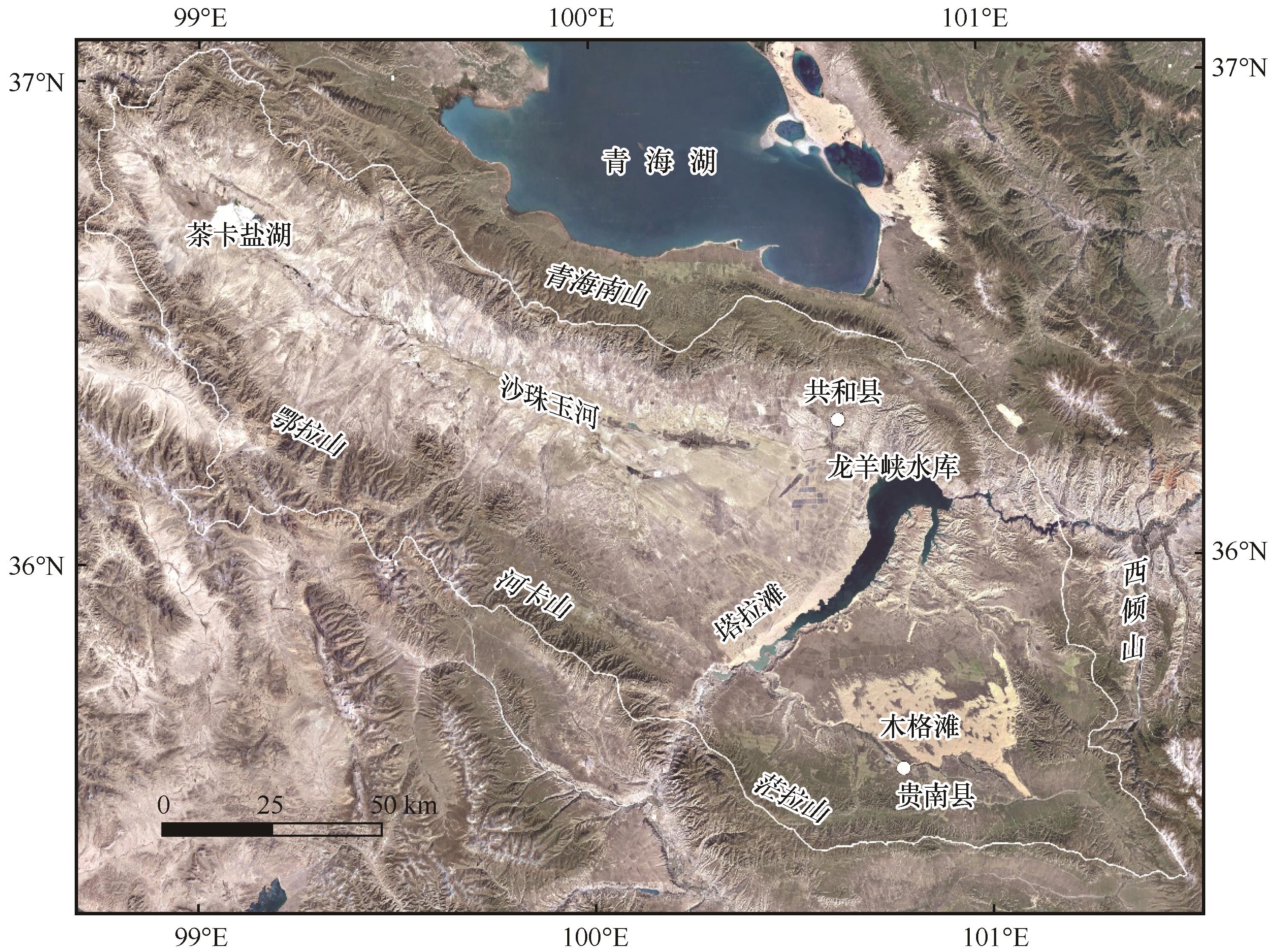
Fig.1 Location of the study area
| 数据类型 | 年份 | 空间分辨率/m | 来源 |
|---|---|---|---|
| DEM | 2020 | 30 | 地理空间数据云(http://www.gscloud.cn) |
| 土壤质地、土壤有机质含量 | 2013 | 1 000 | 世界土壤数据库(HWSD V1.2, http://www.fao.org) |
| NDVI | 2000—2020 | 250 | MOD13Q1 |
| 植被类型 | 2001 | 1 000 | 中国科学院资源环境科学数据中心(https://www.resdc.cn) |
| 土地利用分类 | 2000—2020 | 30 | CLCD (https://doi.org/10.5194/essd-2021-7) |
| 人口分布 | 2000—2020 | 1 000 | World Pop (https://www.worldpop.org/) |
| 气温、降水、风速 | 2000—2020 | 1 000 | 国家地球系统科学数据中心(https://www.geodata.cn/) |
Table 1 Data sources of land desertification sensitivity assessment in the Gonghe Basin
| 数据类型 | 年份 | 空间分辨率/m | 来源 |
|---|---|---|---|
| DEM | 2020 | 30 | 地理空间数据云(http://www.gscloud.cn) |
| 土壤质地、土壤有机质含量 | 2013 | 1 000 | 世界土壤数据库(HWSD V1.2, http://www.fao.org) |
| NDVI | 2000—2020 | 250 | MOD13Q1 |
| 植被类型 | 2001 | 1 000 | 中国科学院资源环境科学数据中心(https://www.resdc.cn) |
| 土地利用分类 | 2000—2020 | 30 | CLCD (https://doi.org/10.5194/essd-2021-7) |
| 人口分布 | 2000—2020 | 1 000 | World Pop (https://www.worldpop.org/) |
| 气温、降水、风速 | 2000—2020 | 1 000 | 国家地球系统科学数据中心(https://www.geodata.cn/) |
| 指标 | 分级 | 描述 | 权重 |
|---|---|---|---|
| 年平均气温 | 1 | <-6 | 1.00 |
| 2 | -6~-2 | 1.33 | |
| 3 | -2~2 | 1.67 | |
| 4 | >2 | 2.00 | |
| 年降水量 | 1 | >500 mm | 1.00 |
| 2 | 410~500 mm | 1.33 | |
| 3 | 320~410 mm | 1.67 | |
| 4 | <320 mm | 2.00 | |
| 年平均风速 | 1 | <1.4 m | 1.00 |
| 2 | 1.4~1.7 m | 1.33 | |
| 3 | 1.7~2 m | 1.67 | |
| 4 | >2 m | 2.00 |
Table 2 Factors and weights of climate quality index
| 指标 | 分级 | 描述 | 权重 |
|---|---|---|---|
| 年平均气温 | 1 | <-6 | 1.00 |
| 2 | -6~-2 | 1.33 | |
| 3 | -2~2 | 1.67 | |
| 4 | >2 | 2.00 | |
| 年降水量 | 1 | >500 mm | 1.00 |
| 2 | 410~500 mm | 1.33 | |
| 3 | 320~410 mm | 1.67 | |
| 4 | <320 mm | 2.00 | |
| 年平均风速 | 1 | <1.4 m | 1.00 |
| 2 | 1.4~1.7 m | 1.33 | |
| 3 | 1.7~2 m | 1.67 | |
| 4 | >2 m | 2.00 |
| 指标 | 分级 | 描述 | 权重 |
|---|---|---|---|
| 侵蚀防护 | 1 | 针叶林、高山植被、其他 | 1.00 |
| 2 | 农田、草原、草甸 | 1.33 | |
| 3 | 灌丛 | 1.67 | |
| 4 | 荒漠 | 2.00 | |
| 抗旱性 | 1 | 针叶林、其他 | 1.00 |
| 2 | 农田、高山植被、灌丛 | 1.33 | |
| 3 | 草原、草甸 | 1.67 | |
| 4 | 荒漠 | 2.00 | |
| NDVI | 1 | >0.4 | 1.00 |
| 2 | 0.3~0.4 | 1.25 | |
| 3 | 0.2~0.3 | 1.50 | |
| 4 | 0.1~0.2 | 1.75 | |
| 5 | <0.1 | 2.00 |
Table 3 Factors and weights of vegetation quality index
| 指标 | 分级 | 描述 | 权重 |
|---|---|---|---|
| 侵蚀防护 | 1 | 针叶林、高山植被、其他 | 1.00 |
| 2 | 农田、草原、草甸 | 1.33 | |
| 3 | 灌丛 | 1.67 | |
| 4 | 荒漠 | 2.00 | |
| 抗旱性 | 1 | 针叶林、其他 | 1.00 |
| 2 | 农田、高山植被、灌丛 | 1.33 | |
| 3 | 草原、草甸 | 1.67 | |
| 4 | 荒漠 | 2.00 | |
| NDVI | 1 | >0.4 | 1.00 |
| 2 | 0.3~0.4 | 1.25 | |
| 3 | 0.2~0.3 | 1.50 | |
| 4 | 0.1~0.2 | 1.75 | |
| 5 | <0.1 | 2.00 |
| 指标 | 类别 | 描述 | 权重 |
|---|---|---|---|
| 土壤含砂量 | 1 | <25% | 1.00 |
| 2 | 25%~40% | 1.33 | |
| 3 | 40%~65% | 1.67 | |
| 4 | >65% | 2.00 | |
| 地形坡度 | 1 | <5 | 1.00 |
| 2 | 5 | 1.33 | |
| 3 | 15 | 1.67 | |
| 4 | >30 | 2.00 | |
| 土壤有机质含量 | 1 | >3% | 1.00 |
| 2 | 2%~3% | 1.33 | |
| 3 | 1%~2% | 1.67 | |
| 4 | <1% | 2.00 |
Table 4 Factors and weights of soil quality index
| 指标 | 类别 | 描述 | 权重 |
|---|---|---|---|
| 土壤含砂量 | 1 | <25% | 1.00 |
| 2 | 25%~40% | 1.33 | |
| 3 | 40%~65% | 1.67 | |
| 4 | >65% | 2.00 | |
| 地形坡度 | 1 | <5 | 1.00 |
| 2 | 5 | 1.33 | |
| 3 | 15 | 1.67 | |
| 4 | >30 | 2.00 | |
| 土壤有机质含量 | 1 | >3% | 1.00 |
| 2 | 2%~3% | 1.33 | |
| 3 | 1%~2% | 1.67 | |
| 4 | <1% | 2.00 |
| 指标 | 分级 | 描述 | 权重 |
|---|---|---|---|
| 人口密度 | 1 | <2 人·km-2 | 1.00 |
| 2 | 2~5 人·km-2 | 1.20 | |
| 3 | 5~10 人·km-2 | 1.40 | |
| 4 | 10~20 人·km-2 | 1.60 | |
| 5 | 20~40 人·km-2 | 1.80 | |
| 6 | >40 人·km-2 | 2.00 | |
| 土地利用强度 | 1 | 林地、灌木、湿地、裸地 | 1.00 |
| 2 | 草地、水体 | 1.50 | |
| 3 | 建设用地、农田 | 2.00 |
Table 5 Factors and weights of land management quality index
| 指标 | 分级 | 描述 | 权重 |
|---|---|---|---|
| 人口密度 | 1 | <2 人·km-2 | 1.00 |
| 2 | 2~5 人·km-2 | 1.20 | |
| 3 | 5~10 人·km-2 | 1.40 | |
| 4 | 10~20 人·km-2 | 1.60 | |
| 5 | 20~40 人·km-2 | 1.80 | |
| 6 | >40 人·km-2 | 2.00 | |
| 土地利用强度 | 1 | 林地、灌木、湿地、裸地 | 1.00 |
| 2 | 草地、水体 | 1.50 | |
| 3 | 建设用地、农田 | 2.00 |

Fig.2 Spatial distribution of climate quality index (A),vegetation quality index (B), soil quality index (C) and management quality index(D) in the Gonghe Basin in 2020
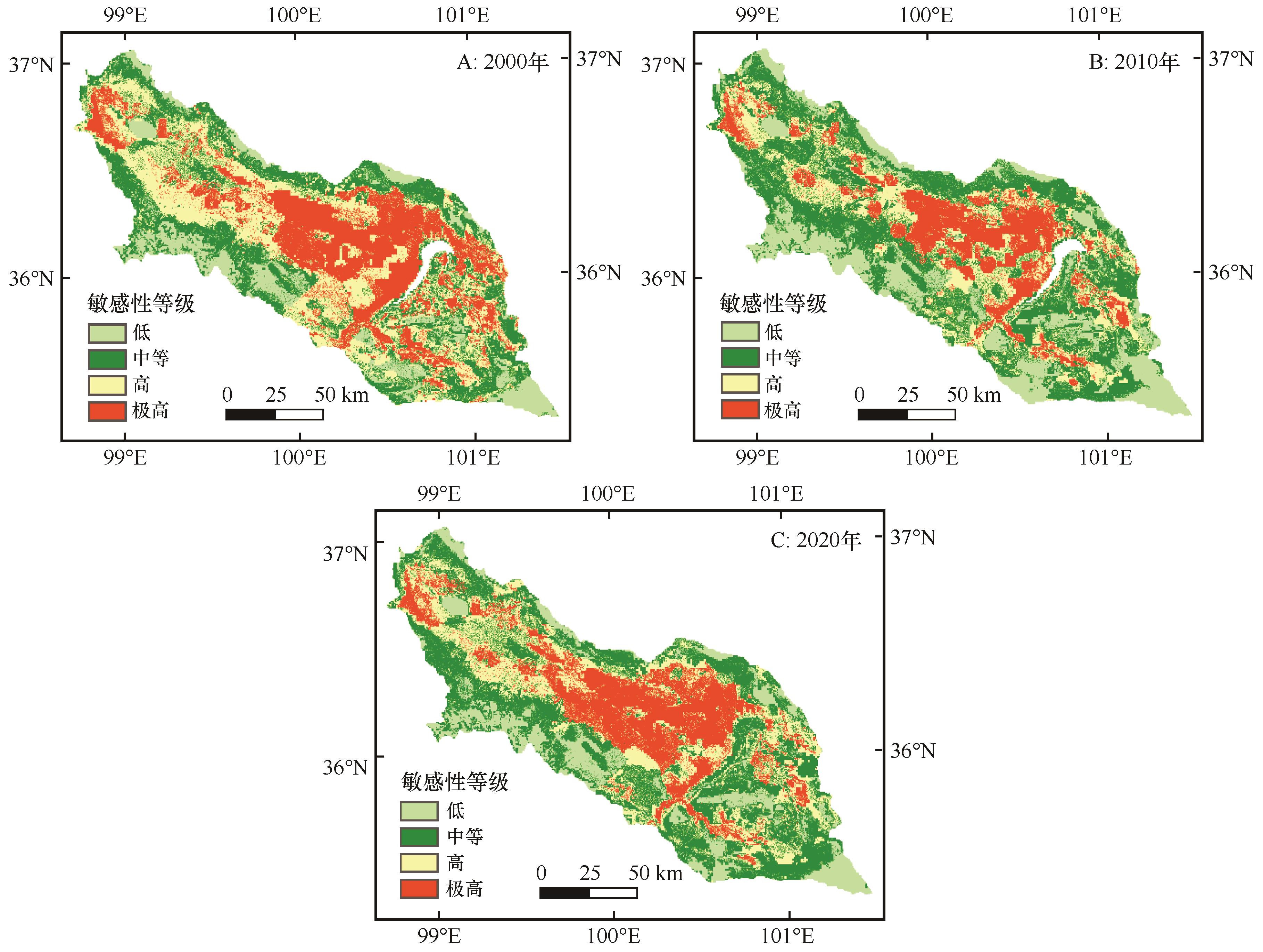
Fig.3 Desertification sensitivity index map of Gonghe Basin from 2000 to 2020
| 年份 | 荒漠化敏感性分级 | |||
|---|---|---|---|---|
| 低 | 中等 | 高 | 极高 | |
| 2000 | 2 721.19 | 5 362.16 | 6 678.57 | 5 051.77 |
| 2010 | 4 422.06 | 7 507.64 | 4 537.99 | 3 342.58 |
| 2020 | 3 267.63 | 7 042.89 | 5 270.27 | 4 400.32 |
Table 6 Area statistics of desertification sensitivity in the Gonghe Basin
| 年份 | 荒漠化敏感性分级 | |||
|---|---|---|---|---|
| 低 | 中等 | 高 | 极高 | |
| 2000 | 2 721.19 | 5 362.16 | 6 678.57 | 5 051.77 |
| 2010 | 4 422.06 | 7 507.64 | 4 537.99 | 3 342.58 |
| 2020 | 3 267.63 | 7 042.89 | 5 270.27 | 4 400.32 |
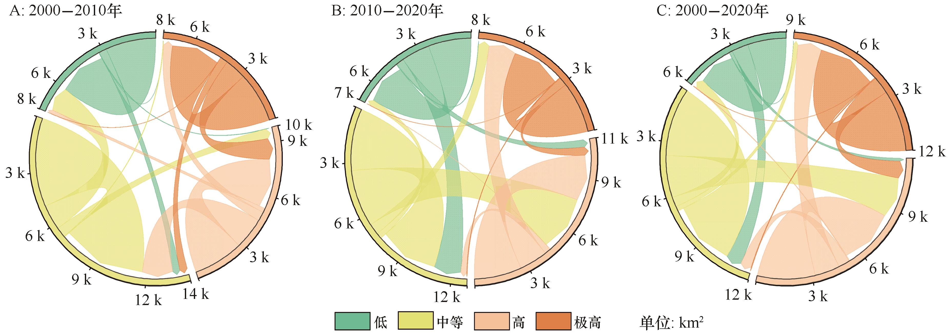
Fig.4 The transfer in desertification sensitivity of the Gonghe Basin from 2000 to 2020
| 荒漠化敏感性指数 | 2000年 | 2010年 | 2020年 |
|---|---|---|---|
| 气候质量指数 | 0.363 | 0.397 | 0.393 |
| 植被质量指数 | 0.398 | 0.320 | 0.321 |
| 土壤质量指数 | 0.293 | 0.303 | 0.290 |
| 管理质量指数 | 0.232 | 0.221 | 0.218 |
Table 7 Geographical detector results of single factor detection
| 荒漠化敏感性指数 | 2000年 | 2010年 | 2020年 |
|---|---|---|---|
| 气候质量指数 | 0.363 | 0.397 | 0.393 |
| 植被质量指数 | 0.398 | 0.320 | 0.321 |
| 土壤质量指数 | 0.293 | 0.303 | 0.290 |
| 管理质量指数 | 0.232 | 0.221 | 0.218 |
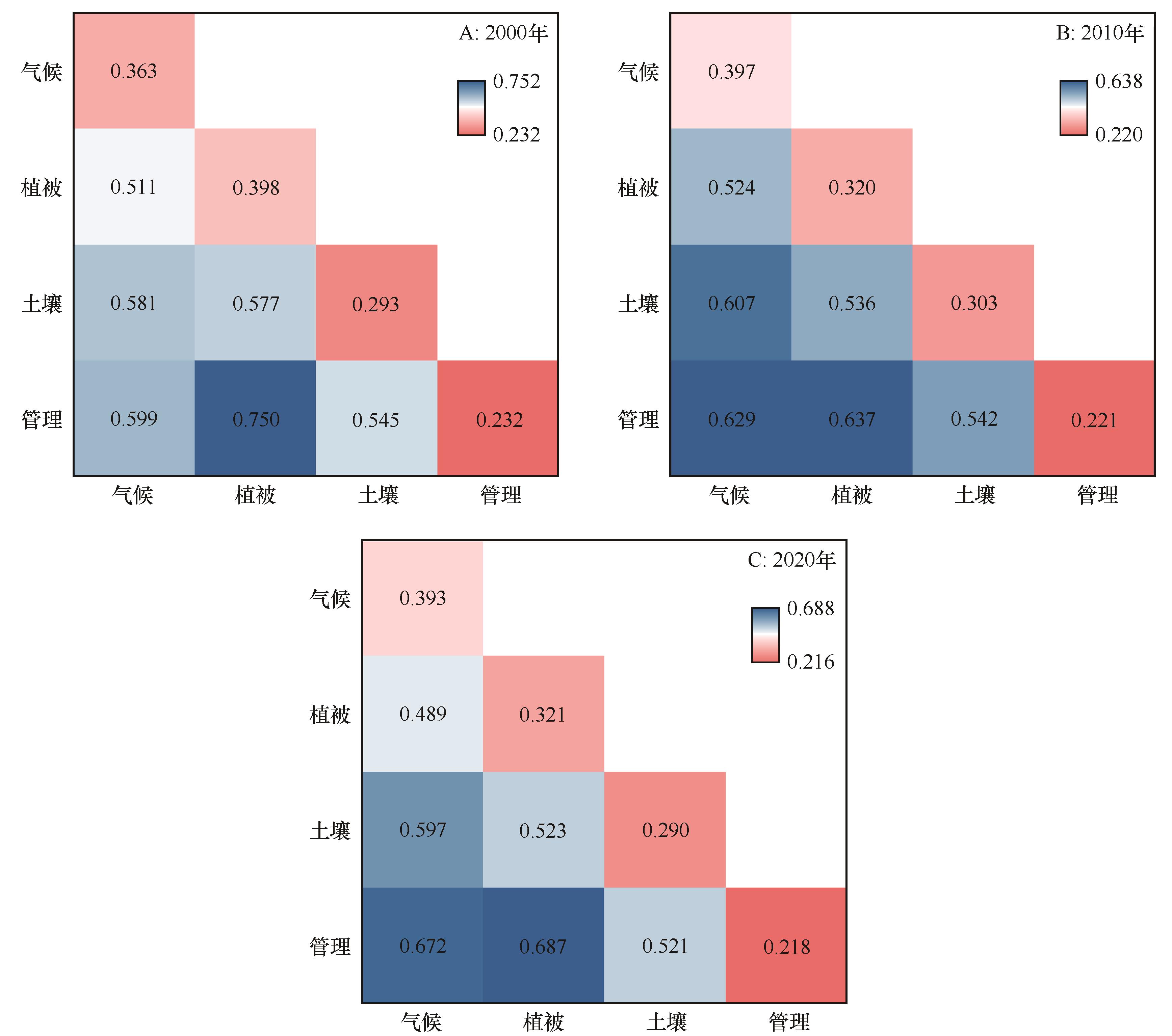
Fig.5 Geographical detector results of interaction detection (P<0.01)
| 1 | United Nations Convention to Combat Desertification.United Nations Convention to Combat Desertification in Countries Experiencing Serious Drought and/or Desertification,Particularly in Africa[R].Paris,France:UNDP,1994. |
| 2 | 王涛,朱震达.我国沙漠化研究的若干问题:1.沙漠化的概念及其内涵[J].中国沙漠,2003,23(3):3-8. |
| 3 | Guo B, Wei C X, Yu Y,et al.The dominant influencing factors of desertification changes in the source region of Yellow River:climate change or human activity?[J].Science of the Total Environment,2022,813:152512. |
| 4 | Xu D, You X, Xia C.Assessing the spatial-temporal pattern and evolution of areas sensitive to land desertification in North China[J].Ecological Indicators,2019,97:150-158. |
| 5 | Kosmas C, Kirkby M, Geeson N.Manual on Key Indicators of Desertification and Mapping Environmentally Sensitive Areas to Desertification[R].European Commission,1999:18882. |
| 6 | Contador J F L, Schnabel S, Gutierrez A G,et al.Mapping sensitivity to land degradation in Extremadura,SW Spain[J].Land Degradation & Development,2009,20(2):129-144. |
| 7 | Salvatil L, Zitti M, Perini L.Fifty years on:long‐term patterns of land sensitivity to desertification in Italy[J].Land Degradation & Development,2016,27(2):97-107. |
| 8 | Karamesouti M, Detsis V, Kounalaki A,et al.Land-use and land degradation processes affecting soil resources:evidence from a traditional Mediterranean cropland (Greece)[J].Catena,2015,132:45-55. |
| 9 | Uzuner Ç, Dengiz O.Desertification risk assessment in Turkey based on environmentally sensitive areas[J].Ecological Indicators,2020,114:106295. |
| 10 | Prăvălie R, Patriche C, Săvulescu I,et al.Spatial assessment of land sensitivity to degradation across Romania:a quantitative approach based on the modified MEDALUS methodology[J].Catena,2020,187:104407. |
| 11 | Wijitkosum S.Factor influencing land degradation sensitivity and desertification in a drought prone watershed in Thailand[J].International Soil and Water Conservation Research,2021,9(2):217-228. |
| 12 | Elnashar A, Zeng H W, Wu B F.Assessment of environmentally sensitive areas to desertification in the blue nile basin driven by the MEDALUS-GEE framework[J].Science of the Total Environment,2022,815:152925. |
| 13 | Jiang L, Bao A, Jiapaer G,et al.Monitoring land sensitivity to desertification in Central Asia:convergence or divergence?[J].Science of the Total Environment,2019,658:669-683. |
| 14 | Shao W Y, Wang Q Z, Guan Q Y,et al.Environmental sensitivity assessment of land desertification in the Hexi Corridor,China[J].Catena,2023,220:106728. |
| 15 | 任雨,张勃,陈曦东.科尔沁沙地土地荒漠化敏感性评估[J].中国沙漠,2023,43(2):159-169. |
| 16 | 吴盈盈,王振亭.疏勒河中下游土地荒漠化敏感性评估[J].中国沙漠,2022,42(4):163-171. |
| 17 | Ren Y, Liu X J, Zhang B,et al.Sensitivity assessment of land desertification in China based on multi-source remote sensing[J].Remote Sensing,2023,15(10):2674. |
| 18 | 董玉祥.青藏高原沙漠化研究的进展与问题[J].中国沙漠,1999,19(3):54-58. |
| 19 | 李森,颜长珍,宋翔,等.近30a龙羊峡水库周边地区沙漠化遥感监测[J].中国沙漠,2011,31(4):836-841. |
| 20 | 张登山.青海共和盆地土地沙漠化影响因子的定量分析[J].中国沙漠,2000,20(1):60-63. |
| 21 | 董光荣,高尚玉,金炯,等.青海共和盆地土地沙漠化与防治途径[M].北京:科学出版社,1993:166-173. |
| 22 | 徐叔鹰,徐德馥,石生仁.青海共和盆地的风沙堆积[J].中国沙漠,1982,2(3):5-12. |
| 23 | Kosmas C, Kairis O, Karavitis C,et al.Evaluation and selection of indicators for land degradation and desertification monitoring:methodological approach[J].Environmental Management,2014,54:951-970. |
| 24 | 李达净,许端阳,丁雪,等.1981-2010年中国北方风蚀气候侵蚀力演变与植被动态响应[J].水土保持研究,2018,25(2):15-20. |
| 25 | 王劲峰,徐成东.地理探测器:原理与展望[J].地理学报,2017,72(1):116-134. |
| 26 | Qiang M, Jin Y, Liu X,et al.Late Pleistocene and Holocene aeolian sedimentation in Gonghe Basin,northeastern Qinghai-Tibetan Plateau:variability,processes,and climatic implications[J].Quaternary Science Reviews,2016,132:57-73. |
| 27 | 郭泽呈,魏伟,石培基,等.中国西北干旱区土地沙漠化敏感性时空格局[J].地理学报,2020,75(9):1948-1965. |
| 28 | 姜旭海,韩玲,白宗璠,等.内蒙古自治区沙漠化敏感性时空演变格局和趋势分析[J].生态学报,2023,43(1):364-378. |
| 29 | Zhang C L, Li Q, Shen Y P,et al.Monitoring of aeolian desertification on the Qinghai-Tibet Plateau from the 1970s to 2015 using Landsat images[J].Science of the Total Environment,2018,619:1648-1659. |
| 30 | Zhou H Y, Hu Z, Geng Q,et al.Monitoring and analysis of desertification surrounding Qinghai Lake (China) using remote sensing big data[J].Environmental Science and Pollution Research,2023,30(7):17420-17436. |
| Viewed | ||||||
|
Full text |
|
|||||
|
Abstract |
|
|||||
©2018Journal of Desert Research
Tel:0931-8267545
Email:caiedit@lzb.ac.cn;desert@lzb.ac.cn
Support:Magtech