
- CN 62-1070/P
- ISSN 1000-694X
- Bimonthly 1981
Journal of Desert Research ›› 2025, Vol. 45 ›› Issue (1): 204-214.DOI: 10.7522/j.issn.1000-694X.2024.00154
Na Gao( ), Guangyin Hu(), Zhibao Dong
Received:2024-09-29
Revised:2024-11-07
Online:2025-01-20
Published:2025-01-13
Contact:
Guangyin Hu
CLC Number:
Na Gao, Guangyin Hu, Zhibao Dong. Change characteristics of spatial distribution pattern of sandy land in Gonghe Basin[J]. Journal of Desert Research, 2025, 45(1): 204-214.
Add to citation manager EndNote|Ris|BibTeX
URL: http://www.desert.ac.cn/EN/10.7522/j.issn.1000-694X.2024.00154
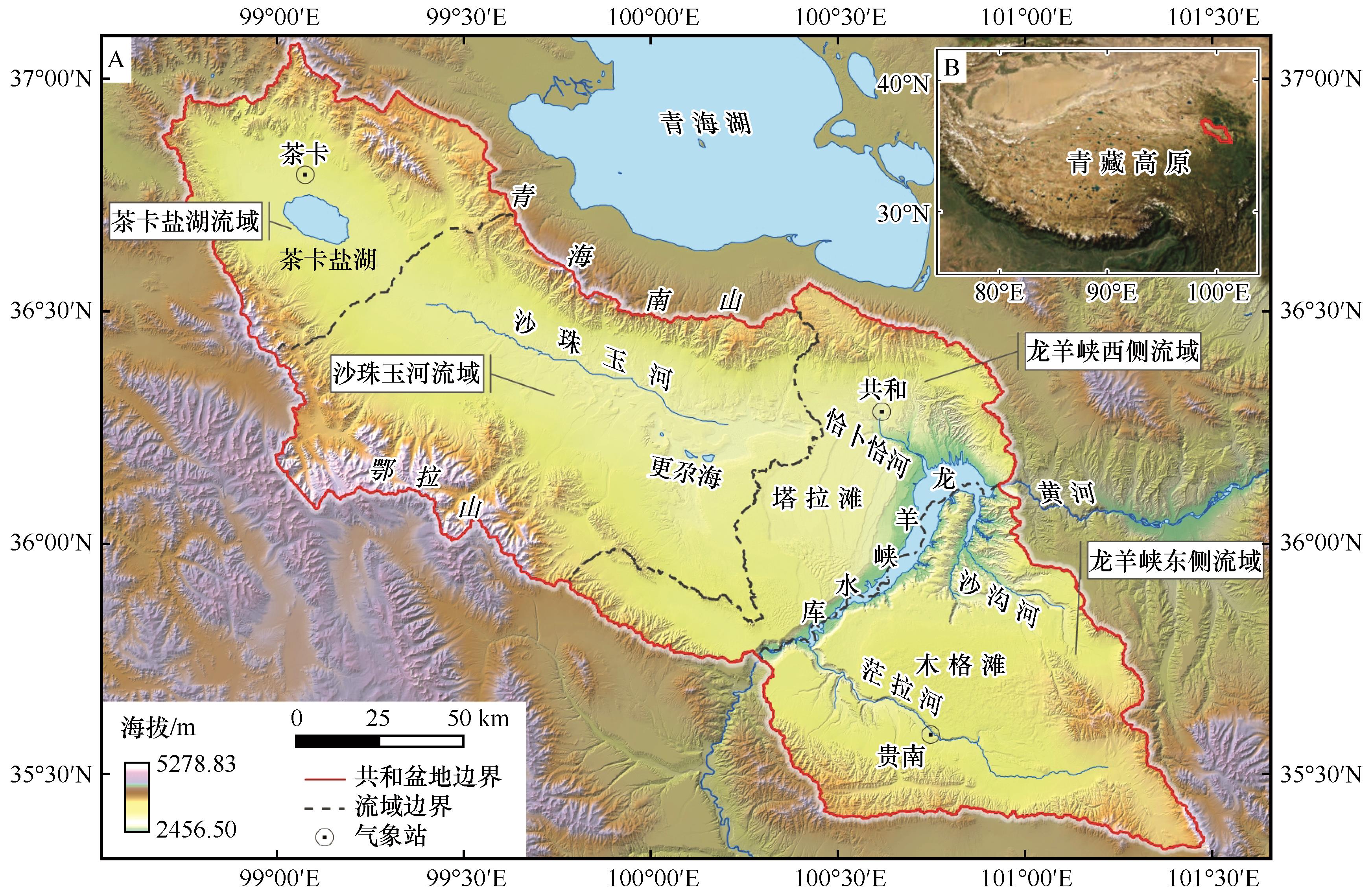
Fig.1 Scope of the study area
| 数据类型 | 数据格式 | 分辨率 | 数据来源 |
|---|---|---|---|
| 土地利用 | 栅格 | 30 m×30 m | http://www.resdc.cn |
| Copernicus数字高程模型 | 栅格 | 30 m×30 m | https://panda.copernicus.eu |
| Landsat遥感影像 | 栅格 | 30 m×30 m | https://earthexplorer.usgs.gov |
Table 1 Data types and sources
| 数据类型 | 数据格式 | 分辨率 | 数据来源 |
|---|---|---|---|
| 土地利用 | 栅格 | 30 m×30 m | http://www.resdc.cn |
| Copernicus数字高程模型 | 栅格 | 30 m×30 m | https://panda.copernicus.eu |
| Landsat遥感影像 | 栅格 | 30 m×30 m | https://earthexplorer.usgs.gov |
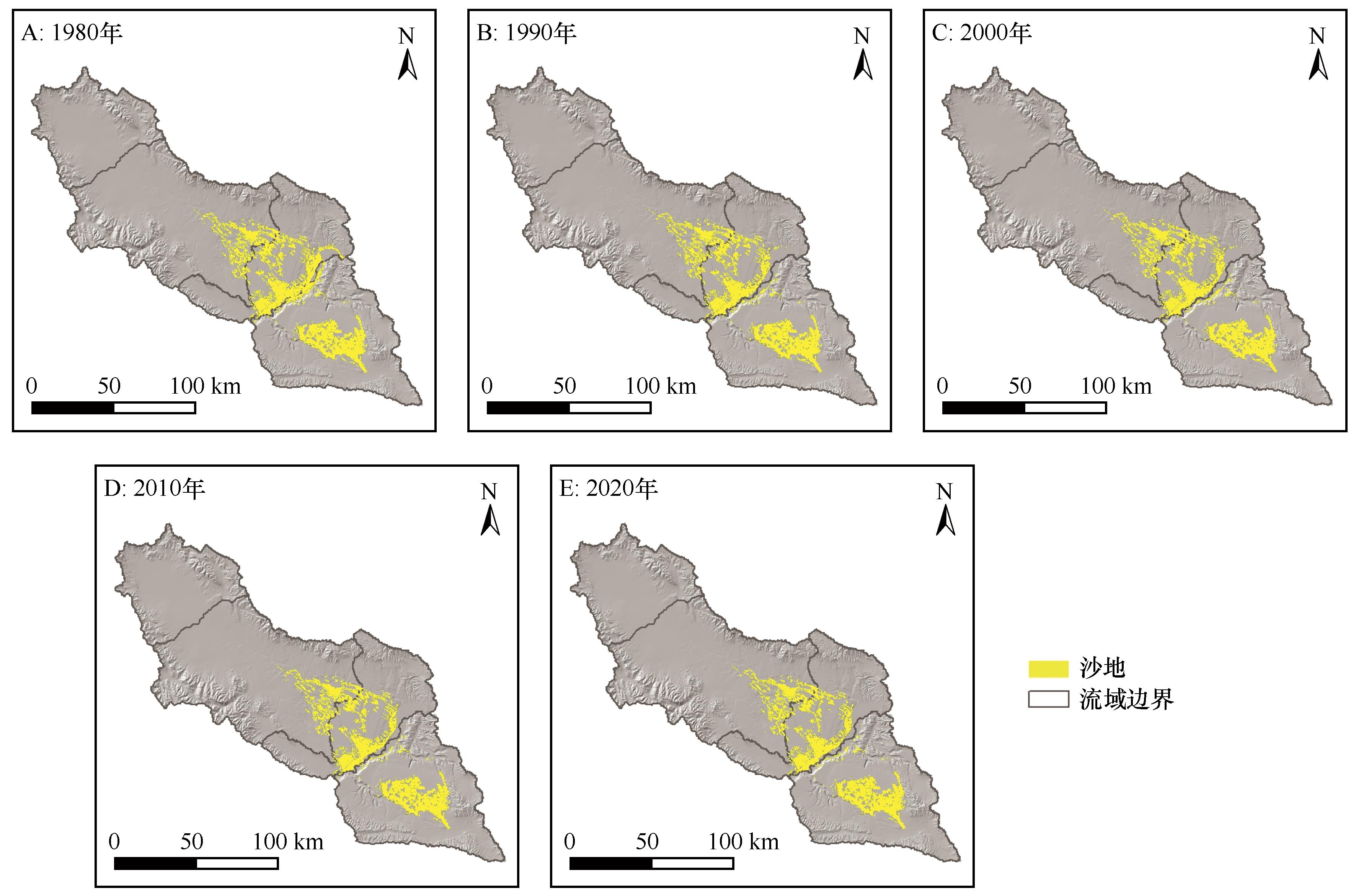
Fig.2 Distribution of sandy land in Gonghe Basin from 1980 to 2020
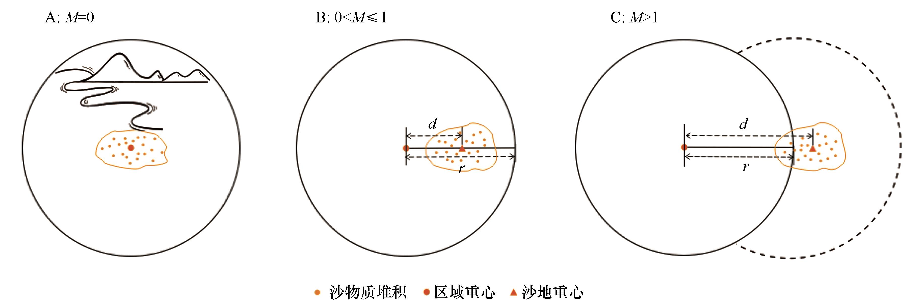
Fig.3 Conceptual model diagram of Migration Intensity
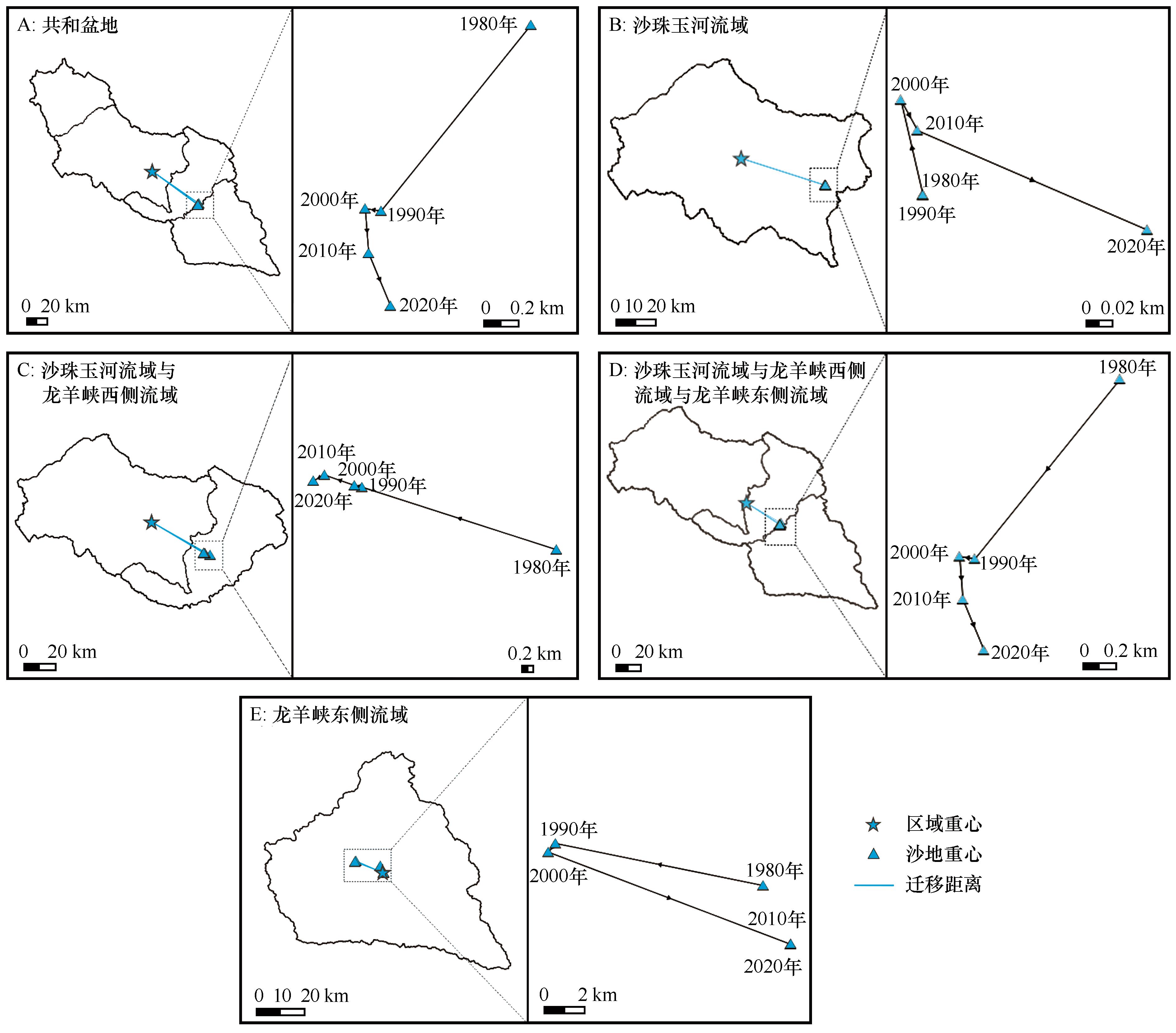
Fig.4 Distribution and changes of sandy land barycenters in Gonghe Basin from 1980 to 2020
| 区域 | 年份 | 沙地重心 | 迁移距离 /km | 迁移方向 /(°) | 迁移度 | 时段 | 沙地重心移动 | ||
|---|---|---|---|---|---|---|---|---|---|
| 经度(E) | 纬度(N) | 距离/km | 角度/(°) | ||||||
| A | 1980 | 100°35′15.544″ | 35°55′05.621″ | 53.13 | 124.86 | 0.41 | \ | \ | \ |
| 1990 | 100°34′42.110″ | 35°54′29.922″ | 53.05 | 126.36 | 0.38 | 1980—1990 | 1.39 | 218.84 | |
| 2000 | 100°34′38.335″ | 35°54′30.232″ | 52.97 | 126.41 | 0.38 | 1990—2000 | 0.09 | 278.53 | |
| 2010 | 100°34′39.637″ | 35°54′22.017″ | 53.14 | 126.62 | 0.38 | 2000—2010 | 0.26 | 175.62 | |
| 2020 | 100°34′45.359″ | 35°54′12.440″ | 53.42 | 126.80 | 0.38 | 2010—2020 | 0.33 | 157.44 | |
| 平均值 | \ | \ | 53.14 | 126.21 | 0.39 | 1980—2020 | 1.83 | 206.56 | |
| B | 1980 | 100°12′35.614″ | 36° 10′55.253″ | 43.41 | 107.87 | 0.83 | \ | \ | \ |
| 1990 | 100°12′35.617″ | 36° 10′55.250″ | 43.41 | 107.87 | 0.83 | 1980—1990 | 0.00 | 141.59 | |
| 2000 | 100°12′34.797″ | 36° 10′57.503″ | 43.37 | 107.79 | 0.82 | 1990—2000 | 0.07 | 346.89 | |
| 2010 | 100°12′35.358″ | 36° 10′56.791″ | 43.39 | 107.81 | 0.83 | 2000—2010 | 0.03 | 151.22 | |
| 2020 | 100°12′42.548″ | 36° 10′54.671″ | 43.58 | 107.83 | 0.83 | 2010—2020 | 0.19 | 113.44 | |
| 平均值 | \ | \ | 43.43 | 107.83 | 0.83 | 1980—2020 | 0.17 | 98.90 | |
| C | 1980 | 100°25′20.430″ | 36°03′16.092″ | 42.92 | 119.56 | 0.65 | \ | \ | \ |
| 1990 | 100°23′05.287″ | 36°03′44.740″ | 39.56 | 120.58 | 0.60 | 1980—1990 | 3.44 | 287.81 | |
| 2000 | 100°23′00.077″ | 36°03′45.477″ | 39.44 | 120.63 | 0.60 | 1990—2000 | 0.13 | 282.90 | |
| 2010 | 100°22′39.249″ | 36°03′50.351″ | 38.91 | 120.79 | 0.59 | 2000—2010 | 0.53 | 289.15 | |
| 2020 | 100°22′31.685″ | 36°03′46.971″ | 38.80 | 121.06 | 0.59 | 2010—2020 | 0.21 | 243.25 | |
| 平均值 | \ | \ | 39.93 | 120.52 | 0.61 | 1980—2020 | 4.26 | 285.82 | |
| D | 1980 | 100°35′15.544″ | 35°55′05.621″ | 31.94 | 120.72 | 0.32 | \ | \ | \ |
| 1990 | 100°34′42.110″ | 35°54′29.922″ | 31.77 | 123.20 | 0.29 | 1980—1990 | 1.39 | 218.84 | |
| 2000 | 100°34′38.335″ | 35°54′30.232″ | 31.69 | 123.27 | 0.29 | 1990—2000 | 0.09 | 278.53 | |
| 2010 | 100°34′39.637″ | 35°54′22.017″ | 31.85 | 123.64 | 0.29 | 2000—2010 | 0.26 | 175.62 | |
| 2020 | 100°34′45.359″ | 35°54′12.440″ | 32.12 | 123.97 | 0.29 | 2010—2020 | 0.33 | 157.44 | |
| 平均值 | \ | \ | 31.88 | 122.96 | 0.30 | 1980—2020 | 1.83 | 206.56 | |
| E | 1980 | 100°50′44.911″ | 35° 42′18.233″ | 3.03 | 340.10 | 0.08 | \ | \ | \ |
| 1990 | 100°43′43.003″ | 35° 43′10.946″ | 12.39 | 293.52 | 0.31 | 1980—1990 | 10.54 | 281.46 | |
| 2000 | 100°43′29.202″ | 35° 42′56.722″ | 12.56 | 291.06 | 0.32 | 1990—2000 | 0.56 | 219.81 | |
| 2010 | 100°51′44.998″ | 35° 40′47.043″ | 0.34 | 102.14 | 0.01 | 2000—2010 | 12.90 | 110.82 | |
| 2020 | 100°51′45.530″ | 35° 40′47.499″ | 0.35 | 99.46 | 0.01 | 2010—2020 | 0.02 | 44.94 | |
| 平均值 | \ | \ | 5.74 | 225.26 | 0.15 | 1980—2020 | 3.22 | 154.67 | |
Table 2 Sandy land barycenters and migration data from 1980 to 2020
| 区域 | 年份 | 沙地重心 | 迁移距离 /km | 迁移方向 /(°) | 迁移度 | 时段 | 沙地重心移动 | ||
|---|---|---|---|---|---|---|---|---|---|
| 经度(E) | 纬度(N) | 距离/km | 角度/(°) | ||||||
| A | 1980 | 100°35′15.544″ | 35°55′05.621″ | 53.13 | 124.86 | 0.41 | \ | \ | \ |
| 1990 | 100°34′42.110″ | 35°54′29.922″ | 53.05 | 126.36 | 0.38 | 1980—1990 | 1.39 | 218.84 | |
| 2000 | 100°34′38.335″ | 35°54′30.232″ | 52.97 | 126.41 | 0.38 | 1990—2000 | 0.09 | 278.53 | |
| 2010 | 100°34′39.637″ | 35°54′22.017″ | 53.14 | 126.62 | 0.38 | 2000—2010 | 0.26 | 175.62 | |
| 2020 | 100°34′45.359″ | 35°54′12.440″ | 53.42 | 126.80 | 0.38 | 2010—2020 | 0.33 | 157.44 | |
| 平均值 | \ | \ | 53.14 | 126.21 | 0.39 | 1980—2020 | 1.83 | 206.56 | |
| B | 1980 | 100°12′35.614″ | 36° 10′55.253″ | 43.41 | 107.87 | 0.83 | \ | \ | \ |
| 1990 | 100°12′35.617″ | 36° 10′55.250″ | 43.41 | 107.87 | 0.83 | 1980—1990 | 0.00 | 141.59 | |
| 2000 | 100°12′34.797″ | 36° 10′57.503″ | 43.37 | 107.79 | 0.82 | 1990—2000 | 0.07 | 346.89 | |
| 2010 | 100°12′35.358″ | 36° 10′56.791″ | 43.39 | 107.81 | 0.83 | 2000—2010 | 0.03 | 151.22 | |
| 2020 | 100°12′42.548″ | 36° 10′54.671″ | 43.58 | 107.83 | 0.83 | 2010—2020 | 0.19 | 113.44 | |
| 平均值 | \ | \ | 43.43 | 107.83 | 0.83 | 1980—2020 | 0.17 | 98.90 | |
| C | 1980 | 100°25′20.430″ | 36°03′16.092″ | 42.92 | 119.56 | 0.65 | \ | \ | \ |
| 1990 | 100°23′05.287″ | 36°03′44.740″ | 39.56 | 120.58 | 0.60 | 1980—1990 | 3.44 | 287.81 | |
| 2000 | 100°23′00.077″ | 36°03′45.477″ | 39.44 | 120.63 | 0.60 | 1990—2000 | 0.13 | 282.90 | |
| 2010 | 100°22′39.249″ | 36°03′50.351″ | 38.91 | 120.79 | 0.59 | 2000—2010 | 0.53 | 289.15 | |
| 2020 | 100°22′31.685″ | 36°03′46.971″ | 38.80 | 121.06 | 0.59 | 2010—2020 | 0.21 | 243.25 | |
| 平均值 | \ | \ | 39.93 | 120.52 | 0.61 | 1980—2020 | 4.26 | 285.82 | |
| D | 1980 | 100°35′15.544″ | 35°55′05.621″ | 31.94 | 120.72 | 0.32 | \ | \ | \ |
| 1990 | 100°34′42.110″ | 35°54′29.922″ | 31.77 | 123.20 | 0.29 | 1980—1990 | 1.39 | 218.84 | |
| 2000 | 100°34′38.335″ | 35°54′30.232″ | 31.69 | 123.27 | 0.29 | 1990—2000 | 0.09 | 278.53 | |
| 2010 | 100°34′39.637″ | 35°54′22.017″ | 31.85 | 123.64 | 0.29 | 2000—2010 | 0.26 | 175.62 | |
| 2020 | 100°34′45.359″ | 35°54′12.440″ | 32.12 | 123.97 | 0.29 | 2010—2020 | 0.33 | 157.44 | |
| 平均值 | \ | \ | 31.88 | 122.96 | 0.30 | 1980—2020 | 1.83 | 206.56 | |
| E | 1980 | 100°50′44.911″ | 35° 42′18.233″ | 3.03 | 340.10 | 0.08 | \ | \ | \ |
| 1990 | 100°43′43.003″ | 35° 43′10.946″ | 12.39 | 293.52 | 0.31 | 1980—1990 | 10.54 | 281.46 | |
| 2000 | 100°43′29.202″ | 35° 42′56.722″ | 12.56 | 291.06 | 0.32 | 1990—2000 | 0.56 | 219.81 | |
| 2010 | 100°51′44.998″ | 35° 40′47.043″ | 0.34 | 102.14 | 0.01 | 2000—2010 | 12.90 | 110.82 | |
| 2020 | 100°51′45.530″ | 35° 40′47.499″ | 0.35 | 99.46 | 0.01 | 2010—2020 | 0.02 | 44.94 | |
| 平均值 | \ | \ | 5.74 | 225.26 | 0.15 | 1980—2020 | 3.22 | 154.67 | |
| 气象 站 | 平均风速 /(m?s-1) | 最大风速 /(m?s-1) | 起沙风 | ||
|---|---|---|---|---|---|
| 平均风速 /(m?s-1) | 频率 /% | 主风向 /(°) | |||
| 茶卡 | 3.1 | 24 | 9.4 | 16.0 | 270.0 |
| 共和 | 1.7 | 22 | 8.1 | 5.3 | 270.0 |
| 贵南 | 1.8 | 19 | 7.2 | 2.5 | 292.5 |
Table 3 Wind speed data from meteorological stations in Gonghe Basin[31]
| 气象 站 | 平均风速 /(m?s-1) | 最大风速 /(m?s-1) | 起沙风 | ||
|---|---|---|---|---|---|
| 平均风速 /(m?s-1) | 频率 /% | 主风向 /(°) | |||
| 茶卡 | 3.1 | 24 | 9.4 | 16.0 | 270.0 |
| 共和 | 1.7 | 22 | 8.1 | 5.3 | 270.0 |
| 贵南 | 1.8 | 19 | 7.2 | 2.5 | 292.5 |

Fig.5 Aeolian-sand relation between the Shazhuyu River Basin & the Western Longyangxia Basin
| 1 | 杨强,李丽,王运动,等.1935-2010年中国人口分布空间格局及其演变特征[J].地理研究,2016,35(8):1547-1560. |
| 2 | 刘涛,齐元静,曹广忠.中国流动人口空间格局演变机制及城镇化效应:基于2000和2010年人口普查分县数据的分析[J].地理学报,2015,70(4):567-581. |
| 3 | Qiao L, Li Y, Liu Y,et al.The spatio‐temporal change of China's net floating population at county scale from 2000 to 2010[J].Asia Pacific Viewpoint,2016,57(3):365-378. |
| 4 | 王思远,张增祥,周全斌,等.近10年中国土地利用格局及其演变[J].地理学报,2002,57(5):523-530. |
| 5 | 刘纪远,刘明亮,庄大方,等.中国近期土地利用变化的空间格局分析[J].中国科学(D辑:地球科学),2002(12):1031-1040,1058-1060. |
| 6 | 朱弘,洪凌涛,任典挺,等.浙江省三门县古树资源特征和空间分布格局分析[J].林业与环境科学,2024,40(4):27-34. |
| 7 | 刘大均,胡静,陈君子,等.中国传统村落的空间分布格局研究[J].中国人口·资源与环境,2014,24(4):157-162. |
| 8 | Chen W, Yang L, Wu J,et al.Spatio‐temporal characteristics and influencing factors of traditional villages in the Yangtze River Basin:a Geodetector model[J].Heritage Science,2023,11(1):111. |
| 9 | Linderson M.Spatial distribution of meso‐scale precipitation in scania,southern sweden[J].Geografiska Annaler:Series A,Physical Geography,2003,85(2):183-196. |
| 10 | Condit R, Ashton P S, Baker P,et al.Spatial patterns in the distribution of tropical tree species[J].Science,2000,288(5470):1414-1418. |
| 11 | 闫海冰,韩有志,杨秀清,等.华北山地典型天然次生林群落的树种空间分布格局及其关联性[J].生态学报,2010,30(9):2311-2321. |
| 12 | 禹朴家,徐海量,乔木,等.玛纳斯河流域土壤类型空间分布格局分析[J].土壤学报,2010,47(6):1050-1059. |
| 13 | Behera S K, Shukla A K.Spatial distribution of surface soil acidity,electrical conductivity,soil organic carbon content and exchangeable potassium,calcium and magnesium in some cropped acid soils of India[J].Land Degradation & Development,2015,26(1):71-79. |
| 14 | Zhu L, Zhang L, Wang J,et al.Combining finite mixture distribution,receptor model,and geostatistical simulation to evaluate heavy metals pollution in soils:source and spatial pattern[J].Land Degradation & Development,2021,32(6):2105-2115. |
| 15 | 徐春霞.末次盛冰期以来共和盆地沙地特征时段空间格局演变研究[D].西宁:青海师范大学,2022. |
| 16 | 冯晗,鹿化煜,弋双文,等.末次盛冰期和全新世大暖期中国季风区西北缘沙漠空间格局重建初探[J].第四纪研究,2013,33(2):252-259. |
| 17 | 赵媛,杨足膺,郝丽莎,等.中国石油资源流动源-汇系统空间格局特征[J].地理学报,2012,67(4):455-466. |
| 18 | 靳诚,陆玉麒.基于县域单元的江苏省经济空间格局演化[J].地理学报,2009,64(6):713-724. |
| 19 | Tobler W R.A computer movie simulating urban growth in the Detroit region[J].Economic Geography,1970,46:234-240. |
| 20 | 董光荣.中国沙漠形成演化气候变化与沙漠化研究[M].北京:海洋出版社,2002. |
| 21 | 徐志伟,鹿化煜.毛乌素沙地风沙环境变化研究的理论和新认识[J].地理学报,2021,76(9):2203-2223. |
| 22 | Abell J T, Pullen A, Lebo Z J,et al.A wind‐albedo‐wind feedback driven by landscape evolution[J].Nature Communications,2020,11(1):96. |
| 23 | 周亚利,鹿化煜,张小艳,等.末次盛冰期和全新世大暖期浑善达克沙地边界的变化[J].第四纪研究,2013,33(2):228-242. |
| 24 | Wang Z.Long‐term dynamics of sandy vegetation and land in North China[J].Remote Sensing,2023,15(19):4803. |
| 25 | Dong X, Chen Z, Wu M,et al.Long time series of remote sensing to monitor the transformation research of Kubuqi Desert in China[J].Earth Science Informatics,2020,13(3):795-809. |
| 26 | 董治宝.青藏高原风沙地貌图集[M].西安:西安地图出版社,2017. |
| 27 | 董光荣,高尚玉,金炯,等.青海共和盆地土地沙漠化与防治途径[M].北京:科学出版社,1993. |
| 28 | 徐叔鹰,徐德馥,石生仁.青海共和盆地的风沙堆积[J].中国沙漠,1982,2(3):5-12. |
| 29 | 徐叔鹰,徐德馥,石生仁.共和盆地地貌发育与环境演化探讨[J].兰州大学学报(自然科学版),1984(1):146-157. |
| 30 | 赵希涛,杨艳,贾丽云,等.论晚期共和古湖时代、演化过程及其与地壳运动和黄河发育的关系[J].地球学报,2021,42(4):451-471. |
| 31 | 陈宗颜,董治宝,汪青春.青海共和盆地风况及风沙地貌[J].中国沙漠,2018,38(3):492-499. |
| 32 | 高尚玉,王贵勇,哈斯,等.末次冰期以来中国季风区西北边缘沙漠演化研究[J].第四纪研究,2001,21(1):66-71. |
| 33 | 刘冰,靳鹤龄,孙忠,等.全新世共和盆地沙地时空演化及其驱动机制[J].中国沙漠,2014,34(4):982-991. |
| 34 | Dörwald L, Lehmkuhl F, Walk J,et al.Dune movement under climatic changes on the north‐eastern Tibetan Plateau as recorded by long‐term satellite observation versus ERA‐5 reanalysis[J].Earth Surface Processes and Landforms,2023,48(13):2613-2629. |
| 35 | 闫蓉,安光辉.共和盆地近60年来气候变化特征分析[J].农业灾害研究,2021,11(1):117-120. |
| 36 | Shao M, Luo W, Che X,et al.UAV‐SfM‐based field quantification of barchan dune celerity and morphodynamics in Gonghe Basin[J].Earth Surface Processes and Landforms,2024,49(8):2380-2404. |
| 37 | 曾永年,冯兆东,曹广超.基于GIS的黄河上游龙羊峡库区生态环境遥感监测研究[J].山地学报,2003(2):140-148. |
| 38 | 王吉玉,张兴鲁.青海省共和盆地的第四纪地层[J].地质论评,1979(2):15-20. |
| 39 | 王劲峰.区域社会-经济空间结构与行为分析的重心方法及实验研究[J].遥感信息,1993(2):11-14. |
| 40 | 高志强,刘纪远,庄大方.我国耕地面积重心及耕地生态背景质量的动态变化[J].自然资源学报,1998(1):92-96. |
| 41 | Riao D, Zhu X, Tong Z,et al.Study on land use/cover change and ecosystem services in Harbin,China[J].Sustainability,2020,12(15):6076. |
| 42 | Janus J.Measuring land fragmentation considering the shape of transportation network:a method to increase the accuracy of modeling the spatial structure of agriculture with case study in Poland[J].Computers and Electronics in Agriculture,2018,148:259-271. |
| 43 | Xie J, Lu Z, Xiao S,et al.The latest desertification process and its driving force in Alxa League from 2000 to 2020[J].Remote Sensing,2023,15(19):4867. |
| 44 | 陈宗颜,董治宝,鄂崇毅,等.1971-2015年共和盆地风况特征及变化趋势[J].兰州大学学报(自然科学版),2020,56(2):224-230. |
| 45 | Luo W, Wang Z, Shao M,et al.Historical evolution and controls on mega‐blowouts in northeastern Qinghai‐Tibetan Plateau,China[J].Geomorphology,2019,329:17-31. |
| 46 | 高宏智,邹桂香.龙羊峡水库周围风沙流的观测、计算及对库区的影响[J].干旱区资源与环境,1989(1):59-69. |
| 47 | Kocurek G, Lancaster N.Aeolian system sediment state:theory and Mojave Desert Kelso dune field example[J].Sedimentology,1999,46(3):505-515. |
| 48 | 董治宝,苏志珠,钱广强,等.库姆塔格沙漠风沙地貌[M].北京:科学出版社,2011. |
| 49 | Jiang Q, Li Z, Hao Q.Modern sand supply of the Tengger Desert and temporal variations in sand provenance driven by northern Hemisphere glaciation[J].Catena,2022,214:106278. |
| 50 | Lancaster N, Baas A.Influence of vegetation cover on sand transport by wind:field studies at Owens Lake,California[J].Earth Surface Processes and Landforms,1998,23(1):69-82. |
| 51 | Kuriyama Y, Mochizuki N, Nakashima T.Influence of vegetation on aeolian sand transport rate from a backshore to a foredune at Hasaki,Japan[J].Sedimentology,2005,52(5):1123-1132. |
| 52 | 苏万峰,汉光昭,叶得力,等.共和盆地生态环境遥感评价及驱动力分析[J].中国沙漠,2023,43(5):74-84. |
| 53 | 邵梅,罗万银,车雪华,等.基于COSI-Corr技术的龙羊峡库区1987-2019年风沙输移特征及潜在入库量估算[J].中国沙漠,2021,41(6):249-261. |
| 54 | Gillette D A, Chen W.Particle production and aeolian transport from a “supply-limited” source area in the Chihuahuan desert,New Mexico,United States[J].Journal of Geophysical Research:Atmospheres,2001,106(D6):5267-5278. |
| 55 | 胡光印,董治宝,杨林海,等.共和盆地土地利用/覆盖变化(LUCC)及其驱动因素[J/OL].地球环境学报,1-20[2024-11-04].. |
| [1] | Hong Jia, Lianyou Liu, Jifu Liu. Desertification sensitivity assessment in the Gonghe Basin [J]. Journal of Desert Research, 2025, 45(1): 1-9. |
| [2] | Jing Zhang, Xiaoan Zuo, Peng Lv. Effects of changes in growing season precipitation regimes on plant community structure, function and aboveground biomass in typical habitats in the Horqin Sandy Land [J]. Journal of Desert Research, 2024, 44(4): 1-13. |
| [3] | Hanchen Duan, Beiying Huang. Comprehensive evaluation of land desertification sensitivity in the Horqin Sandy Land based on the coupling of AHP and improved MEDALUS model [J]. Journal of Desert Research, 2024, 44(4): 137-148. |
| [4] | Shuai Wang, Dengke Ma, Zhibin He, Weihao Sun, Jun Du, Rui Li, Wen Wang, Shuping Yang, Shuxuan Zhao. Vegetation diversity and its relationship with soil physical and chemical properties in Hedong Sandy Land, Ningxia [J]. Journal of Desert Research, 2024, 44(4): 202-211. |
| [5] | Jiannan Lu, Yuqiang Li, Xueyong Zhao, Baocheng Li, Xuyang Wang, Rui Zhang. Characteristics of ecological environment changes and advices for combating desertification in typical semi-arid sandy land [J]. Journal of Desert Research, 2024, 44(4): 284-292. |
| [6] | Eryan Liu, Yuanyuan Zhao, Die Zhou, Haiyan Wu, Guanglei Gao, Guodong Ding. Spatiotemporal variation patterns of land desertification from 2000 to 2020 in the Horqin-Otindag Sandy Land [J]. Journal of Desert Research, 2024, 44(4): 46-56. |
| [7] | Cong Hua, Yun Cao, Jikang Wang, Ran Xu. Spring sand-dust weather distribution in Hunshandak Sandy Land in relation to vegetation and wind in 2000-2023 [J]. Journal of Desert Research, 2024, 44(4): 71-80. |
| [8] | Xiaoyu Han, Yunping Chi, Yuanyun Xie, Chunguo Kang, Peng Wu, Yehui Wang, Lei Sun, Zhengyu Wei. Material composition characteristics of fine particles of eolian sand in Horqin Sandy Land and its indication to provenance [J]. Journal of Desert Research, 2024, 44(3): 231-246. |
| [9] | Jiaqi Wang, Xiaomei Li, Xiaokang Liu, Miao Dong. Landscape pattern and variation of riparian dunes and the aeolian-fluvial interaction in the upper reaches of Wuding River in Mu Us Sandy Land [J]. Journal of Desert Research, 2024, 44(3): 31-41. |
| [10] | Mingyu Cai, Biao Jia, Xueli Chang. Impact of interaction of landscape pattern factors on desertification status in Kerqin Sandy Land [J]. Journal of Desert Research, 2024, 44(2): 99-108. |
| [11] | Tianling Bao, Jiliang Liu, Feng Yuan, Yinlong Li, Zhenyu Jia, Chengchen Pan. Response of plant community to experimental warming in Horqin Sandy Land [J]. Journal of Desert Research, 2024, 44(1): 151-160. |
| [12] | Jiaxin Feng, Yueru Wu, Shuo Qiao, Xiya Liu, Haibing Wang. Characteristics of changes in soil components and trace element contents during the reversal of desertification in Mu Us Sandy Land [J]. Journal of Desert Research, 2024, 44(1): 218-227. |
| [13] | Wanfeng Su, Guangzhao Han, Deli Ye, Guangchao Cao. Remote sensing evaluation and driving force analysis of ecological environment in Gonghe Basin [J]. Journal of Desert Research, 2023, 43(5): 74-84. |
| [14] | Yanzhuo Zhao, Yuanyun Xie, Chunguo Kang, Yunping Chi, Lei Sun, Peng Wu, Zhenyu Wei. Holocene climate change recorded by paleosoil profile in Hulun Buir Sandy Land [J]. Journal of Desert Research, 2023, 43(5): 85-96. |
| [15] | Xueyang Guo, Linhai Yang, Liangqing Cheng, Guangyin Hu, Jingjing Hu. Physical and chemical characteristics of aeolian sands in Jiudong Sandy Land of Hexi Corridor and its environmental significance [J]. Journal of Desert Research, 2023, 43(4): 17-30. |
| Viewed | ||||||
|
Full text |
|
|||||
|
Abstract |
|
|||||
©2018Journal of Desert Research
Tel:0931-8267545
Email:caiedit@lzb.ac.cn;desert@lzb.ac.cn
Support:Magtech