
- CN 62-1070/P
- ISSN 1000-694X
- Bimonthly 1981
Journal of Desert Research ›› 2025, Vol. 45 ›› Issue (4): 211-226.DOI: 10.7522/j.issn.1000-694X.2025.00066
Delong Zhou1( ), Yongfang Wang1,2,3(), Enliang Guo1,2, Ying Hong1,2, Haowen Ma1, Quanfei Mu1, Yanli Wang1
Received:2025-02-28
Revised:2025-05-31
Online:2025-07-20
Published:2025-08-18
Contact:
Yongfang Wang
CLC Number:
Delong Zhou, Yongfang Wang, Enliang Guo, Ying Hong, Haowen Ma, Quanfei Mu, Yanli Wang. Evolution and prediction of habitat quality in the Horqin Sandy Land[J]. Journal of Desert Research, 2025, 45(4): 211-226.
Add to citation manager EndNote|Ris|BibTeX
URL: http://www.desert.ac.cn/EN/10.7522/j.issn.1000-694X.2025.00066

Fig.1 Study area boundary map
| 驱动因子/单位 | 空间分辨率 | 时间(年份) | 数据来源 |
|---|---|---|---|
| 海拔/m | 30 m | 2000 | NASA官网(https://www.nasa.gov) |
| 坡度/m | |||
| 归一化植被指数(Normalized Difference Vegetation Index,NDVI)/(无量纲) | 1 km | 2000—2022 | NASA地球观测数据(https://earthdata.nasa.gov) |
| 净初级生产力(Net Primary Productivity,NPP)/(kg·m-2·a-1) | 1 km | 地理空间数据云(www.gis5g.com) | |
| 叶面积指数(Leaf Area Index,LAI)/(m2·m-2) | 500 m | NASA官网(https://modaps.modaps.eos⁃dis.nasa.gov/) | |
| 潜在蒸散量/mm | 0.042° | 1990—2022 | Terra Climate数据集(https://climate.northwestknowledge.net/) |
| 地表径流/mm | |||
| 土壤湿度/mm | |||
| 风速/(m·s-1) | |||
| 降水/mm | 1 km | 1990—2022 | 国家青藏高原数据中心(https://data.tpdc.ac.cn/home) |
| 气温/℃ | |||
| 牲畜数量/头 | 0.083° | 2015 | 粮农组织牲畜系统(https://www.fao.org/livestock⁃systems/zh/) |
| GDP/万元 | 1 km | 2000—2020 | 地理空间数据云(www.gis5g.com) |
| 人口密度/(人·km-2) | WorldPop官网(https://hub.worldpop.org) |
Table 1 Description of driving factor data
| 驱动因子/单位 | 空间分辨率 | 时间(年份) | 数据来源 |
|---|---|---|---|
| 海拔/m | 30 m | 2000 | NASA官网(https://www.nasa.gov) |
| 坡度/m | |||
| 归一化植被指数(Normalized Difference Vegetation Index,NDVI)/(无量纲) | 1 km | 2000—2022 | NASA地球观测数据(https://earthdata.nasa.gov) |
| 净初级生产力(Net Primary Productivity,NPP)/(kg·m-2·a-1) | 1 km | 地理空间数据云(www.gis5g.com) | |
| 叶面积指数(Leaf Area Index,LAI)/(m2·m-2) | 500 m | NASA官网(https://modaps.modaps.eos⁃dis.nasa.gov/) | |
| 潜在蒸散量/mm | 0.042° | 1990—2022 | Terra Climate数据集(https://climate.northwestknowledge.net/) |
| 地表径流/mm | |||
| 土壤湿度/mm | |||
| 风速/(m·s-1) | |||
| 降水/mm | 1 km | 1990—2022 | 国家青藏高原数据中心(https://data.tpdc.ac.cn/home) |
| 气温/℃ | |||
| 牲畜数量/头 | 0.083° | 2015 | 粮农组织牲畜系统(https://www.fao.org/livestock⁃systems/zh/) |
| GDP/万元 | 1 km | 2000—2020 | 地理空间数据云(www.gis5g.com) |
| 人口密度/(人·km-2) | WorldPop官网(https://hub.worldpop.org) |
| 胁迫因子 | 最大影响距离 | 权重 | 衰退相关性 |
|---|---|---|---|
| 耕地 | 10 | 0.7 | 线性衰退 |
| 未利用地 | 5 | 0.6 | 指数衰退 |
| 建设用地 | 12 | 1 | 指数衰退 |
Table 2 Weight setting for stress factors
| 胁迫因子 | 最大影响距离 | 权重 | 衰退相关性 |
|---|---|---|---|
| 耕地 | 10 | 0.7 | 线性衰退 |
| 未利用地 | 5 | 0.6 | 指数衰退 |
| 建设用地 | 12 | 1 | 指数衰退 |
| 土地利用类型 | 生境适宜性 | 耕地 | 未利用地 | 建设用地 |
|---|---|---|---|---|
| 耕地 | 0.7 | 0.5 | 0.1 | 1 |
| 林地 | 1 | 0.65 | 0.6 | 0.75 |
| 草地 | 1 | 0.5 | 0.4 | 0.6 |
| 水域 | 1 | 0.2 | 0.2 | 0.4 |
| 建设用地 | 0 | 0 | 0 | 0 |
| 未利用地 | 0 | 0 | 0 | 0 |
Table 3 Habitat sensitivity settings
| 土地利用类型 | 生境适宜性 | 耕地 | 未利用地 | 建设用地 |
|---|---|---|---|---|
| 耕地 | 0.7 | 0.5 | 0.1 | 1 |
| 林地 | 1 | 0.65 | 0.6 | 0.75 |
| 草地 | 1 | 0.5 | 0.4 | 0.6 |
| 水域 | 1 | 0.2 | 0.2 | 0.4 |
| 建设用地 | 0 | 0 | 0 | 0 |
| 未利用地 | 0 | 0 | 0 | 0 |
| Z | 趋势变化类型 | |
|---|---|---|
| ≥0.0005 | >1.96 | 显著提升 |
| ≥0.0005 | -1.96 ~1.96 | 轻微提升 |
| -0.0005~0.0005 | -1.96~1.96 | 稳定不变 |
| <-0.0005 | -1.96~1.96 | 轻微退化 |
| <-0.0005 | <-1.96 | 显著退化 |
Table 4 Theil-Sen Median trend change type discrimination criteria
| Z | 趋势变化类型 | |
|---|---|---|
| ≥0.0005 | >1.96 | 显著提升 |
| ≥0.0005 | -1.96 ~1.96 | 轻微提升 |
| -0.0005~0.0005 | -1.96~1.96 | 稳定不变 |
| <-0.0005 | -1.96~1.96 | 轻微退化 |
| <-0.0005 | <-1.96 | 显著退化 |
| 判别标准 | 交互类型 |
|---|---|
| 非线性减弱 | |
| 单因子非线性减弱 | |
| 双因子增强 | |
| 独立 | |
| 非线性增强 |
Table 5 Types of geographical detector interactions and their discrimination criteria
| 判别标准 | 交互类型 |
|---|---|
| 非线性减弱 | |
| 单因子非线性减弱 | |
| 双因子增强 | |
| 独立 | |
| 非线性增强 |
Table 6 Outlines the scenario settings and conditions for land use predictions
| 土地利用类型 | 耕地 | 林地 | 草地 | 水域 | 建设用地 | 未利用地 |
|---|---|---|---|---|---|---|
| 经济价值系数/(万元·km-2) | 1.63 | 0.056 | 3.58 | 1.24 | 151.43 | 0 |
| 生态价值系数/(万元·km-2) | 0.98 | 4.90 | 3.00 | 31.26 | 0 | 4.42 |
Table 7 Coefficients of ecological and economic values of land use types in the Horqin Sandy Land by 2035
| 土地利用类型 | 耕地 | 林地 | 草地 | 水域 | 建设用地 | 未利用地 |
|---|---|---|---|---|---|---|
| 经济价值系数/(万元·km-2) | 1.63 | 0.056 | 3.58 | 1.24 | 151.43 | 0 |
| 生态价值系数/(万元·km-2) | 0.98 | 4.90 | 3.00 | 31.26 | 0 | 4.42 |
| 约束类型 | 约束因素 | 约束表达式 | 约束条件解译 | |
|---|---|---|---|---|
| 总量 | 土地面积 | 各情景下土地利用总面积等于研究区面积 | ||
| 耕地红线 | 耕地面积 | 45538.38≤ | 由于科尔沁沙地耕地面积不断减少,以马尔科夫链预测的2035年耕地面积作为下限,以2022年耕地保有量作为上限 | |
| 林地 | 林地面积 | 8285.49≤ | 根据《全国重要生态系统保护和修复重大工程总体规划(2021—2035年)》,将全面加强科尔沁退化草原和已垦草原治理。因此,科尔沁沙地的林地会有所增加,将林地面积的下限设置为2022年林地面积,上限为马尔科夫链预测的2035年林地面积 | |
| 草地 | 草地面积 | 61152.03≤ | 随着科尔沁沙地实施了一系列生态保护和恢复政策,草原退化的趋势有所减缓。以马尔科夫链预测的2035年草原面积为上限,下限为2022年草地面积 | |
| 水域 | 水域面积 | 211.32≤ | 基于《内蒙古自治区“十四五”生态环境保护规划》,以西辽河流域为重点,逐步恢复水域生态功能。因此,以马尔科夫链预测的2035年水域面积作为上限,以2022年的水域面积作为下限 | |
| 建设用地 | 建设用地面积 | 3613.32≤ | 根据1990—2022年土地利用用地面积统计结果,科尔沁沙地建设用地面积不断增长。所以,以2022年建设用地面积为下限,以马尔科夫链预测的2035年建设用地面积为上限 | |
| 未利用地 | 未利用地面积 | 3357.63≤ | 科尔沁沙地1990—2022年未利用土地面积不断减少,因此上限为2022年未利用地面积,以马尔科夫链预测的2035的未利用地作为下限 | |
| 农用地 | 耕、林、草地面积 | 农业用地面积保持动态均衡,且不低于现状面积 | ||
| 生态多样性 | 林、草、水域面积 | 各优化情景下生态多样性总面积不低于现状面积 | ||
Table 8 Forecast constraints on land use in the Horqin Sandy Land
| 约束类型 | 约束因素 | 约束表达式 | 约束条件解译 | |
|---|---|---|---|---|
| 总量 | 土地面积 | 各情景下土地利用总面积等于研究区面积 | ||
| 耕地红线 | 耕地面积 | 45538.38≤ | 由于科尔沁沙地耕地面积不断减少,以马尔科夫链预测的2035年耕地面积作为下限,以2022年耕地保有量作为上限 | |
| 林地 | 林地面积 | 8285.49≤ | 根据《全国重要生态系统保护和修复重大工程总体规划(2021—2035年)》,将全面加强科尔沁退化草原和已垦草原治理。因此,科尔沁沙地的林地会有所增加,将林地面积的下限设置为2022年林地面积,上限为马尔科夫链预测的2035年林地面积 | |
| 草地 | 草地面积 | 61152.03≤ | 随着科尔沁沙地实施了一系列生态保护和恢复政策,草原退化的趋势有所减缓。以马尔科夫链预测的2035年草原面积为上限,下限为2022年草地面积 | |
| 水域 | 水域面积 | 211.32≤ | 基于《内蒙古自治区“十四五”生态环境保护规划》,以西辽河流域为重点,逐步恢复水域生态功能。因此,以马尔科夫链预测的2035年水域面积作为上限,以2022年的水域面积作为下限 | |
| 建设用地 | 建设用地面积 | 3613.32≤ | 根据1990—2022年土地利用用地面积统计结果,科尔沁沙地建设用地面积不断增长。所以,以2022年建设用地面积为下限,以马尔科夫链预测的2035年建设用地面积为上限 | |
| 未利用地 | 未利用地面积 | 3357.63≤ | 科尔沁沙地1990—2022年未利用土地面积不断减少,因此上限为2022年未利用地面积,以马尔科夫链预测的2035的未利用地作为下限 | |
| 农用地 | 耕、林、草地面积 | 农业用地面积保持动态均衡,且不低于现状面积 | ||
| 生态多样性 | 林、草、水域面积 | 各优化情景下生态多样性总面积不低于现状面积 | ||

Fig.2 Habitat quality classification in Horqin Sandy Land, 1990 and 2022
| 生境质量等级 | 1990—2000年 | 2001—2011年 | 2012—2022年 | 1990—2022年 | ||||
|---|---|---|---|---|---|---|---|---|
| 面积变化/km2 | 动态度/% | 面积变化/km2 | 动态度/% | 面积变化/km2 | 动态度/% | 面积变化/km2 | 动态度/% | |
| 低 | 71.44 | 0.09 | -251.62 | -0.33 | -105.06 | -0.15 | -904.79 | -1.29 |
| 较低 | -5 554.58 | -6.44 | 184.54 | 0.22 | 4 161.76 | 3.04 | -962.47 | -0.70 |
| 一般 | 684.49 | 0.18 | -941.83 | -0.26 | -1 652.36 | -0.48 | -3 566.45 | -1.04 |
| 较高 | 963.76 | 0.73 | -714.8 | -0.57 | 69.31 | 0.06 | 360.37 | 0.29 |
| 高 | 3 833.71 | 0.56 | 1 725.02 | 0.24 | -2 578.91 | -0.37 | 4 969.5 | 0.71 |
Table 9 Changes in habitat quality area and dynamics by grade from 1990 to 2022
| 生境质量等级 | 1990—2000年 | 2001—2011年 | 2012—2022年 | 1990—2022年 | ||||
|---|---|---|---|---|---|---|---|---|
| 面积变化/km2 | 动态度/% | 面积变化/km2 | 动态度/% | 面积变化/km2 | 动态度/% | 面积变化/km2 | 动态度/% | |
| 低 | 71.44 | 0.09 | -251.62 | -0.33 | -105.06 | -0.15 | -904.79 | -1.29 |
| 较低 | -5 554.58 | -6.44 | 184.54 | 0.22 | 4 161.76 | 3.04 | -962.47 | -0.70 |
| 一般 | 684.49 | 0.18 | -941.83 | -0.26 | -1 652.36 | -0.48 | -3 566.45 | -1.04 |
| 较高 | 963.76 | 0.73 | -714.8 | -0.57 | 69.31 | 0.06 | 360.37 | 0.29 |
| 高 | 3 833.71 | 0.56 | 1 725.02 | 0.24 | -2 578.91 | -0.37 | 4 969.5 | 0.71 |
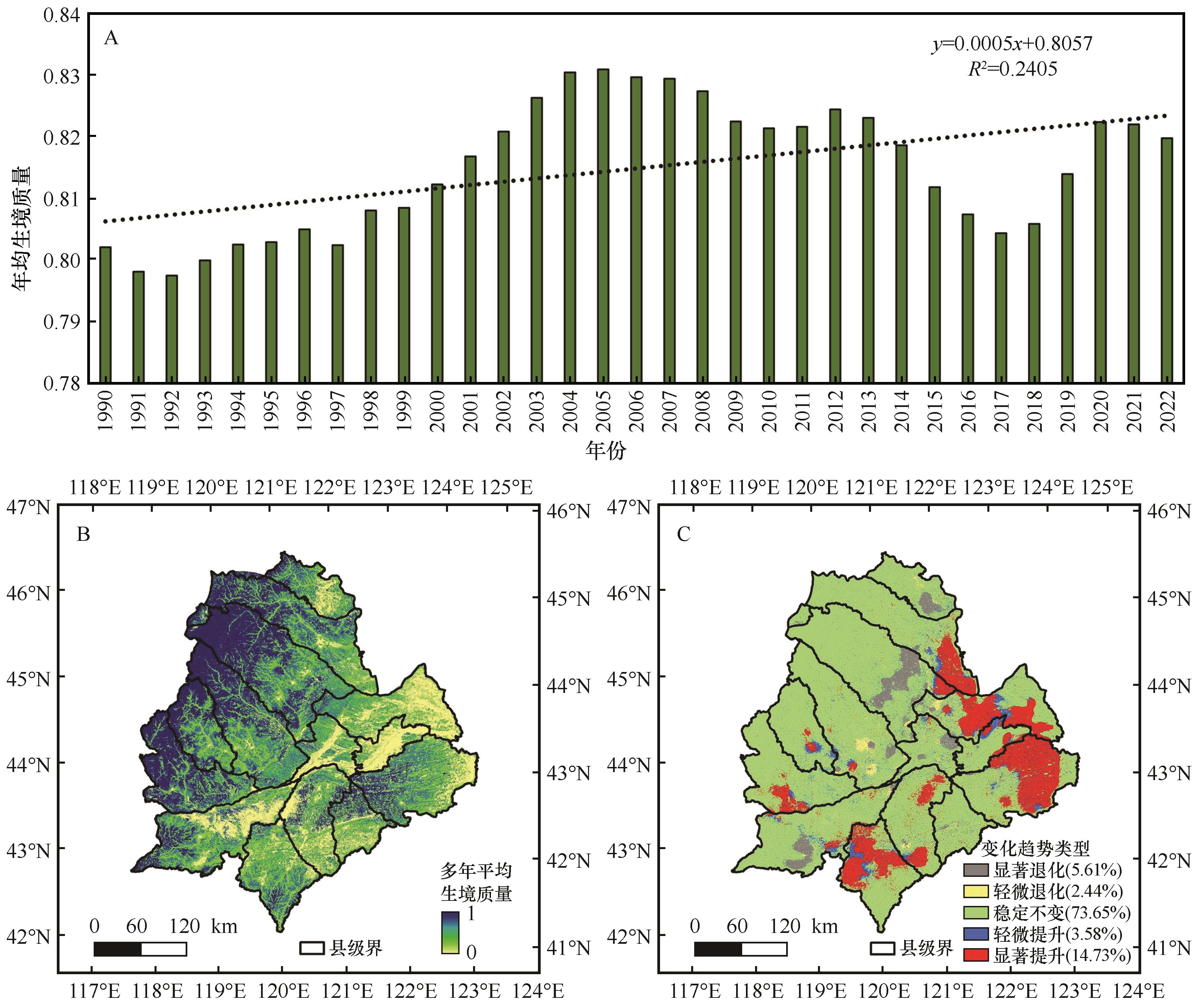
Fig.3 Spatiotemporal evolution of habitat quality in the Horqin Sandy Land from 1990 to 2022
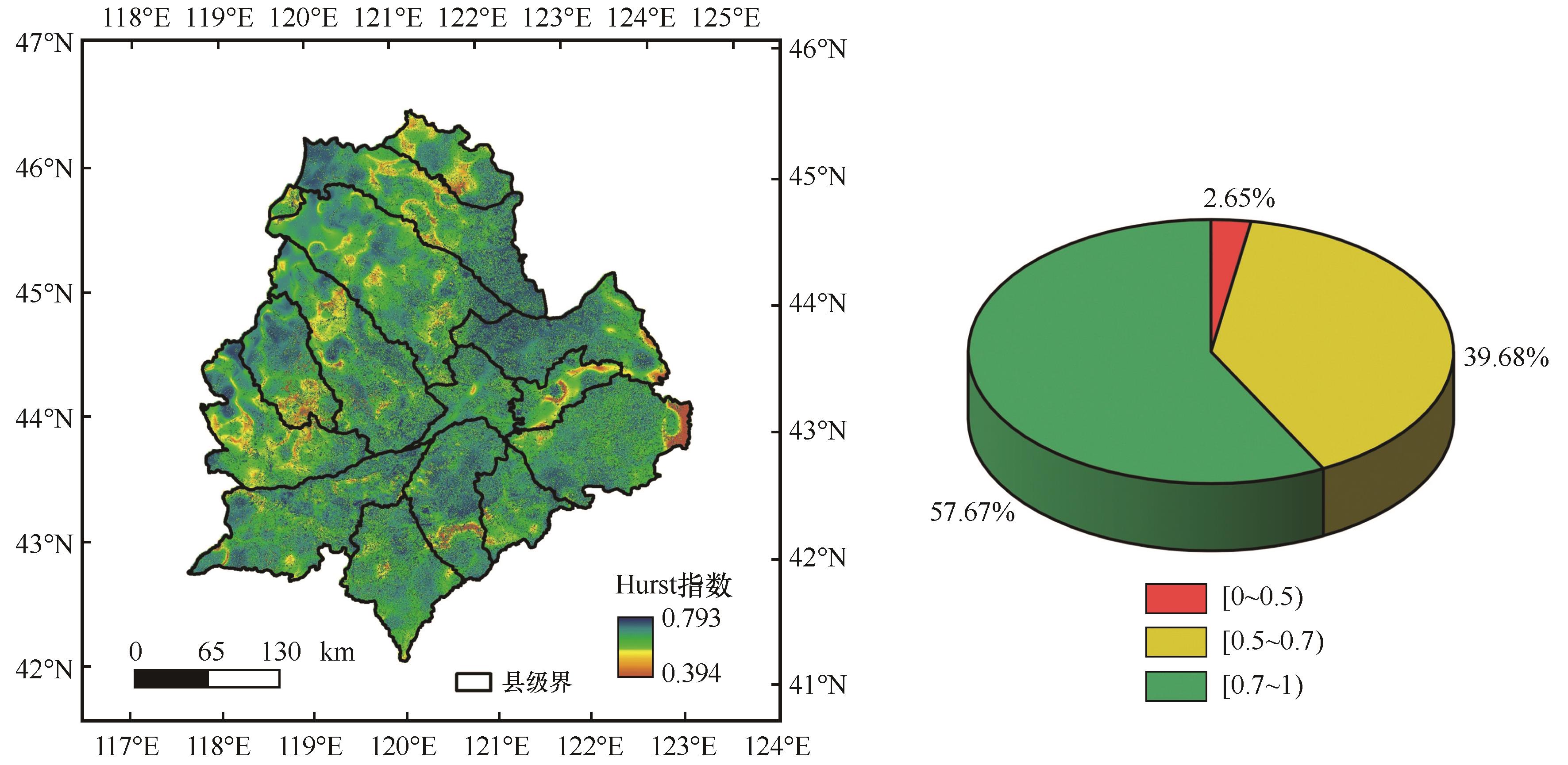
Fig.4 Spatial Distribution of the Hurst Index in the Horqin Sandy Land from 1990 to 2022

Fig.5 Results of Geographic Detector

Fig.6 Land use distribution scenarios in Horqin Sandy Land, 2035
| 土地利用类型 | 2022年/km² | 2035年/km² | |||
|---|---|---|---|---|---|
| 自然发展情景 | 生态优先情景 | 经济优先情景 | 综合发展情景 | ||
| 耕地 | 48 542.94 | 49 426.29 | 46 261.91 | 46 556.50 | 46 191.57 |
| 林地 | 8 285.49 | 8 921.07 | 8 647.25 | 8 285.48 | 8 604.75 |
| 草地 | 61 152.03 | 59 123.7 | 62 405.78 | 62 405.72 | 61 739.07 |
| 水域 | 361.98 | 173.16 | 362.04 | 211.31 | 361.79 |
建设用地 未利用地 | 3 613.32 3 357.63 | 4 347.18 3 319.56 | 3 613.38 4 017.52 | 4 491.26 3 357.62 | 4 455.25 3 954.70 |
Table 10 Land use area of Horqin Sandy Land under different scenarios
| 土地利用类型 | 2022年/km² | 2035年/km² | |||
|---|---|---|---|---|---|
| 自然发展情景 | 生态优先情景 | 经济优先情景 | 综合发展情景 | ||
| 耕地 | 48 542.94 | 49 426.29 | 46 261.91 | 46 556.50 | 46 191.57 |
| 林地 | 8 285.49 | 8 921.07 | 8 647.25 | 8 285.48 | 8 604.75 |
| 草地 | 61 152.03 | 59 123.7 | 62 405.78 | 62 405.72 | 61 739.07 |
| 水域 | 361.98 | 173.16 | 362.04 | 211.31 | 361.79 |
建设用地 未利用地 | 3 613.32 3 357.63 | 4 347.18 3 319.56 | 3 613.38 4 017.52 | 4 491.26 3 357.62 | 4 455.25 3 954.70 |
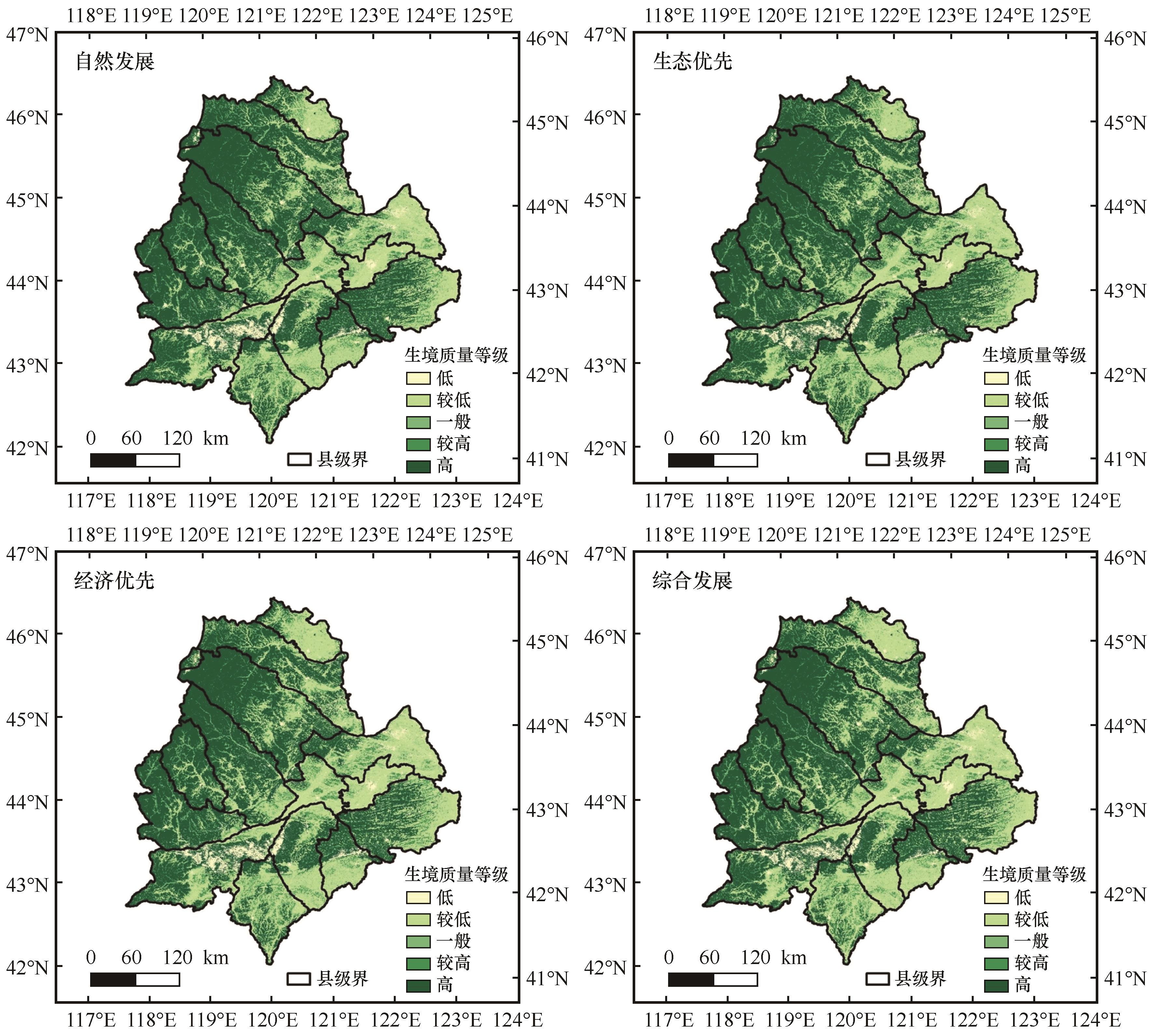
Fig.7 Spatial Distribution of Habitat Predictions in the Horqin Sandy Land Under Different Scenarios for 2035
| 生境质量等级 | 2022年/km² | 2035年/km² | |||
|---|---|---|---|---|---|
| 自然发展情景 | 生态优先情景 | 经济优先情景 | 综合发展情景 | ||
| 低 | 7 525.71 | 6 237.27 | 4 997.97 | 7 045.56 | 7 039.35 |
| 较低 | 39 831.3 | 38 109.33 | 39 229.02 | 42 789.87 | 44 056.71 |
| 一般 | 8 530.65 | 9 477.63 | 9 779.04 | 8 418.42 | 8 401.59 |
| 较高 | 7 078.32 | 6 864.48 | 6 654.51 | 6 894.81 | 7 075.89 |
| 高 | 62 344.98 | 64 622.25 | 64 650.42 | 58 918.5 | 59 981.22 |
Table 11 Habitat quality area under different scenarios in the Horqin Sandy Land
| 生境质量等级 | 2022年/km² | 2035年/km² | |||
|---|---|---|---|---|---|
| 自然发展情景 | 生态优先情景 | 经济优先情景 | 综合发展情景 | ||
| 低 | 7 525.71 | 6 237.27 | 4 997.97 | 7 045.56 | 7 039.35 |
| 较低 | 39 831.3 | 38 109.33 | 39 229.02 | 42 789.87 | 44 056.71 |
| 一般 | 8 530.65 | 9 477.63 | 9 779.04 | 8 418.42 | 8 401.59 |
| 较高 | 7 078.32 | 6 864.48 | 6 654.51 | 6 894.81 | 7 075.89 |
| 高 | 62 344.98 | 64 622.25 | 64 650.42 | 58 918.5 | 59 981.22 |

Fig.8 Shows the changes in land use transfer in the Horqin Sandy Land from 1990 to 2017(unit:km2)
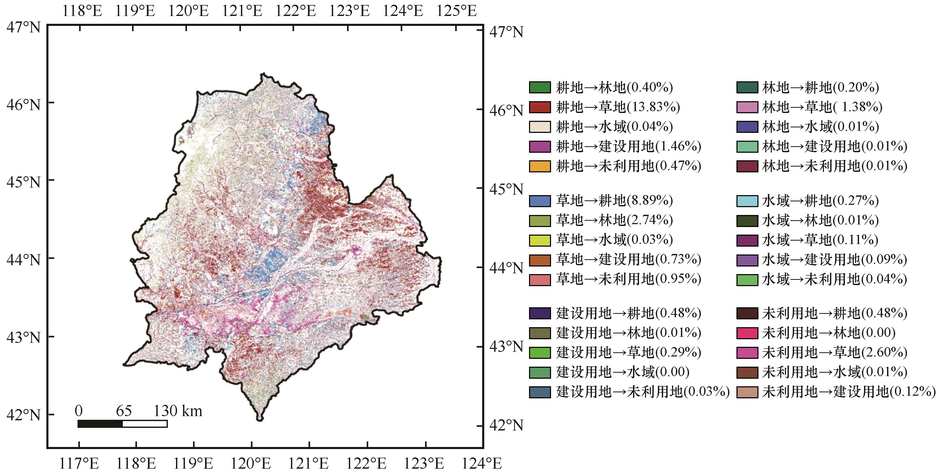
Fig.9 Spatial changes in land use transition characteristics in Horqin (1990-2022)
| [1] | 胡云锋,张云芝,韩月琪.2000-2015年中国荒漠化土地识别和监测[J].干旱区地理,2018,41(6):1321-1332. |
| [2] | Reynolds J F, Smith D M S, Lambin E F,et al.Global desertification:building a science for dryland development[J].Science,2007,316(5826):847-851. |
| [3] | 张铜会,丛安琪,连杰,等.从科尔沁草原到科尔沁沙地的思考[J].应用生态学报,2024,35(1):25-30. |
| [4] | 李玉强,王旭洋,郑成卓,等.科尔沁沙地防沙治沙实践与生态可持续修复浅议[J].中国沙漠,2024,44(4):302-314. |
| [5] | 王康富,蒋瑾,张维静.京通铁路两侧防护体系的建立及其生态效益的研究:以奈曼地段为例[J].中国沙漠,1989,9(3):4-15. |
| [6] | 张晓明.三北防护林工程建设成效及发展对策[J].防护林科技,2020(2):52-54. |
| [7] | 刘峰,杨光,韩雪莹,等.科尔沁沙地土地利用时空演变及空间自相关分析:以奈曼旗为例[J].西北林学院学报,2020,35(4):148-157. |
| [8] | 王涛,宋翔,颜长珍,等.近35 a来中国北方土地沙漠化趋势的遥感分析[J].中国沙漠,2011,31(6):1351-1356. |
| [9] | 张寒冰,高阳,崔艳智.基于风沙防治的典型农牧交错区土地利用多情景模拟[J].环境科学研究,2019,32(6):1081-1089. |
| [10] | 张文昭.科尔沁、浑善达克两大沙地歼灭战稳步推进[J].国土绿化,2024(2):17-18. |
| [11] | 邵国媚,乔琴,张文婷,等.科尔沁草原生态功能区防风固沙功能时空变化及驱动因素分析[J].环境科学研究,2025,38(1):139-150. |
| [12] | 叶博文,孙标,赵云靓,等.2000-2022年内蒙古生境质量时空演变及驱动力分析[J].环境科学,2025,46(7):4473-4484. |
| [13] | Ma R, Lü Y, Fu B,et al.A modified habitat quality model to incorporate the effects of ecological restoration[J].Environmental Research Letters,2022,17(10):104029. |
| [14] | 印家旺,阿拉木萨,苏宇航,等.科尔沁沙地不同土地利用类型土壤入渗特征比较研究[J].水土保持通报,2022,42(4):90-98. |
| [15] | 杨志鹏,许嘉巍,冯兴华,等.基于InVEST模型的东北地区土地利用变化对生境的影响研究[J].生态科学,2018,37(6):139-147. |
| [16] | Yang J, Huang X.The 30 m annual land cover dataset and its dynamics in China from 1990 to 2019[J].Earth System Science Data,2021,13(8):3907-3925. |
| [17] | Wang M, Guan Q.Prediction of potential suitable areas for Broussonetia papyrifera in China using the MaxEnt model and CIMP6 data[J].Journal of Plant Ecology,2023,16(4):rtad006. |
| [18] | Boumans R, Costanza R, Farley J,et al.Modeling the dynamics of the integrated earth system and the value of global ecosystem services using the GUMBO model[J].Ecological Economics,2002,41(3):529-560. |
| [19] | 高周冰,王晓瑞,隋雪艳,等.基于FLUS和InVEST模型的南京市生境质量多情景预测[J].农业资源与环境学报,2022,39(5):1001-1013. |
| [20] | 王成武,罗俊杰,唐鸿湖.基于InVEST模型的太行山沿线地区生态系统碳储量时空分异驱动力分析[J].生态环境学报,2023,32(2):215-225. |
| [21] | Wei Q, Abudureheman M, Halike A,et al.Temporal and spatial variation analysis of habitat quality on the PLUS-InVEST model for Ebinur Lake Basin,China[J].Ecological Indicators,2022,145:109632. |
| [22] | Jiang W, Deng Y, Tang Z,et al.Modelling the potential impacts of urban ecosystem changes on carbon storage under different scenarios by linking the CLUE-S and the InVEST models[J].Ecological Modelling,2017,345:30-40. |
| [23] | 周豹,赵俊三,陈国平,等.多情景模拟下滇东南喀斯特地区生态系统服务评估与网络优化[J].环境科学,2025,46(7):4615-4627. |
| [24] | 王军,严有龙,王金满,等.闽江流域生境质量时空演变特征与预测研究[J].生态学报,2021,41(14):5837-5848. |
| [25] | 顾汉龙,马天骏,钱凤魁,等.基于CLUE-S模型县域土地利用情景模拟与碳排放效应分析[J].农业工程学报,2022,38(9):288-296. |
| [26] | Zhang Y, Yu P, Tian Y,et al.Exploring the impact of integrated spatial function zones on land use dynamics and ecosystem services trade-offs based on a future land use simulation (FLUS) model[J].Ecological Indicators,2023,150:110246. |
| [27] | 胡碧松,张涵玥.基于CA-Markov模型的鄱阳湖区土地利用变化模拟研究[J].长江流域资源与环境,2018,27(6):1207-1219. |
| [28] | 智菲,周振宏,赵铭,等.基于PLUS和InVEST模型的合肥市生态系统碳储量时空演变特征[J].水土保持学报,2024,38(2):205-215. |
| [29] | 黄韬,刘素红.基于PLUS-InVEST模型的福建省土地利用变化与碳储量评估[J].水土保持学报,2024,38(2):246-257. |
| [30] | Liu X, Liu Y, Wang Y,et al.Evaluating potential impacts of land use changes on water supply-demand under multiple development scenarios in a dryland region[J].Journal of Hydrology,2022,610:127811. |
| [31] | Wang R, Zhao J, Chen G,et al.Coupling PLUS-InVEST model for ecosystem service research in Yunnan Province,China[J].Sustainability,2022,15(1):271. |
| [32] | 陈清飞,陈安强,叶远行,等.滇池流域土地利用变化对地下水水质的影响[J].中国环境科学,2023,43(1):301-310. |
| [33] | 张波,潘佩佩,王新云,等.基于GMOP-PLUS耦合模型的京津冀土地利用变化多情景模拟及功能关系分析[J].地理与地理信息科学,2023,39(5):8-16. |
| [34] | 胡波洋,张蓬涛,白宁,等.基于CLUE-S和GMOP模型的青龙满族自治县土地利用情景模拟[J].中国农业资源与区划,2020,41(7):173-182. |
| [35] | 马瑞,范燕敏,武红旗,等.耦合GMOP与PLUS模型的干旱区土地利用格局模拟[J].农业资源与环境学报,2023,40(1):143-153. |
| [36] | 许静,刘慧.甘肃省生态系统服务权衡协同关系评估与预测[J].中国环境科学,2024,44(4):1863-1874. |
| [37] | 中共中央,国务院.关于全面推进美丽中国建设的意见[N].人民日报,2024-01-12(1). |
| [38] | 苏立娟,李喜仓,邓晓东.1951-2005年内蒙古东部气候变化特征分析[J].气象与环境学报,2008,24(5):25-28. |
| [39] | 王妍力,王永芳,郭恩亮,等.科尔沁沙地生态安全格局时空演变规律研究[J].地理科学,2025,45(6):1341-1354. |
| [40] | Xue C, Chen X, Xue L,et al.Modeling the spatially heterogeneous relationships between trade-offs and synergies among ecosystem services and potential drivers considering geographic scale in Bairin Left Banner,China[J].Science of the Total Environment,2023,855:158834. |
| [41] | 陈实,金云翔,黄银兰.长三角中心区生境质量时空变化及其影响机制[J].生态学杂志,2023,42(5):1175-1185. |
| [42] | 胡丰,张艳,郭宇,等.基于PLUS和InVEST模型的渭河流域土地利用与生境质量时空变化及预测[J].干旱区地理,2022,45(4):1125-1136. |
| [43] | Wang J F, Hu Y.Environmental health risk detection with GeogDetector[J].Environmental Modelling and Software,2012,33:114-115. |
| [44] | Yan X, Li J, Shao Y,et al.Driving forces of grassland vegetation changes in Chen Barag Banner,Inner Mongolia[J].GIScience & Remote Sensing,2020,57(6):753-769. |
| [45] | Wang F, Shao W, Yu H,et al.Re-evaluation of the power of the Mann-Kendall test for detecting monotonic trends in hydrometeorological time series[J].Frontiers in Earth Science,2020,8:14. |
| [46] | Zhang H, Song J, Wang G,et al.Spatiotemporal characteristic and forecast of drought in Northern Xinjiang,China[J].Ecological Indicators,2021,127:107712. |
| [47] | Jia Z, Wang X, Feng X,et al.Exploring the spatial heterogeneity of ecosystem services and influencing factors on the Qinghai-Tibet Plateau[J].Ecological Indicators,2023,154:110521. |
| [48] | 张春悦,白永平,杨雪荻,等.多情景模拟下宁夏平原生态系统服务簇识别研究[J].地理研究,2022,41(12):3364-3382. |
| [49] | 全江涛,杨永芳,周嘉昕.河南省土地资源承载力时空演变分析与预测[J].水土保持研究,2020,27(2):315-322. |
| [50] | 谢高地,张彩霞,张雷明,等.基于单位面积价值当量因子的生态系统服务价值化方法改进[J].自然资源学报,2015,30(8):1243-1254. |
| [51] | Zhu W, Gao Y, Zhang H,et al.Optimization of the land use pattern in Horqin Sandy Land by using the CLUMondo model and Bayesian belief network[J].Science of the Total Environment,2020,739:139929. |
| [52] | Xia H, Kong W, Zhou G,et al.Impacts of landscape patterns on water-related ecosystem services under natural restoration in Liaohe River Reserve,China[J].Science of the Total Environment,2021,792:148290. |
| [53] | Hu Y, Gong J, Li X,et al.Ecological security assessment and ecological management zoning based on ecosystem services in the West Liao River Basin[J].Ecological Engineering,2023,192:106973. |
| [54] | 刘志民,余海滨.“山水林田湖草沙生命共同体”理念下的科尔沁沙地生态治理[J].中国沙漠,2022,42(1):34-40. |
| [55] | Fan J, Xu Y, Ge H,et al.Vegetation growth variation in relation to topography in Horqin Sandy Land[J].Ecological Indicators,2020,113:106215. |
| [56] | 王彦颖.中国东北植被时空动态变化及其对气候响应研究[D].长春:东北师范大学,2016. |
| [57] | 肖巍.科尔沁沙地南缘退化耕地风沙危害状况[J].江西农业,2019(12):84. |
| [58] | 马浩文,王永芳,郭恩亮.基于GEE的翁牛特旗土地沙漠化遥感监测[J].干旱区研究,2023,40(3):504-516. |
| [59] | 朱梦媛,田一辰,金磊,等.科尔沁沙地南缘生态屏障区防风固沙功能时空变化及其影响因素[J].生态学杂志,2025,44(6):1857-1865. |
| [60] | Pan Z, Gao G, Fu B,et al.Exploring the historical and future spatial interaction relationship between urbanization and ecosystem services in the Yangtze River Basin,China[J].Journal of Cleaner Production,2023,428:139401. |
| [1] | Bo Yao, Jie Lian, Xiangwen Gong, Xiaoming Mou, Yulin Li, Yuqiang Li, Xuyang Wang. Spatial patterns and influencing factors of soil microbial carbon, nitrogen and phosphorus stoichiometry in Horqin Sandy Land [J]. Journal of Desert Research, 2025, 45(4): 153-165. |
| [2] | Jianpeng Zhang, Luming Lei, Yuqiang Li, Tianai Li, Xueyong Zhao, Haotong Ren, Hong Jia, Yangyang Wang, Lihan Cui. Sustainability assessment of human-earth systems from ecosystem service supply-demand perspectives: evidence from Horqin Sandy Land, China [J]. Journal of Desert Research, 2025, 45(4): 176-189. |
| [3] | Zhiying Ning, Yulin Li, Xueyong Zhao, Yanjun Zhang, Haibing Wang, Min Yan, Ruimin Liu, Heju Zuo. Effects litter decomposition characteristics of dominant plants on soil microbial community in Horqin Sandy Land [J]. Journal of Desert Research, 2025, 45(4): 190-199. |
| [4] | Hong Jia, Jianpeng Zhang, Lianyou Liu, Jifu Liu, Siqi Yang. Variation and multi-scenario simulation of habitat quality in the Gonghe Basin, China [J]. Journal of Desert Research, 2025, 45(2): 29-36. |
| [5] | gaowa Saren, Yuanyuan Zhao, Xinzhi Geng, Yue Wang, Guanglei Gao. Sustainability assessment of the human-earth system in the sandy areas of Inner Mongolia from 2000 to 2020 [J]. Journal of Desert Research, 2025, 45(2): 71-82. |
| [6] | Honghua Xia, Linshan Yang, Qi Feng, Yingqing Su, Xingyi Zou, Wanghan He. Spatio-temporal variation and driving factors of water supply and demand in Shiyang River Basin [J]. Journal of Desert Research, 2024, 44(6): 87-99. |
| [7] | Jing Zhang, Xiaoan Zuo, Peng Lv. Effects of changes in growing season precipitation regimes on plant community structure, function and aboveground biomass in typical habitats in the Horqin Sandy Land [J]. Journal of Desert Research, 2024, 44(4): 1-13. |
| [8] | Hanchen Duan, Beiying Huang. Comprehensive evaluation of land desertification sensitivity in the Horqin Sandy Land based on the coupling of AHP and improved MEDALUS model [J]. Journal of Desert Research, 2024, 44(4): 137-148. |
| [9] | Eryan Liu, Yuanyuan Zhao, Die Zhou, Haiyan Wu, Guanglei Gao, Guodong Ding. Spatiotemporal variation patterns of land desertification from 2000 to 2020 in the Horqin-Otindag Sandy Land [J]. Journal of Desert Research, 2024, 44(4): 46-56. |
| [10] | Xiaoyu Han, Yunping Chi, Yuanyun Xie, Chunguo Kang, Peng Wu, Yehui Wang, Lei Sun, Zhengyu Wei. Material composition characteristics of fine particles of eolian sand in Horqin Sandy Land and its indication to provenance [J]. Journal of Desert Research, 2024, 44(3): 231-246. |
| [11] | Xiaoyu Zhang, Zixiang Zhou, Zhixiong Tang, Yanxu Sun. Spatio-temporal variation and prediction of habitat quality in Wuding River Basin [J]. Journal of Desert Research, 2024, 44(3): 75-84. |
| [12] | Tianling Bao, Jiliang Liu, Feng Yuan, Yinlong Li, Zhenyu Jia, Chengchen Pan. Response of plant community to experimental warming in Horqin Sandy Land [J]. Journal of Desert Research, 2024, 44(1): 151-160. |
| [13] | Chengwei Zheng, Xiaohong Deng, Zongxing Li, Jian Xue, Libang Ma, Juan He, Shuxiang Lu, Jianxiong Shao, Shiyu Cai, Peiyi Zhao. Analysis of the spatial and temporal evolution of water resources conservation and human activity intensity in the Hexi region of Gansu Province [J]. Journal of Desert Research, 2024, 44(1): 189-200. |
| [14] | Yu Ren, Bo Zhang, Xidong Chen. Desertification sensitivity assessment in Horqin Sandy Land [J]. Journal of Desert Research, 2023, 43(2): 159-169. |
| [15] | Meng Yan, Xuyang Wang, Liye Zhou, Yuqiang Li. Characteristics and influencing factors of soil organic carbon in the process of desertification in Horqin Sandy Land [J]. Journal of Desert Research, 2022, 42(5): 221-231. |
| Viewed | ||||||
|
Full text |
|
|||||
|
Abstract |
|
|||||
©2018Journal of Desert Research
Tel:0931-8267545
Email:caiedit@lzb.ac.cn;desert@lzb.ac.cn
Support:Magtech