| 1 |
张强.华北地区干旱指数的确定及其应用[J].灾害学,1998,13(4):34-38.
|
| 2 |
黄会平.1949-2007全国干旱灾害特征、成因及减灾对策[J].干旱区资源与环境,2010,24(11):94-98.
|
| 3 |
王素萍,李耀辉,冯建英,等.1961-2012年甘肃省干湿变化特征及其影响因子[J].中国沙漠,2014,34(6):1624-1632.
|
| 4 |
王莺,李耀辉,胡田田.基于SPI指数的甘肃省河东地区干旱时空特征分析[J].中国沙漠,2014,34(1):244-253.
|
| 5 |
柏庆顺,颜鹏程,蔡迪花,等.近56 a中国西北地区不同强度干旱的年代际变化特征[J].干旱气象,2019,37(5):722-728.
|
| 6 |
马鹏里,韩兰英,张旭东,等.气候变暖背景下中国干旱变化的区域特征[J].中国沙漠,2019,39(6):209-215.
|
| 7 |
Wu H,Hayes M J,Wilhite D A,et al.The effect of the length of record on the standardized precipitation index calculation[J].International Journal of Climatology,2005,25(4):505-520.
|
| 8 |
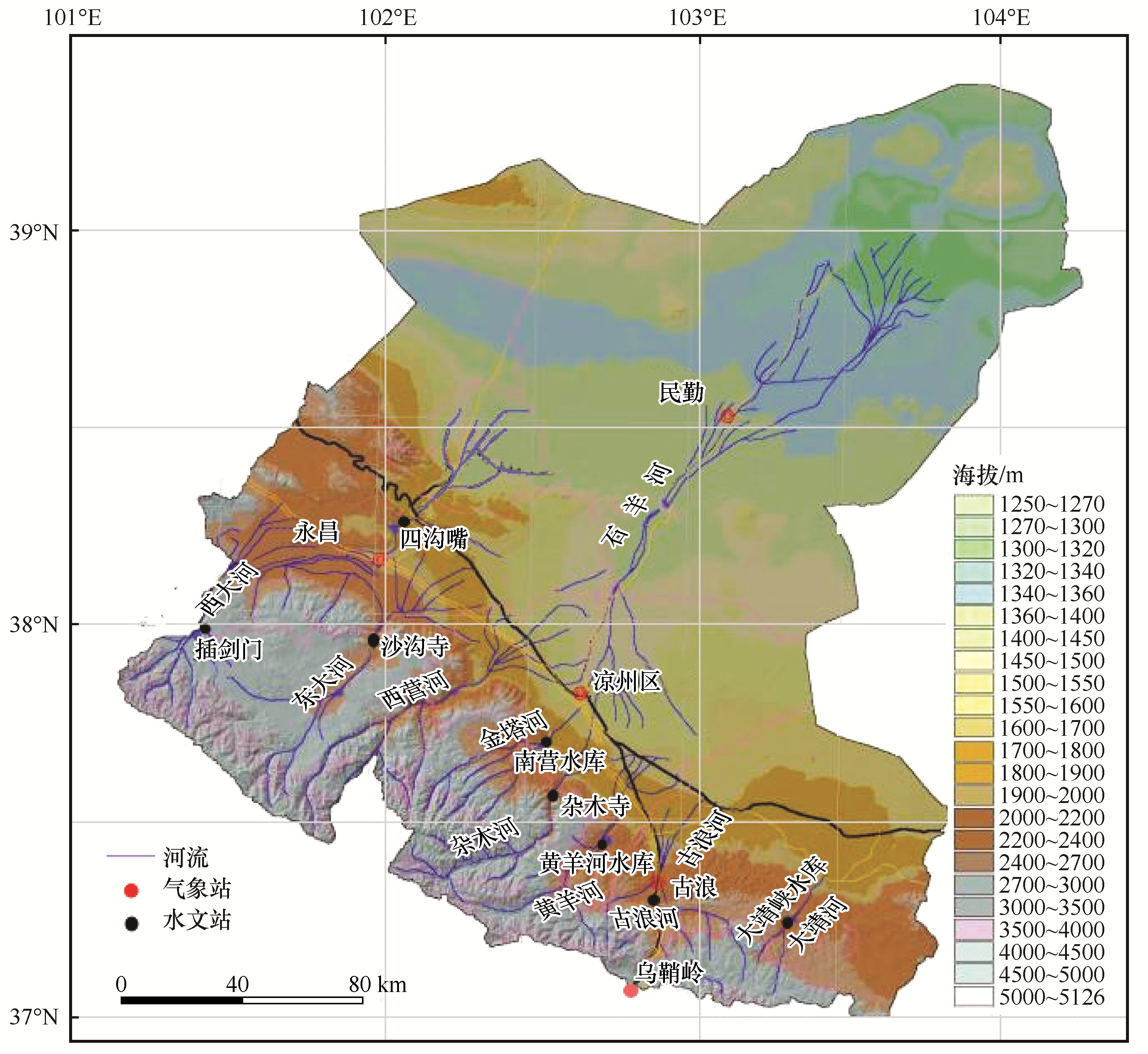
Wu H,Svoboda M D,Hayes M J,et al.Appropriate application of the standardized precipitation index in arid locations and dry seasons[J].International Journal of Climatology,2007,27(1):65-79.
|
| 9 |
Bai Y,Xu H,Ling H.Drought-flood variation and its correlation with runoff in there headstreams of Tarim River,Xinjiang,China[J].Environmental Earth Sciences,2014,71(3):1297-1309.
|
| 10 |
Yan D H,Han D M,Wang G,et al.The evolution analysis of flood and drought in Huai River Basin of China based on monthly precipitation characteristics[J].Natural Hazards,2014,73(2):849-858.
|
| 11 |
王芝兰,王劲松,李耀辉,等.标准化降水指数与广义极值分布干旱指数在西北地区应用的对比分析[J].高原气象,2013,32(3):839-847.
|
| 12 |
韩兰英,张强,赵红岩,等.甘肃省农业干旱灾害损失特征及其对气候变暖的响应[J].中国沙漠,2016,36(3):767-776.
|
| 13 |
王劲松,李耀辉,王润元,等.中国气象干旱研究进展评述[J].干旱气象,2012,26(6):3-7.
|
| 14 |
Heim J,Richard R.A review of twentieth-century drought indices used in the United States[J].Bulletin of the American Meteorological Society,2002,83(8):1149-1165.
|
| 15 |
Wilhite D A,Glantz M H.Understanding the drought phenomenon:the role of definitions[J].Water International,1985,10(3) :111-120.
|
| 16 |
韩兰英,张强,贾建英,等.气候变暖背景下中国干旱强度、频次和持续时间及其南北差异性[J].中国沙漠,2019,39(5):1-10.
|
| 17 |
刘宪锋,朱秀芳,潘耀忠,等.农业干旱监测研究进展与展望[J].地理学报,2015,70(11):1835-1848.
|
| 18 |
Van Loon A F,Laaha G.Hydrological drought severity explained by climate and catchment characteristics[J].Journal of Hydrology,2015,526(7):3-14.
|
| 19 |
Wu J,Chen X,Yao H,et al.Non-linear relationship of hydrological drought responding to meteorological drought and impact of a large reservoir[J].Journal of Hydrology,2017,551(8):495-507.
|
| 20 |
董前进,谢平.水文干旱研究进展[J].水文,2014,34(4):1-7.
|
| 21 |
和宛琳,徐宗学.渭河流域干旱特征及干旱指数计算方法初探[J].气象,2006,32(1):24-29.
|
| 22 |
李丽丽,王大为,韩涛.2000-2015年石羊河流域植被覆盖度及其对气候变化的响应[J].中国沙漠,2018,38(5):1108-1118.
|
| 23 |
王遵娅,丁一汇,何金海,等.近50年来中国气候变化特征的再分析[J].气象学报,2004,62(2):228-236.
|
| 24 |
冯建英,李栋梁.甘肃省河西内陆河流量长期变化特征[J].气候与环境研究,2001,6(4):478-484.
|
| 25 |
李玲萍,刘明春.石羊河流域出山口河流流量的变化趋势及特性分析[J].水土保持学报,2011,27(1):58-63.
|
| 26 |
刘明春,李玲萍,史志娟,等.石羊河流域径流量分布特征及对气候变化的响应:以西营河为例[J].干旱地区农业研究,2013,31(1):193-198.
|
| 27 |
王劲松,冯建英.甘肃省河西地区径流量干旱指数初探[J].气象,2000,26(6):3-7.
|
| 28 |
Husak G J,Michaelsen J,Funk C.Use of the gamma distribution to represent monthly rainfall in Africa for drought monitoring applications[J].International Journal of Climatology,2007,27(7) :935-944.
|
| 29 |
王亚文.变化环境下无定河流域水文干旱演变规律及驱动机制分析[D].陕西杨凌:西北农林科技大学,2017.
|
| 30 |
段洪玲.关于游程分布的一些研究及应用[D].沈阳:东北大学,2006.
|
| 31 |
Hassan I H,Mdemu M V,Shemdoe R S,et al.Drought pattern along the coastal forest zone of Tanzania[J].Atmospheric and Climate Sciences,2014,4(3):369-384.
|
| 32 |
Mishra A K,Singh V P.A review of drought concepts[J].Journal of Hydrology,2010,391(1):202-216.
|
| 33 |
Hirabayashi Y,Kanae S,Emori S,et al.Global projections of changing risks of floods and droughts in a changing climate[J].Hydrological Sciences Journal-Journal Des Sciences Hydrologiques,2008,53(4):754-772.
|
| 34 |
贾文雄,何元庆,李宗省,等.祁连山及河西走廊地表干湿变化的时空分布[J].地球科学,2010,35(2):268-276.
|
 ), 卢泰山3(
 甘公网安备 62010202000688号