中国沙漠 ›› 2021, Vol. 41 ›› Issue (6): 88-98.DOI: 10.7522/j.issn.1000-694X.2021.00090
杨旭艳1( ), 董治宝2(), 杨勤科1(), 李超2
收稿日期:2021-05-06
修回日期:2021-07-19
出版日期:2021-11-20
发布日期:2021-12-17
通讯作者:
董治宝,杨勤科
作者简介:杨勤科(E-mail: qkyang@nwu.edu.cn)
Xuyan Yang1(), Zhibao Dong2(), Qinke Yang1(), Chao Li2
Received:2021-05-06
Revised:2021-07-19
Online:2021-11-20
Published:2021-12-17
Contact:
Zhibao Dong,Qinke Yang
摘要:
沙丘是柴达木盆地可类比火星的重要地貌类型,沙丘形态是类火星风沙地貌研究的重要内容。基于数字地形分析(DTA)的方法,采用高程、坡度、坡向及地表复杂程度4个地形计量学指标对火星(北极地区)和地球(柴达木盆地)格状沙丘的地貌形态特征进行定量对比分析。结果表明:(1)两个研究区的高程剖面、坡度、坡向的地理学空间分布格局具有较大相似性;(2)高程、高程梯度、坡度和坡向的直方图相似度指数均大于0.7;(3)不同尺度上的分形维数近似相等,即地表复杂程度相似。用数字地形分析与直方图相似度指数结合的方法,定量或半定量地分析两个研究区沙丘地貌形态的相似性,这对类火星风沙地貌研究中科学选择试验点是一种新的尝试,以期为反演火星风沙地貌的形成与演化提供科学依据。
中图分类号:
杨旭艳, 董治宝, 杨勤科, 李超. 基于DEM的地球与火星格状沙丘对比分析[J]. 中国沙漠, 2021, 41(6): 88-98.
Xuyan Yang, Zhibao Dong, Qinke Yang, Chao Li. Comparison of networked dunes in the Earth and the Mars based on DEM[J]. Journal of Desert Research, 2021, 41(6): 88-98.
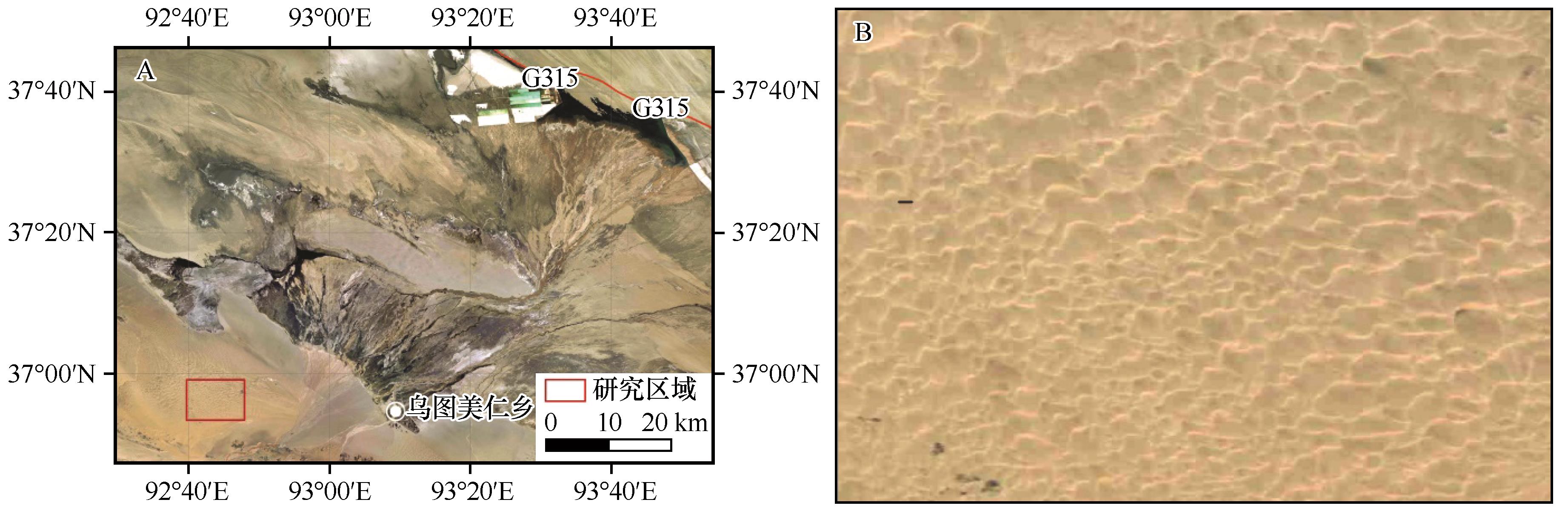
图1 柴达木盆地研究区位置示意图(A)及研究区沙丘放大图(B)A、B图影像、注记等数据来自91卫图,影像空间分辨率为15 m
Fig.1 The location of the studied site in the Qaidam Basin (A) and enlargement of studied site (B)
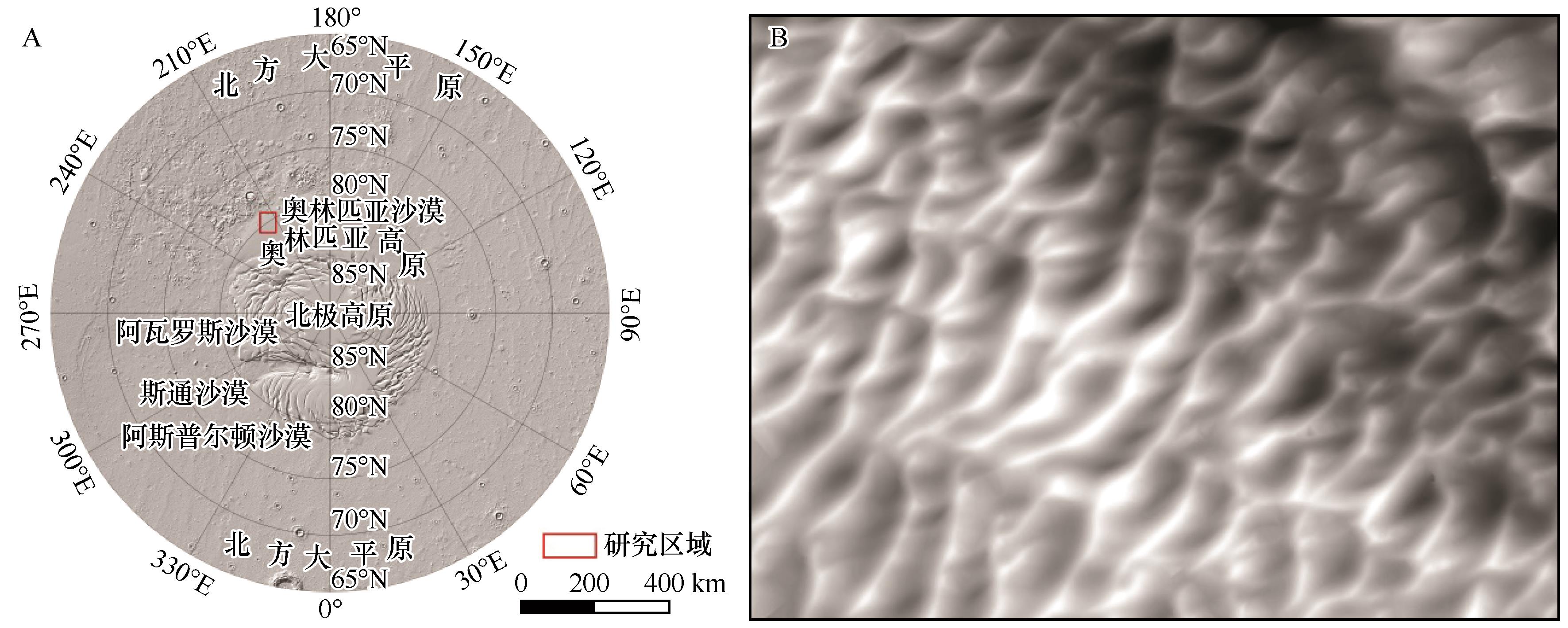
图2 火星研究区位置示意图(A)及研究区沙丘放大图(B)A图DEM数据来自USGS(https://astrogeology.usgs.gov/),空间分辨率463 m;注记来自《火星风沙地貌图》[35]。B图格状沙丘放大图DEM数据来自华盛顿大学行星数据系统(Planetary Data System, PDS)地学数据节点(https://ode.rsl.wustl.edu/mars/index.aspx),空间分辨率1 m
Fig.2 The location of the studied site in the Mars (A) and enlargement of studied site (B)
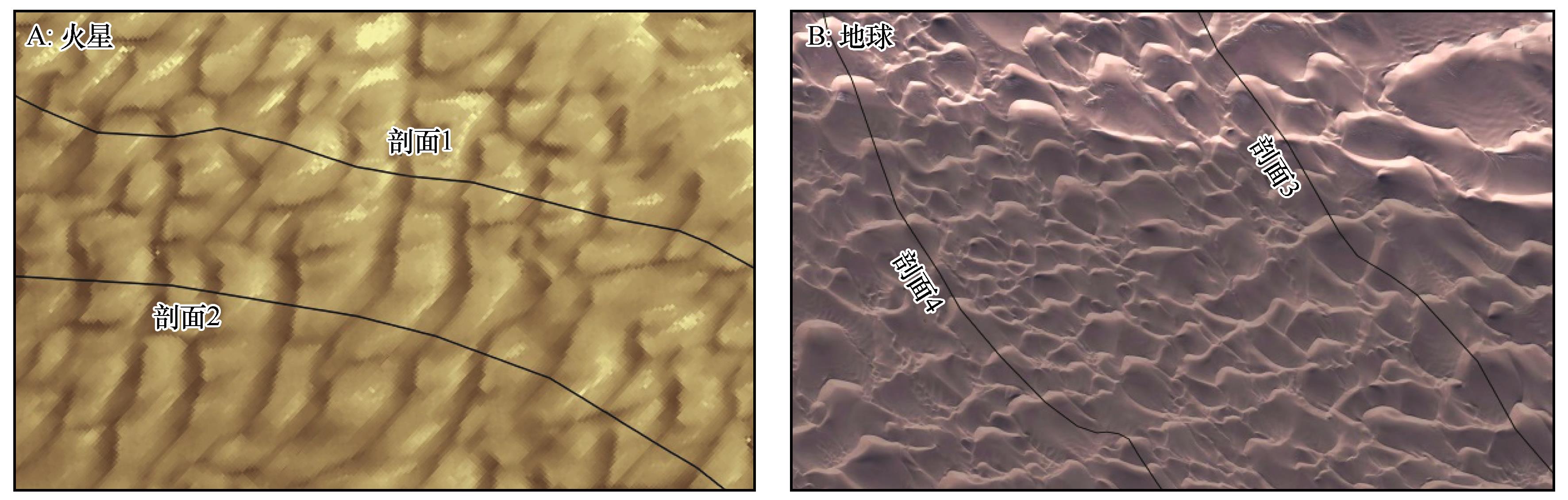
图3 研究区剖面线布设
Fig.3 The distribution of profile lines of studied sites on the Mars (A) and Earth (B)
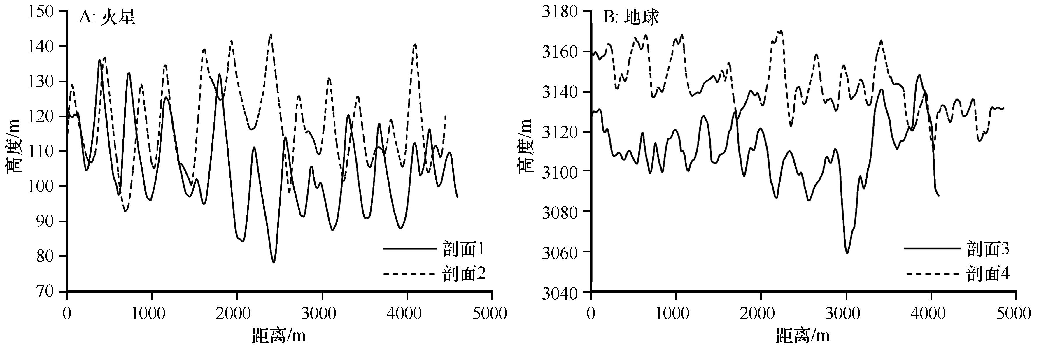
图4 研究区高程剖面曲线图
Fig.4 Elevation profile of studied sites on the Mars (A) and Earth (B)
| 特征值 | 相对高度 | 宽度 | |||||
|---|---|---|---|---|---|---|---|
| 火星 | 地球 | 火星/地球 | 火星 | 地球 | 火星/地球 | ||
| 最小值 | 13.15 | 9.75 | 1.35 | 169.97 | 147.99 | 1.15 | |
| 最大值 | 47.87 | 52.07 | 0.92 | 464.46 | 534.48 | 0.87 | |
| 均值 | 27.73 | 25.03 | 1.11 | 352.05 | 322.12 | 1.09 | |
| 标准差 | 8.92 | 9.94 | 0.90 | 72.46 | 101.26 | 0.72 | |
| 变异系数 | 0.32 | 0.39 | 0.82 | 0.21 | 0.31 | 0.67 | |
表1 研究区格状沙丘形态参数表 (m)
Table 1 The dune networks geomorphology parameters of studied sites
| 特征值 | 相对高度 | 宽度 | |||||
|---|---|---|---|---|---|---|---|
| 火星 | 地球 | 火星/地球 | 火星 | 地球 | 火星/地球 | ||
| 最小值 | 13.15 | 9.75 | 1.35 | 169.97 | 147.99 | 1.15 | |
| 最大值 | 47.87 | 52.07 | 0.92 | 464.46 | 534.48 | 0.87 | |
| 均值 | 27.73 | 25.03 | 1.11 | 352.05 | 322.12 | 1.09 | |
| 标准差 | 8.92 | 9.94 | 0.90 | 72.46 | 101.26 | 0.72 | |
| 变异系数 | 0.32 | 0.39 | 0.82 | 0.21 | 0.31 | 0.67 | |
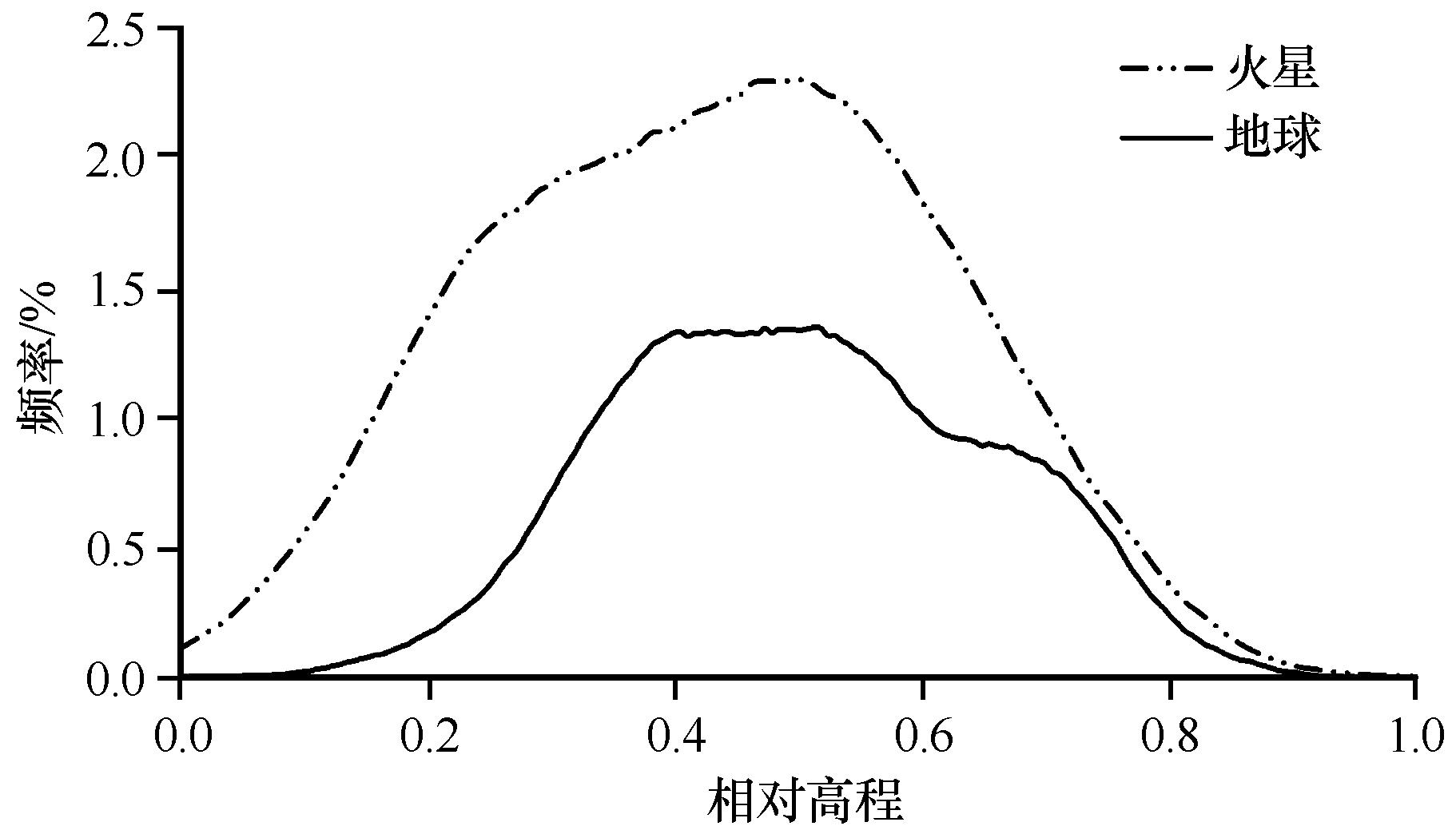
图5 高程频率
Fig.5 Elevation statistical histogram
| 研究区 | 特征值 | |||||
|---|---|---|---|---|---|---|
| 最小值 | 最大值 | 均值 | 标准差 | 众数 | 中位数 | |
| 火星 | 69 | 140 | 107 | 15.47 | 112 | 105.48 |
| 地球 | 3 036 | 3 207 | 3 129.18 | 26.60 | 3 128 | 3 128 |
表2 格状沙丘高程统计 (m)
Table 2 Elevation statistical characteristics of dune networks
| 研究区 | 特征值 | |||||
|---|---|---|---|---|---|---|
| 最小值 | 最大值 | 均值 | 标准差 | 众数 | 中位数 | |
| 火星 | 69 | 140 | 107 | 15.47 | 112 | 105.48 |
| 地球 | 3 036 | 3 207 | 3 129.18 | 26.60 | 3 128 | 3 128 |
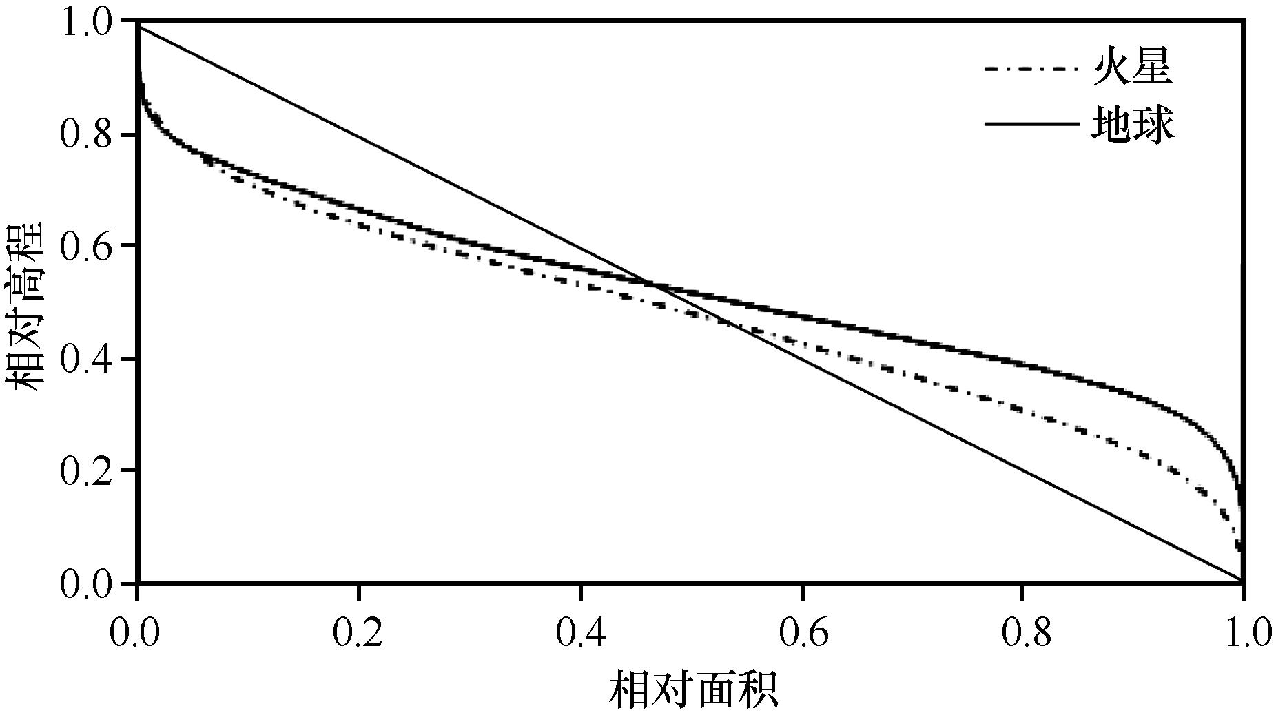
图6 面积-高程积分曲线
Fig.6 Area-Hypsometric Integral curve

图7 研究区高程梯度频率
Fig.7 Elevation gradient histogram of studied sites
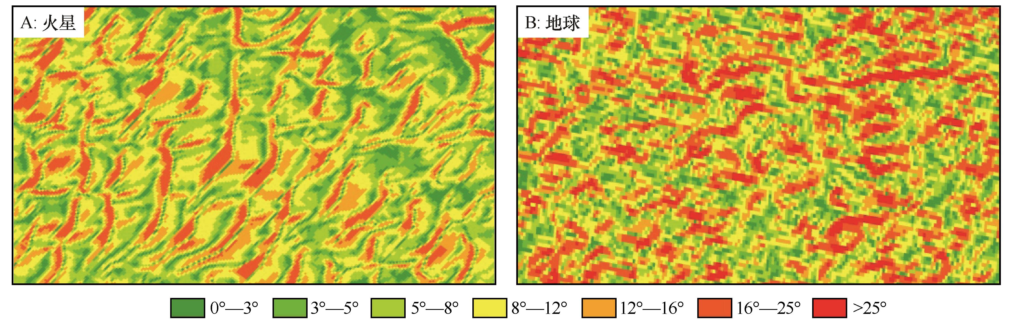
图8 研究区格状沙丘坡度图
Fig.8 Slope map of dune networks of studied sites on the Mars (A) and Earth (B)
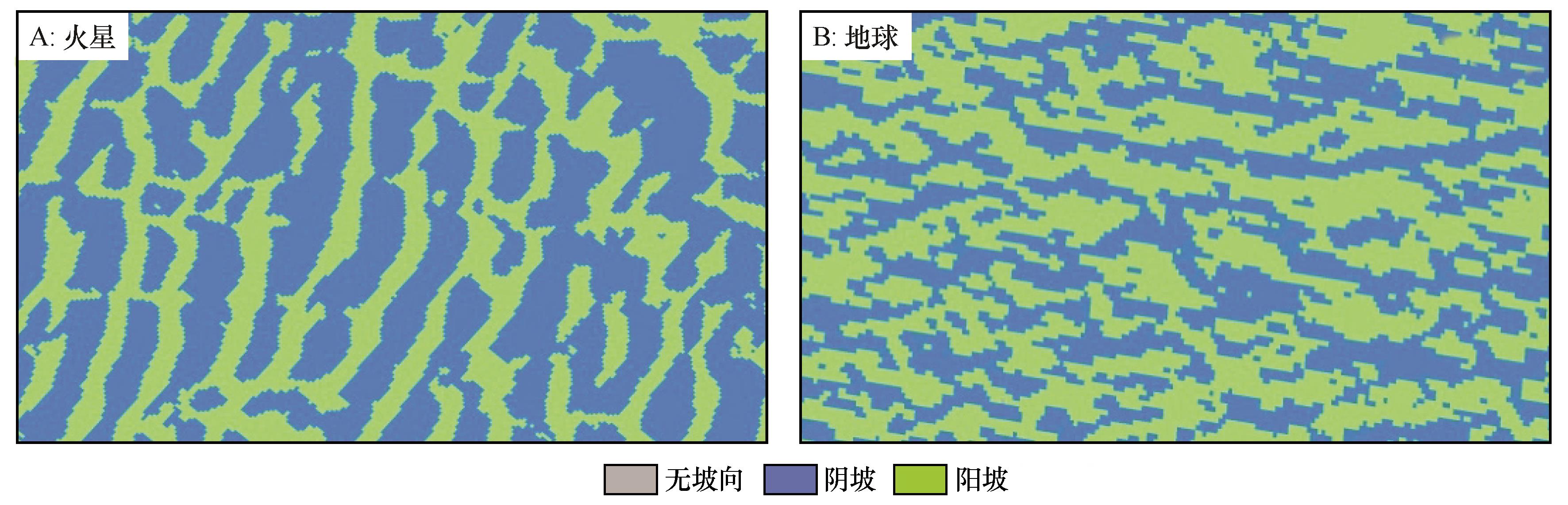
图9 研究区格状沙丘坡向图
Fig.9 Aaspect map of dune networks of studied sites on the Mars (A) and Earth (B)
| 研究区 | 特征值 | ||||||
|---|---|---|---|---|---|---|---|
| 最小值 | 最大值 | 均值 | 标准差 | 众数 | 中位数 | 变异系数 | |
| 火星 | 0.7 | 22 | 13.5 | 8.2 | 7.4 | 12.8 | 0.61 |
| 地球 | 0.6 | 30.7 | 22.9 | 12.9 | 5.9 | 23.1 | 0.56 |
表3 研究区坡度统计特征值 (°)
Table 3 Slope statistical characteristic values of studied sites
| 研究区 | 特征值 | ||||||
|---|---|---|---|---|---|---|---|
| 最小值 | 最大值 | 均值 | 标准差 | 众数 | 中位数 | 变异系数 | |
| 火星 | 0.7 | 22 | 13.5 | 8.2 | 7.4 | 12.8 | 0.61 |
| 地球 | 0.6 | 30.7 | 22.9 | 12.9 | 5.9 | 23.1 | 0.56 |
| 地形 因子 | 分级 | 比例/% | ||
|---|---|---|---|---|
| 火星 | 地球 | 差值 | ||
| 坡度 | 0°~3° | 8.2 | 8.4 | -0.2 |
| ≥3° | 91.8 | 91.6 | 0.2 | |
| 坡向 | 无坡向 | 1.0 | 0.5 | 0.5 |
| 阳坡 | 41.5 | 45.6 | -4.1 | |
| 阴坡 | 57.9 | 53.9 | 4.0 | |
表4 研究区坡度、坡向分级统计表
Table 4 Slope and aspect classification statistical of studied sites
| 地形 因子 | 分级 | 比例/% | ||
|---|---|---|---|---|
| 火星 | 地球 | 差值 | ||
| 坡度 | 0°~3° | 8.2 | 8.4 | -0.2 |
| ≥3° | 91.8 | 91.6 | 0.2 | |
| 坡向 | 无坡向 | 1.0 | 0.5 | 0.5 |
| 阳坡 | 41.5 | 45.6 | -4.1 | |
| 阴坡 | 57.9 | 53.9 | 4.0 | |
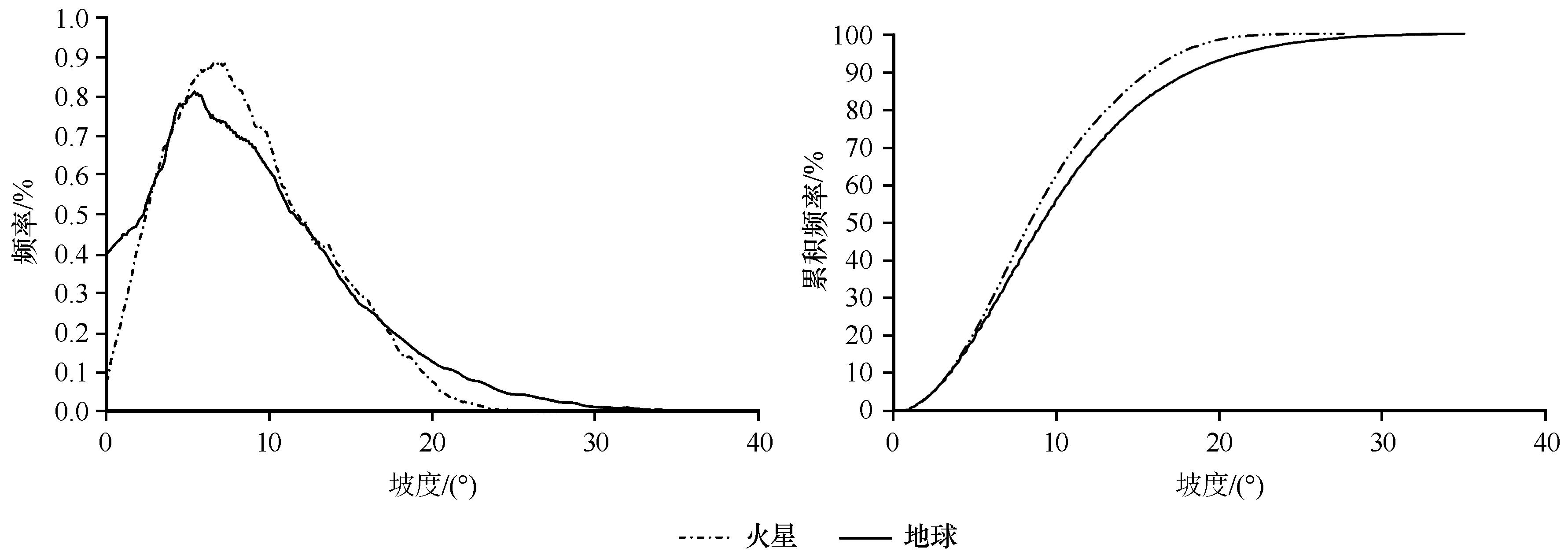
图10 研究区格状沙丘坡度频率
Fig.10 Slope histogram of the dune networks of studied sites
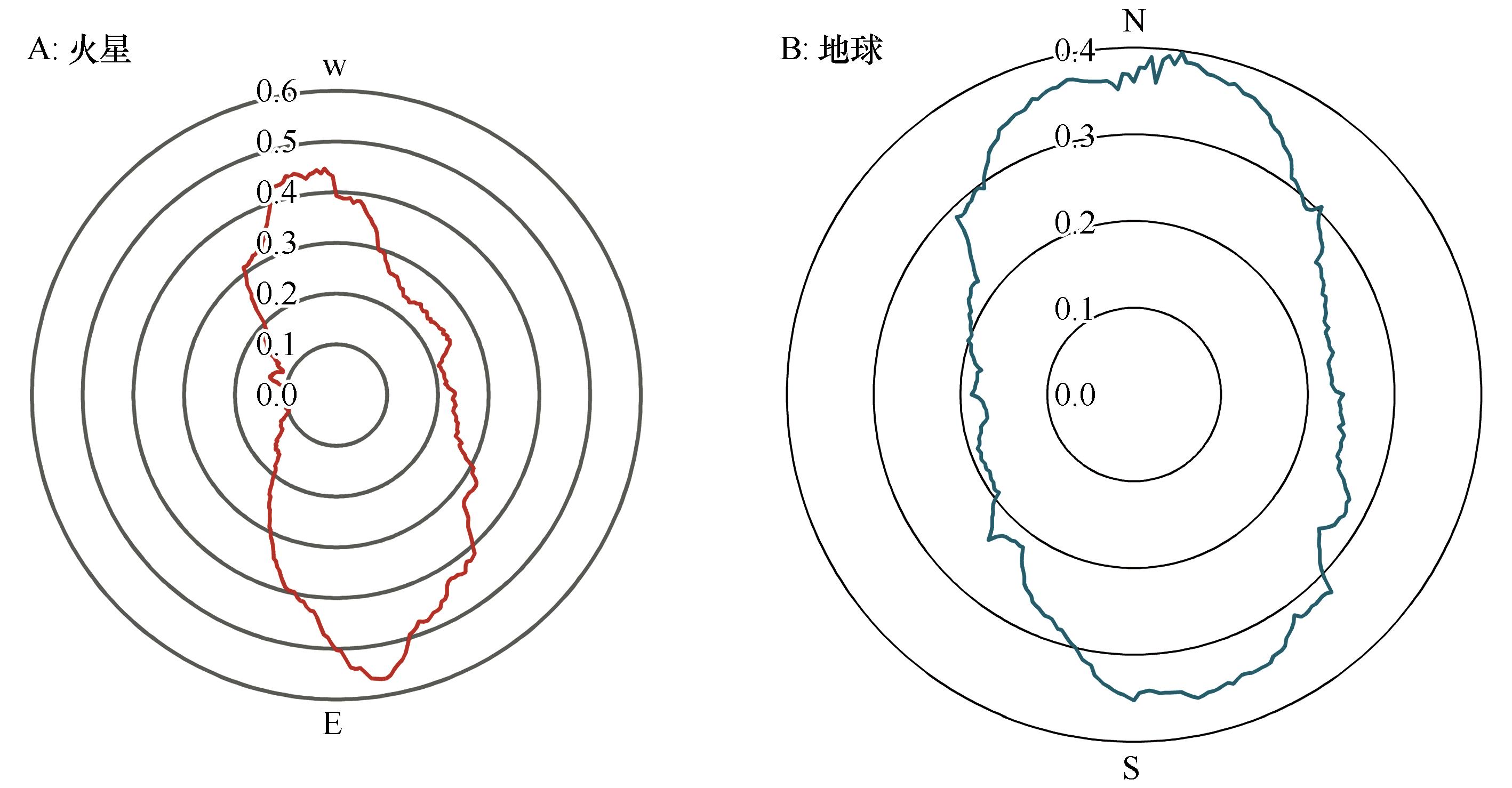
图11 研究区格状沙丘坡向雷达图
Fig.11 Aspect radar chart of the dune networks of studied sites on the Mars (A) and Earth (B)
| 尺度 /m | 分形维数(D) | ||
|---|---|---|---|
| 火星 | 地球 | 差值 | |
| 1 | 2.0002 | 2.0000 | 0.0002 |
| 10 | 2.0124 | 2.0083 | 0.0041 |
| 20 | 2.0568 | 2.0009 | 0.0559 |
| 30 | 2.0919 | 2.0486 | 0.0443 |
| 均值 | 2.0403 | 2.0144 | 0.0261 |
表5 研究区格状沙丘不同尺度的分形维数
Table 5 The fractal dimension of dune networks at different scales of studied sites
| 尺度 /m | 分形维数(D) | ||
|---|---|---|---|
| 火星 | 地球 | 差值 | |
| 1 | 2.0002 | 2.0000 | 0.0002 |
| 10 | 2.0124 | 2.0083 | 0.0041 |
| 20 | 2.0568 | 2.0009 | 0.0559 |
| 30 | 2.0919 | 2.0486 | 0.0443 |
| 均值 | 2.0403 | 2.0144 | 0.0261 |
| 1 | 周成虎.地貌学辞典[M].北京:中国水利水电出版社,2006. |
| 2 | 董治宝,吕萍.70年来中国风沙地貌学的发展[J].地理学报,2020,75(3):509-528. |
| 3 | 李振山,倪晋仁.国外沙丘研究综述[J].泥沙研究,2000,10(5):73-81. |
| 4 | Arens S M,Slings Q,Devries C N.Mobility of a remobilized parabolic dune in kennemer land,the-nether land[J].Geomorphology,2004,59:175-188. |
| 5 | 李恩菊.巴丹吉林沙漠与腾格里沙漠沉积物特征的对比研究[D].西安:陕西师范大学,2011. |
| 6 | Bridges N,Geissler P,Silvestro S,et al.Bedform migration on Mars:current results and future plans[J].Aeolian Research,2013,9:133-151. |
| 7 | Malin M C,Edgett K S.Mars global surveyor Mars orbiter camera:interplanetary cruise through primary mission[J].Journal of Geophysical Research-Planets,2001,106(E10):23429-23570. |
| 8 | Hayward R K,Fenton L K,Titus T N.Mars global digital dune database(MGD3):global dune distribution and wind pattern observations[J].Icarus,2014,230:38-46. |
| 9 | 李继彦,董治宝.火星风沙地貌研究进展[J].中国沙漠,2016,36(4):951-961. |
| 10 | 董治宝,吕萍,李超.火星风沙地貌研究方法[J].地球科学进展,2020,35(8):771-788. |
| 11 | Baldridge A M,Farmer J D,Moersch J E.Mars remote-sensing analog studies in the Badwater Basin,Death Valley,California[J].Journal of Geophysical Research-Planets,2004,109:E12006. |
| 12 | Cabrol N A,Wettergreen D,Warren-Rhodes K,et al.Life in the Atacama:searching for life with rovers (science overview)[J].Journal of Geophysical Research-Biogeosciences,2007,112:583-590. |
| 13 | Essefi E,Komatsu G,Fairen A G,et al.Groundwater influence on the aeolian sequence stratigraphy of the Mechertate-Chrita-Sidi EI Hani system,Tunisian Sahel:analogies to the wet-dry aeolian sequence stratigraphy at Meridiani Planum,Terby crater,and Gale crater,Mars[J].Planetary and Space Science,2014,95:56-78. |
| 14 | Angles A,Li Y L.The western Qaidam basin as a potential Martian environmental analogue:an overview[J].Journal of Geophysical Research-Planets,2017,122:856-888. |
| 15 | Wang A,Sobron P,Kong F,et al.Dalangtan saline playa in a hyperarid region on Tibet Plateau:II.preservation of salts with high hydration degrees in subsurface[J].Astrobiology,2018,18:1254-1276. |
| 16 | Xiao L,Wang J,Dang Y,et al.A new terrestrial analogue site for Mars research:the Qaidam Basin,Tibetan Platear(NW China)[J].Earth-Science Reviews,2017,164:84-101. |
| 17 | 包刚,曲帅屹,傅泽华,等.柴达木盆地红崖中国“火星村”选址区与火星的类比研究[J].矿物岩石地球化学通报,2020(39). |
| 18 | HengT,Reuter H.Geomorphmetry Concepts,Software,Application [M].Boston,USA:Elsevier,2009. |
| 19 | Wilson J P.Digital terrain modeling[J].Geomorphology,2012,137(1):107-121. |
| 20 | Lv G,Xiong L,Chen M,et al.Chinese progress in geomorphometry[J].Journal of Geographical Sciences,2017,27(11):1389-1412. |
| 21 | 曾永年,冯兆东,曹广超.末次冰期以来柴达木盆地沙漠形成与演化[J].地理学报,2003,58(3):452-457. |
| 22 | 何先虎.大柴旦盐湖柱硼镁石矿床的形成环境与气候特征[D].西宁:中国科学院青海盐湖研究所,2014. |
| 23 | 董治宝.青藏高原风沙地貌图集[M].西安:西安地图出版社,2017:14-15. |
| 24 | 刘英姿.腾格里沙漠中格状沙丘形态及成因研究[D].西安:陕西师范大学,2013. |
| 25 | 哈斯,董光荣,王贵勇.腾格里沙漠东南缘格状沙丘的形态-动力学研究[J].中国科学D辑:地球科学,1999(5):466-471. |
| 26 | Cook R,Warren A,Goudie A.Desert Geomorphology[M].London,UK:UCL Press,1994:368-396. |
| 27 | Glasby G P.Mars,our neighbor[J].Geology Today,2012,28(6):214-246. |
| 28 | 欧阳自远,肖福根.火星探测的主要科学问题[J].航天器环境工程,2011,28(3):205-217. |
| 29 | Yu L,Lai Z.OSL chronology and palaeoclimatic implications of aeolian sediments in the eastern Qaidam Basin of the northeastern Qinghai-Tibetan Plateau[J].Palaeogeography,Palaeoclimatology,Palaeoecology,2012,337-338:120-129. |
| 30 | Chojnacki M,Burr D M,Moersch J E.Valles Marineris dune fields as compared with other martian populations:diversity of dune compositions,morphologies,and thermophysical properties[J].Icarus,2014,230:96-142. |
| 31 | Hayward R K,Mullins K F,Fenton L K,et al.Mars global digital dune database and initial science results[J].Journal of Geophysical Research,2007,112(E11007):1-17. |
| 32 | https://planetarynames.wr.usgs.gov/Feature/14281[Z]. |
| 33 | Massé M,Bourgeois O,Le Mouélic S,et al.Martian polar and circum-polar sulfate-bearing deposits:sublimation tills derived from the North Polar Cap[J].Icarus,2010,209(8):434-451. |
| 34 | Kenneth L,Tanaka J,Alexis P,et al.North polar region of Mars:advances in stratigraphy,structure,and erosional modification[J].Icarus,2008,196(2):318-358. |
| 35 | 董治宝,李超,吕萍.火星风沙地貌图[M].西安:西安地图出版社,2020. |
| 36 | 张正偲,董治宝.风沙地貌形态动力学研究进展[J].地球科学进展,2014,29(6):734-747. |
| 37 | Olaya V.Basic land-surface parameters[J].Developments in Soil Science,2009,8(33):141-169. |
| 38 | Gonzalez R C,Woods R E.Digital Image Processing[M] Beijing,China:Publishing House of Electroics Industry,2010. |
| 39 | Shary P A,Sharaya L S,Mitusov A V.Fundamental quantitative methods of land surface analysis[J].Geoderma,2002,107(1):1-32. |
| 40 | Swain M J,Ballard D H.Color indexing[J].International Journal of Computer Vision,1991,7(1):11-32. |
| 41 | Stricker M,Orengo M.Similarity of color images[J].Proceedings of SPIE-the International Society for Optical Engineering,1995,2420:381-392. |
| 42 | 汤国安,刘学军,闾国年.数字高程模型及地学分析的原理与方法[M].北京:科学出版社,2005. |
| 43 | 丛殿阁,庞红丽,方苗,等.基于DEM和ETM的腾格里沙漠北缘沙丘形态特征提取[J].中国矿业,2014,23():153-159. |
| 44 | Mandelbort B B.The Fractal Geometry of Nature[M].New York,USA:Freeman,1982. |
| 45 | 徐建华,艾南山.沙漠化的分形特征研究[J].中国沙漠,2002,22(1):6-10. |
| 46 | Clarke K C.Computation of the fractal dimension of topographic surfaces using the triangular prism surface area method[J].Computers & Geosciences,1989,12(5):713-722. |
| 47 | 李超,董治宝,吕萍,等.火星沙丘地貌的形态学窥究[J].科学通报,2020,65(1):80-90. |
| 48 | 龙毅,周侗,汤国安,等.典型黄土地貌类型区的地形复杂度分形研究[J].山地学报,2007,25(4):385-392. |
| 49 | Ewing R C,Kocurek G,Lake L W.Pattern analysis of dune-field parameters[J].Earth Surface Processes and Landforms,2006(31):1176-1191. |
| 50 | 汪克奇,赵晖,Sheng Yongwei,等.基于DEM数据的巴丹吉林沙漠沙丘分布规律及其形态参数[J].中国沙漠,2020,40(4):81-94. |
| 51 | 赵孜博,杨勤科,王春梅.坡度统计分析的最小面积阈值研究[J].测绘科学,2020,45(2):172-177. |
| 52 | 董治宝,吕萍.深空探测时代的风沙地貌学[J].地球科学进展,2019,34(10):1001-1014. |
| 53 | Kong F,Kong W,Hu B,et al.Sedimentary salts at Dalangtan Playa and its implication for the formation and preservation of martian salts[C]//Lunar and Planetary Science Conference,2013:1336. |
| 54 | Mayer D,Arvidson R,Wang A,et al.Mapping minerals at a potential Mars analog site on the Tibetan Plateau[C]//Lunar and Planetary Science Conference,2009:1877. |
| 55 | Wang A,Zheng M.Evaporative salts from saline lakes on Tibetan Plateau:an analog for salts on Mars[C]//Lunar and Planetary Science Conference,2009:1858. |
| 56 | Zheng M,Kong W,Zhang X,et al.A comparative analysis of evaporate sediments on Earth and Mars:implications for the climate change on Mars[J].Acta Geologica Sinica,2013,87 (3):885-897. |
| 57 | Dong Z,Hu G,Qian G,et al.High-altitude aeolian research on the Tibetan Plateau[J].Reviews of Geophysics,2017,55(4):864-901. |
| [1] | 郜学敏, 屈欣, 王萌, 张思悦, 张姚姚, 李继彦. 柴达木盆地西北部长垄状雅丹沉积物地球化学元素组成及指示意义[J]. 中国沙漠, 2021, 41(3): 127-136. |
| [2] | 王文帆, 刘任涛, 郭志霞, 冯永宏, 蒋嘉瑜. 腾格里沙漠东南缘固沙灌丛林土壤理化性质及分形维数[J]. 中国沙漠, 2021, 41(1): 209-218. |
| [3] | 曾方明, 薛红盼. 青藏高原东北部晚第四纪黄土-古土壤的元素组成及其物源指示[J]. 中国沙漠, 2020, 40(6): 105-117. |
| [4] | 杜慧荣, 谢远云, 康春国, 迟云平, 王嘉新, 孙磊. 哈尔滨黄土的粒度与地球化学特征及其对粉尘物源的指示[J]. 中国沙漠, 2020, 40(1): 64-76. |
| [5] | 李继彦, 周玲, 刘益, 张倩, 蔡莹莹, 张宝贵. 晋西北地区表层土壤粒度与地球化学元素组成[J]. 中国沙漠, 2019, 39(5): 155-162. |
| [6] | 王国玲, 苏志珠, 毛丽, 张秋华, 马义娟. 中国北方农牧交错带鄂尔多斯高原段土壤表层粒度特征[J]. 中国沙漠, 2019, 39(3): 183-190. |
| [7] | 凌智永, 王建萍, 陈亮, 芦宝良. 柴达木盆地灌丛沙丘稀土元素地球化学特征与物源[J]. 中国沙漠, 2018, 38(5): 963-971. |
| [8] | 李露露, 董治宝, 李超, 崔徐甲, 肖巍强, 肖南. 火星和地球雅丹形态学类比分析——以埃律西昂平原和柴达木盆地为例[J]. 中国沙漠, 2018, 38(4): 716-723. |
| [9] | 陈国祥, 董治宝, 崔徐甲, 肖巍强, 李露露, 杨军怀, 石唯康. 毛乌素沙地中部风成沙的组成与微形态特征[J]. 中国沙漠, 2018, 38(3): 473-483. |
| [10] | 丁之勇, 马龙, 吉力力·阿不都外力, 刘文, 葛拥晓. 新疆艾比湖湖泊沉积物元素地球化学记录及其生态环境意义[J]. 中国沙漠, 2018, 38(1): 101-110. |
| [11] | 孙传龙, 张卓栋, 邱倩倩, 刘亮. 锡林郭勒草地表层土壤粒度分形特征及其与风蚀的关系[J]. 中国沙漠, 2017, 37(5): 978-985. |
| [12] | 曹乐, 聂振龙, 刘学全, 王哲, 孟令群, 姜高磊. 巴丹吉林沙漠湖泊钙华的水化学成因[J]. 中国沙漠, 2017, 37(5): 1026-1034. |
| [13] | 崔徐甲, 孙虎, 董治宝, 李继彦, 郜学敏, 李超. 巴丹吉林沙漠高大沙山沉积物地球化学元素组成及其环境意义[J]. 中国沙漠, 2017, 37(1): 17-25. |
| [14] | 赵光辉, 苏芳莉, 李海福, 李一鸣. 辽河干流上游流域土地利用对土壤颗粒分形维数影响[J]. 中国沙漠, 2016, 36(6): 1622-1627. |
| [15] | 李继彦, 董治宝. 火星风沙地貌研究进展[J]. 中国沙漠, 2016, 36(4): 951-961. |
| 阅读次数 | ||||||
|
全文 |
|
|||||
|
摘要 |
|
|||||
©2018中国沙漠 编辑部
地址: 兰州市天水中路8号 (730000)
电话:0931-8267545
Email:caiedit@lzb.ac.cn;desert@lzb.ac.cn

 甘公网安备 62010202000688号