img

官方微信

高级检索

中国沙漠 ›› 2022, Vol. 42 ›› Issue (2): 44-53.DOI: 10.7522/j.issn.1000-694X.2021.00108

• • 上一篇    下一篇

甘肃河西地区20002019年水土资源耦合协调特征

王凌阁1(), 朱睿1(), 陈泽霞1, 尹振良2, 卢睿1, 方春爽1   

  1. 1.兰州交通大学 测绘与地理信息学院/地理国情监测技术应用国家地方联合工程研究中心/甘肃省地理国情监测工程实验室,甘肃 兰州 730000
    2.中国科学院西北生态环境资源研究院 内陆河流域生态水文重点实验室,甘肃 兰州 730000
  • 收稿日期:2021-07-13 修回日期:2021-08-19 出版日期:2022-03-20 发布日期:2022-03-30
  • 通讯作者: 朱睿
  • 作者简介:朱睿(E-mail: zhur@mail.lzjtu.cn
    王凌阁(1999—),女,河南南阳人,硕士研究生,主要从事干旱区水土资源耦合研究。E-mail: 11200865@stu.lzjtu.edu.cn
  • 基金资助:
    国家自然科学基金项目(42161018);中国科学院青年创新促进会项目;甘肃省重点研发计划项目(20YF8FA002);兰州交通大学优秀平台(201806)

Coupling effect of water-soil resources in Hexi Area of GansuChina in 2000-2019

Lingge Wang1(), Rui Zhu1(), Zexia Chen1, Zhenliang Yin2, Rui Lu1, Chunshuang Fang1   

  1. 1.Faculty of Geomatics / National-Local Joint Engineering Research Center of Technologies and Applications for National Geographic State Monitoring / Gansu Provincial Engineering Laboratory for National Geographic State Monitoring,Lanzhou Jiaotong University,Lanzhou 730000,China
    2.Key Laboratory of Ecohydrology of Inland River Basin,Northwest Institute of Eco-Environment and Resources,Chinese Academy of Sciences,Lanzhou 730000,China
  • Received:2021-07-13 Revised:2021-08-19 Online:2022-03-20 Published:2022-03-30
  • Contact: Rui Zhu

摘要:

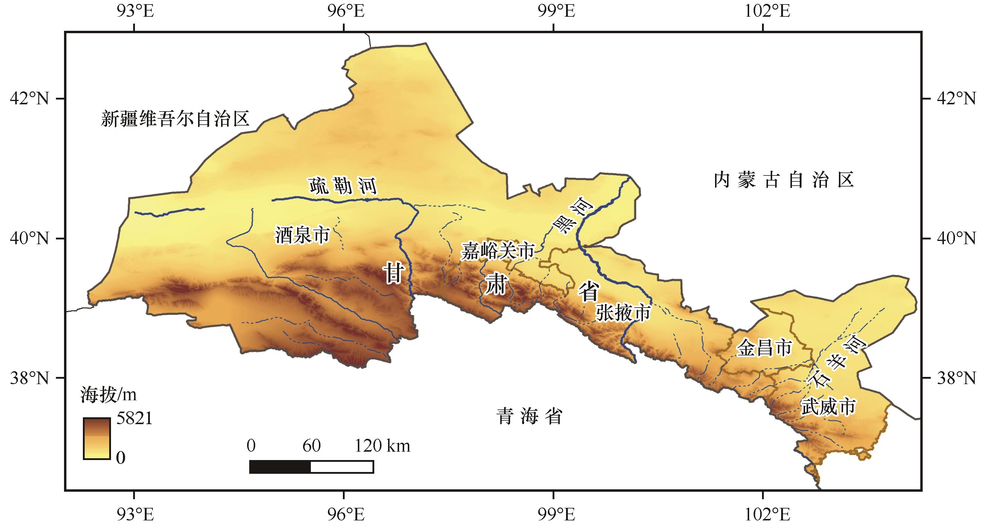
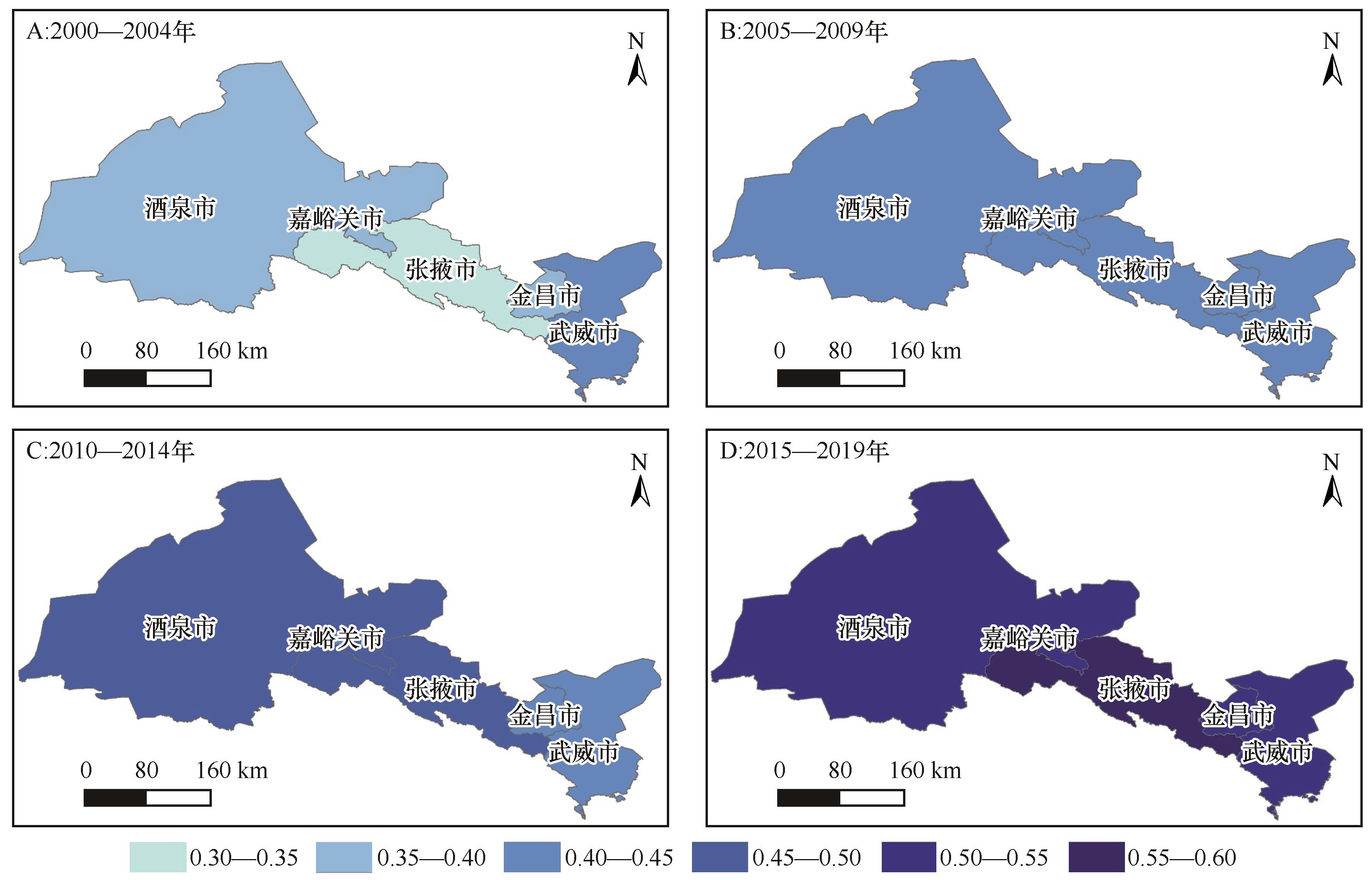
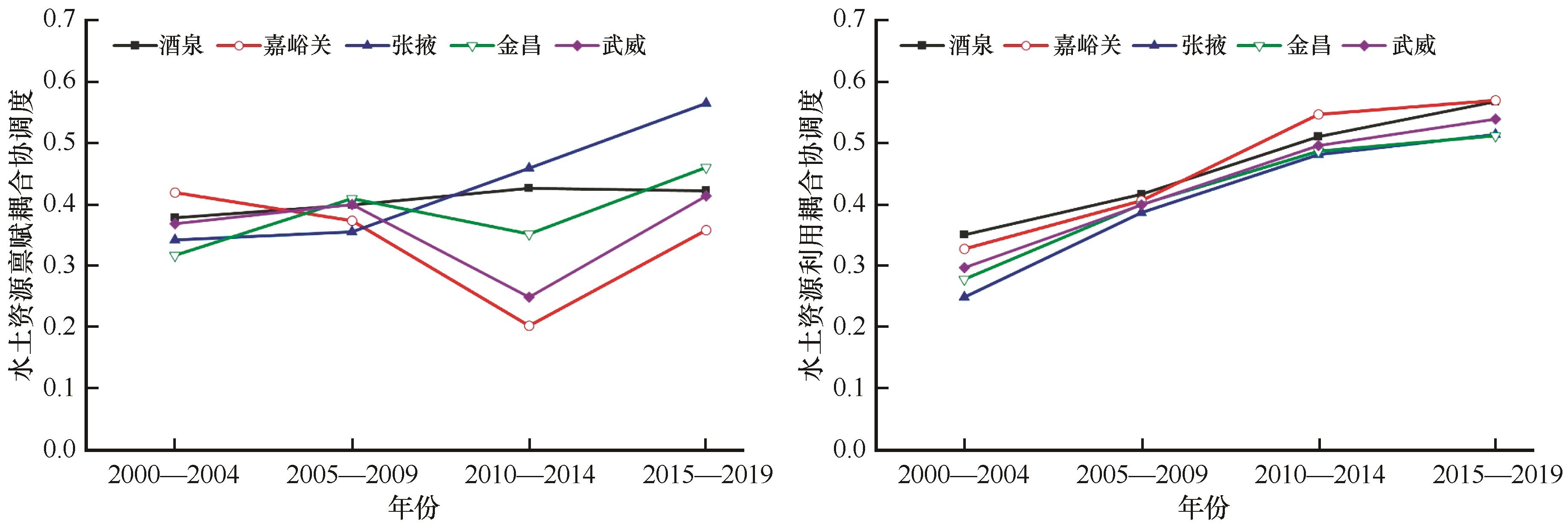
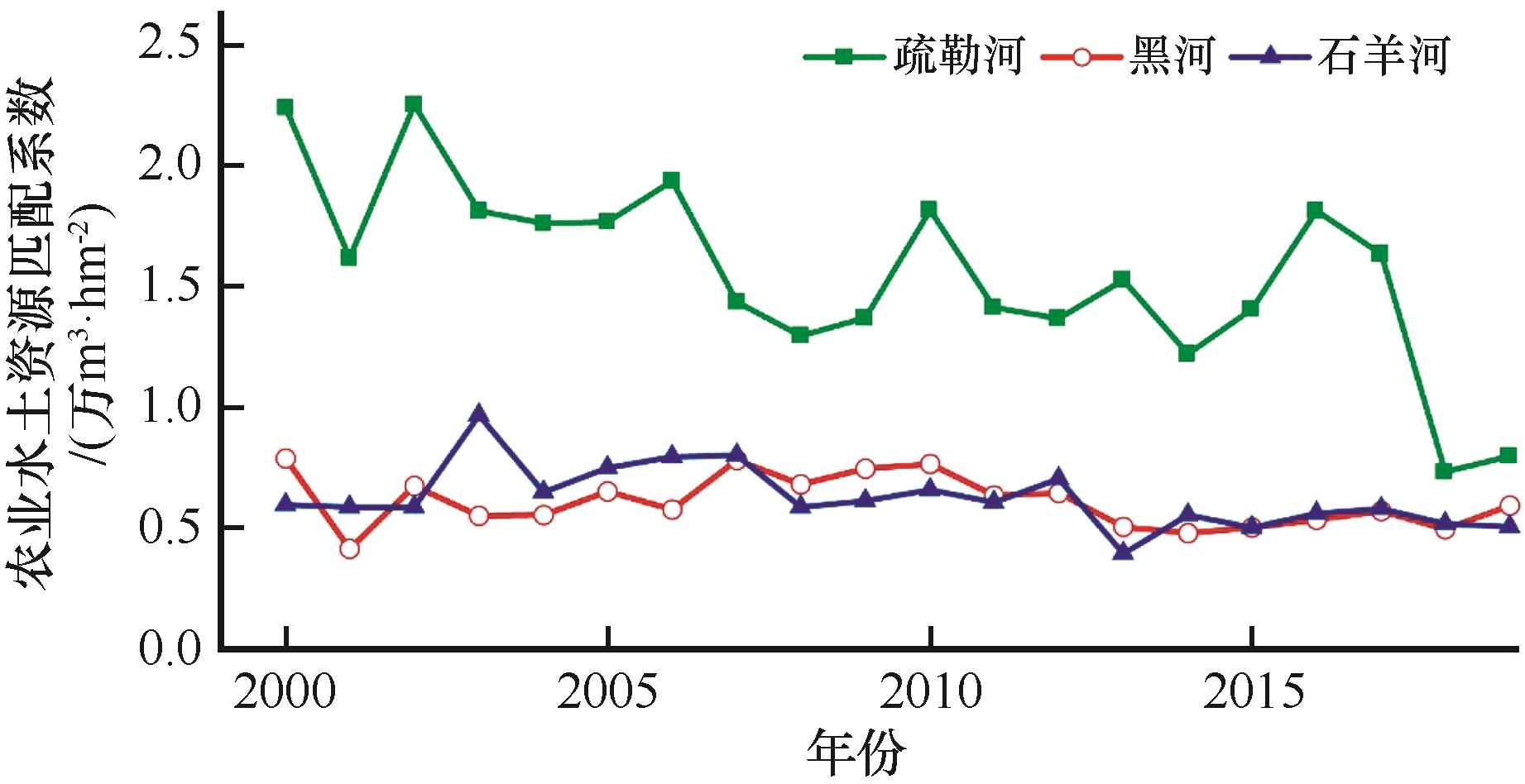
以甘肃河西地区为研究区,采用耦合协调度模型和农业水土资源匹配系数法分别对河西五市和河西走廊三大内陆河中游地区水土耦合协调情况进行量化研究,并以此为基础通过灰色关联度法分析水土资源耦合协调度影响因素。结果表明:(1)2000—2019年,河西五市水土资源耦合协调度整体提升了64.65%,由濒临失调转换为初级协调,呈现不断改善的趋势。其中,张掖市、酒泉市水土资源耦合程度增长较高;(2)影响河西五市水土资源耦合协调的主要因素分别为水资源系统的人均水资源量、降水资源总量和水资源总量以及土地资源系统的地均粮食产量、耕地比例和地均农业总产值;(3)河西走廊三大内陆河中游地区水土匹配情况存在较大差异,疏勒河流域耦合度最高,但是却呈波动下降趋势,黑河流域和石羊河流域水土耦合程度变化小。应继续坚持节水技术推广,促进农业向高效益、低耗水方向发展,同时注重水土资源的合理开发和保护,因地制宜,逐步实现水土资源的高效配置。

关键词: 水土资源耦合, 河西, 内陆河流域, 匹配系数

Abstract:

In this paper, we take the Hexi Corridor of Gansu as the research area, use the coupling coordination model and the agricultural water-soil resource matching coefficient method to quantify the water-soil coupling coordination in the five cities of Hexi Corridor and the middle reaches of the three inland river basins in Hexi Corridor, and on this basis, the influencing factors of soil resources and water resources are analyzed by grey correlation analysis. The main research results are as follows: (1)From 2000 to 2019, the overall coupling coordination degree of water-soil resources in five cities of Hexi has increased by 64.65%, and it is on the verge of imbalance to primary coordination, showing a trend of continuous improvement. Among them, the coupling degree of water-soil resources in Zhangye City and Jiuquan city increased higher. (2)The main factors affecting the coupling coordination of water-soil resources in the five cities of Hexi are the per capita water resources, the total precipitation resources and the total water resources of the water resources system, and the average grain yield, the proportion of cultivated land and the average agricultural output value of the land resources system. (3)In the middle reaches of the three inland rivers in Hexi Corridor, the coupling degree of Shule River Basin is the highest, but it shows a fluctuating downward trend, while the coupling degree of Heihe River Basin and Shiyang River Basin changes little. Therefore, we should continue to adhere to the promotion of water-saving technology, promote the development of agriculture to the direction of high efficiency and low water consumption, pay attention to the rational development and protection of water-soil resources, and gradually realize the efficient allocation of water-soil resources according to local conditions.

Key words: coupling effect of water-soil resources, Hexi Corridor, inland river basins, matching coefficient

中图分类号: