| 1 |
Sun W Y, Song X Y, Mu X M,et al.Spatiotemporal vegetation cover variations associated with climate change and ecological restoration in the Loess Plateau[J].Agricultural and Forest Meteorology,2015,209/210:87-99.
|
| 2 |
杨舒畅,杨恒山.1982-2013年内蒙古地区干旱变化及植被响应[J].自然灾害学报,2019,28(1):175-183.
|
| 3 |
崔林丽,史军,杨引明,等.中国东部植被NDVI对气温和降水的旬响应特征[J].地理学报,2009,64(7):850-860.
|
| 4 |
Faour G, Mhawej M, Nasrallah A.Global trends analysis of the main vegetation types throughout the past four decades[J].Applied Geography,2018,97:184-195.
|
| 5 |
徐浩杰,杨太保.柴达木盆地植被生长时空变化特征及其对气候要素的响应[J].自然资源学报,2014,29(3):398-409.
|
| 6 |
刘斌,孙艳玲,王中良,等.华北地区植被覆盖变化及其影响因子的相对作用分析[J].自然资源报,2015,30(1):12-23.
|
| 7 |
邹明亮,韩雅敏,曾建军,等.基于Albedo-NDVI特征空间的玛曲县荒漠化时空动态监测[J].冰川冻土,2019,41(1):45-53.
|
| 8 |
Magney T S, Eitel J U H, Huggins D R,et al.Proximal NDVI derived phenology improves in-season predictions of wheat quantity and quality[J].Agricultural and Forest Meteorology,2016,217:46-60.
|
| 9 |
韩子言,蒙吉军,邹易,等.1982-2017年黑河流域植被指数动态及其对气候变化与生态建设工程的响应[J].中国沙漠,2023,43(3):96-106.
|
| 10 |
谢绮丽,杨鑫,郝丽娜.2001-2020年三江源区植被覆盖时空变化特征及其影响因素[J].水土保持通报,2022,42(5):202-212.
|
| 11 |
Eckert S, Hüsler F, Liniger H,et al.Trend analysis of MODIS NDVI time series for detecting land degradation and regeneration in Mongolia[J].Journal of Arid Environments,2015,113:16-28.
|
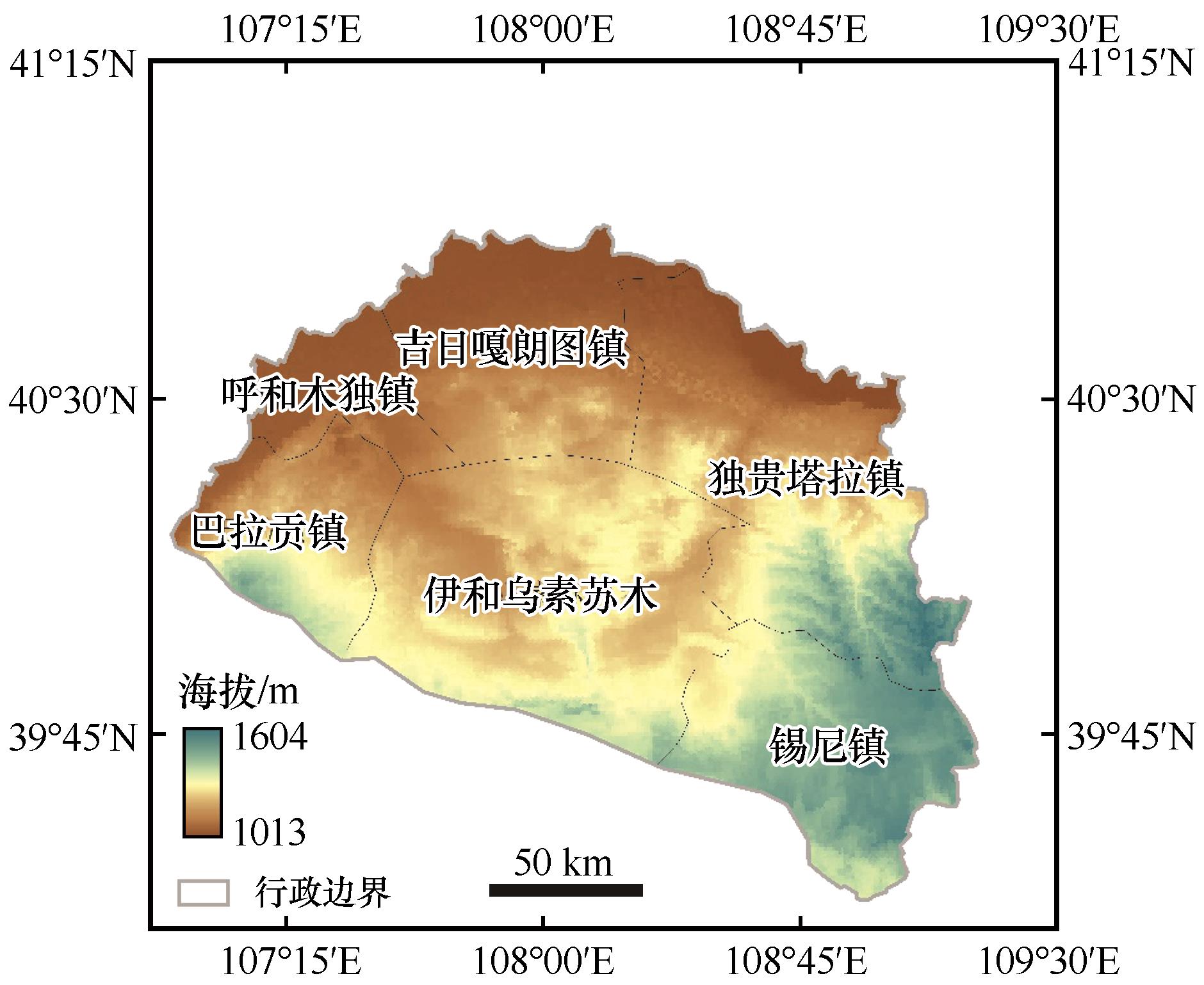
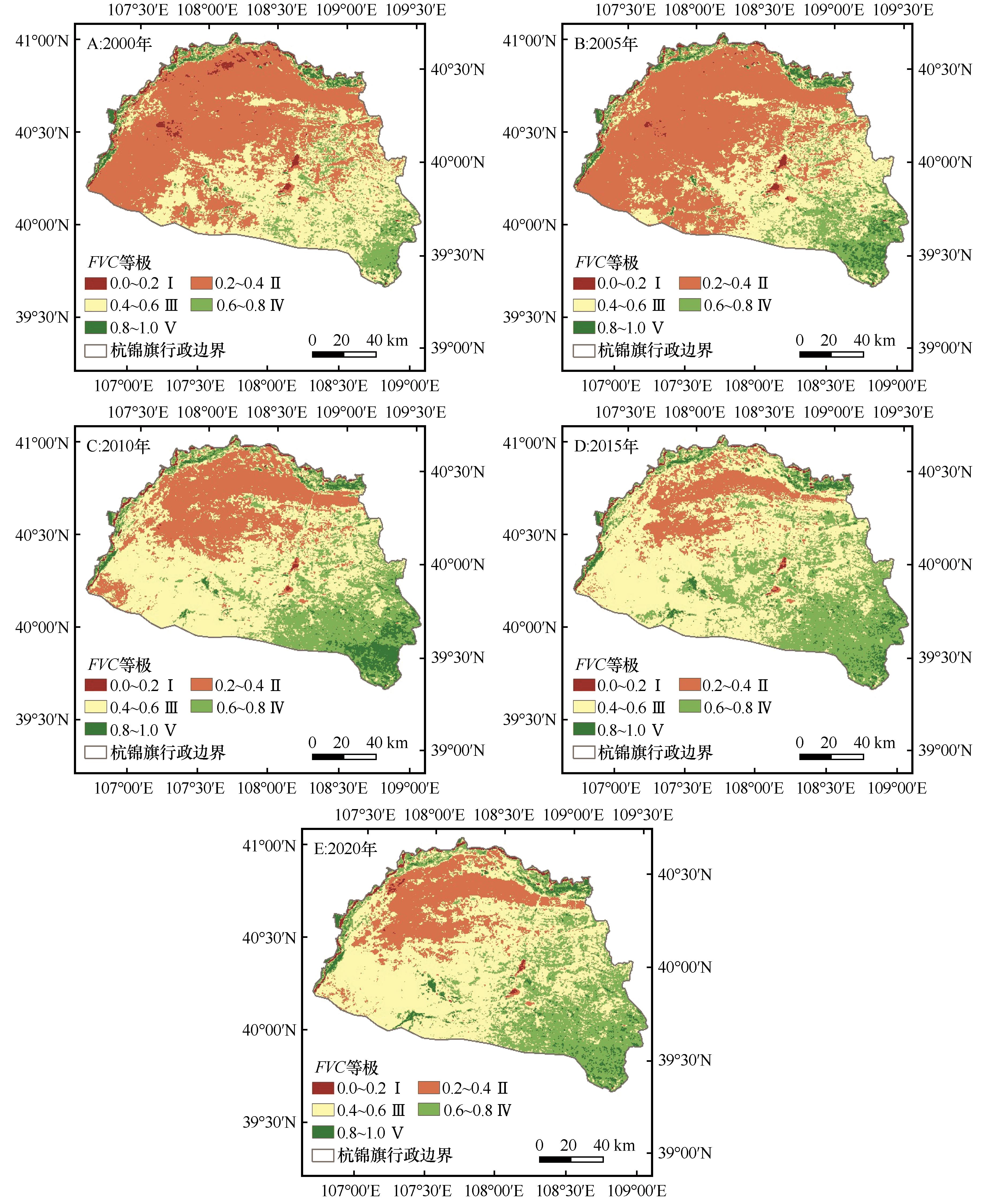
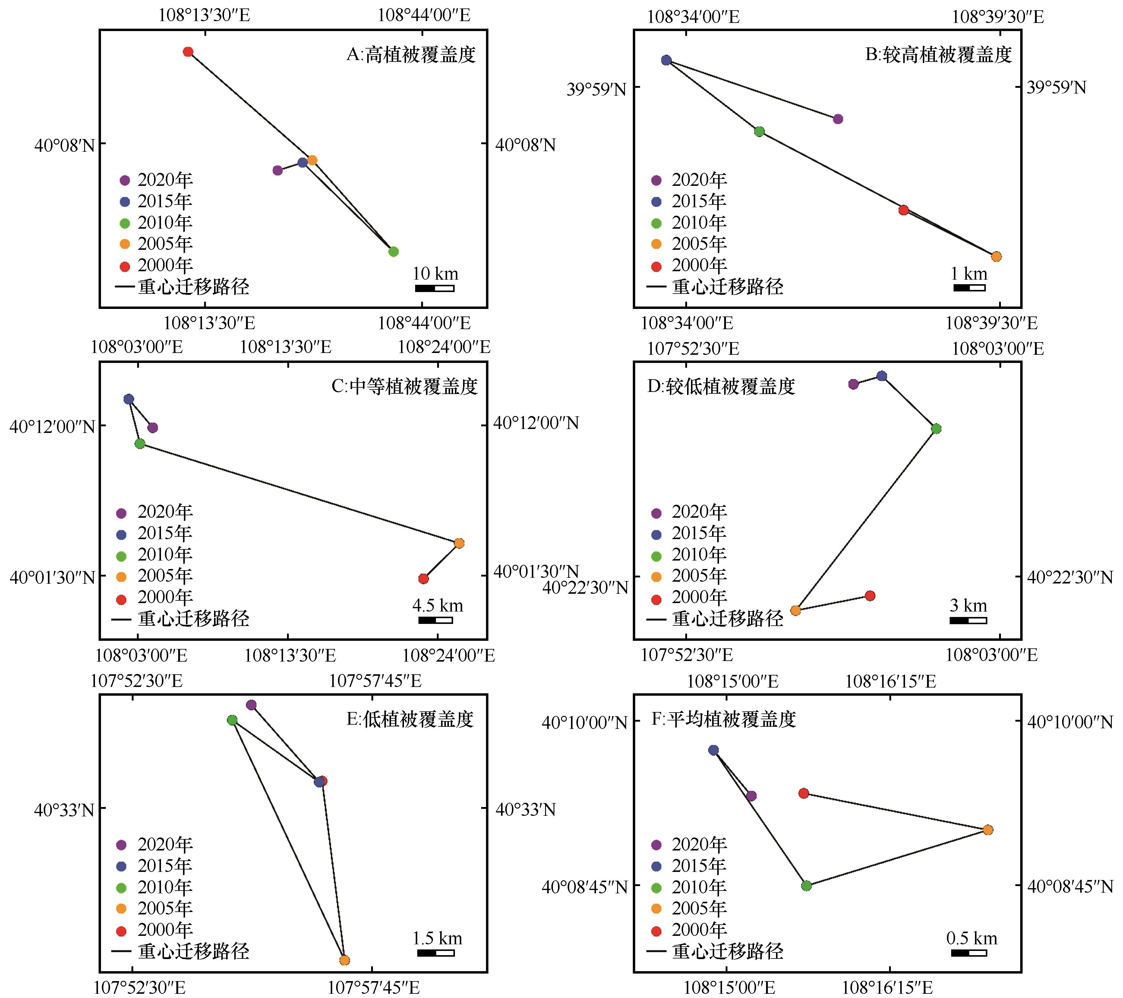
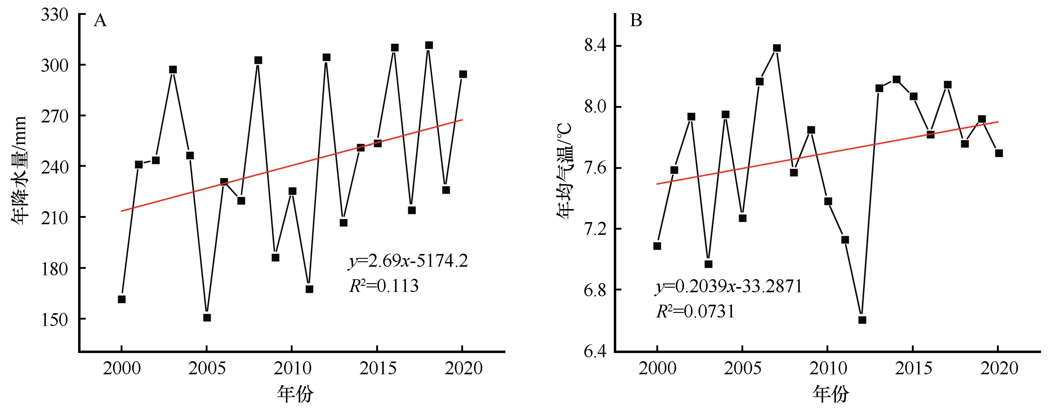
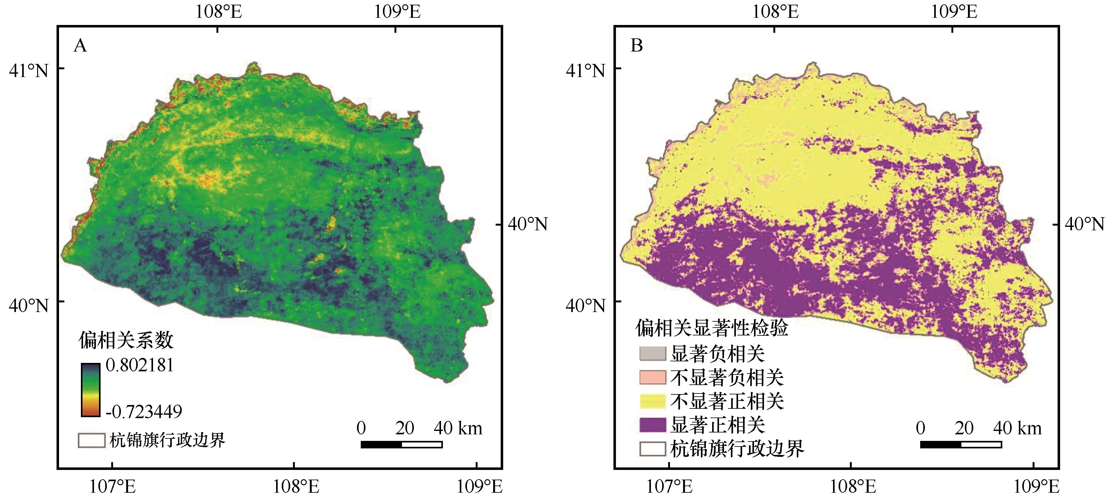
| 12 |
高翔,黄星星,刘宽梅,等.祁连山自然保护区植被对气候变化的响应[J].兰州大学学报(自然科学版),2022,58(1):79-88.
|
| 13 |
Wang Y, Peng D L, Shen M G,et al.Contrasting effects of temperature and precipitation on vegetation greenness along elevation gradients of the Tibetan Plateau[J].Remote Sensing,2020,12(17):2751.
|
| 14 |
Tian H W, Ji X J, Zhang F M.Spatiotemporal variations of vegetation net primary productivity and its response to meteorological factors across the Yellow River Basin during the period 1981-2020[J].Frontiers in Environmental Science,2022,10:949564.
|
| 15 |
刘钦普,林振山.气候变暖与荒漠-草原过渡带植物动态响应灰色分析:以美国新墨西哥州Sevilleta生态过渡带为例[J].生态学杂志,2005,24(7):756-762.
|
| 16 |
滑永春,马秀枝,斯琴毕力格.内蒙古荒漠草原植被降水利用效率的时空特征[J].中国沙漠,2021,41(4):51-58.
|
| 17 |
Tang Z, An H, Deng L,et al.Effect of desertification on productivity in a desert steppe[J].Scientific Reports,2016,6:27839.
|
| 18 |
甄慧,汪洋,夏婷婷,等.基于地理探测器的开都-孔雀河流域植被覆盖度时空变化及驱动力分析[J].草业科学,2023,40(5):1140-1153.
|
| 19 |
庞鑫,刘珺.气候变化对亚洲地区植被NDVI变化的影响[J].自然资源遥感,2023,35(2):295-305.
|
| 20 |
郭磊,王世东.河南省近30年植被指数与气象因子的相关性分析[J].生态科学,2018,37(5):102-112.
|
| 21 |
赵传武,郭伟,阎跃观,等.典型资源型城市的植被覆盖变化及驱动力分析:以鄂尔多斯市为例[J].遥感技术与应用,2022,37(2):389-398.
|
| 22 |
苗旭,李九一,宋小燕,等.2000-2020年鄂尔多斯市植被NDVI变化格局及归因分析[J].水土保持研究,2022,29(3):300-307.
|
| 23 |
杨泽康,田佳,李万源,等.黄河流域生态环境质量时空格局与演变趋势[J].生态学报,2021,41(19):7627-7636.
|
| 24 |
王旭洋,李玉霖,连杰,等.半干旱典型风沙区植被覆盖度演变与气候变化的关系及其对生态建设的意义[J].中国沙漠,2021,41(1):183-194.
|
| 25 |
祝聪,彭文浦,张瑞丽,等.2006-2016年岷江上游植被覆盖度时空变化及驱动力[J].生态学报,2019,39(5):1583-1594.
|
| 26 |
陈效逑,王恒.1982-2003年内蒙古植被带和植被覆盖度的时空变化[J].地理学报,2009,64(1):84-94.
|
| 27 |
李雪银,张志强,孙爱芝.1982-2021年黄河流域植被覆盖时空演变及影响因素研究[J].地理环境学报,2022,13(4):428-436.
|
| 28 |
陶帅,邝婷婷,彭文甫,等.2000-2015年长江上游NDVI时空变化及驱动力:以宜宾市为例[J].生态学报,2020,40(14):5029-5043.
|
| 29 |
董弟文,阿布都热合曼·哈力克,王大伟,等.1994-2016年和田绿洲植被覆盖时空变化分析[J].生态学报,2019,39(10):3710-3719.
|
| 30 |
钟鼎杰,杨存建.2001-2020年川西高原植被EVI时空变化特征及气候因子驱动力分析[J].水土保持研究,2022,29(4):223-230.
|
| 31 |
孙高鹏,刘宪锋,王小红,等.2001-2020年黄河流域植被覆盖变化及其影响因素[J].中国沙漠,2021,41(4):205-212.
|
| 32 |
段翰晨,王涛,薛娴,等.基于RS与GIS的科尔沁沙地沙漠化时空演变[J].中国沙漠,2013,33(2):470-477.
|
| 33 |
郭秀丽,李旺平,周立华.生态政策驱动下的内蒙古自治区杭锦旗植被覆盖变化[J].草业科学,2018,35(8):1843-1851.
|
| 34 |
张皓月,占车生,夏军,等.黄河流域内蒙古段植被时空变化特征及条带状分布成因研究[J].生态学报,2022,42(21):1-12.
|
| 35 |
缑倩倩,刘婧,王国华,等.晋西北丘陵风沙区柠条林下草本植物群落组成和种群生态位变化特征[J].生态学报,2022,42(22):9069-9090.
|
| 36 |
缑倩倩.晋西北丘陵风沙区人工柠条林建设与营造[M].北京:气象出版社,2022.
|
| 37 |
李重阳,樊文涛,李国梅,等.基于NDVI的2000-2016年青藏高原牧户+草场覆盖度变化驱动力分析[J].草业学报,2019,28(10):25-32.
|
| 38 |
赵明伟,王妮,施慧慧,等.2001-2015年间我国.陆地植被覆盖度时空变化及驱动力分析[J].干旱区地理,2019,42(3):324-331.
|
| 39 |
焦越佳,张佳雨,黄馨慧,等.内蒙古荒漠草原东部植被指标动态变化及其与气候变化的关系[J].草地学报,2022,30(1):153-160.
|
| 40 |
张清雨,吴绍洪,赵东升,等.内蒙古草地生长季植被变化对气候因子的响应[J].自然资源学报,2013,28(5):754-764.
|
 ), 张德全3, 刘勇3, 旭日干3, 谢胜波1(

 甘公网安备 62010202000688号