img

官方微信

高级检索

中国沙漠 ›› 2024, Vol. 44 ›› Issue (5): 133-142.DOI: 10.7522/j.issn.1000-694X.2024.00047

• • 上一篇    下一篇

腾格里沙漠土壤水分含量与地形、植被的关系

宁婷1(), 张定海1(), 赵有益1, 江晶2   

  1. 1.甘肃农业大学,理学院 数量生物研究所,甘肃 兰州 730070
    2.甘肃农业大学,管理学院,甘肃 兰州 730070
  • 收稿日期:2024-01-31 修回日期:2024-04-25 出版日期:2024-09-20 发布日期:2024-10-15
  • 通讯作者: 张定海
  • 作者简介:张定海(E-mail: zhangdh@gsau.edu.cn
    宁婷(2001—),女,甘肃张掖人,硕士研究生,主要从事生态水文模型研究。E-mail: 18089489751@163.com
  • 基金资助:
    国家自然科学基金项目(42361016);甘肃省科技创新计划-“西部之光”人才计划项目(22JR9KA032);甘肃省科技计划项目(21JR7RA831);甘肃农业大学青年导师扶持基金项目(GAU-QDFC-2023-07);甘肃省重点研发计划-农业领域项目(23YFNA0036)

Relationship between soil moisture and topography and vegetation in the Tengger Desert

Ting Ning1(), Dinghai Zhang1(), Youyi Zhao1, Jing Jiang2   

  1. 1.Center for Quantitative Biology,College of Science /, Gansu Agricultural University,Lanzhou 730070,China
    2.College of Management, Gansu Agricultural University,Lanzhou 730070,China
  • Received:2024-01-31 Revised:2024-04-25 Online:2024-09-20 Published:2024-10-15
  • Contact: Dinghai Zhang

摘要:

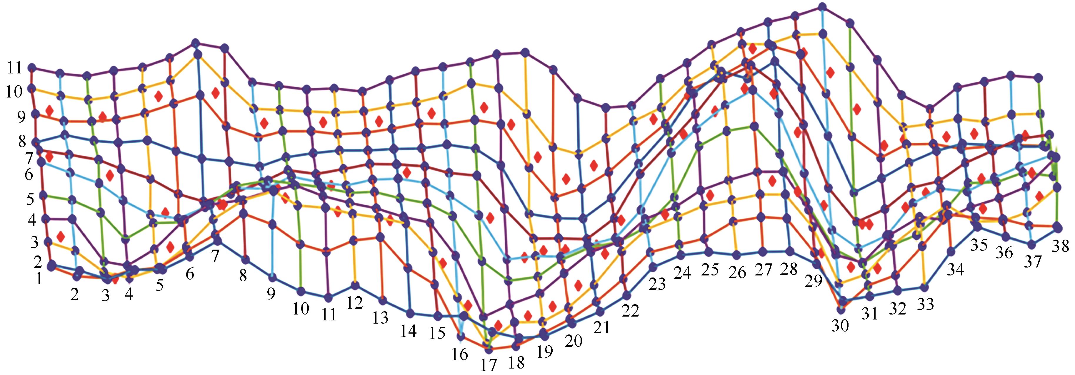
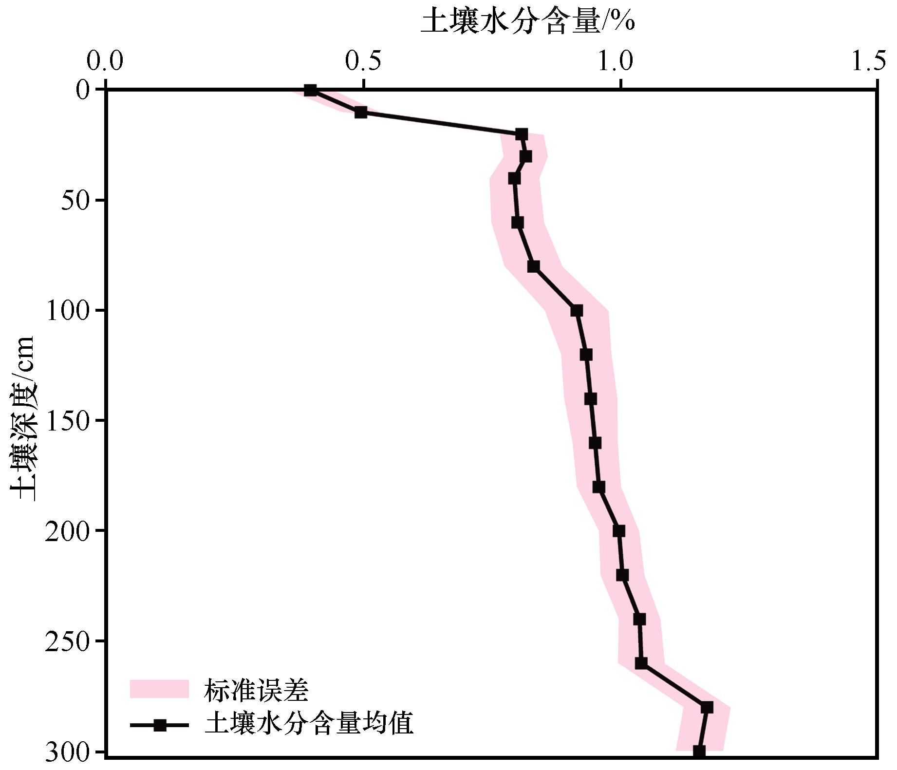
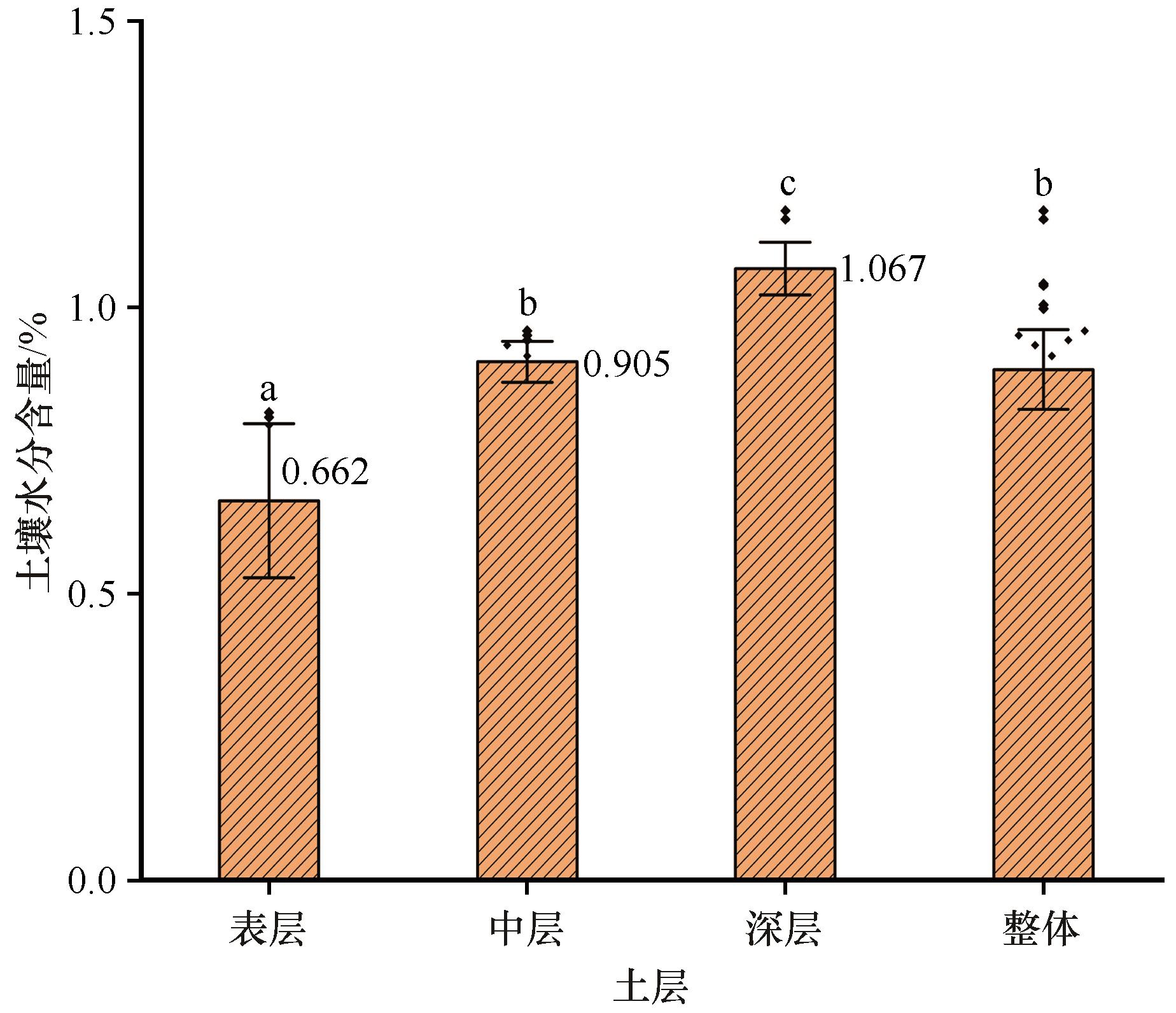
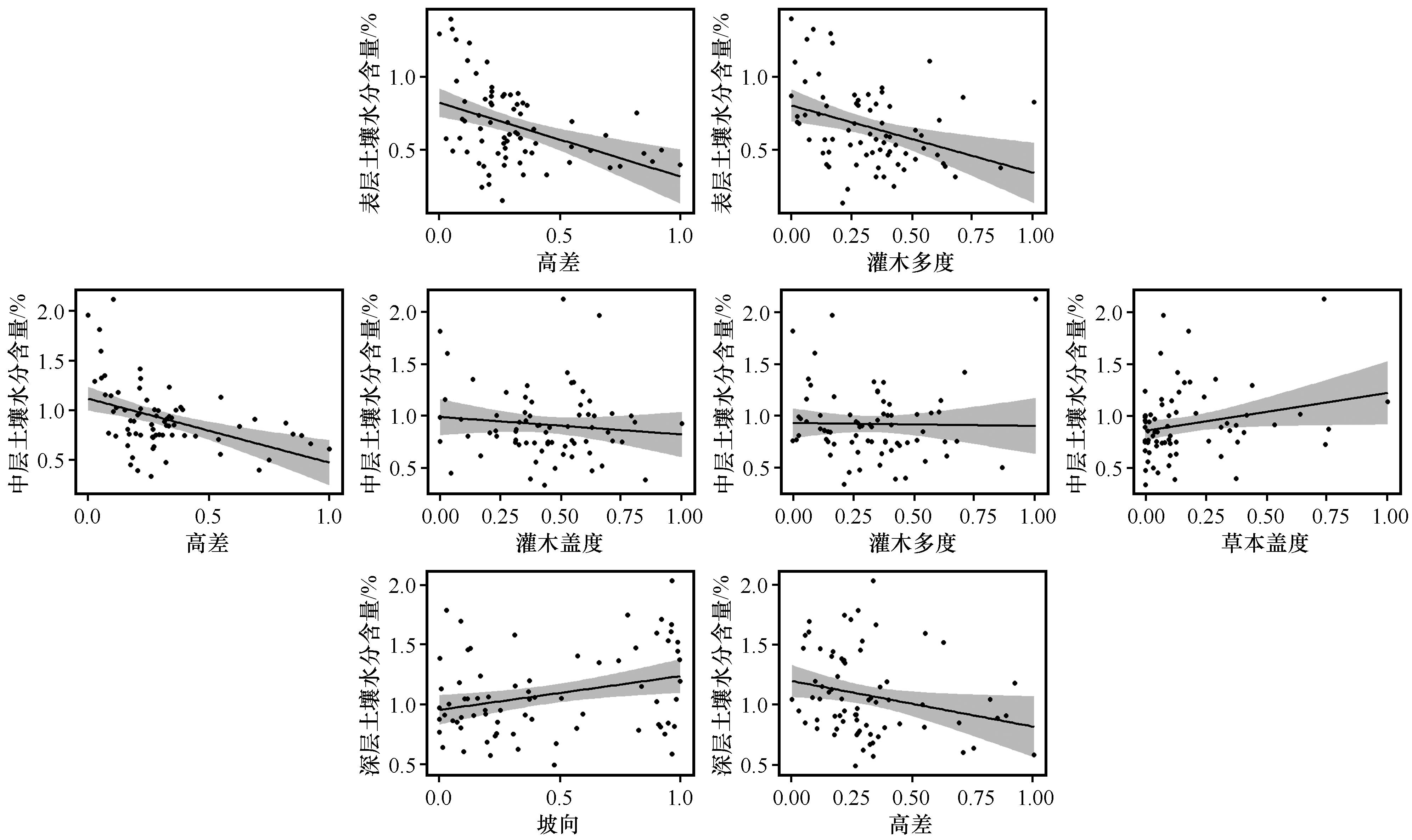
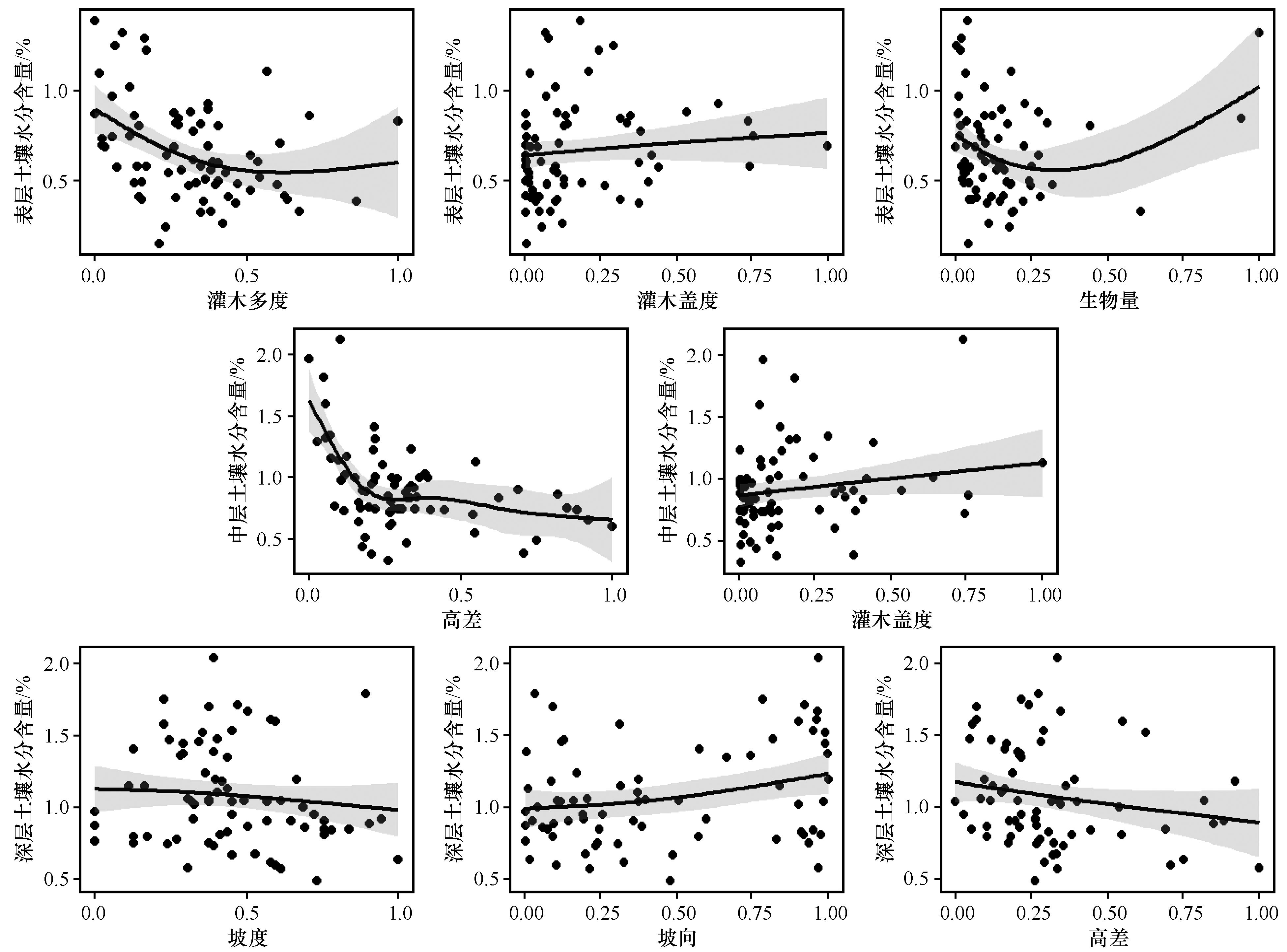
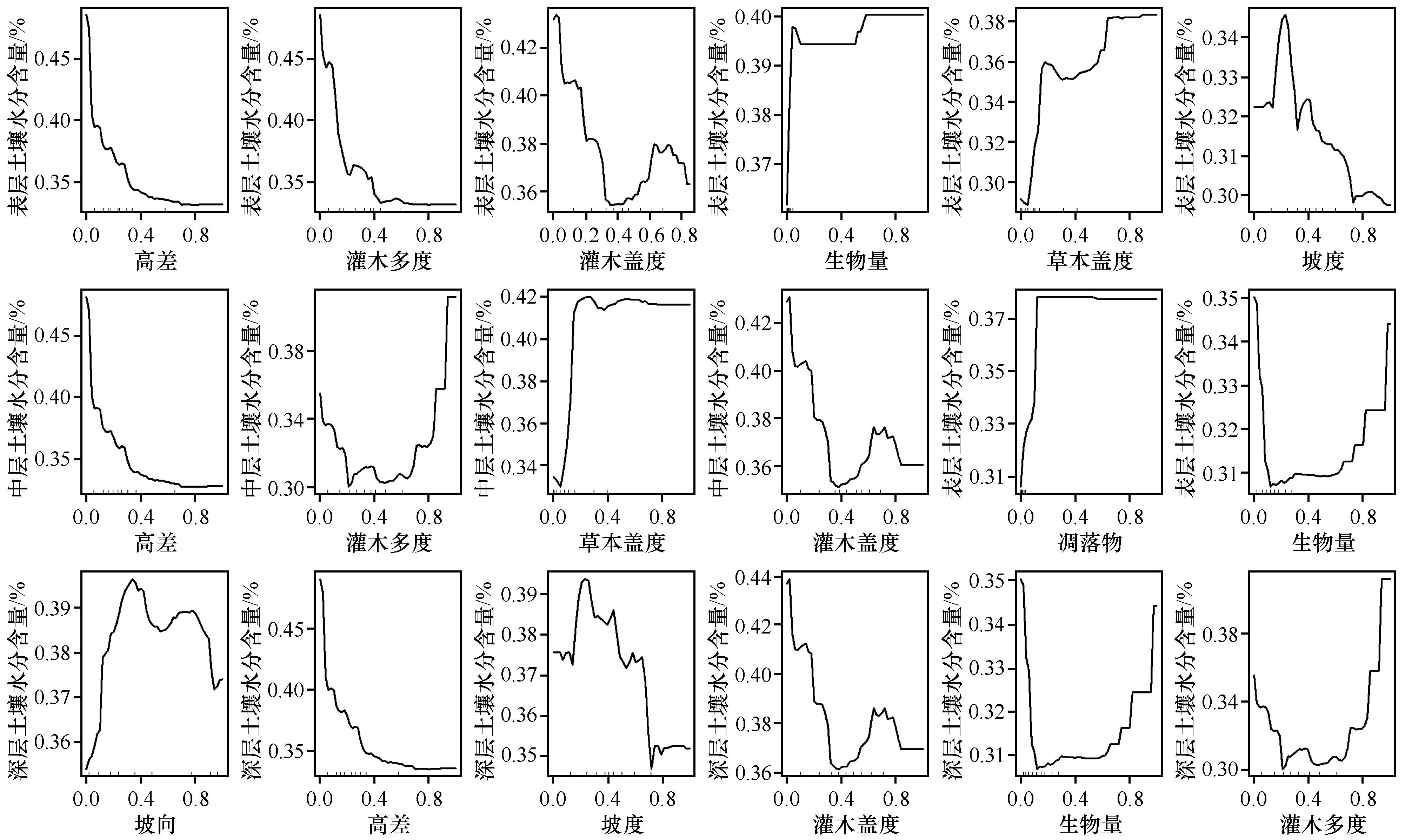
土壤水分是限制固沙植物生长的重要因子。研究沙区土壤水分的分布规律及其与地形、植被的关系,可为荒漠化治理提供科学依据。以腾格里沙漠天然植被区红卫固定沙丘上的土壤水分为研究对象,应用广义线性(GLM)、广义加性(GAM)和随机森林(RF)模型对地形、植被因子对不同深度土壤水分含量的影响进行研究。结果显示:0~300 cm土层可分为表层(0~40 cm)、中层(40~200 cm)和深层(200~300 cm),且三层之间有显著差异。RF模型的精度显著优于GLM和GAM模型。RF模型结果显示,不同深度下土壤水分随地形因子高差增加而逐渐减少。表层和中层土壤水分随草本盖度增加而逐渐增加,而中层和深层土壤水分随灌木多度和生物量的增加呈现先减少后增加的趋势。建议今后在植物固沙过程中,可通过合理控制固沙灌木与草本植被的密度与位置以促进研究区固沙植被的恢复。

关键词: 土壤水分, 地形、植被因子, 广义线性模型, 广义加性模型, 随机森林模型

Abstract:

Soil moisture critically limits the growth of sand-binding vegetation.Analysis of soil moisture distribution patterns in sandy areas, and their correlation with topography and vegetation factors, provides a scientific basis for desertification control. This study focuses on soil moisture in fixed sand dunes within the Hongwei natural vegetation area of the Tengger Desert. Employing methodologies including generalized linear models (GLM), generalized additive models (GAM), and random forest (RF), the research explores the impacts of topography and vegetation factors on soil moisture at various depths. Findings indicate distinct layers within the 0-300 cm soil depth, specifically a surface layer (0-40 cm), a middle layer (40-200 cm), and a deep layer (200-300 cm), each showing significant differences. The RF model exhibits superior accuracy compared to the GLM and GAM models, suggesting that soil moisture decreases with increasing differences in terrain height. Moreover, surface and middle soil moisture levels rise with higher herbaceous coverage, while middle and deep soil moisture levels initially decrease and then increase with greater shrub abundance and biomass. The study suggests that future revegetation and sand fixation efforts should focus on controlling the density and placement of sand-binding shrubs and herbaceous plants to facilitate the restoration of sand-binding vegetation in the study area.

Key words: soil moisture, topography and vegetation factors, generalized linear model, generalized additive model, random forest model

中图分类号: