| [1] |
Dong Z B, Hu G Y, Qian G Q,et al.High-altitude aeolian research on the Tibetan Plateau[J].Reviews of Geophysics,2017,55(4):864-901.
|
| [2] |
Pearce K I, Walker I J.Frequency and magnitude biases in the ‘Fryberger’ model,with implications for characterizing geomorphically effective winds[J].Geomorphology,2005,68(1):39-55.
|
| [3] |
Xie S B, Qu J J, Lai Y M,et al.Formation mechanism and suitable controlling pattern of sand hazards at Honglianghe River section of Qinghai-Tibet Railway[J].Natural Hazards,2015,76(2):855-871.
|
| [4] |
Hu Z H, Gao X, Lei J Q,et al.Geomorphology of aeolian dunes in the western Sahara Desert[J].Geomorphology,2021,392:107916.
|
| [5] |
马芳,吕萍,曹敏,等.柴达木盆地新月形和穹状沙丘共存形态和成因[J].中国沙漠,2025,45(1):185-194.
|
| [6] |
潘加朋,张克存,安志山,等.风沙治理工程综合效益分析:以敦煌黑山嘴风沙口为例[J].中国沙漠,2023,43(2):233-242.
|
| [7] |
Abbasi H, Gohardoust A, Mohammadpour F,et al.Erosive wind characteristics and aeolian sediment transport and dune formation in Makran Region of Baluchistan,Iran[J].Atmosphere,2025,16(6):650.
|
| [8] |
Sadid N.Sand dune migration and flux into the lower Helmand and Arghandab valleys[J].Sedimentologika,2024,2(1).
|
| [9] |
张令光,沈才生,黄艳丽,等.雅鲁藏布江流域输沙势空间特征[J].中国沙漠,2025,45(1):304-317.
|
| [10] |
Hu G Y, Dong Z B, Zhang Z C,et al.Wind regime and aeolian landforms on the eastern shore of Qinghai Lake,Northeastern Tibetan Plateau,China[J].Journal of Arid Environments,2021,188:104451.
|
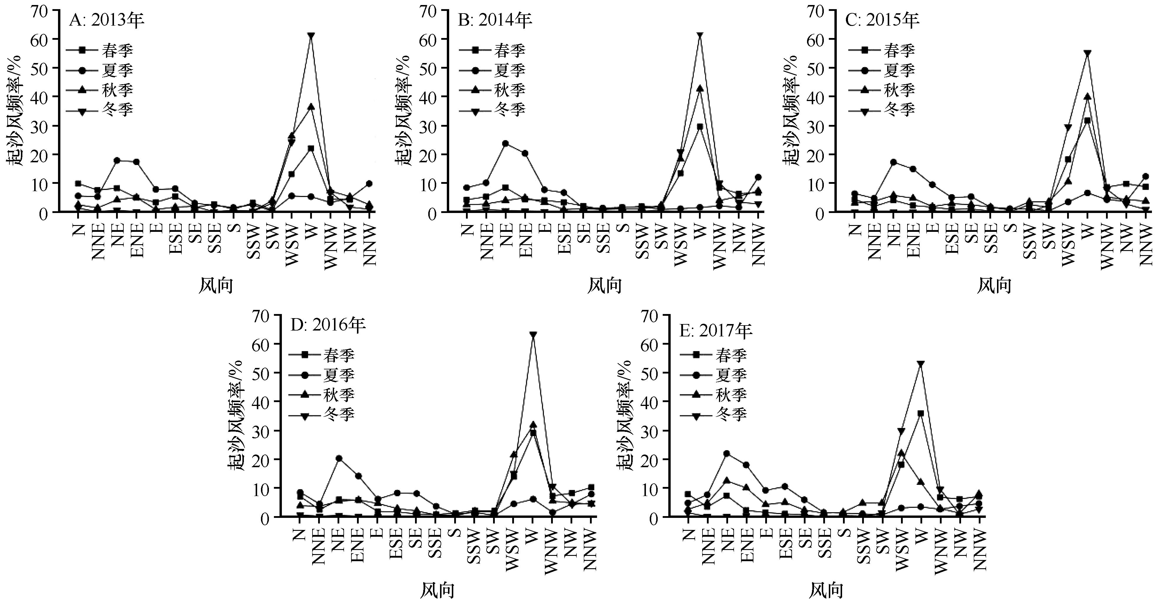
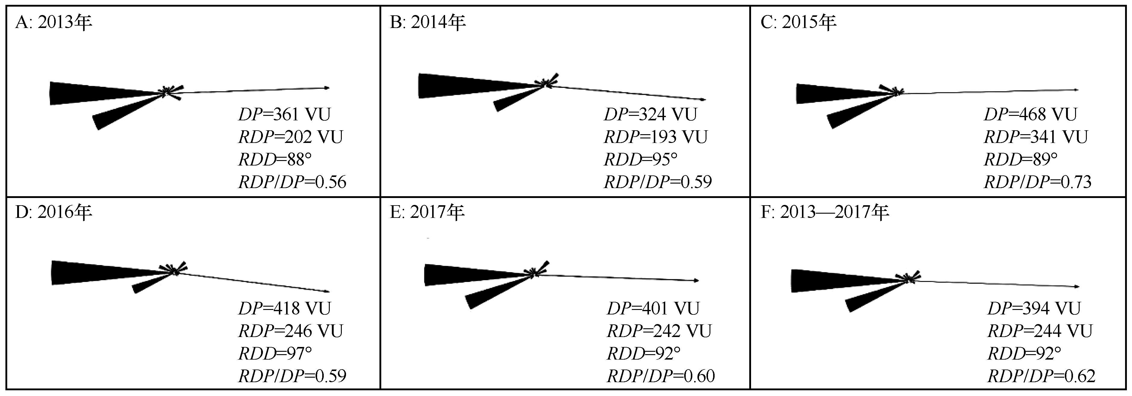
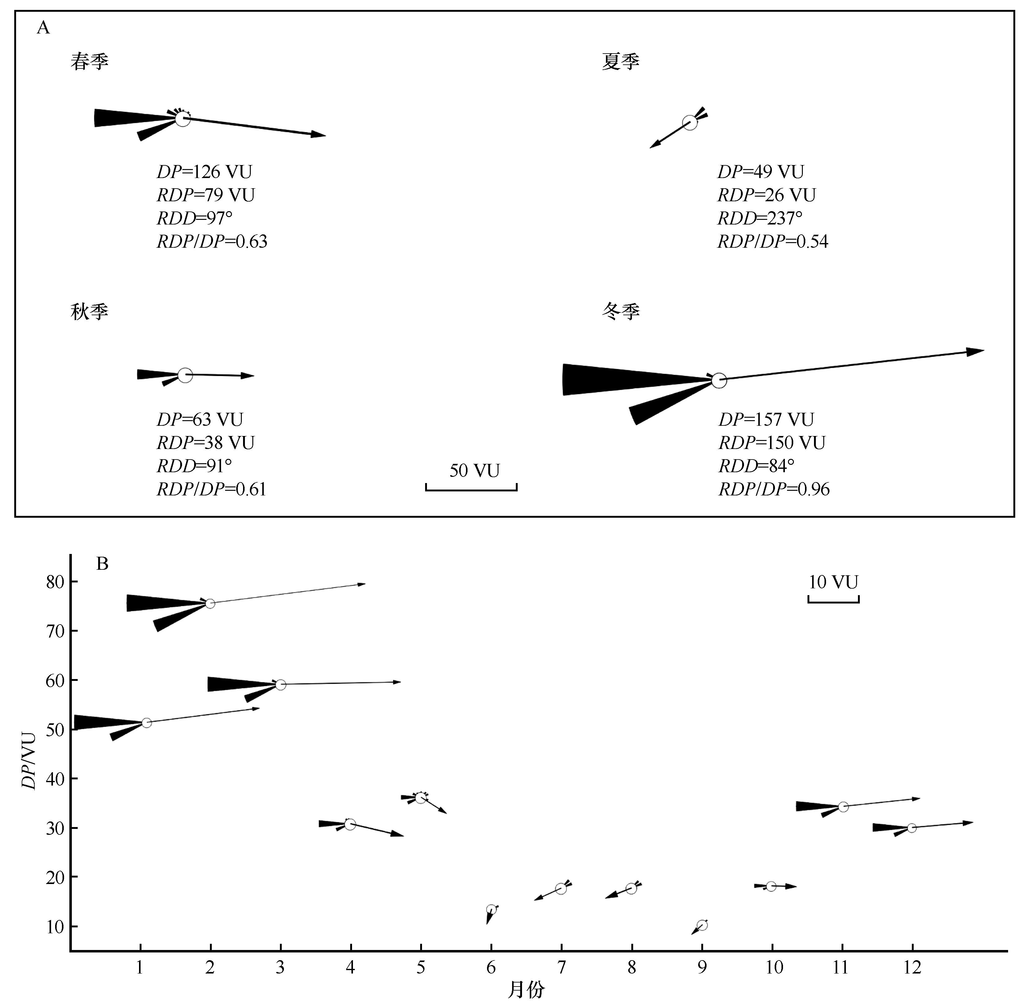
| [11] |
Tao W.Aeolian desertification and its control in Northern China[J].International Soil and Water Conservation Research,2014,2(4):34-41.
|
| [12] |
Zhang C L, Li Q, Shen Y P,et al.Monitoring of aeolian desertification on the Qinghai-Tibet Plateau from the 1970s to 2015 using Landsat images[J].Science of The Total Environment,2018,619/620:1648-1659.
|
| [13] |
Minola L, Zhang G F, Ou T H,et al.Climatology of near-surface wind speed from observational,reanalysis and high-resolution regional climate model data over the Tibetan Plateau[J].Climate Dynamics,2024,62(2):933-953.
|
| [14] |
Chen F H, Zhang J F, Liu J B,et al.Climate change,vegetation history,and landscape responses on the Tibetan Plateau during the Holocene:a comprehensive review[J].Quaternary Science Reviews,2020,243:106444.
|
| [15] |
唐道斌,杨坤美,曾兰华,等.1.5 ka以来青藏高原东北部风沙活动增强的时空差异[J].地理学报,2023,78(9):2284-2298.
|
| [16] |
Hu J J, Hu G Y, Yang L H,et al.Periglacial aeolian activities in the Headwater Region of the Yellow River,northeastern Tibetan Plateau[J].Palaeogeography,Palaeoclimatology,Palaeoecology,2025,671:112984.
|
| [17] |
青藏高原风沙地貌图集[M].西安:西安地图出版社,2017.
|
| [18] |
朱刚,高会军,曾光.近45 a来黄河源区沙质荒漠化土地景观格局变化[J].干旱区资源与环境,2021,35(12):79-85.
|
| [19] |
Hu G Y, Jin H J, Dong Z B,et al.Driving forces of aeolian desertification in the source region of the Yellow River:1975-2005[J].Environmental Earth Sciences,2013,70(7):3245-3254.
|
| [20] |
Dörwald L, Lehmkuhl F, Delobel L,et al.Dune behavior in the Source Area of the Yellow River under climate changes observed from various remote sensing datasets[J].Aeolian Research,2024,67/69:100928.
|
| [21] |
胡光印,董治宝,逯军峰,等.黄河流域沙漠化空间格局与成因[J].中国沙漠,2021,41(4):213-224.
|
| [22] |
胡菁菁,胡光印,董治宝.黄河源区玛多盆地沙漠化土地粒度特征[J].中国沙漠,2022,42(4):242-252.
|
| [23] |
孟宪红,吕世华.鄂陵湖流域湖畔观测点常规气象观测数据[DS/OL].国家冰川冻土沙漠科学数据中心,2022..
|
| [24] |
吴正,等.风沙地貌与治沙工程学[M].北京:科学出版社,2003.
|
| [25] |
Qian G Q, Yang Z L, Xing X G,et al.Seasonal morphological evolution and migration of granule ripples in the Sanlongsha Dune Field,northern Kumtagh Sand Sea,China[J].Geomorphology,2024,444:108951.
|
| [26] |
Fryberge S G.Dune forms and wind regime[M]//Dune Forms and Wind Regime.Washington,D.C.USA:United States Government Printing Office,1979:137-169.
|
| [27] |
Zhang G F, Azorin-Molina C, Chen D L,et al.Variability and trends of near-surface wind speed over the Tibetan Plateau:the role played by the westerly and Asian monsoon[J].Advances in Climate Change Research,2024,15(3):525-536.
|
| [28] |
Wasson R J, Hyde R.Factors determining desert dune type[J].Nature,1983,304(5924):337-339.
|
| [29] |
董治宝,钱广强.关于土壤水分对风蚀起动风速影响研究的现状与问题[J].土壤学报,2007(5):934-942.
|
| [30] |
胡光印,董治宝,张正偲,等.若尔盖盆地起沙风风况与输沙势特征[J].中国沙漠,2020,40(5):20-24.
|
| [31] |
谢胜波,喻文波,屈建军,等.青藏高原红梁河风沙动力环境特征[J].中国沙漠,2018,38(2):219-224.
|
| [32] |
陈宗颜,董治宝,汪青春.青海共和盆地风况及风沙地貌[J].中国沙漠,2018,38(3):492-499.
|
| [33] |
卢佳雪,刘雅丹,王学林,等.雅鲁藏布江干旱河谷米林段风况及输沙势特征[J].干旱区资源与环境,2025,39(4):145-155.
|
| [34] |
张可盈,张娴,谢胜波.柳格高速公路沿线风沙环境特征[J].中国沙漠,2025,45(5):277-288.
|
| [35] |
陈宗颜,董治宝,汪青春,等.柴达木盆地风况及输沙势特征[J].中国沙漠,2020,40(1):195-203.
|
| [36] |
王涛,谢胜波,屈建军,等.通天河七渡口风沙环境特征及沙害防治[J].中国沙漠,2019,39(2):70-78.
|
| [37] |
蔡迪文,张克存,安志山,等.青藏铁路格拉段风动力环境及其对铁路沙害的影响[J].中国沙漠,2017,37(1):40-47.
|
| [38] |
Xie S B, Qu J J, Xu X T,et al.Interactions between freeze-thaw actions,wind erosion desertification,and permafrost in the Qinghai-Tibet Plateau[J].Natural Hazards,2017,85(2):829-850.
|
| [39] |
Xue X, Guo J, Han B W,et al.The effect of climate warming and permafrost thaw on desertification in the Qinghai-Tibetan Plateau[J].Geomorphology,2009,108(3):182-190.
|
 ), 胡光印(
 甘公网安备 62010202000688号