| [1] |
D'Almeida G A.A model for Saharan dust transport[J].Journal of Applied Meteorology,1986,25(7):903-916.
|
| [2] |
Du H Q, Wang T, Xue X,et al.Modelling of sand/dust emission in Northern China from 2001 to 2014[J].Geoderma,2018,330:162-176.
|
| [3] |
Gillette D A, Hanson K J.Spatial and temporal variability of dust production caused by wind erosion in the United States[J].Journal of Geophysical Research Atmospheres,1989,94(D2):2197-2206.
|
| [4] |
景可,陈永宗.我国土壤侵蚀与地理环境的关系[J].地理研究,1990,9(2):29-38.
|
| [5] |
Roskin J, Porat N, Tsoar H,et al.Age,origin and climatic controls on vegetated linear dunes in the northwestern Negev Desert(Israel)[J].Quaternary Science Reviews,2011,30(13):1649-1674.
|
| [6] |
Zhang Z C, Pan K J, Zhang C X,et al.Geochemical characteristics and the provenance of aeolian material in the Hexi Corridor Desert,China[J].CATENA,2020,190:104483.
|
| [7] |
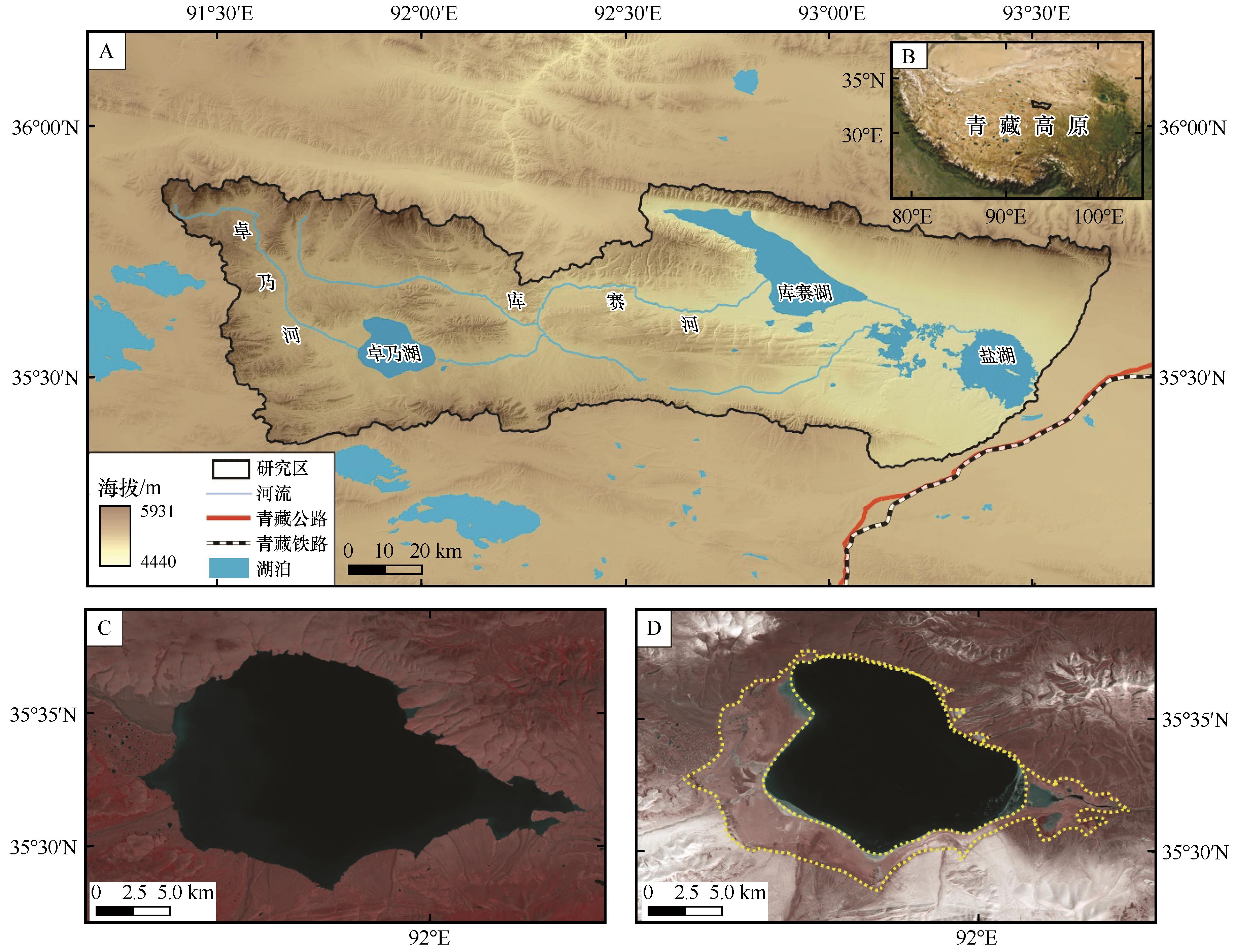
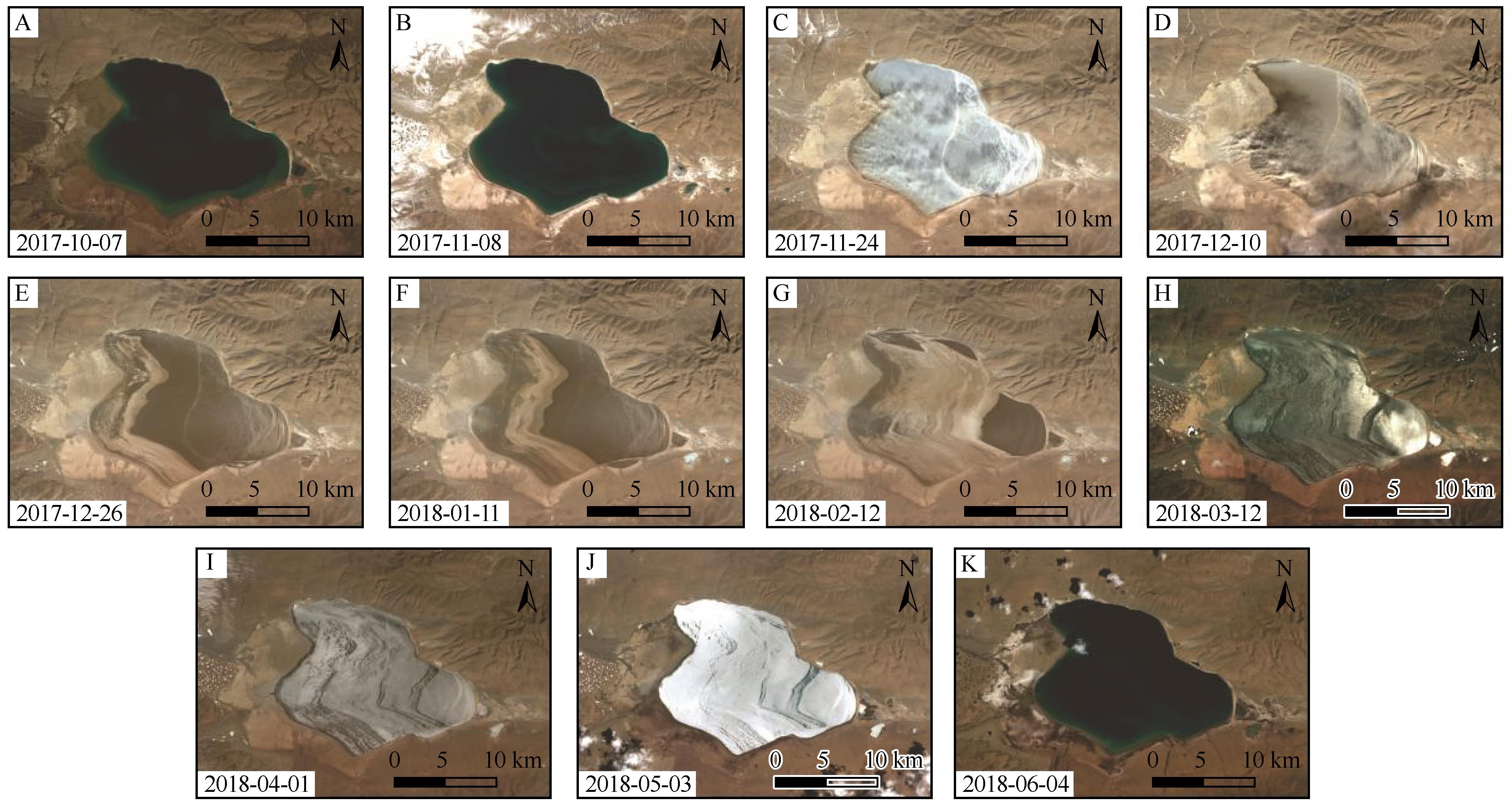
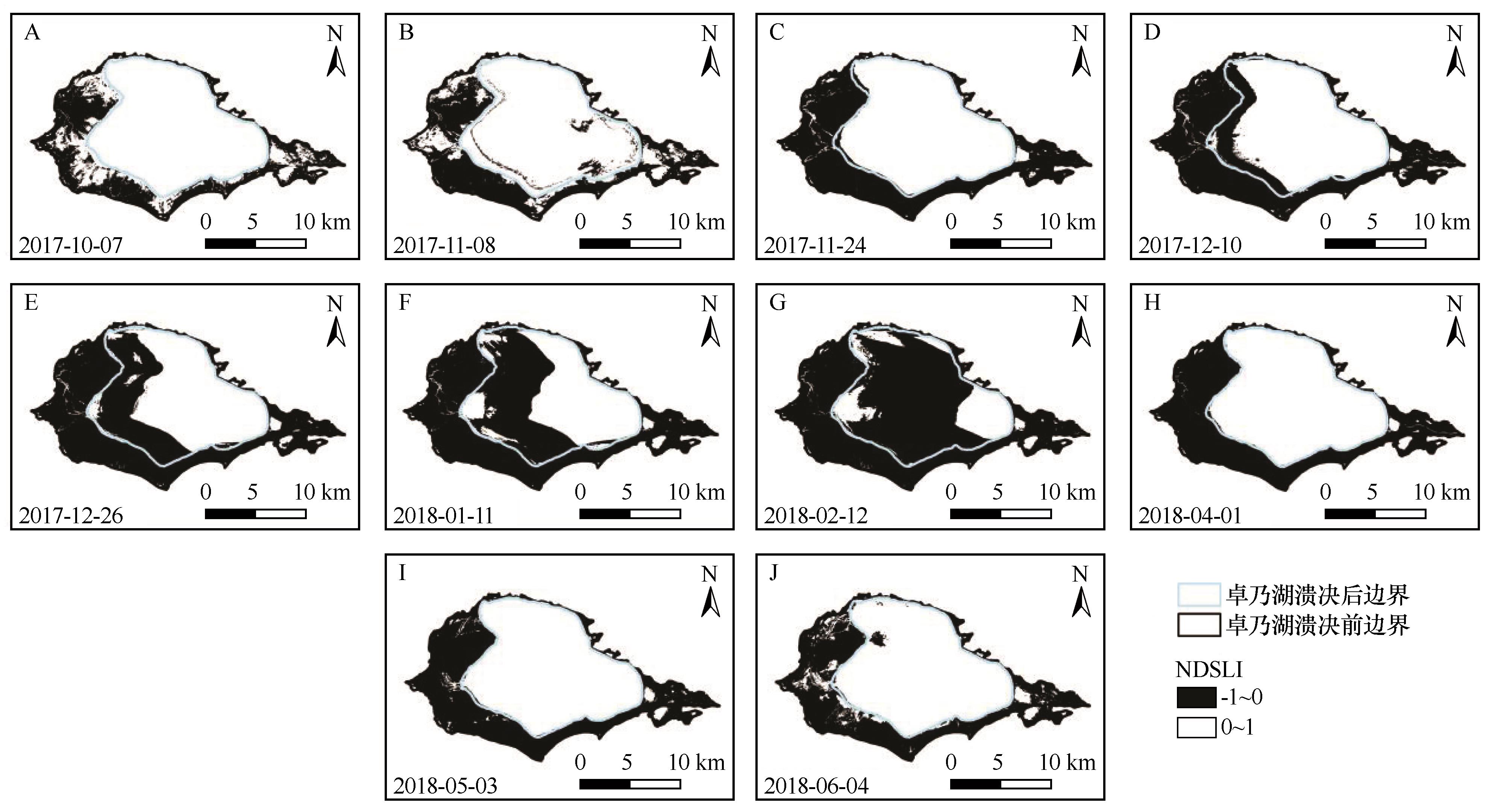
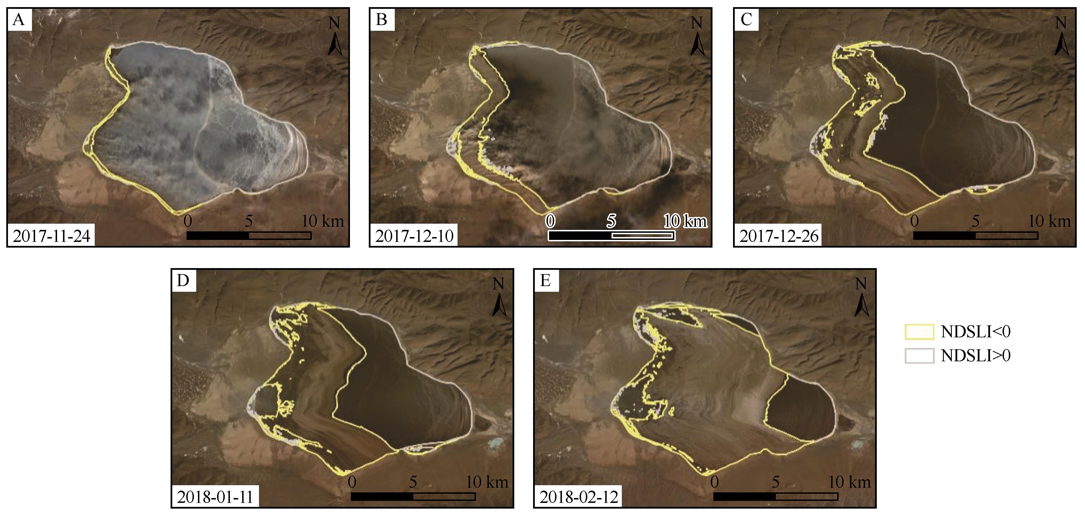
范亚伟,杜鹤强,卢善龙,等.长江源卓乃湖流域沙尘释放过程模拟[J].地理科学,2023,43(12):2247-2256.
|
| [8] |
刘东伟,吉力力·阿不都外力,穆桂金,等.艾比湖干涸湖底化学组成及盐尘的风运堆积[J].中国环境科学,2009,29(2):157-162.
|
| [9] |
于海云,张正偲,王志军.阿拉善高原东南部干涸湖盆沉积物粒度特征[J].中国沙漠,2021,41(4):177-184.
|
| [10] |
Muhs D R, Reynolds R L, Been J,et al.Eolian sand transport pathways in the southwestern United States:importance of the Colorado River and local sources[J].Quaternary International,2003,104(1):3-18.
|
| [11] |
Draut A E.Effects of river regulation on aeolian landscapes,Colorado River,southwestern USA[J].Journal of Geophysical Research,2012,117(F2):F02022.
|
| [12] |
Du H Q, Wang T, Xue X,et al.Modern eolian and fluvial processes and their interactions in an ephemeral desert stream in Inner Mongolia,China[J].Journal of Soils and Sediments,2019,20(2):1140-1156.
|
| [13] |
Hu G Y, Hu J J, Dong Z B,et al.Seasonal ice-covered lake surface likely caused the spatial heterogeneity of aeolian sediment grain-size in the source region of Yellow River,northeastern Tibetan Plateau,China[J].Frontiers in Earth Science,2023,1150585.
|
| [14] |
段安民,肖志祥,吴国雄.1979-2014年全球变暖背景下青藏高原气候变化特征[J].气候变化研究进展,2016,12(5):374-381.
|
| [15] |
张国庆.青藏高原湖泊变化遥感监测及其对气候变化的响应研究进展[J].地理科学进展,2018,37(2):214-223.
|
| [16] |
Lu S L, Chen F, Zhou J F,et al.Cascading implications of a single climate change event for fragile ecosystems on the Qinghai-Tibetan Plateau[J].Ecosphere,2020,11(9):e03243.
|
| [17] |
Liu B K, Du Y, Li L,et al.Outburst flooding of the moraine-dammed Zhuonai Lake on Tibetan Plateau:causes and impacts[J].IEEE Geoscience and Remote Sensing Letters,2016,23(4):570-574.
|
| [18] |
Lu S L, Jin J M, Zhou J F,et al.Drainage basin reorganization and endorheic-exorheic transition triggered by climate change and human intervention[J].Global and Planetary Change,2021,201:103494.
|
| [19] |
谢昌卫,张钰鑫,刘文惠,等.可可西里卓乃湖溃决后湖区环境变化及盐湖可能的溃决方式[J].冰川冻土,2020,42(4):1344-1352.
|
| [20] |
姚晓军,刘时银,孙美平,等.可可西里地区库赛湖变化及湖水外溢成因[J].地理学报,2012,67(5):689-698.
|
| [21] |
白虎志,董安祥,李栋梁,等.青藏高原及青藏铁路沿线大风沙尘日数时空特征[J].高原气象,2005(3):311-315.
|
| [22] |
Dong Z B, Hu G Y, Qian G Q,et al.High-altitude aeolian research on the Tibetan Plateau[J].Reviews of Geophysics,2017,55(4):864-901.
|
| [23] |
Fadhil A M.Sand dunes monitoring using remote sensing and GIS techniques for some sites in Iraq[C]//Proceedings of SPIE:The International Society for Optical Engineering.2013:8762.
|
| [24] |
Fadhil A M.Land degradation detection using geo-information technology for some sites in Iraq[J].Journal of AlNahrain University-Science,2009,12(3):94-108.
|
| [25] |
Deng Y B, Wu C S, Li M,et al.RNDSI:a ratio normalized difference soil index for remote sensing of urban/suburban environments[J].International Journal of Applied Earth Observation and Geoinformation,2015,39:40-48.
|
| [26] |
Pan X, Zhu X, Yang Y B,et al.Applicability of downscaling land surface temperature by using normalized difference sand index[J].Scientific Reports,2018,8(1):1-14.
|
| [27] |
Sahar A A, Alhadithi A A, Hassan M A,et al.Integrated remote sensing and GIS for developed new spectral index for estimating Sandy land and its potential hazards.case study:North-east Al-Muthanna Province area,South of Iraq[J].Arabian Journal of Geosciences,2021,14(3):191.
|
| [28] |
Liu W H, Xie C W, Zhao L,et al.Dynamic changes in lakes in the Hoh Xil region before and after the 2011 outburst of Zonag Lake[J].Journal of Mountain Science,2019:1098-1110.
|
| [29] |
Hu Z K, Tan D B, Wen X F,et al.Investigation of dynamic lake changes in Zhuonai Lake-Salt Lake Basin,Hoh Xil,using remote sensing images in response to climate change(1989-2018)[J].Journal of Water and Climate Change,2021,12(6):2199-2216.
|
| [30] |
Zhang Z J, Wang M M, Liu X G,et al.Map and quantify the ground deformation around salt lake in Hoh Xil,Qinghai-Tibet Plateau using time-series InSAR from 2006 to 2018[J].IEEE Journal of Selected Topics in Applied Earth Observations and Remote Sensing,2021,14:858-869.
|
| [31] |
Ding Z K, Niu F J, Li G Y,et al.The outburst of a lake and its impacts on redistribution of surface water bodies in high-altitude permafrost region[J].Remote Sensing,2022,14(12):2918.
|
| [32] |
Guo L N, Zheng H X, Wu Y H,et al.An integrated dataset of daily lake surface water temperature over Tibetan Plateau[J].Earth System Science Data,2022,14:3411-3422.
|
 ), 胡光印(
 甘公网安备 62010202000688号