| [1] |
余东华,张明志.“异质性难题”化解与碳排放EKC再检验:基于门限回归的国际分组研究[J].中国工业经济,2016(7):57-73.
|
| [2] |
郭利京,黄振英.淮河生态经济带农业面源污染空间分布及治理研究[J].长江流域资源与环境,2021,30(7):1746-1756.
|
| [3] |
刘静,路凤,杨延钊,等.南四湖农业面源污染现状及控制措施[J].中国人口·资源与环境,2011,21(S1):292-295.
|
| [4] |
Abler D.Economic evaluation of agricultural pollution control options for China[J].Journal of Integrative Agriculture,2015,14(6):1045-1056.
|
| [5] |
徐丽萍,杨其军,王玲,等.新疆地区农业面源污染空间分异研究[J].水土保持通报,2011,31(4):150-153.
|
| [6] |
邢铭强,马可,陈彩亮,等.河西地区农业绿色发展水平测度及耦合协调提升路径[J].中国沙漠,2024,44(6):207-219.
|
| [7] |
夏文浩,潘生亮,霍瑜,等.新疆农业面源污染的时空分异及动态演进:基于特色畜牧视角的再分析[J].资源开发与市场,2022,38(10):1190-1199.
|
| [8] |
第二次全国污染源普查公报[J].环境保护,2020,48(18):8-10.
|
| [9] |
赖斯芸,杜鹏飞,陈吉宁.基于单元分析的非点源污染调查评估方法[J].清华大学学报(自然科学版),2004(9):1184-1187.
|
| [10] |
谢培,宫健,陈诚.北京市农业面源污染负荷特征分析及控制分区[J].环境工程技术学报,2020,10(4):613-622.
|
| [11] |
陈敏鹏,陈吉宁,赖斯芸.中国农业和农村污染的清单分析与空间特征识别[J].中国环境科学,2006(6):751-755.
|
| [12] |
李光勤,牛雯琦,王江姣.黄河流域农业面源污染的演化特征与区域差异[J].中国沙漠,2024,44(6):146-154.
|
| [13] |
陈武权,杨庆榜,杨斌.基于产排污系数法的鄱阳湖滨湖区总磷排放量测算研究[J].环境污染与防治,2022,44(7):960-965.
|
| [14] |
董红敏,朱志平,黄宏坤,等.畜禽养殖业产污系数和排污系数计算方法[J].农业工程学报,2011,27(1):303-308.
|
| [15] |
郭玉静,李红兵,王树明,等.滇中高原水库外源污染负荷贡献解析与环境容量核算[J].环境科学,2023,44(3):1508-1518.
|
| [16] |
陈晓丽,雷勇,黄国如.北江飞来峡库区流域非点源污染现状评价[J].水资源保护,2019,35(2):44-48+53.
|
| [17] |
丘丽清,吴根义,李想,等.基于等标污染负荷强度的海南省农村面源污染特征研究[J].农业资源与环境学报,2023,40(1):55-63.
|
| [18] |
赖诗琪,安敏,安慧,等.长江经济带地级市农业面源污染来源解析[J].中国农业资源与区划,2025,46(5):63-73.
|
| [19] |
付意成,臧文斌,董飞,等.基于SWAT模型的浑太河流域农业面源污染物产生量估算[J].农业工程学报,2016,32(8):1-8.
|
| [20] |
李威,赵祖伦,吕思思,等.基于InVEST模型的水质净化功能时空分异研究[J].灌溉排水学报,2022,41(3):105-113.
|
| [21] |
杨金凤,冯爱萍,王雪蕾,等.海河流域农业面源污染潜在风险识别方法[J].中国环境科学,2021,41(10):4782-4791.
|
| [22] |
逯颖,张建辉,李文君,等.长江经济带农业面源总磷污染时空特征分析[J].农业环境科学学报,2024,43(12):2752-2764.
|
| [23] |
周晓琴,杨乐,杨令飞.新疆农业面源污染物排放量估算及分析[J].农业环境科学学报,2017,36(7):1300-1307.
|
| [24] |
杭伟,陆永兴,郭浩,等.西北荒漠区土壤氮素组分沿干旱梯度的空间变化[J].中国沙漠,2024,44(3):259-268.
|
| [25] |
陆忠奇,赵竹君,何清.库尔勒市大气颗粒物浓度特征及来源[J].中国沙漠,2022,42(6):74-84.
|
| [26] |
陈仪,夏立江,于晓勇.农村环境污染识别方法与应用研究[J].农业环境科学学报,2010,29(11):2221-2227.
|
| [27] |
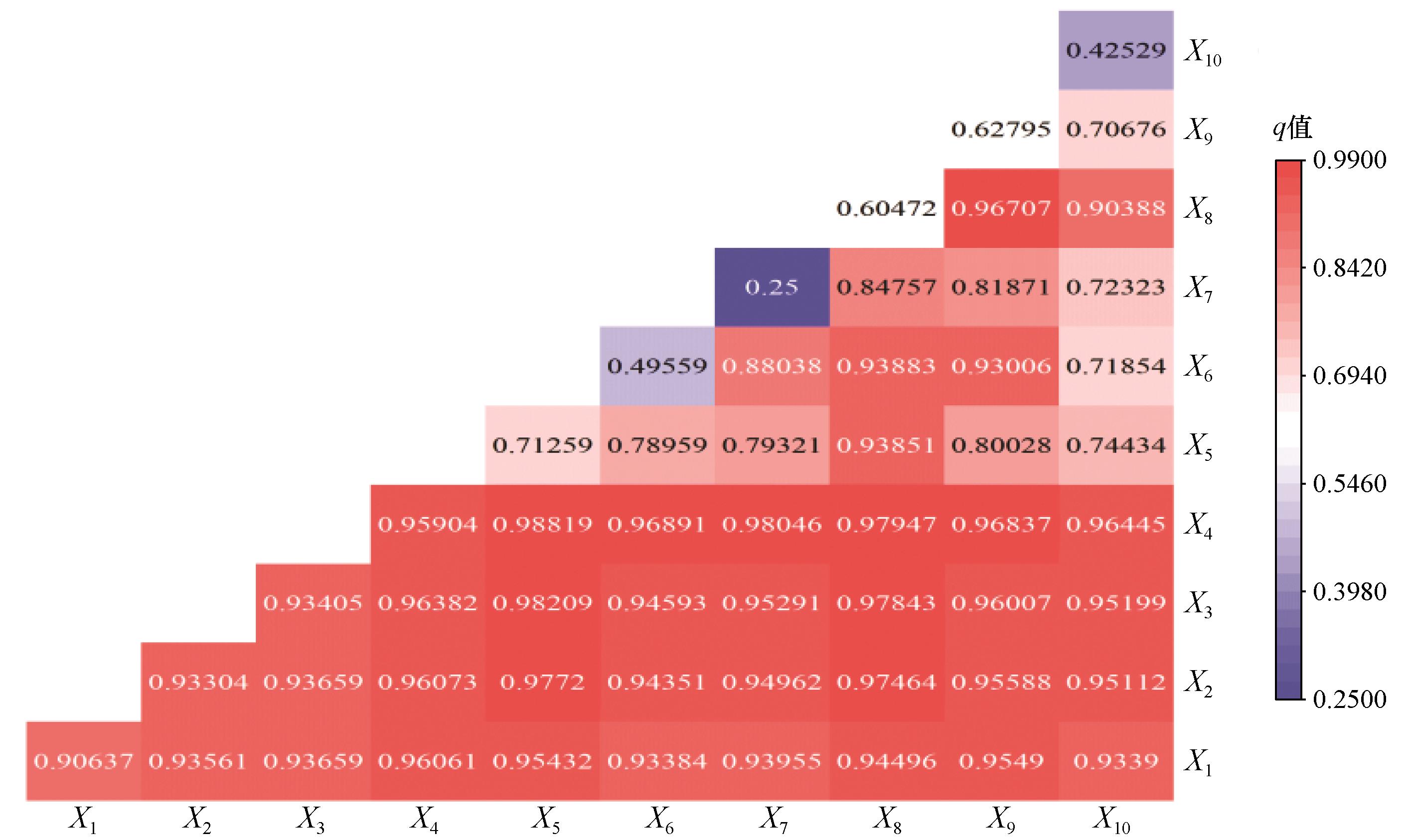
王劲峰,徐成东.地理探测器:原理与展望[J].地理学报,2017,72(1):116-134.
|
| [28] |
刘衡,朱铁辉,辛岭.农业现代化与城乡融合的耦合协调和驱动因素[J].农业现代化研究,2021,42(6):982-995.
|
| [29] |
侯力,阿儒汗.中国区域人口增减的时空演变及驱动因素分析[J].人口学刊,2025,47(3):1-18.
|
| [30] |
科学养鱼.新疆水利资源及水产养殖业概况:新疆水产研究所副所长杜劲松在2012《科学养鱼》通讯发行会上的发言[J].科学养鱼,2012(11):3.
|
| [31] |
聂春霞,孙慧,闫海龙,等.新疆艾比湖流域经济社会水资源配置研究[J].经济地理,2014,34(1):156-160.
|
| [32] |
罗万云,戎铭倩,郭世豪.资源依赖视域下荒漠化地区农户耕地利用效率差异及影响因素研究:基于南疆四地州农户调查数据[J].中国沙漠,2024,44(5):105-115.
|
| [33] |
徐新良.中国月度NDVI、EVI250m数据集.资源环境科学数据注册与出版系统.
|
| [34] |
彭守璋中国1km分辨率月逐月降水量数据集( 1901-2024).国家青藏高原科学数据中心.
|
| [35] |
张淑荣,陈利顶,傅伯杰.农业区非点源污染敏感性评价的一种方法[J].水土保持学报,2001(2):56-59.
|
| [36] |
刘康,欧阳志云,王效科,等.甘肃省生态环境敏感性评价及其空间分布[J].生态学报,2003,23(12):2711-2718.
|
| [37] |
孙才志,杨磊,胡冬玲.基于GIS的下辽河平原地下水生态敏感性评价[J].生态学报,2011,31(24):7428-7440.
|
| [38] |
周亮,徐建刚,孙东琪,等.淮河流域农业非点源污染空间特征解析及分类控制[J].环境科学,2013,34(2):547-554.
|
| [39] |
徐晨曦,万红莲,何若楠,等.关中平原城市群脆弱性时空演变与驱动因子[J].中国沙漠,2023,43(6):111-120.
|
| [40] |
李琛,吴映梅,高彬嫔,等.高原湖泊乡村聚落空间分异及驱动力探测:以环洱海地区为例[J].经济地理,2022,42(4):220-229.
|
| [41] |
潘昌祥,欧阳茜如,廖梦榆,等.西北干旱区沙漠化土地生态修复技术及沙产业的适用范围[J].中国沙漠,2023,43(5):155-165.
|
 ), 晁伟鹏(
 甘公网安备 62010202000688号