中国沙漠 ›› 2022, Vol. 42 ›› Issue (6): 53-64.DOI: 10.7522/j.issn.1000-694X.2022.00042
秦豪君1,2( ), 杨晓军2(), 马莉2, 王一丞2, 傅朝2, 张君霞2, 陆正奇3
收稿日期:2022-01-19
修回日期:2022-04-25
出版日期:2022-11-20
发布日期:2023-01-09
通讯作者:
杨晓军
作者简介:杨晓军(E-mail: 102804685@qq.com)基金资助:
Haojun Qin1,2(), Xiaojun Yang2(), Li Ma2, Yicheng Wang2, Zhao Fu2, Junxia Zhang2, Zhengqi Lu3
Received:2022-01-19
Revised:2022-04-25
Online:2022-11-20
Published:2023-01-09
Contact:
Xiaojun Yang
摘要:
利用地面观测资料分析了2000—2020年中国西北地区区域性沙尘暴特征,同时基于气候动力因子、温度、降水和NDVI资料,研究西北地区区域性沙尘暴成因。结果表明:2000—2020年西北地区区域性沙尘暴年总日数呈波动下降趋势,且存在两个高(低)频期。春季是区域性沙尘暴高发季,其中4月总日数最高,达47 d;相较于上旬和中旬,春季各月下旬更易出现区域性沙尘暴。新疆南部的塔里木盆地、内蒙古中西部和甘肃河西是西北地区区域性沙尘暴高发区,总日数均在10 d以上,其余大部分地方总日数均小于8 d。北半球极涡面积指数、强度指数及亚洲区极涡强度指数均与区域性沙尘暴日数显著正相关,北半球极涡从扩张期到收缩期转变及其强度的减弱,是西北地区区域性沙尘暴减少的重要气候动力因素。西北地区年(春季)降水量和平均NDVI均与区域性沙尘暴日数显著负相关,近21年西北地区大部分地方气候趋于暖湿化,植被覆盖整体以改善为主要趋势,此种转变有利于沙化面积收缩,减少非输入性沙尘暴的发生。
中图分类号:
秦豪君, 杨晓军, 马莉, 王一丞, 傅朝, 张君霞, 陆正奇. 2000—2020年中国西北地区区域性沙尘暴特征及成因[J]. 中国沙漠, 2022, 42(6): 53-64.
Haojun Qin, Xiaojun Yang, Li Ma, Yicheng Wang, Zhao Fu, Junxia Zhang, Zhengqi Lu. Characteristics and causes of regional sandstorms in Northwest of China from 2000 to 2020[J]. Journal of Desert Research, 2022, 42(6): 53-64.
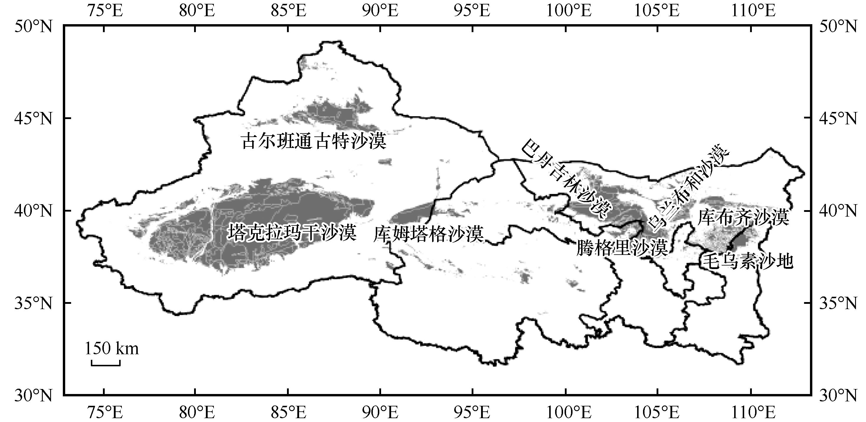
图1 研究区域概况
Fig.1 Overview of the study area
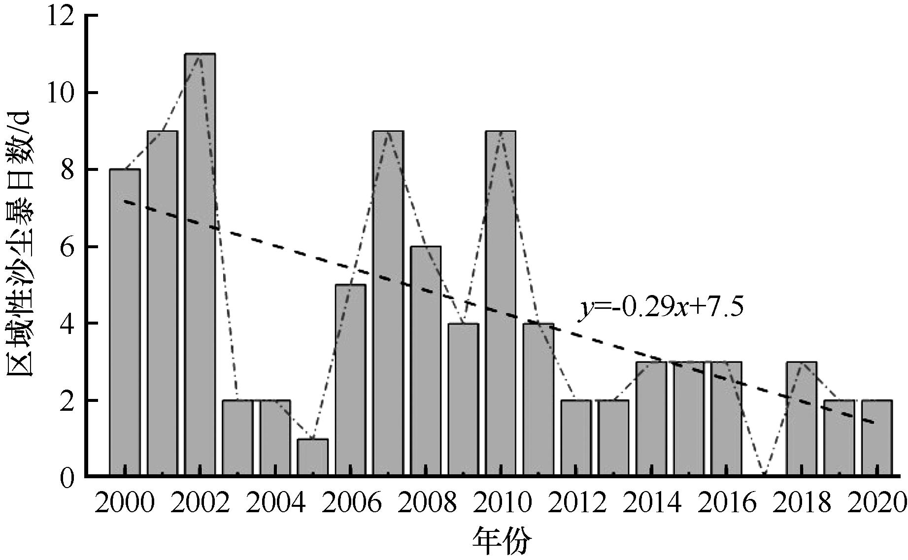
图2 2000—2020年西北地区区域性沙尘暴逐年总日数
Fig.2 The annual total number of days of regional sandstorms in Northwest of China from 2000 to 2020
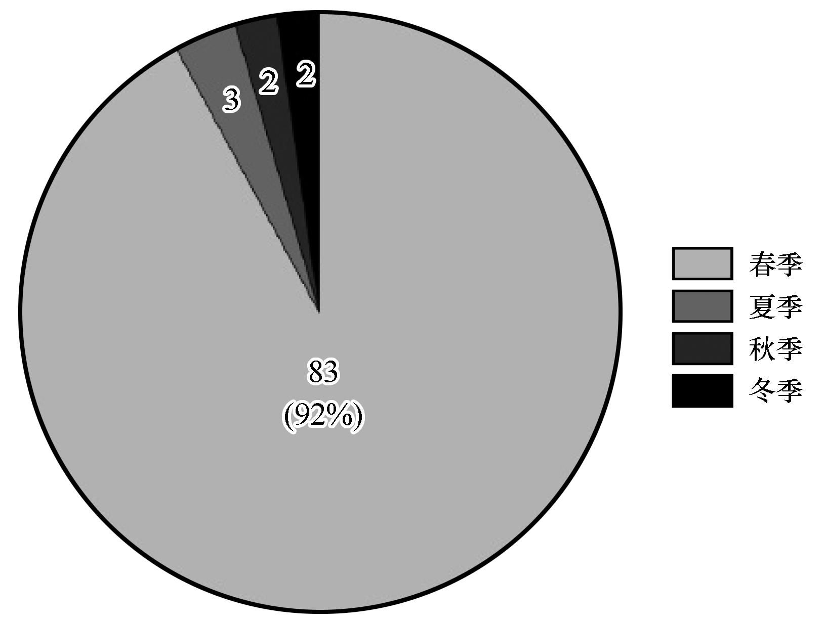
图3 2000—2020年西北地区区域性沙尘暴季节总日数
Fig.3 The season total number of days of regional sandstorm in Northwest of China from 2000 to 2020
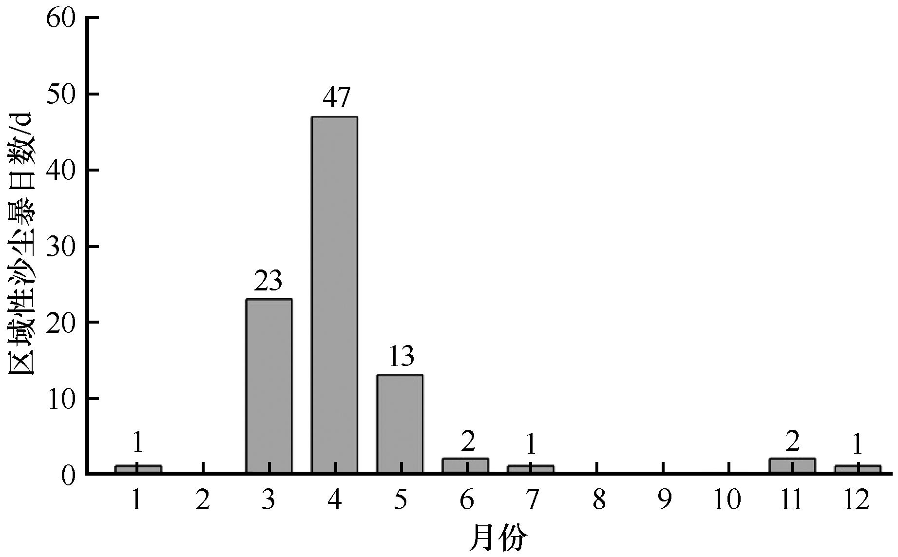
图4 2000—2020年西北地区区域性沙尘暴逐月总日数
Fig.4 The monthly total number of days of regional sandstorms in Northwest of China from 2000 to 2020
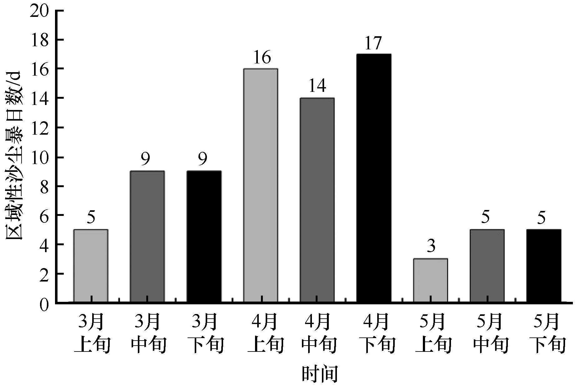
图5 2000—2020年西北地区区域性沙尘暴3—5月各旬总日数
Fig.5 The total number of every ten days of regional sandstorms in Northwest of China from March to May from 2000 to 2020
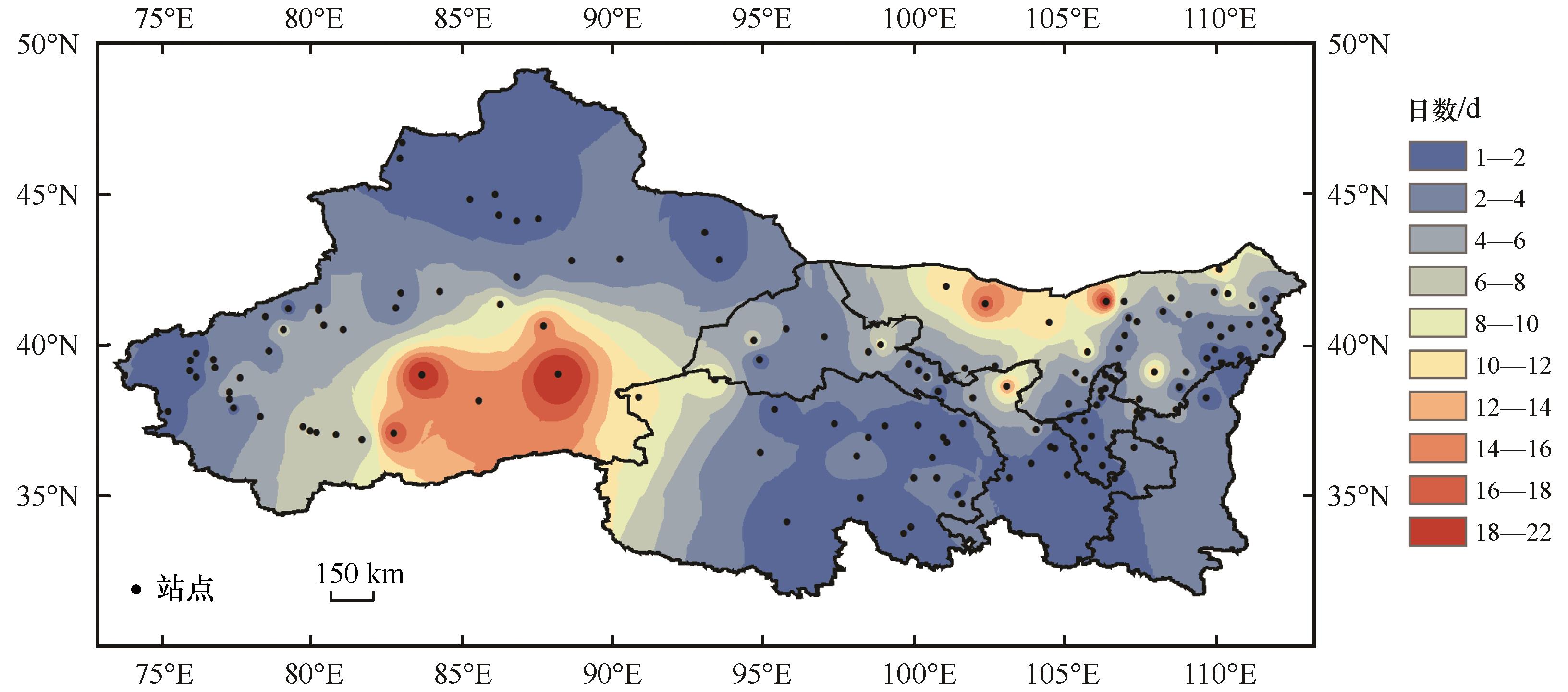
图6 2000—2020年西北地区区域性沙尘暴年总日数空间分布
Fig.6 Spatial distribution of total annual days of regional sandstorms in Northwestern of China from 2000 to 2020
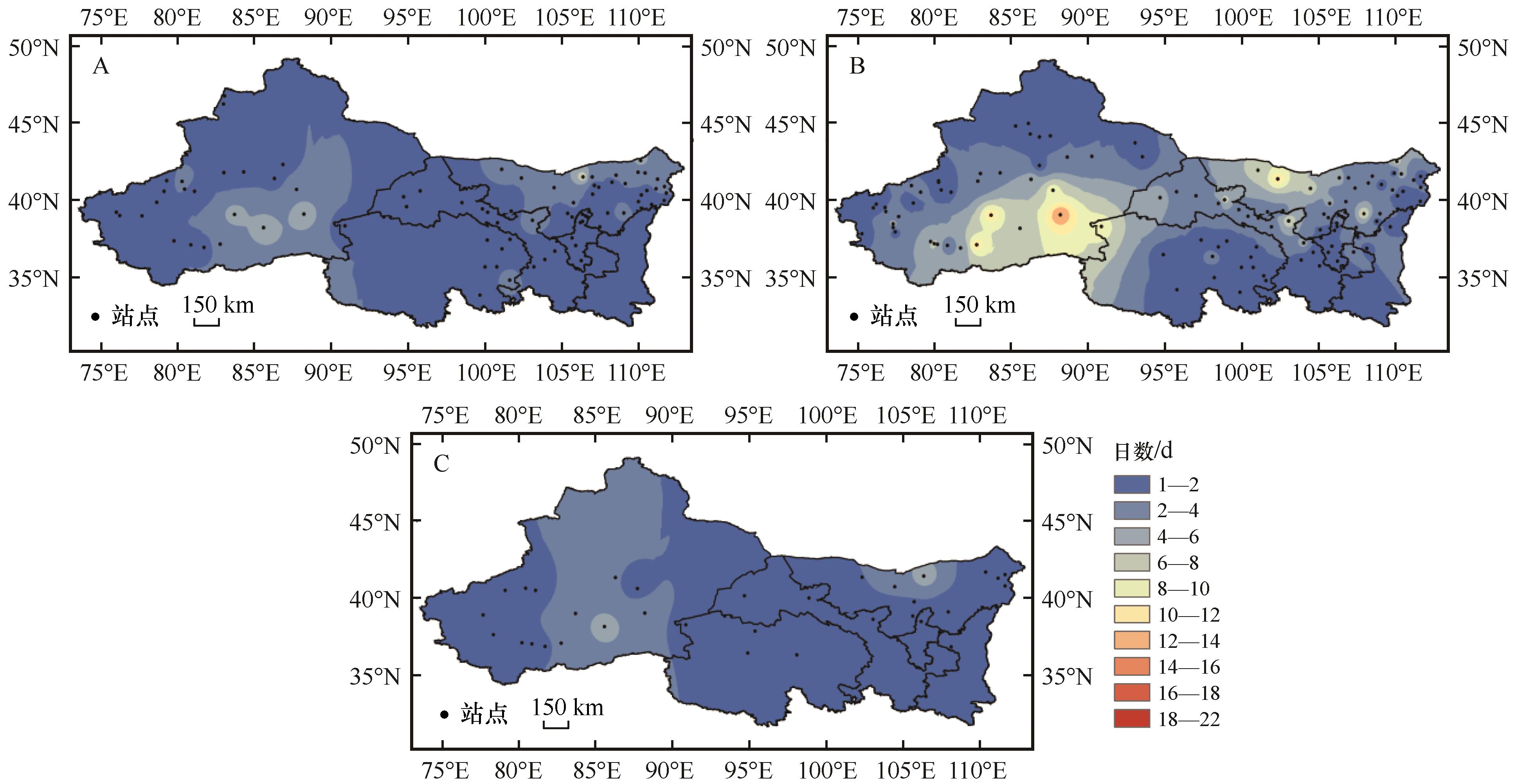
图7 2000—2020年3月(A)、4月(B)、5月(C)西北地区区域性沙尘暴总日数空间分布
Fig.7 Spatial distribution of total annual days of regional sandstorms in March (A), April (B), and May (C) in Northwestern of China from 2000 to 2020
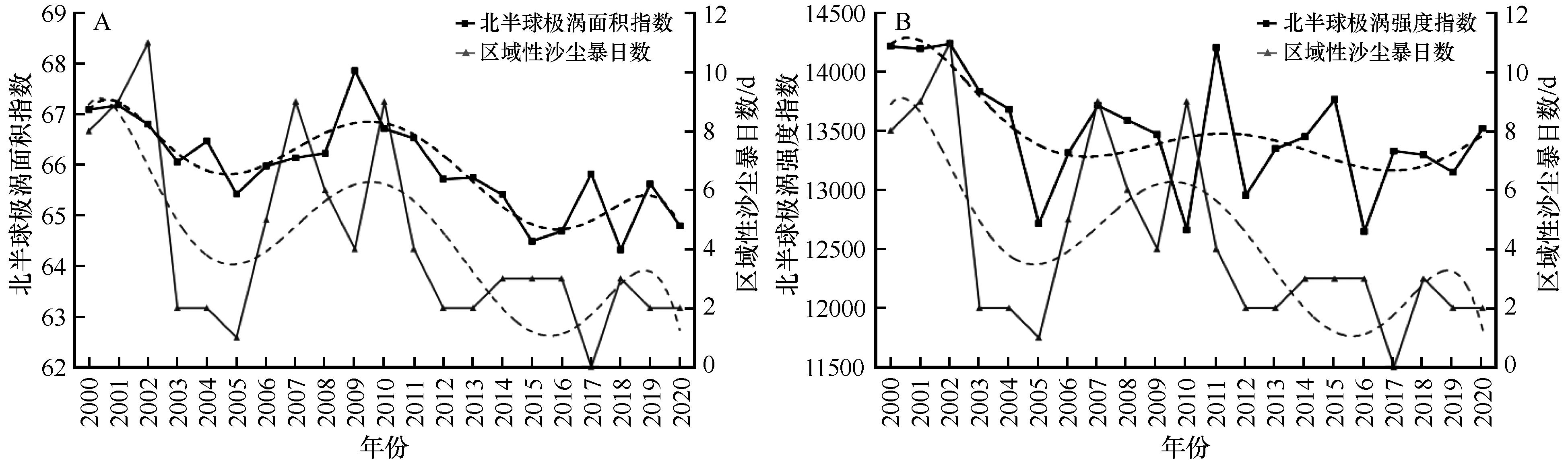
图8 北半球极涡面积(A)、强度(B)指数与区域性沙尘暴日数年变化对比
Fig.8 Comparison of the annual change of Polar vortex area (A), intensity (B) index in the northern hemisphere and the number of days of regional sandstorms
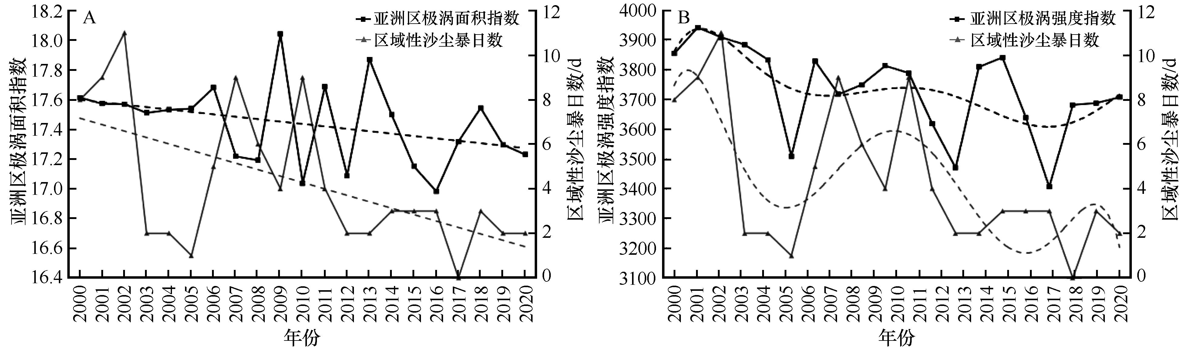
图9 亚洲区极涡面积(A)、强度(B)指数与区域性沙尘暴日数年变化对比
Fig.9 Comparison of the annual change of Polar vortex area (A), intensity (B) index in Asia and the number of days of regional sandstorms
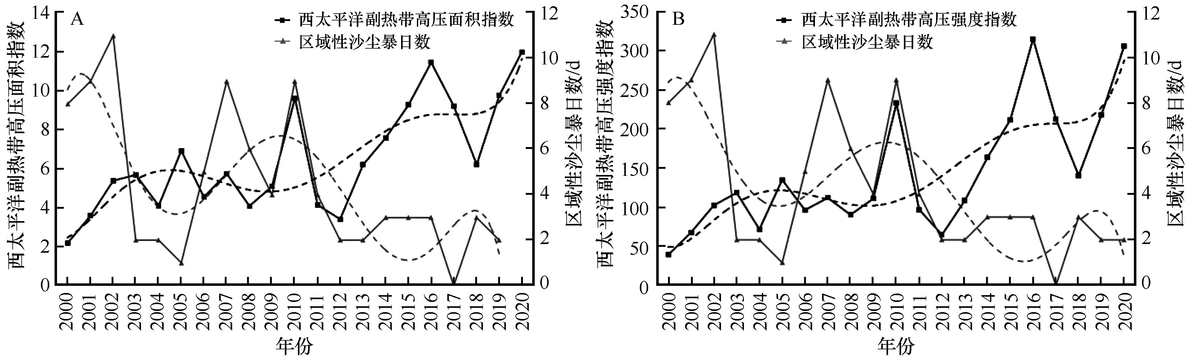
图10 西太平洋副热带高压面积(A)、强度(B)指数与区域性沙尘暴日数年变化对比
Fig.10 Comparison of the annual change of the area (A), intensity (B) index of the western Pacific subtropical high and the number of days of regional sandstorms
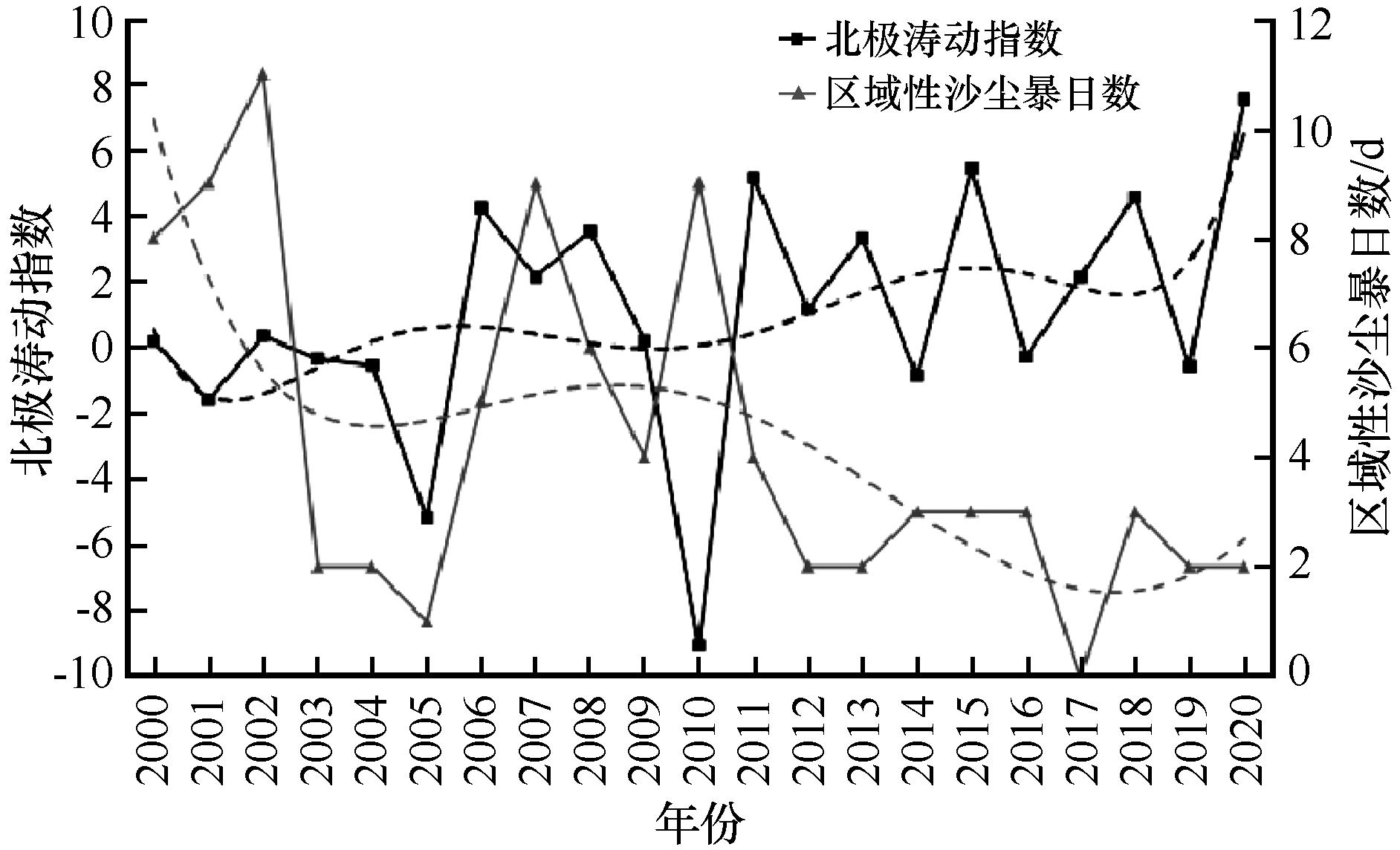
图11 北极涛动指数与区域性沙尘暴日数年变化对比
Fig.11 Comparison of the annual change of the Arctic Oscillation Index and the number of days of regional sandstorms
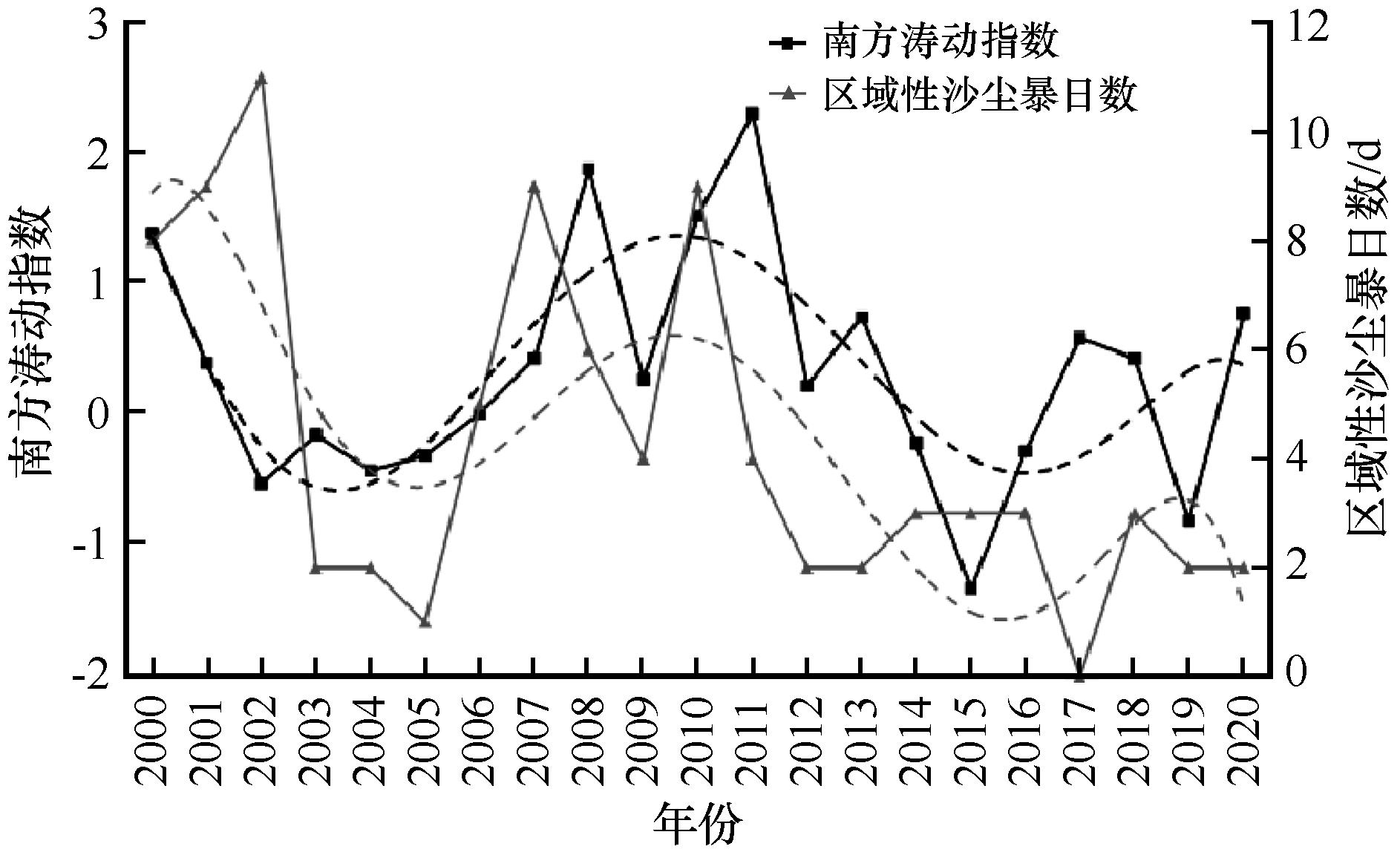
图12 南方涛动指数与区域性沙尘暴日数年变化对比
Fig.12 Comparison of the annual change of the Southern Oscillation Index and the number of days of regional sandstorms
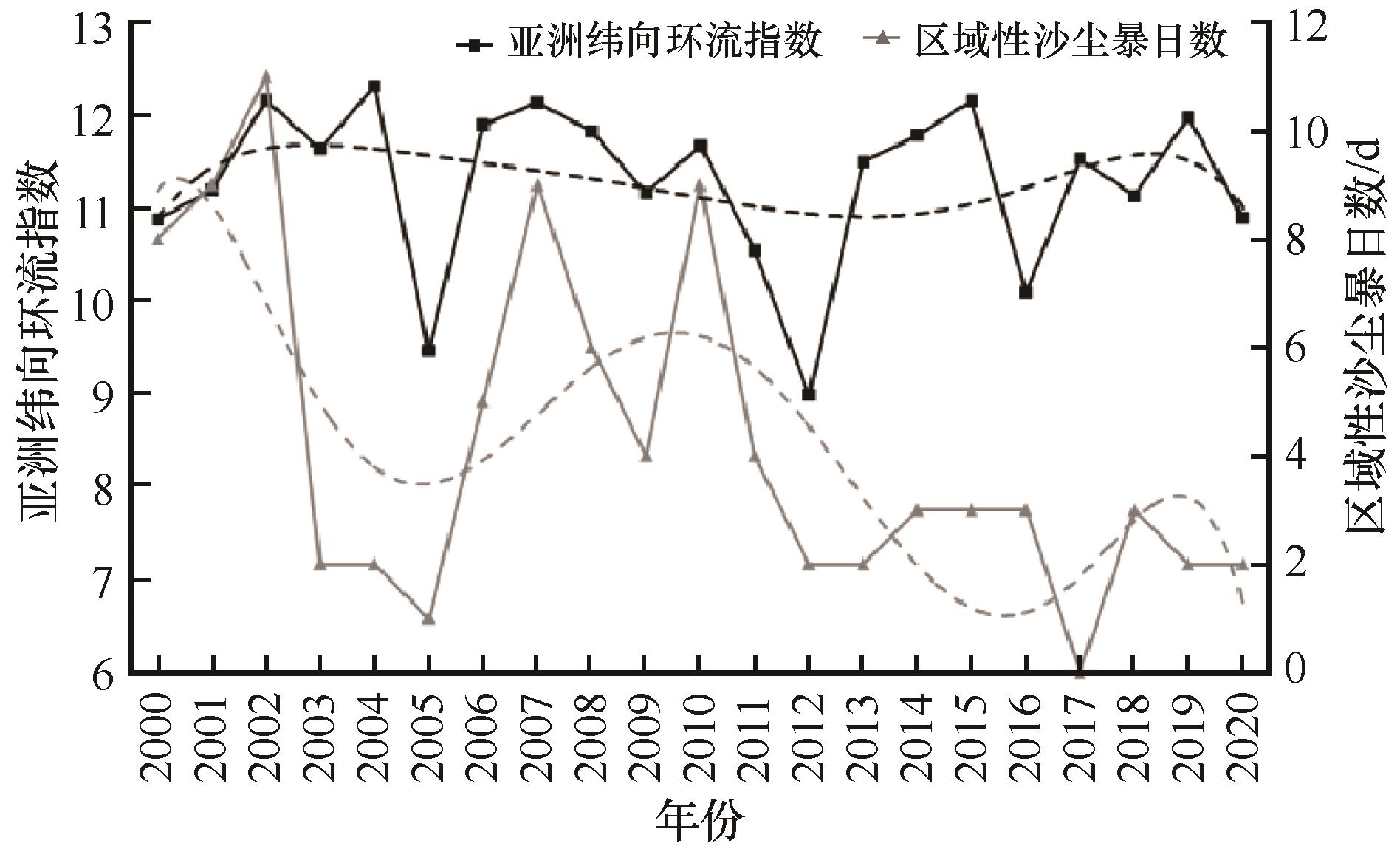
图13 亚洲纬向环流指数与区域性沙尘暴日数年变化对比
Fig.13 Comparison of the annual change of the Asian zonal circulation index and the number of days of regional sandstorms
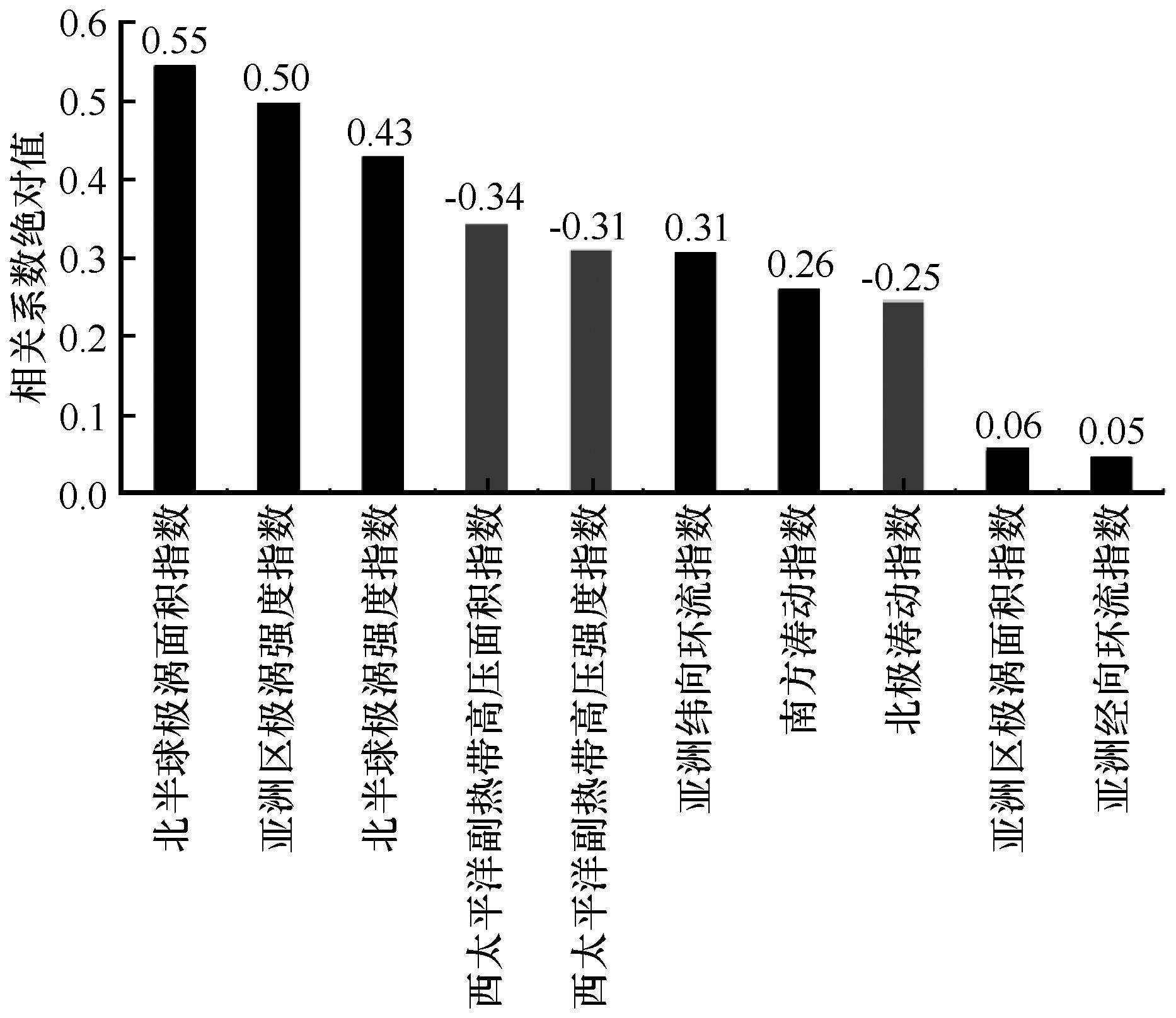
图14 区域性沙尘暴日数与10个气候动力因子相关系数
Fig.14 Correlation coefficients between the number of days of regional sandstorms and 10 climatic dynamic factors
| 气候因子 | 相关系数 | 显著性检验 |
|---|---|---|
| 年平均温度 | 0.002 | |
| 年降水量 | -0.46 | ** |
| 春季平均温度 | -0.29 | |
| 春季降水量 | -0.38 | * |
表1 西北地区年(春季)平均温度、年(春季)降水量与区域性沙尘暴日数相关性检验
Table 1 The correlation test of annual (Spring) average temperature, annual (Spring) precipitation and regional sandstorm days in Northwest of China
| 气候因子 | 相关系数 | 显著性检验 |
|---|---|---|
| 年平均温度 | 0.002 | |
| 年降水量 | -0.46 | ** |
| 春季平均温度 | -0.29 | |
| 春季降水量 | -0.38 | * |
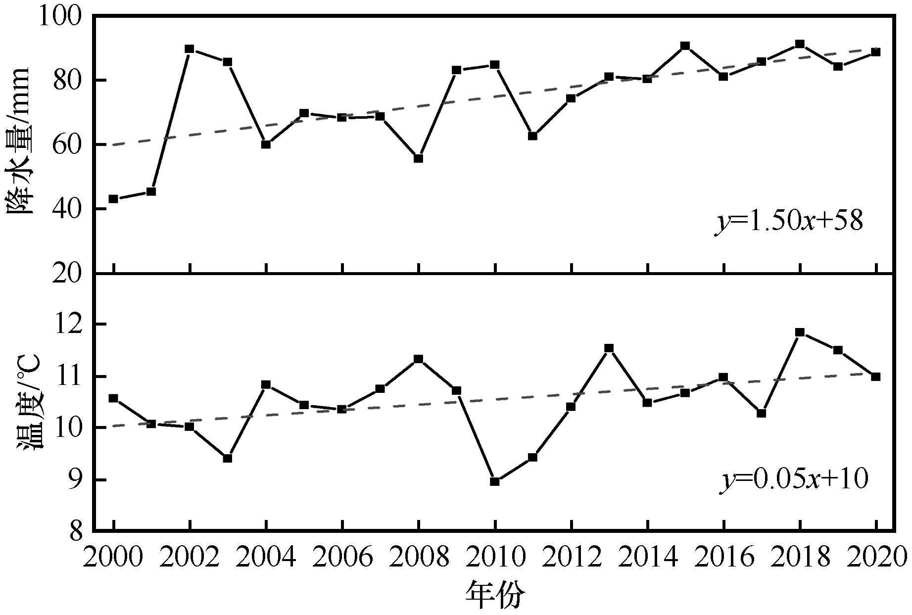
图15 西北地区2000—2020年春季平均温度、春季降水量变化
Fig.15 Changes of spring average temperature and spring precipitation in Northwest of China from 2000 to 2020
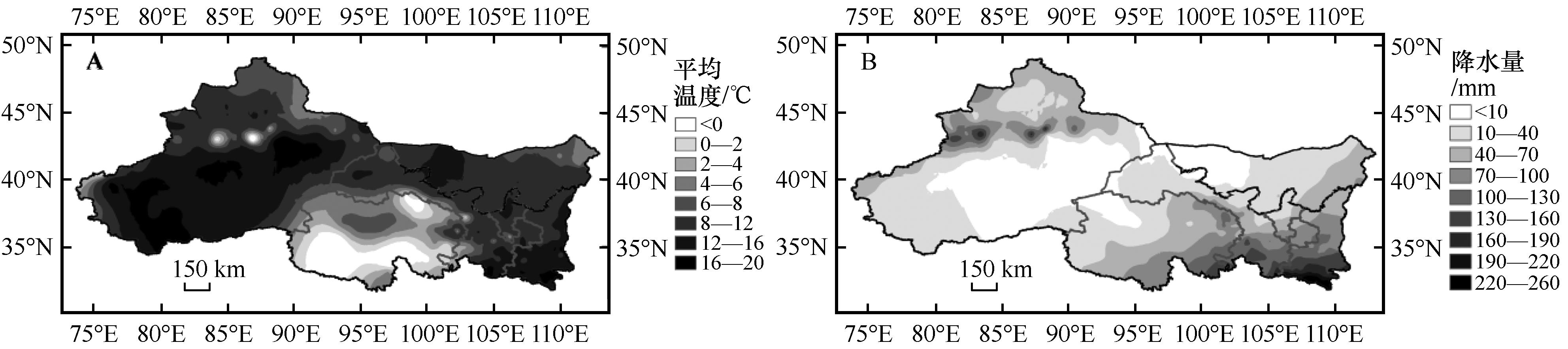
图16 西北地区2000—2020年春季平均温度(A)、春季降水量(B)空间分布
Fig.16 Spatial distribution of spring average temperature (A) and spring precipitation (B) in Northwest of China from 2000 to 2020
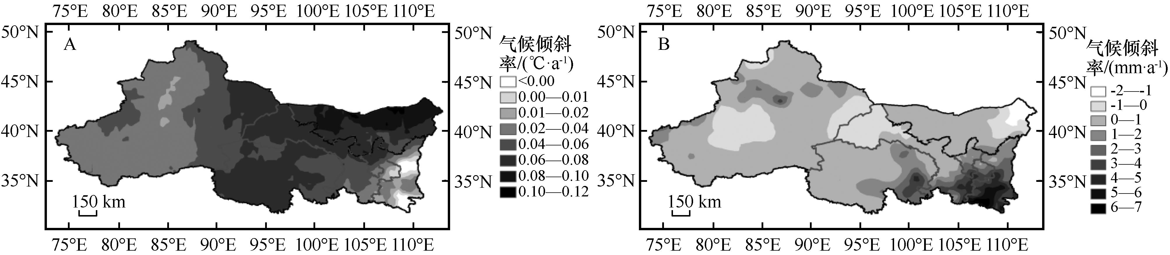
图17 西北地区2000—2020年春季平均温度(A)、春季降水量(B)气候倾斜率空间分布
Fig.17 Spatial distribution of climatic slope of the average spring temperature (A) and spring precipitation (B) in Northwest of China from 2000 to 2020
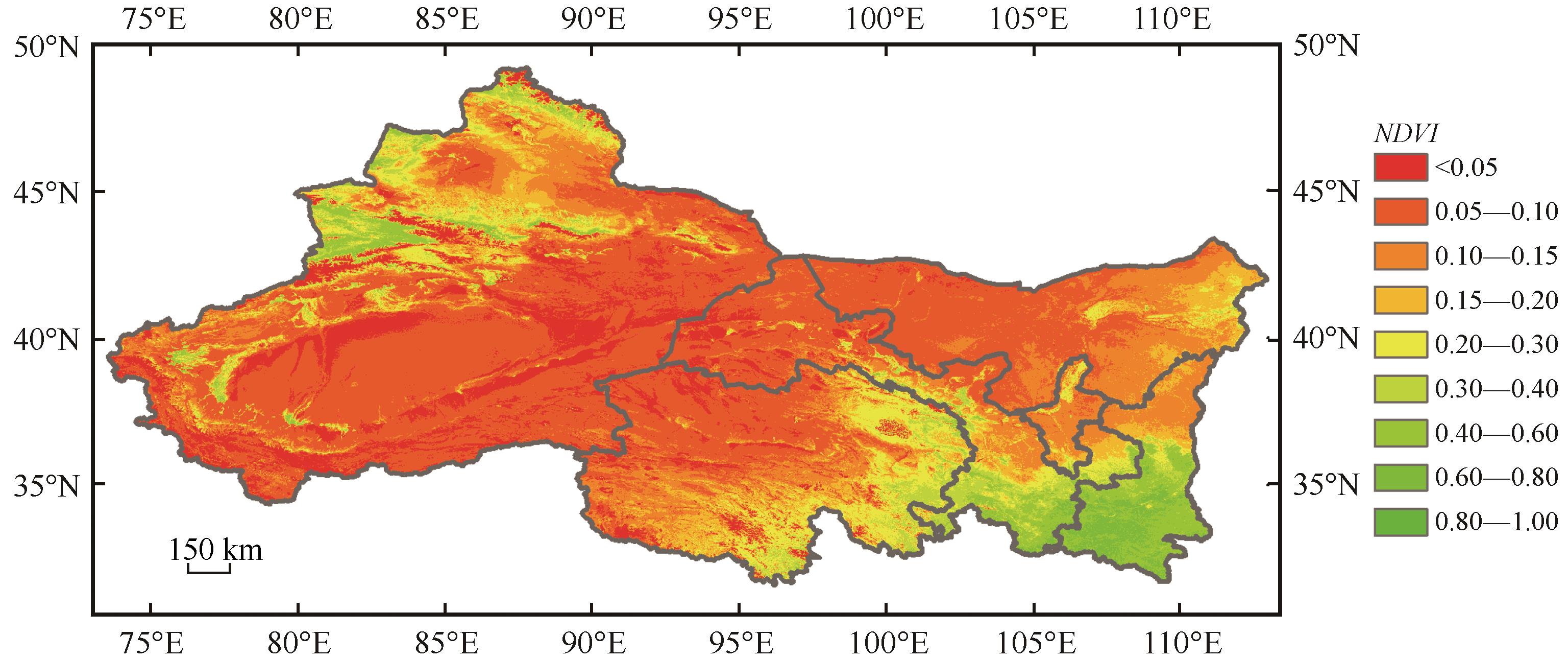
图18 西北地区2000年3—5月平均NDVI空间分布
Fig.18 Spatial distribution of average NDVI from March to May in Northwest of China in 2000
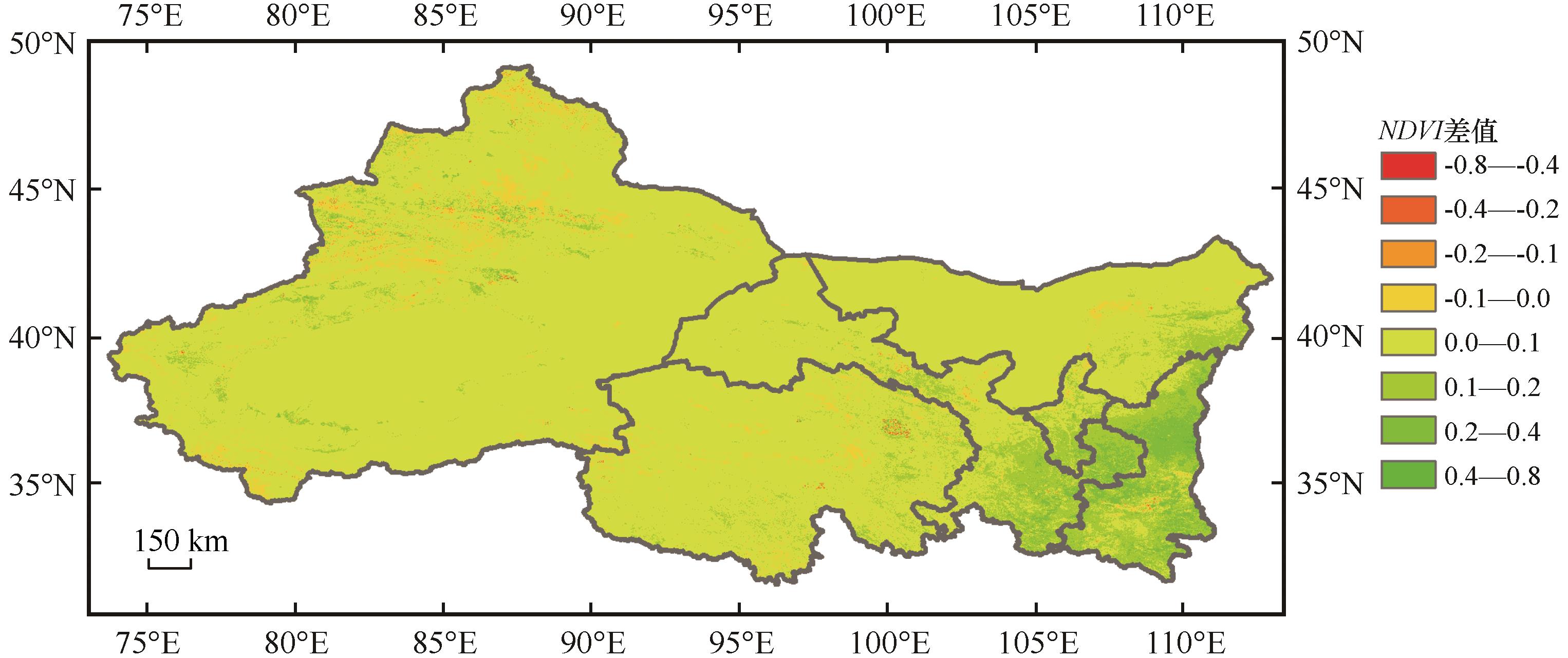
图19 西北地区2020年与2000年3—5月平均NDVI差值分布
Fig.19 Distribution of the difference between 2020 and 2000 of average NDVI from March to May in Northwest of China
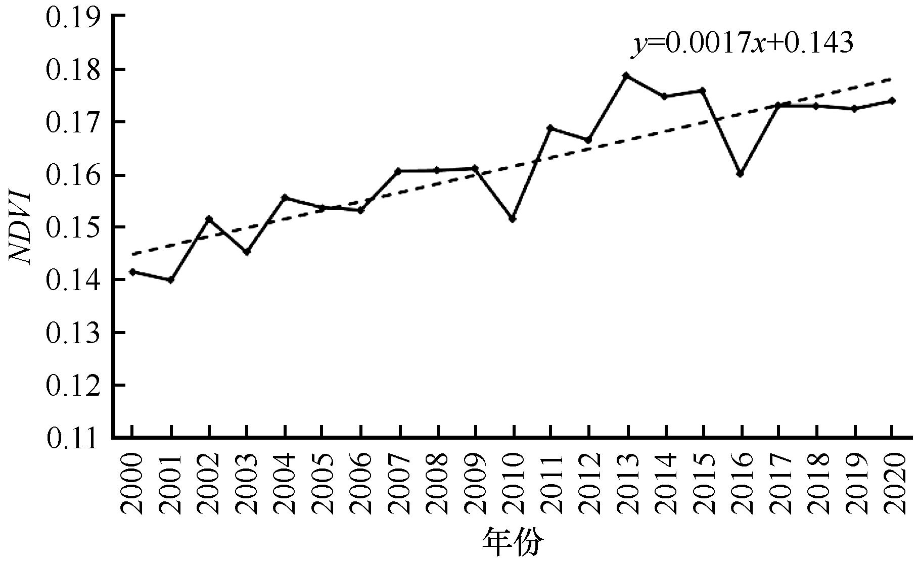
图20 西北地区2000—2020年NDVI逐年变化
Fig.20 Changes of annual NDVI in Northwest of China from 2000 to 2020
| 1 | 钱正安,宋敏红,李万元.近50年来中国北方沙尘暴的分布及变化趋势分析[J].中国沙漠,2002,22(2):107-111. |
| 2 | 杨晓军,张强,叶培龙,等.中国北方2021年3月中旬持续性沙尘天气的特征及其成因[J].中国沙漠,2021,41(3):245-255. |
| 3 | 周自江,章国材.中国北方典型强沙尘暴事件(1954-2002年)[J].科学通报,2003,48(11):1224-1228. |
| 4 | 张瑞军,何清,孔丹,等.近几年国内沙尘暴研究的初步评述[J].干旱气象,2007,23(3):88-94. |
| 5 | 陶健红.西北地区沙尘天气的气候特征及其影响研究[D].南京:南京信息工程大学,2007. |
| 6 | 张芝娟,衣育红,陈斌,等.2018年春季中国北方大范围沙尘天气对城市空气质量的影响及其天气学分析[J].中国沙漠,2019,39(6):13-22. |
| 7 | 姜大海,王式功,尚可政.沙尘暴危险度的定量评估研究[J].中国沙漠,2011,31(6):207-215. |
| 8 | 李岩瑛,杨晓玲,王式功.河西走廊东部近50 a沙尘暴成因、危害及防御对策[J].中国沙漠, 2002,22(3):283-287. |
| 9 | 陈锦,李东庆,喻光明,等.近40年来西北地区沙尘暴日数时空分布及变化趋势[J].华中师范大学学报(自然科学版),2008(4):659-664. |
| 10 | 冯建英,陈旭辉,陆登荣,等.我国西北干旱区区域性沙尘暴特征及成因研究[J].中国沙漠,2004,24(5):582-587. |
| 11 | 陈晓光,张存杰,董安祥,等.甘肃省沙尘暴过程的划分及统计分析[J].高原气象,2004,23(3):374-381. |
| 12 | 王式功,王金艳,周自江,等.中国沙尘天气的区域特征[J].地理学报,2003,58(2):193-200. |
| 13 | 杨晓玲,丁文魁,钱莉,等.一次区域性大风沙尘暴天气成因分析[J].中国沙漠,2005,25(5):702-705. |
| 14 | 李玲萍,李岩瑛,李晓京,等.河西走廊不同强度冷锋型沙尘暴环流和动力特征[J].中国沙漠,2021,41(5):219-228. |
| 15 | 张彩霞,王训明,郭坚.西北地区植被变化对风沙活动的影响分析[J].中国沙漠,2010,30(2):254-259. |
| 16 | 李丹华,隆霄,温晓培,等.河西走廊入口区下垫面对沙尘天气影响的模拟研究[J].中国沙漠,2017,37(6):1210-1218. |
| 17 | 沈洁,李耀辉,朱晓炜.西北地区气候与环境变化影响沙尘暴的研究进展[J].干旱气象,2010,28(4):467-474. |
| 18 | 施雅风,沈永平,胡汝骥.西北气候由暖干向暖湿转型的信号、影响和前景初步探讨[J].冰川冻土,2002(3):219-226. |
| 19 | 杨蓉,赵多平.气候变暖背景下陕甘宁蒙接壤区1961-2015年降水变化响应特征[J].水土保持通报,2018,38(3):269-274. |
| 20 | 张强,张存杰,白虎志,等.西北地区气候变化新动态及对干旱环境的影响:总体暖干化局部出现暖湿迹象[J].干旱气象,2010,28(1):1-7. |
| 21 | 张钛仁,张佳华,申彦波,等.1981-2001年西北地区植被变化特征分析[J].中国农业气象,2010,31(4):586-590. |
| 22 | 郭铌,王小平,蔡迪花,等.近20多年来西北绿洲植被指数的变化及其成因[J].干旱区研究,2010,27(1):75-82. |
| 23 | 邓朝平,郭铌,王介民,等.近20余年来西北地区植被变化特征分析[J].冰川冻土,2006(5):686-693. |
| 24 | 周秀骥,徐祥德,颜鹏,等.2000年春季沙尘暴动力学特征[J].中国科学D辑,2002, 32(4):327-327. |
| 25 | 冯永忠,刘强,李永平,等.近55年来中国西北地区沙尘暴发生时空特征分析[J].西北农林科技大学学报(自然科学版),2010(5):196-200. |
| 26 | 杜宏印,郭浩,崔向慧,等.中国主要沙尘暴源区稳定同位素背景值初步研究[J].中国沙漠,2016,36(3):604-609. |
| 27 | 常茜,鹿化煜,吕娜娜,等.1992-2015年中国沙漠面积变化的遥感监测与气候影响分析[J].中国沙漠,2020,40(1):57-63. |
| 28 | 中国气象局.地面气象观测规范[M].北京:气象出版社,2003:19-34. |
| 29 | 毛耀顺.沙尘天气预警业务服务暂行规定[Z]//中国气象年鉴,2003. |
| 30 | 达布希拉图,赵春生.气候因子对内蒙古沙尘暴频率的影响[J].大气科学,2004,28(6):828-834. |
| 31 | 郭晓宁,杨延华,马元仓,等.柴达木盆地春季沙尘暴变化特征分析[J].干旱区资源与环境,2018,32(8):107-113. |
| 32 | Thompson D W J, Wallace J M.Structure of the Arctic and Antarctic collation[C]//Proceeding of the Twenty Third Annual Climate Diagnostics and Prediction Work Shop.NOAA,NWS,CPC/ NCEP,1999:281-284. |
| 33 | Thompson D W J, Wallace J M.Regional climate in pacts of the northern hemisphere annular mode and associated climate trends[J].Science,2001,293(5527):85-89. |
| 34 | 郑广芬,赵光平,姚宗国,等.北极涛动异常对西北地区东部沙尘暴频次的影响[J].中国沙漠,2009,29(3):551-557. |
| 35 | 陈大可,连涛.厄尔尼诺-南方涛动研究新进展[J].科学通报,2020,65(35):4001-4003. |
| 36 | 陈巧,陈永富,胡庭兴.地表土壤湿度和植被状况的监测及其与沙尘暴发生的关系探讨[J].四川农业大学学报,2005,23(3):295-299. |
| 37 | 王雁鹏,陈岩,殷惠民,等.中国北方沙尘传输的数值模拟[J].干旱气象,2007,23(3):1-9. |
| 38 | 特日格乐.蒙古国沙尘暴对内蒙古沙尘暴的影响研究[D].呼和浩特:内蒙古师范大学,2016. |
| 39 | 段伯隆,刘新伟,郭润霞,等.“3·15”北方强沙尘暴天气成因分析[J].干旱气象,2021,39(4):541-553. |
| 40 | 柳本立,彭婉月,刘树林,等.2021年3月中旬东亚中部沙尘天气地面起尘量及源区贡献率估算[J].中国沙漠,2022,42(1):79-86. |
| 41 | 陈芳,刘虎俊,刘淑娟,等.基于MODIS的蒙古国2003-2017年荒漠化动态监测[J].西北林学院学报,2019,34(5):167-171. |
| 42 | 王蕊,李虎.2001-2010年蒙古国MODIS-NDVI时空变化监测分析[J].地球信息科学学报,2011,13(5):665-671. |
| [1] | 柳欣滢, 金明, 杨帆, 马亚鹏, 刘慧, 孙小云, 夏敦胜. 毛乌素沙地东缘中全新世以来环境变化及其对文明演化的影响初探[J]. 中国沙漠, 2022, 42(5): 92-100. |
| [2] | 尹振良, 冯起, 王凌阁, 陈泽霞, 常亚斌, 朱睿. 2000—2019年中国西北地区植被覆盖变化及其影响因子[J]. 中国沙漠, 2022, 42(4): 11-21. |
| [3] | 朱士华, 方霞, 杭鑫, 谢小萍, 孙良宵, 曹良中. 中亚草地植被指数( NDVI )对气候变化及人类活动的响应[J]. 中国沙漠, 2022, 42(4): 229-241. |
| [4] | 陈雪萍, 赵学勇, 王瑞雄, 宁志英, 卢建男, 赵思腾. 气候变化与土地利用/覆被变化对中国北方农牧交错带水资源影响研究进展[J]. 中国沙漠, 2022, 42(3): 170-177. |
| [5] | 宫毓来, 马绍休, 刘伟琦. 机器学习与统计模型在石羊河流域气候降尺度研究中的适用性对比[J]. 中国沙漠, 2022, 42(1): 196-210. |
| [6] | 柳本立, 彭婉月, 刘树林, 杨婷. 2021年3月中旬东亚中部沙尘天气地面起尘量及源区贡献率估算[J]. 中国沙漠, 2022, 42(1): 79-86. |
| [7] | 雷燕慧, 丁国栋, 李梓萌, 迟文峰, 高广磊, 赵媛媛. 京津风沙源治理工程区土地利用/覆盖变化及生态系统服务价值响应[J]. 中国沙漠, 2021, 41(6): 29-40. |
| [8] | 马晓慧, 庞奖励, 刘小槺, 丁丹, 岳晓晓, 贾飞飞. 瓦窑沟剖面记录的早中全新世毛乌素沙地东南缘气候变化[J]. 中国沙漠, 2021, 41(5): 71-80. |
| [9] | 张小梅, 靳鹤龄, 刘冰. 末次盛冰期以来库布齐沙漠环境变化[J]. 中国沙漠, 2021, 41(5): 81-93. |
| [10] | 马永桃, 任孝宗, 胡慧芳, 刘敏, 孟琪. 基于地理探测器的浑善达克沙地植被变化定量归因[J]. 中国沙漠, 2021, 41(4): 195-204. |
| [11] | 韩兰英, 张强, 马鹏里, 王有恒, 黄涛, 贾建英, 王鑫, 王小巍, 刘卫平, 李丹华, 卢国阳, 黄鹏程, 白冰. 气候变暖背景下黄河流域干旱灾害风险空间特征[J]. 中国沙漠, 2021, 41(4): 225-234. |
| [12] | 王有恒, 谭丹, 韩兰英, 李丹华, 王鑫, 卢国阳, 林婧婧. 黄河流域气候变化研究综述[J]. 中国沙漠, 2021, 41(4): 235-246. |
| [13] | 贺晓慧, 司建华, 赵春彦, 王春林, 周冬蒙. 西藏沙棘(Hippophae thibetana)潜在地理分布及其对未来气候变化的响应模拟[J]. 中国沙漠, 2021, 41(3): 101-109. |
| [14] | 贾瑞, 李君, 祝清哲, 李妍, 田云菲, 李阳, 徐征豹. 中国西北地区气溶胶的三维分布特征及其成因[J]. 中国沙漠, 2021, 41(3): 34-43. |
| [15] | 何远政, 黄文达, 赵昕, 吕朋, 王怀海. 气候变化对植物多样性的影响研究综述[J]. 中国沙漠, 2021, 41(1): 59-66. |
| 阅读次数 | ||||||
|
全文 |
|
|||||
|
摘要 |
|
|||||
©2018中国沙漠 编辑部
地址: 兰州市天水中路8号 (730000)
电话:0931-8267545
Email:caiedit@lzb.ac.cn;desert@lzb.ac.cn

 甘公网安备 62010202000688号