| 1 |
刘彦随,吴传钧.中国水土资源态势与可持续食物安全[J].自然资源学报,2002,17(3):270-275.
|
| 2 |
杨宏轶,赵华甫.耕地结构变化下水土资源匹配时空特征效应分析:以黑龙江省为例[J].自然资源学报,2022,37(9):2247-2263.
|
| 3 |
Cheng K, Fu Q, Chen X,et al.Adaptive allocation modeling for a complex system of regional water and land resources based on information entropy and its application[J].Water Resources Management,2015,29(14):4977-4993.
|
| 4 |
黄飞.粮代处出席《2021年世界粮食和农业领域土地及水资源状况》高级别发布会[J].世界农业,2022(1):133.
|
| 5 |
李志赟,邓晓雅,龙爱华,等.三维生态足迹视角下塔里木河流域水土资源与生态承载状况评价[J].环境工程,2022,40(6):286-294.
|
| 6 |
段春青,刘昌明,陈晓楠,等.区域水资源承载力概念及研究方法的探讨[J].地理学报,2010,65(1):82-90.
|
| 7 |
赵自阳,李王成,张宇正,等.基于DPSIR模型的宁夏农业水土资源安全评价[J].浙江农业学报,2017,29(8):1336-1346.
|
| 8 |
李慧,周维博,庄妍,等.延安市农业水土资源匹配及承载力[J].农业工程学报,2016,32(5):156-162.
|
| 9 |
马利邦,田亚亚,郭晓东,等.基于格网的河西绿洲乡村聚落时空演变及其与水土资源的空间耦合关系[J].自然资源学报,2018,33(5):775-787.
|
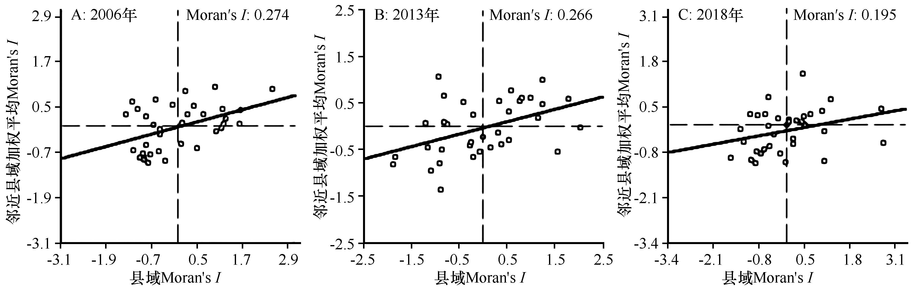
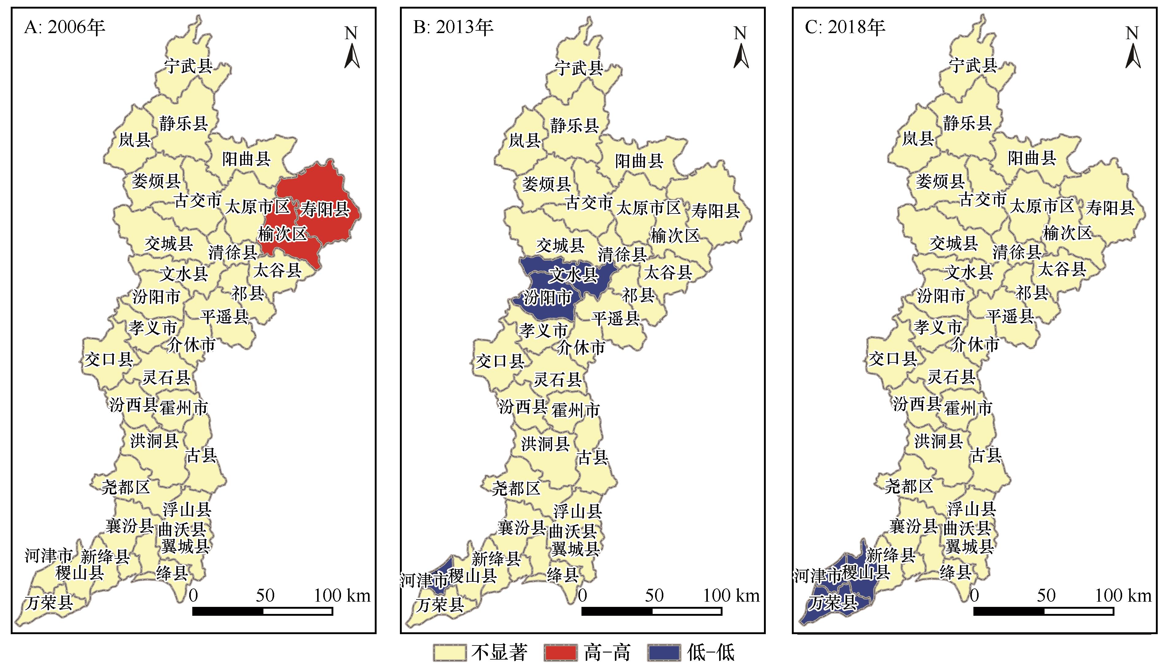
| 10 |
刘彦随,甘红,张富刚.中国东北地区农业水土资源匹配格局[J].地理学报,2006,61(8):847-854.
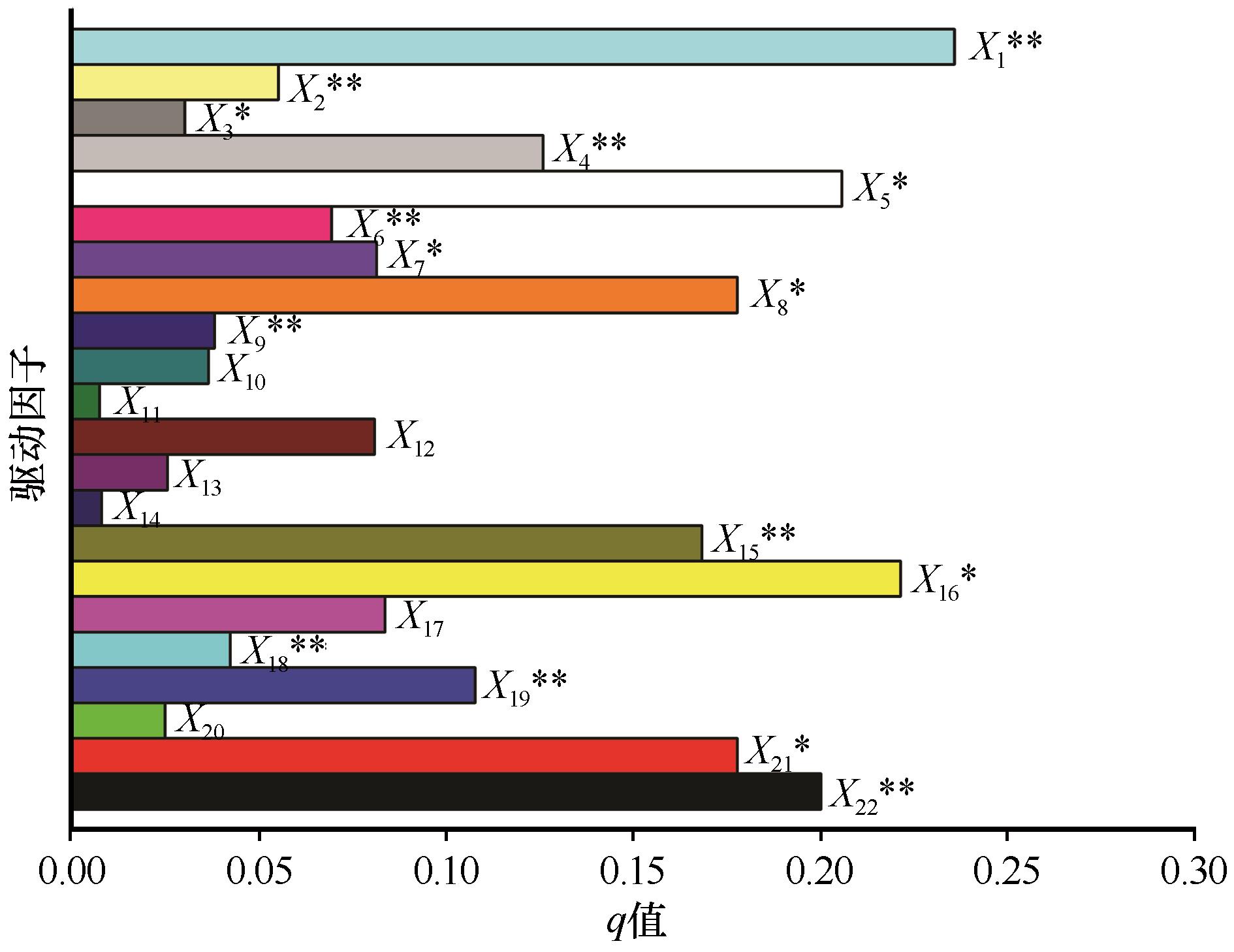
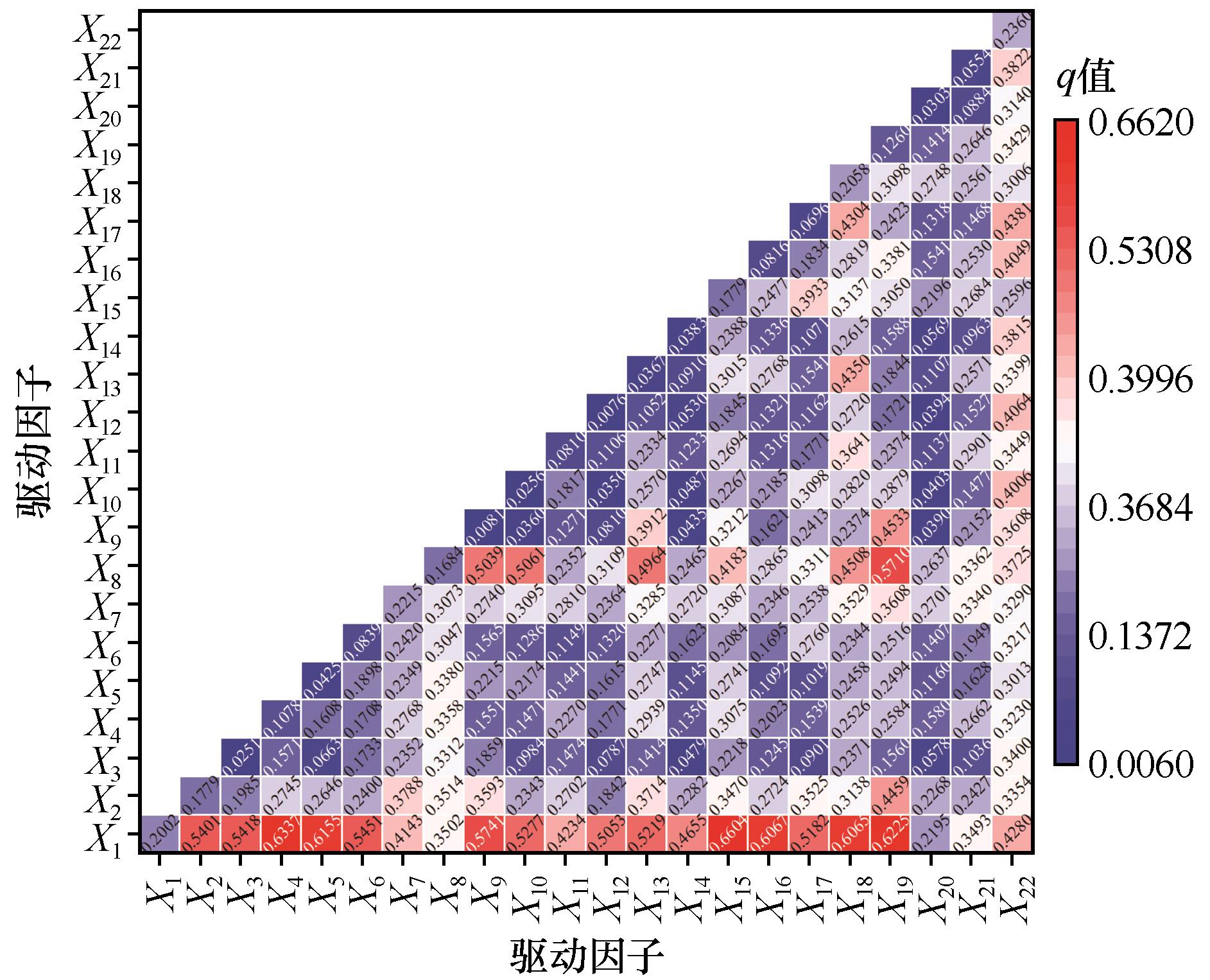
|
| 11 |
张立杰,李健.西江流域环境资源公平性评价[J].中国沙漠,2018,38(3):673-680.
|
| 12 |
李光勤,方徐兵.黄河流域绿色发展水平时空演变特征[J].中国沙漠,2021,41(4):129-139.
|
| 13 |
谭琨,赵祖军,赵筱青,等.喀斯特山区文山市水土资源利用变化特征及耦合研究[J].水土保持研究,2021,28(4):324-332.
|
| 14 |
王凌阁,朱睿,陈泽霞,等.甘肃河西地区2000-2019年水土资源耦合协调特征[J].中国沙漠,2022,42(2):44-53.
|
| 15 |
Lu W N, Liu W X, Hong M Y,et al.Spatial-temporal evolution characteristics and influencing factors of agricultural water use efficiency in northwest China:based on a super-DEA Model and a spatial panel econometric model[J].Water,2021,13(5):632.
|
| 16 |
钞锦龙,李乐乐,杨朔,等.汾河流域城市化与水资源耦合协调关系研究[J].地理科学,2022,42(3):487-496.
|
| 17 |
段丽军,于金贵,曹金亮,等.汾河流域矿山生态环境问题现状及治理修复对策[J].西部探矿工程,2022,34(2):169-170.
|
| 18 |
申豪勇,李佳,王志恒,等.黄河支流汾河流域水资源开发利用现状及生态环境问题[J].中国地质,2022,49(4):1127-1138.
|
| 19 |
谭琨.喀斯特山区文山市水土资源耦合及调控研究[D].昆明:云南大学,2020.
|
| 20 |
胡航箫,戴文远,徐乙文,等.福州山区乡村聚落空间格局及其与水土资源的耦合态势[J].生态与农村环境学报,2021,37(2):164-171.
|
| 21 |
文倩,孟天醒,范慧平,等.河南省水土资源与经济发展耦合效应及其时空分异[J].水土保持研究,2017,24(3):234-240.
|
| 22 |
魏小芳,赵宇鸾,李秀彬,等.基于“三生功能”的长江上游城市群国土空间特征及其优化[J].长江流域资源与环境,2019,28(5):1070-1079.
|
| 23 |
璩路路,王永生,刘彦随,等.乡村振兴导向的水土资源承载力评价及其优化[J].自然资源学报,2021,36(2):300-314.
|
| 24 |
杨浩,吴才武,周思言,等.京津冀地区城镇化与资源环境协调发展研究[J].干旱区资源与环境,2020,34(9):17-24.
|
| 25 |
王淑佳,孔伟,任亮,等.国内耦合协调度模型的误区及修正[J].自然资源学报,2021,36(3):793-810.
|
| 26 |
李强,苏迎庆,冯珍珍,等.汾河流域三生空间功能耦合协调研究[J].中国水土保持科学(中英文),2021,19(5):115-125.
|
| 27 |
林晋大,多玲花,邹自力.城市扩张背景下景观破碎化动态演变及空间自相关分析:以南昌市为例[J].水土保持研究,2022,29(4):362-369.
|
| 28 |
许锋.基于Moran指数和谱图论的空间自相关测度方法优化[J].城市发展研究,2021,28(12):92-101.
|
| 29 |
王劲峰,徐成东.地理探测器:原理与展望[J].地理学报,2017,72(1):116-134.
|
| 30 |
王劲峰,葛咏,李连发,等.地理学时空数据分析方法[J].地理学报,2014,69(9):1326-1345.
|
| 31 |
苏迎庆,刘庚,赵景波,等.2006-2018年汾河流域土地生态安全预警测度及时空格局演变[J].水土保持通报,2021,41(1):144-151.
|
| 32 |
刘海龙,王炜桥,王跃飞,等.汾河流域生态敏感性综合评价及时空演变特征[J].生态学报,2021,41(10):3952-3964.
|
 ), 苏迎庆2,3, 张云枫1, 李育桢1, 李可璇1, 刘庚1(
 甘公网安备 62010202000688号