img

官方微信

高级检索

中国沙漠 ›› 2025, Vol. 45 ›› Issue (5): 172-180.DOI: 10.7522/j.issn.1000-694X.2025.00184

• • 上一篇    

典型黄土高原沟壑区土地利用与景观格局变化分析——以甘肃省庆阳市为例

李彩霞(), 武雪, 胡杨   

  1. 甘肃省地矿局第三地质矿产勘查院,甘肃 兰州 730050
  • 收稿日期:2025-05-15 修回日期:2025-06-30 出版日期:2025-09-20 发布日期:2025-09-27
  • 作者简介:李彩霞(1984—),女,甘肃兰州人,工程师,主要从事水文地质、环境地质工作。E-mail: 13919305461@163.com
  • 基金资助:
    甘肃省青年科技基金项目(23JRRA671)

Land use and landscape pattern changes in QingyangGansuChinaa typical Loess Plateau gully region

Caixia Li(), Xue Wu, Yang Hu   

  1. Institute of Geology and Mineral Exploration,Gansu Provincial Bureau of Geology and Mineral Resources,Lanzhou 730050,China
  • Received:2025-05-15 Revised:2025-06-30 Online:2025-09-20 Published:2025-09-27

摘要:

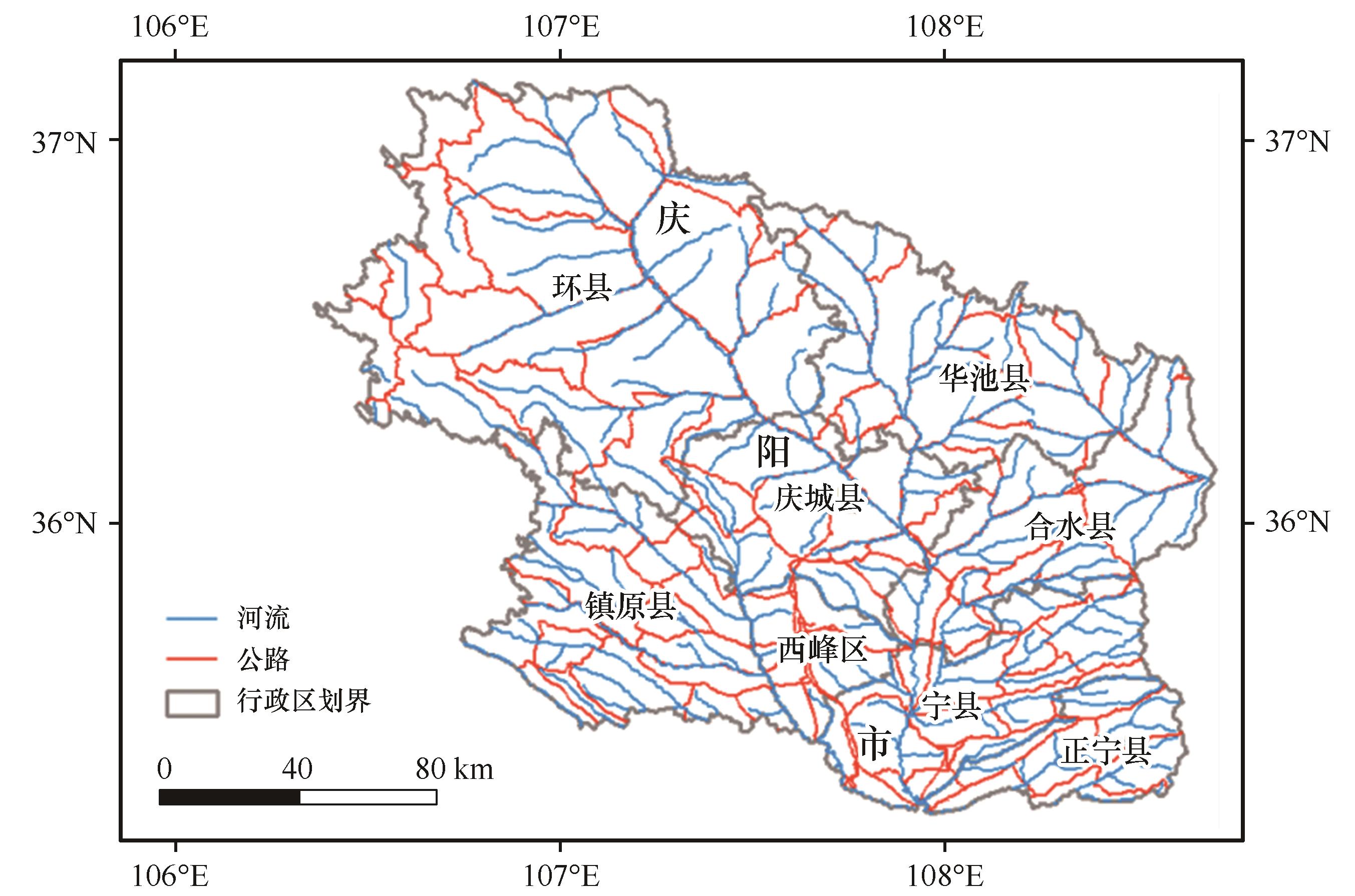
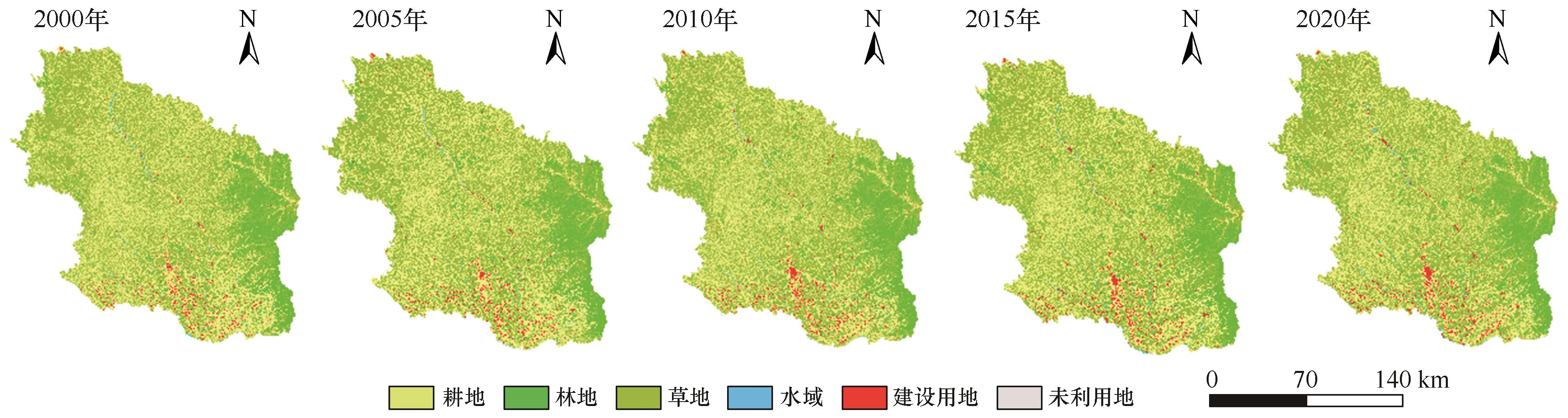
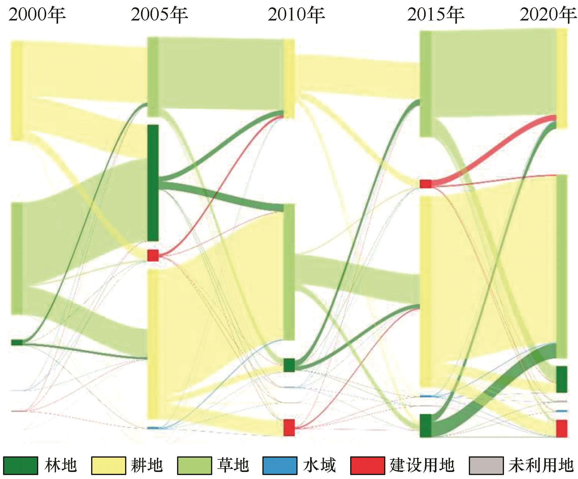
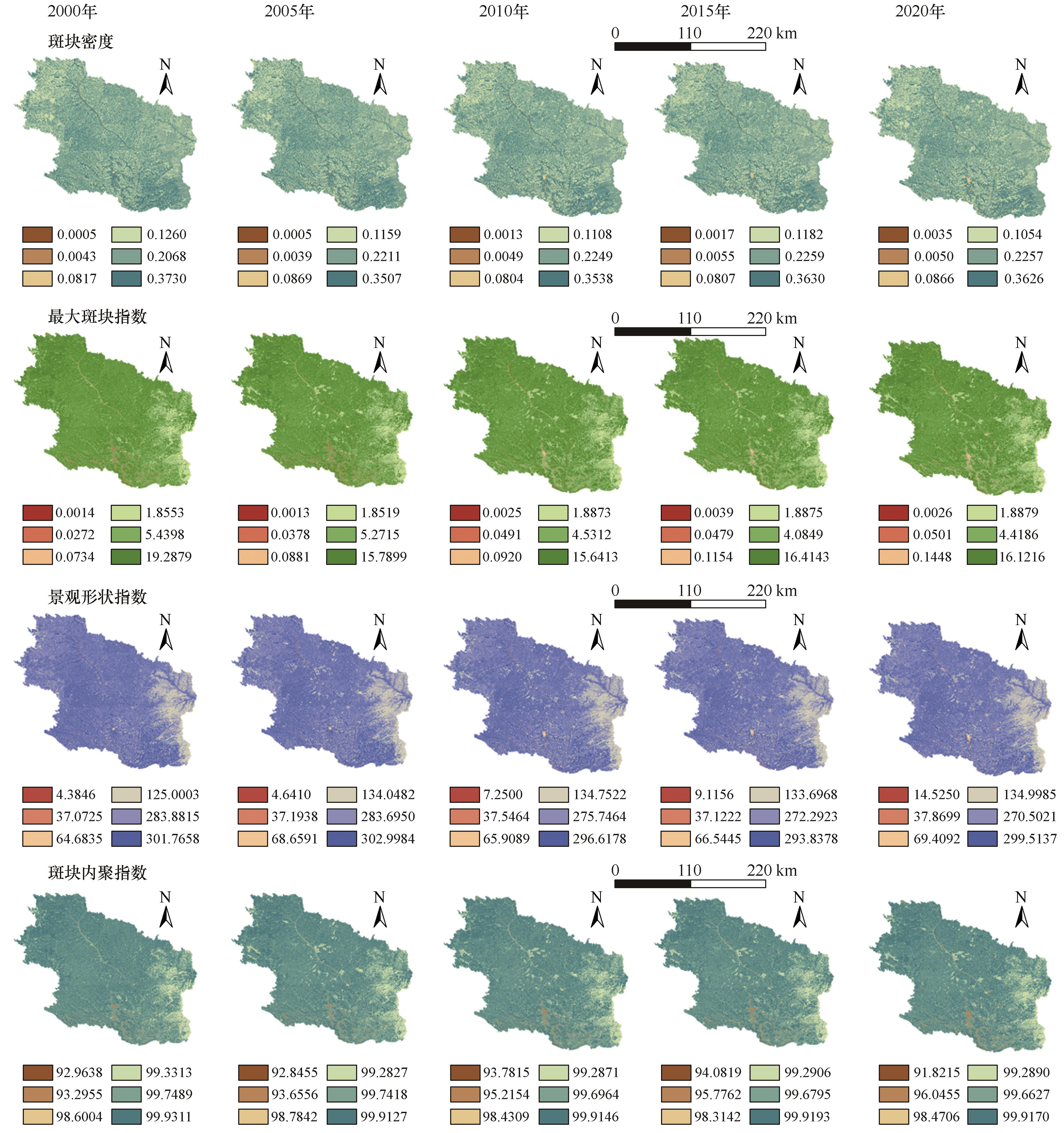
黄土高原沟壑区景观格局变化反映了黄土高原区域生态功能与过程的变化,其空间分异揭示了景观过程及其驱动力的空间差异,有助于从空间上把握区域景观格局动态变化过程与特征。本文以甘肃省庆阳市为例,基于2000—2020年土地利用数据,运用ArcGIS和Fragstats软件,系统分析了区域土地利用变化与景观格局的时空动态特征及生态响应,揭示典型黄土高原沟壑区土地利用与景观格局变化的空间分异特征。结果表明:(1) 2000—2020年研究区土地利用结构发生显著转变,呈现耕地持续减少、林地和草地先增后稳、建设用地扩张的总体趋势,减少耕地的转移方向主要为草地、林地和建设用地;(2)景观格局指数随时间并无明显的变化趋势,但研究区景观空间分异特征明显,具体表现为西北部斑块具有相对较高的生态优势、中部区域斑块面积分布破碎化程度更高、东南边缘区域景观类型相对单一且斑块形状规则;(3)耕地和草地面积变化与景观格局指数存在相关性,地区生产总值和人口总数是景观指数变化的主要驱动因素,这意味着随时间推移研究区生态空间与社会经济空间融合程度在不断加深。

关键词: 土地利用变化, 景观格局, 时空动态, 庆阳

Abstract:

The changes in landscape patterns in the Loess Plateau gully region reflect the variations in regional ecological functions and processes. Their spatial differentiation reveals the spatial disparities in landscape processes and their driving forces, aiding in the spatial understanding of the dynamic changes and characteristics of regional landscape patterns. Taking Qingyang City, Gansu Province, as an example, this study systematically analyzed the spatiotemporal dynamics of regional land use changes and landscape patterns, as well as their ecological responses, based on land use data from 2000 to 2020, using ArcGIS and Fragstats software. The aim was to uncover the spatial differentiation characteristics of land use and landscape pattern changes in a typical Loess Plateau gully region. The results indicate: (1) From 2000 to 2020, the land use structure in the study area underwent significant transformations, showing an overall trend of "continuous decrease in cropland, initial increase followed by stabilization in forest and grassland, and expansion of construction land." The primary transitions of reduced cropland were to grassland, forest, and construction land. (2) The landscape pattern indices did not exhibit a clear temporal trend, but the study area displayed distinct spatial differentiation in landscape patterns. Specifically, patches in the northwestern region showed relatively higher ecological dominance, the central area exhibited greater fragmentation in patch size distribution, and the southeastern edge had relatively homogeneous landscape types with more regular patch shapes. (3) Changes in cropland and grassland areas correlated with landscape pattern indices, while gross domestic product(GDP) and total population were the main drivers of changes in landscape indices. This suggests that over time, the integration of ecological and socio-economic spaces in the study area has been deepening.

Key words: land use changes, landscape pattern, spatio-temporal dynamics, Qiangyang City

中图分类号: