| [1] |
Hallet B.Spatial self-organization in geomorphology from periodic bedforms and patterned ground to scale in variant topography[J].Earth-Science Reviews,1990,29(1/4):57-75.
|
| [2] |
Werner B T.Eolian dunes:computer simulations and attractor interpretation[J].Geology,1995,23(12):1107-1110.
|
| [3] |
Ewing R C, Kocurek G, Lake L W.Pattern analysis of dune-field parameters[J].Earth Surface Processes and Landforms,2006,31(9):1176-1191.
|
| [4] |
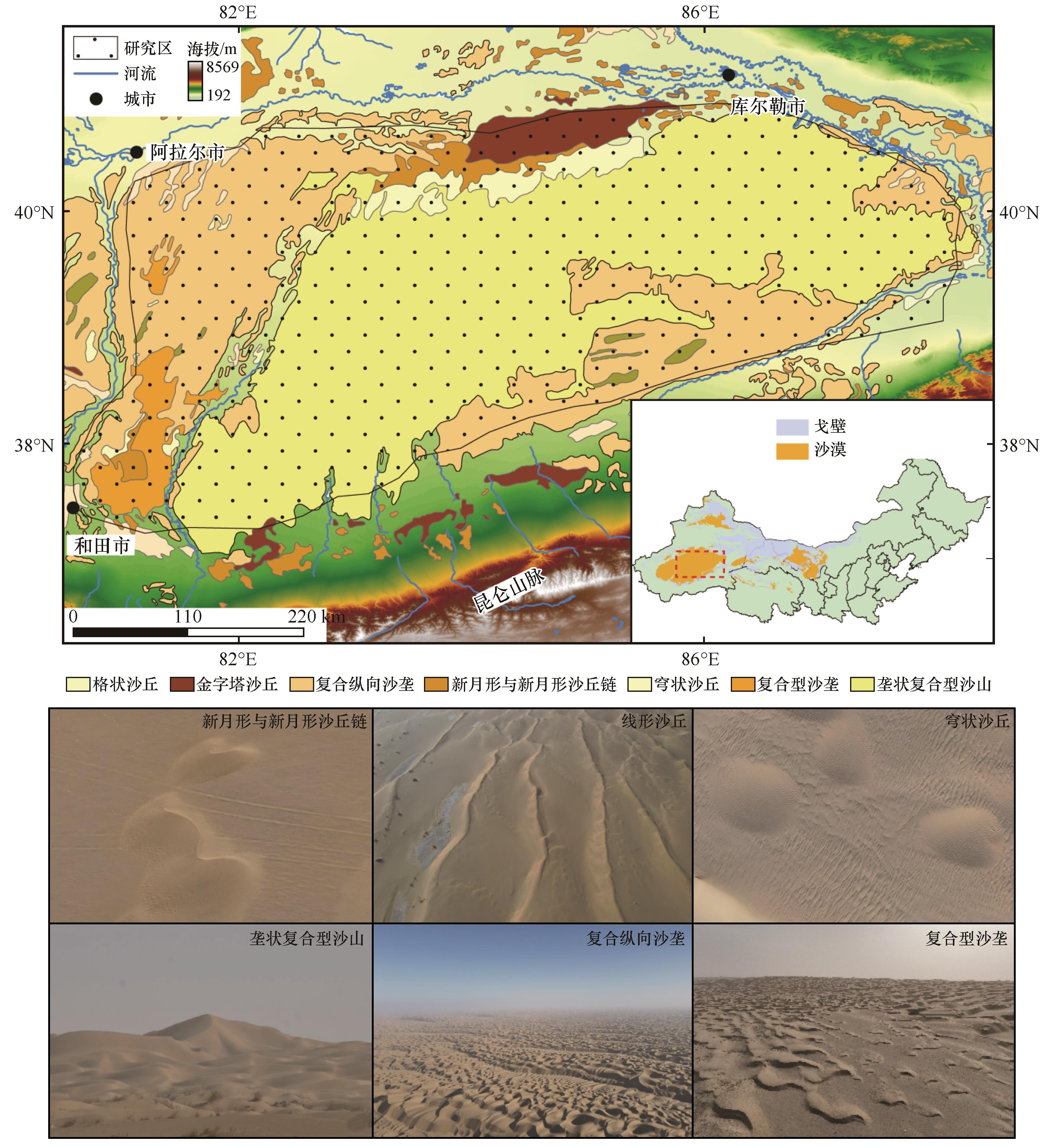
董治宝,苏志珠,钱广强,等.库姆塔格沙漠风沙地貌[M].北京:科学出版社,2011.
|
| [5] |
Li C, Dong Z B, Cui X J,et al.Pattern analysis of simple transverse dunes in China's Qaidam Basin,North of the Kunlun Mountains[J].Environal Earth Science,2016,75:729.
|
| [6] |
Liu J, Liu Y, Wan W H,et al.Orbital and in situ observation of transverse aeolian ridges at Zhurong landing site[J].Journal of Geophysical Research:Planets,2023,128:JE007857.
|
| [7] |
Zheng Z J, Yu J S D, Zhang X Y,et al.Development of a 30 m resolution global sand dune/sheet classification map(GSDS30) using multi-source remote sensing data[J].Remote Sensing of Environment,2024,302:113973.
|
| [8] |
朱震达,陈治平,吴正,等.塔克拉玛干沙漠风沙地貌研究[M].北京:科学出版社,1981.
|
| [9] |
凌裕泉.塔克拉玛干沙漠的流场特征与风沙活动强度的关系[J].中国沙漠,1988,8(2):28-40.
|
| [10] |
李振山,陈广庭.塔克拉玛干沙漠起沙风况[J].中国沙漠,1999,19(1):43-45.
|
| [11] |
俎瑞平,屈建军,方海燕,等.塔克拉玛干沙漠风况特征研究[J].干旱区地理,2005,28(2):167-170.
|
| [12] |
Liu Z Y, Dong Z B, Zhang Z C.Spatial and temporal variation of the near-surface wind regimes in the Taklimakan Desert,Northwest China[J].Theoretical and Applied Climatology,2019,138:433-447.
|
| [13] |
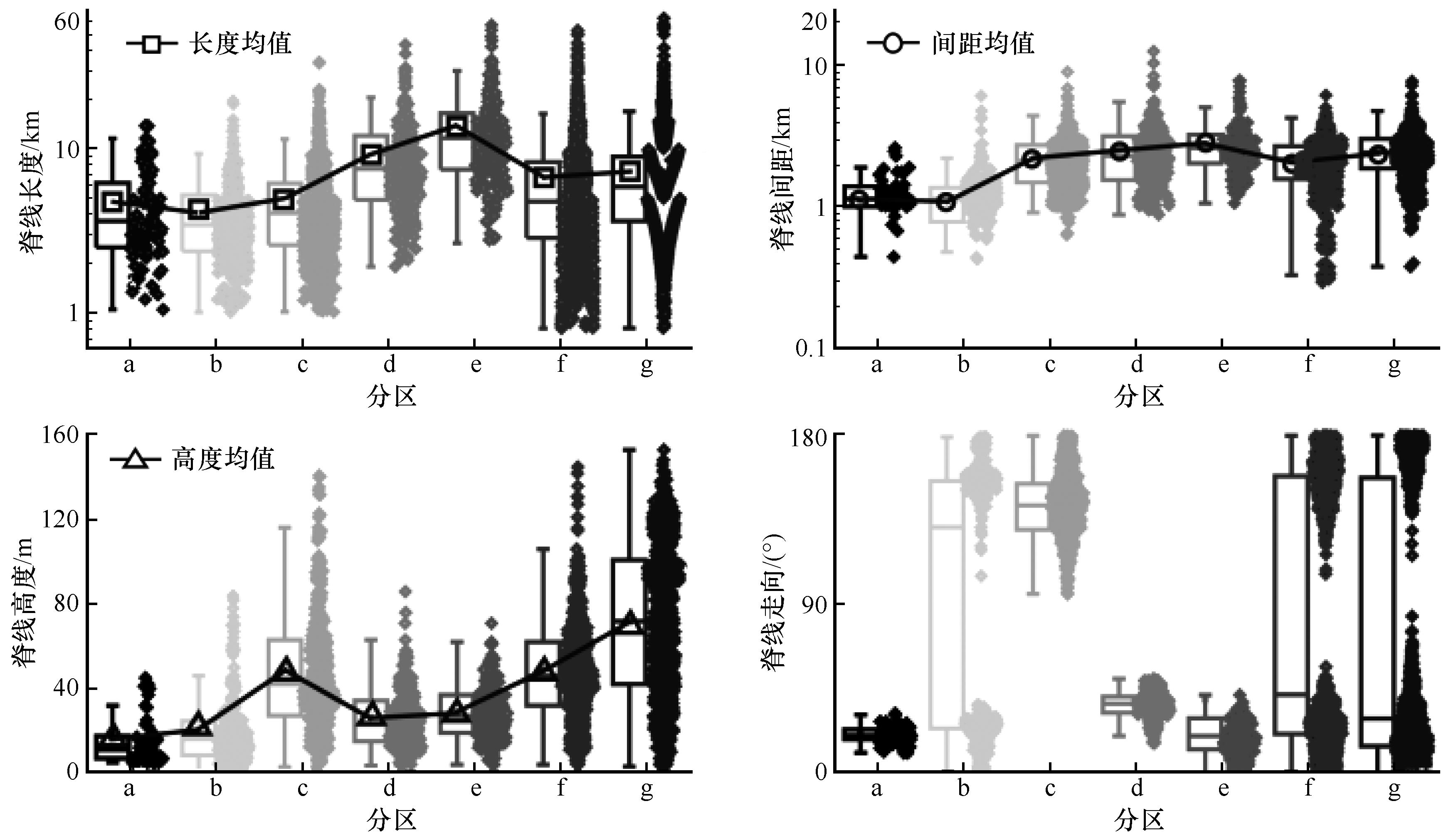
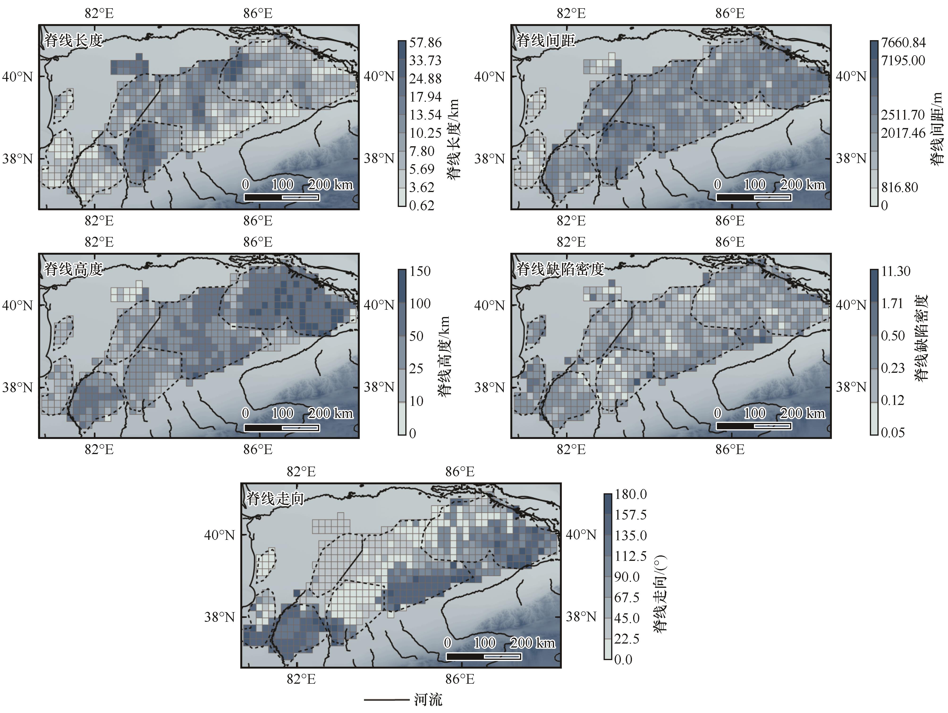
王训明,董治宝,屈建军.塔克拉玛干沙漠简单横向沙丘形态学示量特征[J].兰州大学学报(自然科学版),2002,38(6):110-116.
|
| [14] |
张翰之,鹿化煜,戈双文,等.中国北方沙漠/沙地锆石形态特征及其对物源的指示[J].第四纪研究,2013,33(2):334-344.
|
| [15] |
王宁波,李生字,王海峰,等.塔克拉玛干沙漠腹地垄间地上覆沙丘形态的空间变化特征及其成因[J].干旱区地理,2014,7(1):89-96.
|
| [16] |
Song Q, Gao X, Lei J G,et al.Spatial distribution of sand dunes and their relationship with fluvial systems on the southern margin of the Taklimakan Desert,China[J].Geomatics,Natural Hazards and Risk,2019,10(1):2408-2428.
|
| [17] |
Zhang Z Y, Han L Y, Wang S Q,et al.Provenance of Taklimakan Desert aeolian sediments based on rare earth elements signatures[J].Earth Surface Processes and Landforms,2025,50:e70105.
|
| [18] |
Chen L, Zhang F.Rees spatial distribution of dune sands reveals differences of regional surface processes in the Taklamakan Desert[J].Catena,2025,254:108956.
|
| [19] |
张德二.我国历史时期以来降尘的天气气候学初步分析[J].中国科学(B辑),1984,14(3):278-288.
|
| [20] |
李恒鹏,陈广庭.塔克拉玛干沙漠腹地复合沙垄间地新月形沙丘的逆向演变[J].中国沙漠,1999,19(2):134-138.
|
| [21] |
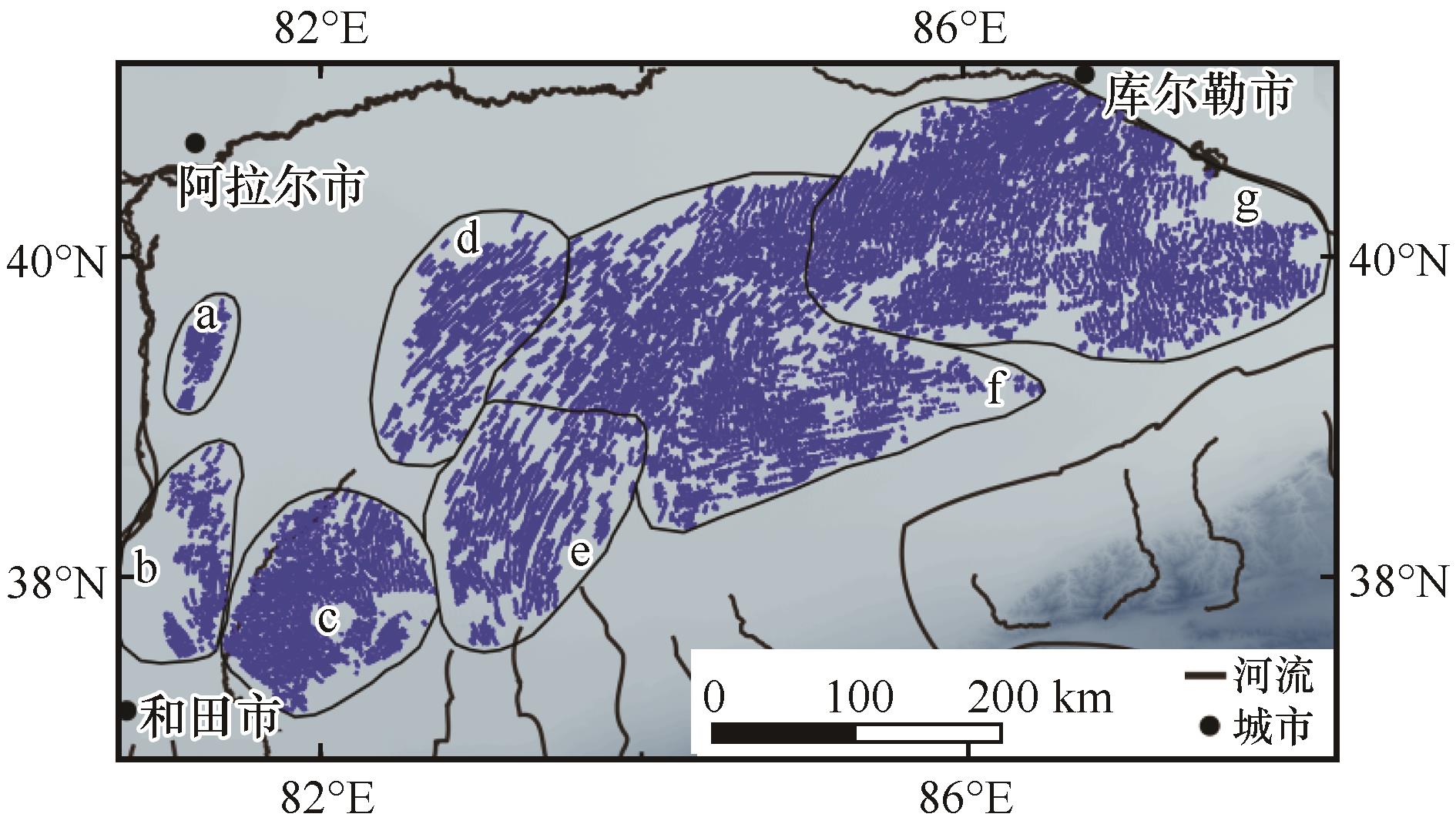
岳健,雷加强,穆桂金.塔克拉玛干沙漠复合纵向沙垄区大尺度地貌格局初步研究[J].科学通报,2008():159-168.
|
| [22] |
刘鑫,高鑫.塔克拉玛干沙漠南缘新月形沙丘移动特征[J].干旱区研究,2024,41(4):661-673.
|
| [23] |
Li H L, Gao X, Zhao Y C,et al.Geomorphology of mega-dunes in the eastern Taklimakan Desert[J].Journal of Geographical Sciences,2025,35(6):1329-1350.
|
| [24] |
Wang H, Jia X.Field observations of windblown sand and dust in the Taklimakan Desert,NW China,and insights into modern dust sources[J].Land Degradation Development,2013,24(4):323-333.
|
| [25] |
Danielson J J, Gesch D B.Global Multi-resolution Terrain Elevation Data 2010(GMTED2010)[DS].U.S.Geological Survey,2011..
|
| [26] |
管超,哈斯额尔敦,安晶,等.库布齐沙漠北部横向沙丘地貌格局的空间变异[J].北京师范大学学报(自然科学版),2015,51():13-22.
|
| [27] |
Sun W T, Gao X.Geomorphology of sand dunes in the Taklamakan Desert based on ERA5 reanalysis data[J].Journal of Arid Environments,2022,207:104848.
|
| [28] |
Ungar J E, Haff P K.Steady state saltation in air[J].Sedimentology,1987,34(2):289-299.
|
| [29] |
Iversen J D, Rasmussen K R.The effect of wind speed and bed slope on sand transport[J].Sedimentology,1999,46(4):723-731.
|
| [30] |
Hugenholtz C H, Barchyn T E.Spatial analysis of sand dunes with a new global topographic dataset:new approaches and opportunities[J].Earth Surface Processes and Landforms,2010,35:986-992.
|
| [31] |
Lancaster N.The Geomorphology of Desert Dunes[M].London,UK:Routledge,1995.
|
| [32] |
Bagnold R.The Physics of Blown Sand and Desert Dunes[M].London,UK:Methuen,1941.
|
| [33] |
McKee E D.Introduction to a study of global sand seas[M]∥McKee E D,ed.A Study of Global Sand Seas.Virginia,USA:USGS,1979.
|
| [34] |
Melton F A.A tentative classification of sand dunes:its application to dune history in the southern High Plains[J].Journal of Geology,1940,48:113-174.
|
| [35] |
Livingstone I, Warren A.Aeolian Geomorphology:An Introduction[M].Essex,UK:Longman,1996.
|
| [36] |
Zheng X J, Bo T L, Zhu W.A scale-coupled method for simulation of the formation and evolution of aeolian dune field[J].International Journal of Nonlinear Sciences and Numerical Simulation,2009,10:387-395.
|
| [37] |
Wasson R J, Hyde R.Factors determining desert dune type[J].Nature,1983,304:337-339.
|
 ), 张正偲3(
 甘公网安备 62010202000688号