img

官方微信

高级检索

中国沙漠 ›› 2026, Vol. 46 ›› Issue (3): 371-380.DOI: 10.7522/j.issn.1000-694X.2025.00297

• • 上一篇    

雅鲁藏布江中游地区典型沙地沙尘传输特征

吴培浠(), 赵媛媛(), 陈江波, 阎水明, 丁国栋   

  1. 北京林业大学 水土保持学院,北京 100083
  • 收稿日期:2025-10-22 修回日期:2025-12-16 出版日期:2026-05-20 发布日期:2026-06-11
  • 通讯作者: 赵媛媛
  • 作者简介:吴培浠(2001—),女,天津人,硕士研究生,主要从事风蚀荒漠化研究。E-mail: wupeixi1221@163.com.
  • 基金资助:
    中央高校基本科研业务费专项(PTYX202526);中央高校基本科研业务费专项(PTYX202530);中央高校基本科研业务费专项(PTYX202533)

Dust transport characteristics in typical sandy lands of the middle reaches of the Yarlung Zangbo River

Peixi Wu(), Yuanyuan Zhao(), Jiangbo Chen, Shuiming Yan, Guodong Ding   

  1. College of Soil and Water Conservation,Beijing Forestry University,Beijing 100083,China
  • Received:2025-10-22 Revised:2025-12-16 Online:2026-05-20 Published:2026-06-11
  • Contact: Yuanyuan Zhao

摘要:

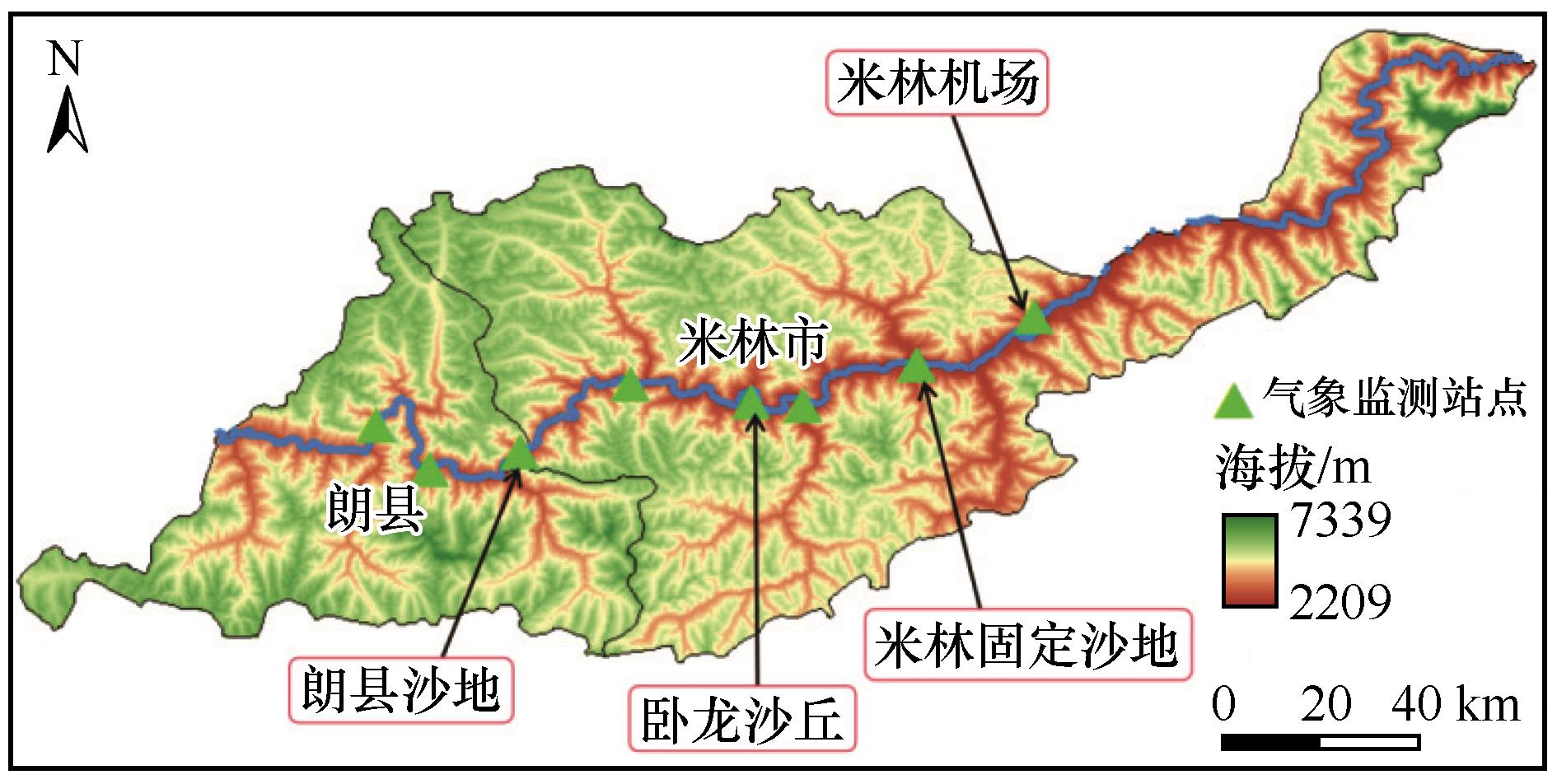
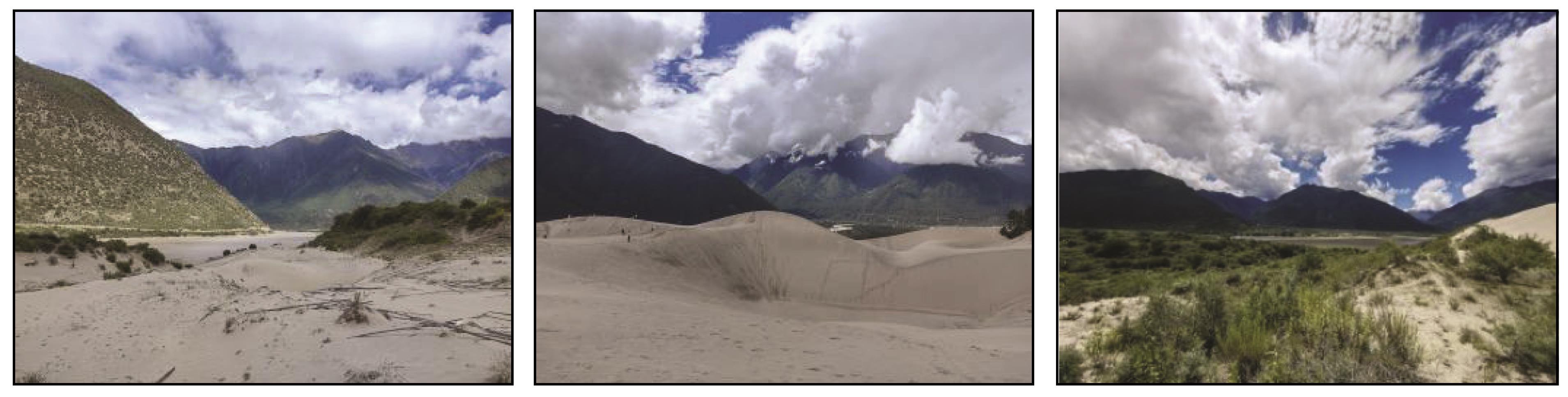
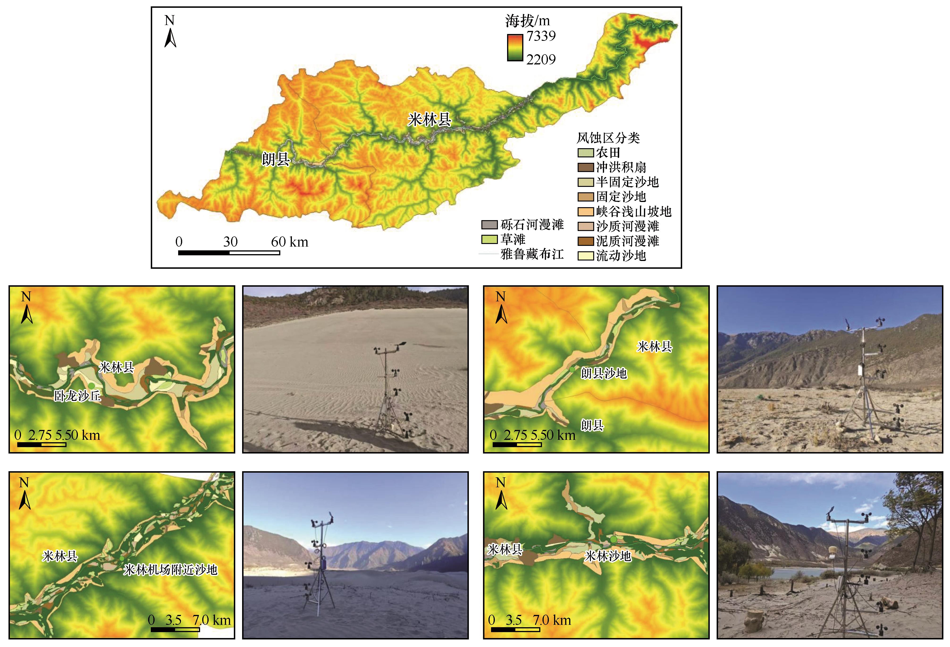
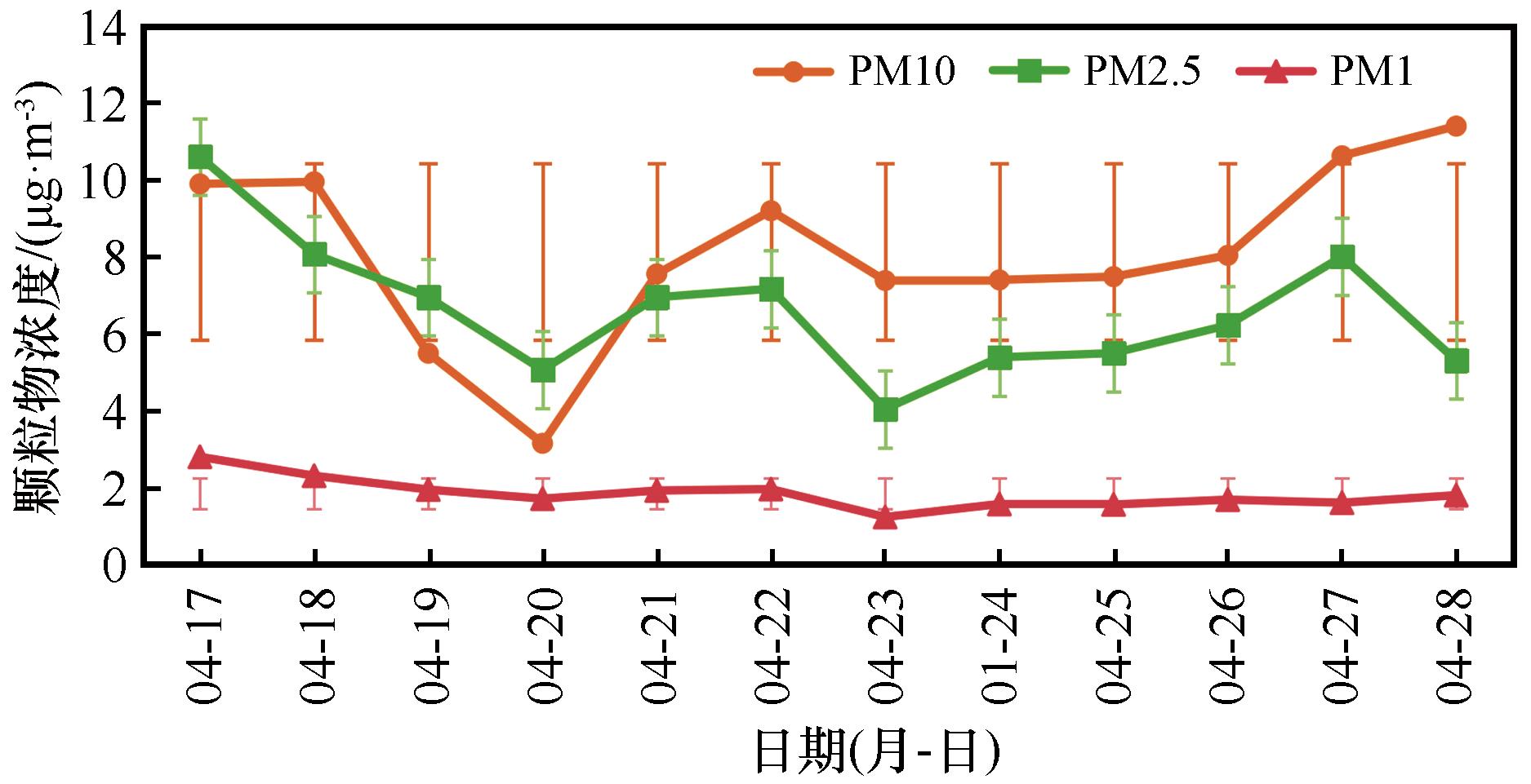
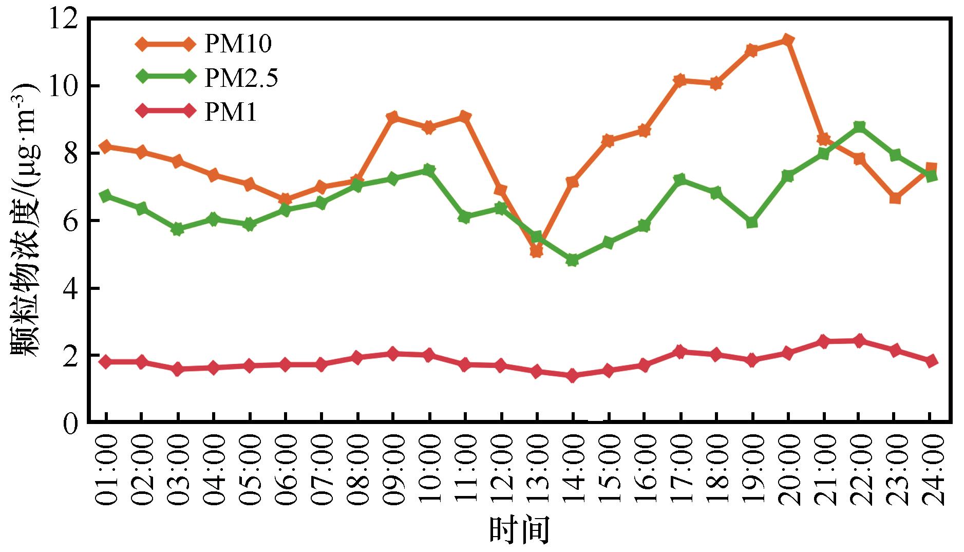
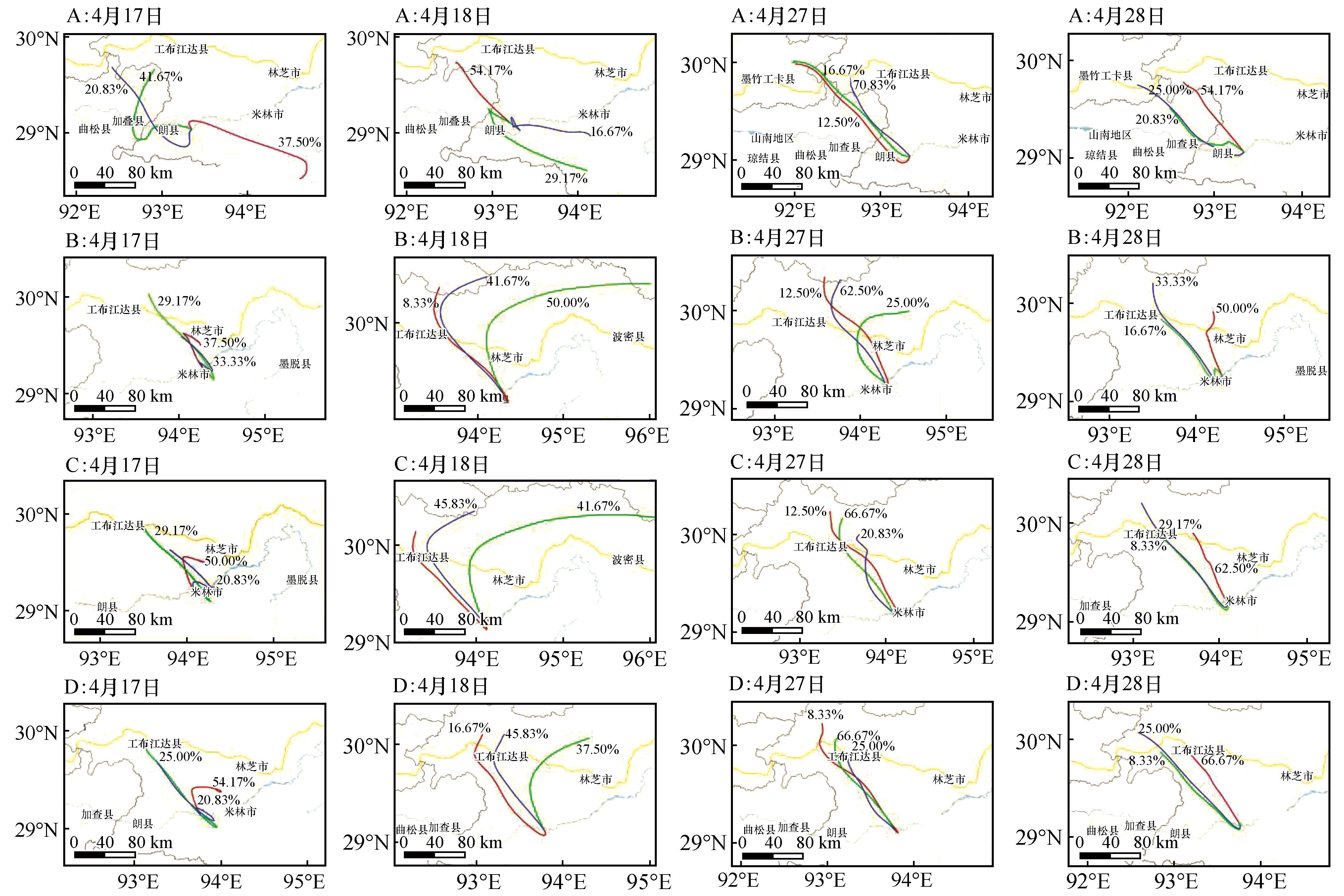
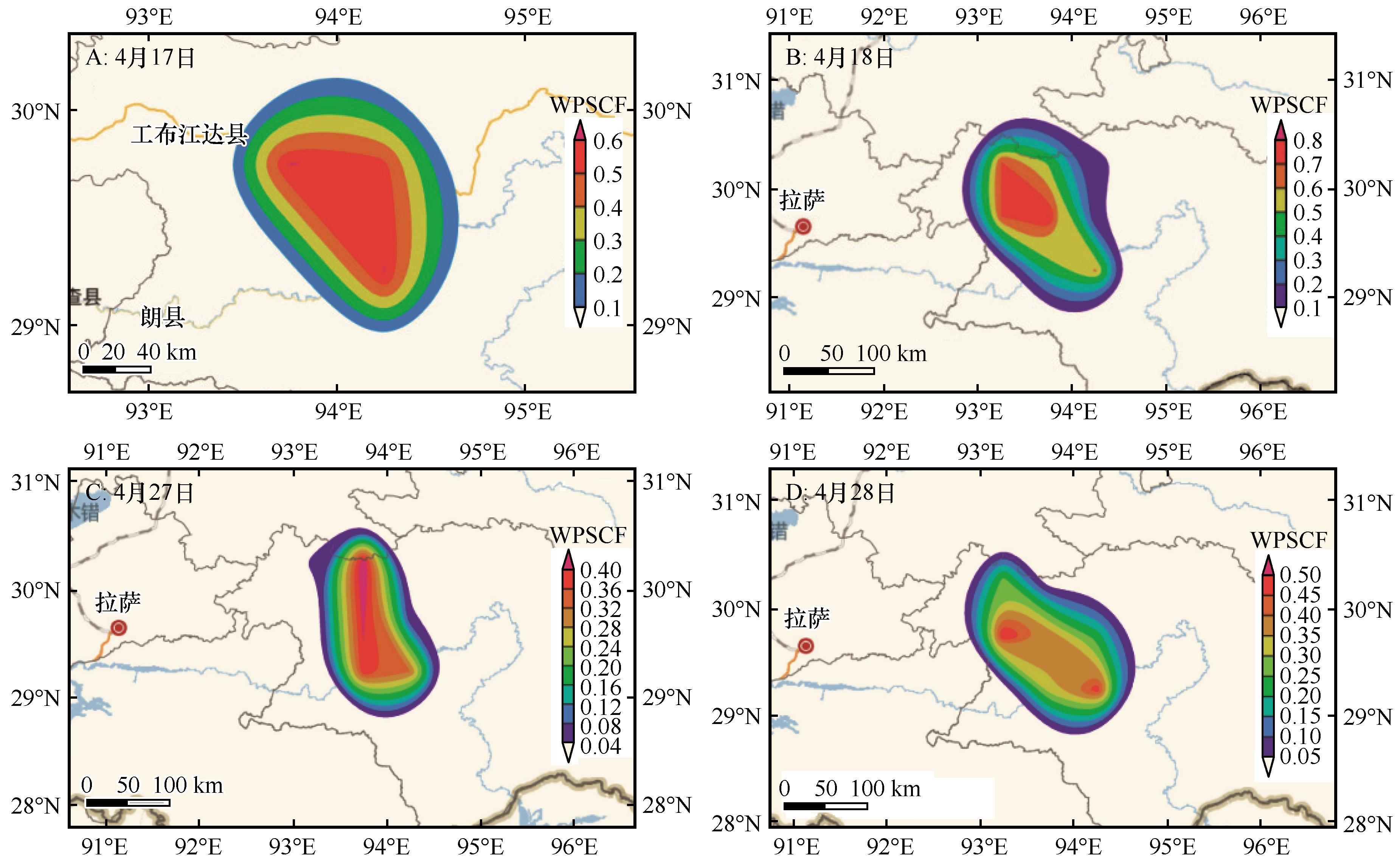
本研究旨在评估雅鲁藏布江(以下简称雅江)沿岸沙丘分布与沙尘传输对流域内重要经济区的影响,为区域沙尘污染精准防控提供科学依据。研究聚焦于雅江中游典型沙丘区,综合运用地面颗粒物监测、HYSPLIT与Meteoinfo轨迹模拟及PSCF沙尘污染物扩散分析,系统揭示了沙尘传输的时空特征与环境影响范围。结果表明:(1)雅江河谷区核心风蚀带总面积为416.35 km2,其中流动沙地面积为11 km2,半固定沙地面积为32.42 km2,固定沙地面积为39.67 km2。(2)每日颗粒物浓度呈双峰分布,主峰(17:00—22:00)与次峰(09:00—10:00)为沙尘活跃时段,凌晨和午间空气质量较好;PM10日极差达8.23 μg·m-3,易受局地风扰;PM2.5与PM1日极差分别为6.55 μg·m-3和1.56 μg·m-3,反映不同粒径尺度对气候相应敏感度有所差别;(3)典型风沙季节沙尘事件轨迹聚类表明,西北方向(频率38.36%)与西北北方向(频率20.55%)为关键输送路径,其中西北北路径气团占比48.21%且PM10浓度最高(10.36 μg·m-3);(4)PSCF模型识别出13个沙尘高风险村落,包括朗村、阿沛村、米林镇等,其中帕朗莎村与达帕莎村位于西北路径核心影响区。雅江中游沙尘传输具有明显的方向性与时段集中性,沿岸特定村落为沙尘释放与传输的关键节点,需实施重点防控。

关键词: 雅鲁藏布江, 沙源地, 沙尘传输, Meteoinfo, 颗粒物浓度

Abstract:

This study aims to evaluate the impact of dune distribution and dust transport along the Yarlung Zangbo River (hereinafter referred to as the YZR) on important economic zones within the basin, providing a scientific basis for precise prevention and control of regional dust pollution. Focusing on typical dune areas in the middle reaches of the YZR, this research comprehensively utilized ground-level particulate matter monitoring, HYSPLIT and Meteoinfo backward trajectory simulations, and PSCF analysis of dust pollutant dispersion to systematically reveal the spatiotemporal characteristics of dust transport and its environmental impact range. The main findings include: (1)The total area of the core wind erosion zone in the Yarlung Zangbo River Valley amounts to 416.35 km2, including 11 km² of mobile sandy land, 32.42 km2 of semi-fixed sandy land, and 39.67 km2 of fixed sandy land. (2) Daily particulate matter concentrations showed a bimodal distribution, with the primary peak (17:00-22:00) and secondary peak (09:00-10:00) indicating periods of high dust activity, while air quality was better in the early morning and at noon; the daily range of PM10 reached 8.23 μg·m-3, indicating high susceptibility to local wind disturbances; the daily ranges of PM2.5 and PM1 were 6.55 μg·m-3 and 1.56 μg·m-3, respectively, reflecting varying sensitivity to climatic conditions across different particle size scales. (3) Trajectory clustering analysis of a dust event in April 2024 revealed that NW (frequency 38.36%) and NNW (frequency 20.55%) were the key transport pathways, with the NNW pathway accounting for 48.21% of air masses and exhibiting the highest PM10 concentration (10.36 μg·m-3). (4) The PSCF model identified 13 villages at high risk of dust impact, including Lang Village, Apê Village, and Mainling Town, with Palungsha Village and Dapasha Village located in the core influence area of the NW pathway. Dust transport in the middle reaches of the YZR exhibits distinct directionality and temporal concentration, with specific villages along the river serving as key nodes for dust emission and transport, necessitating targeted prevention and control measures. This study provides theoretical support and spatial guidance for air quality management and ecological protection in the YZR economic belt.

Key words: Yarlung Zangbo River, dust source region, dust transport, Meteoinfo, particulate matter concentration

中图分类号: