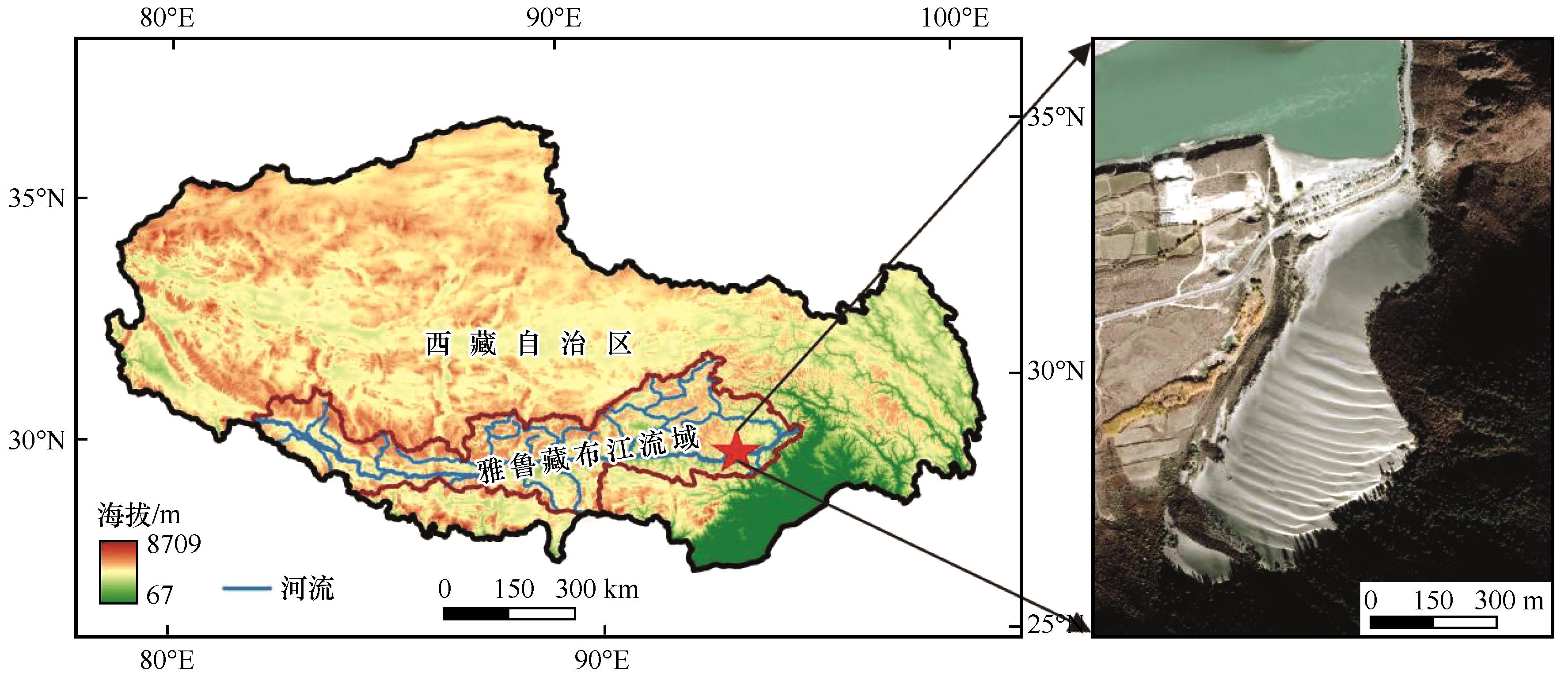
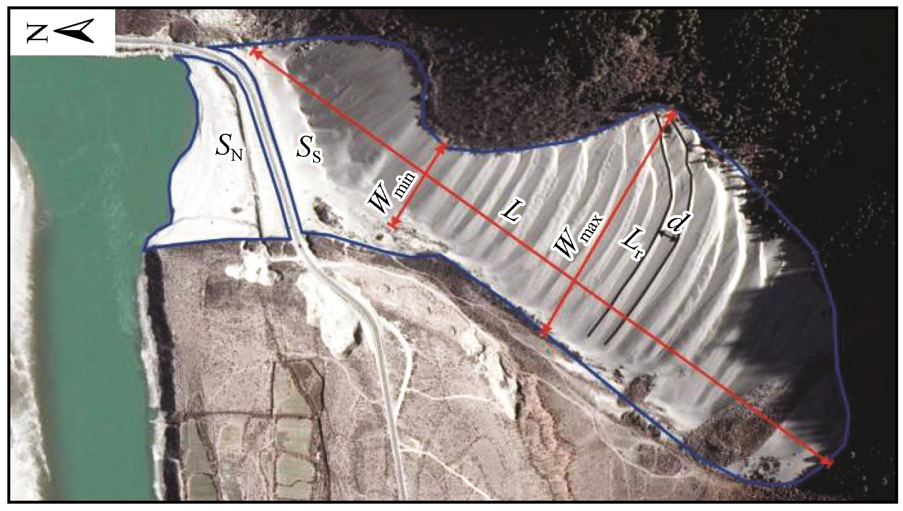
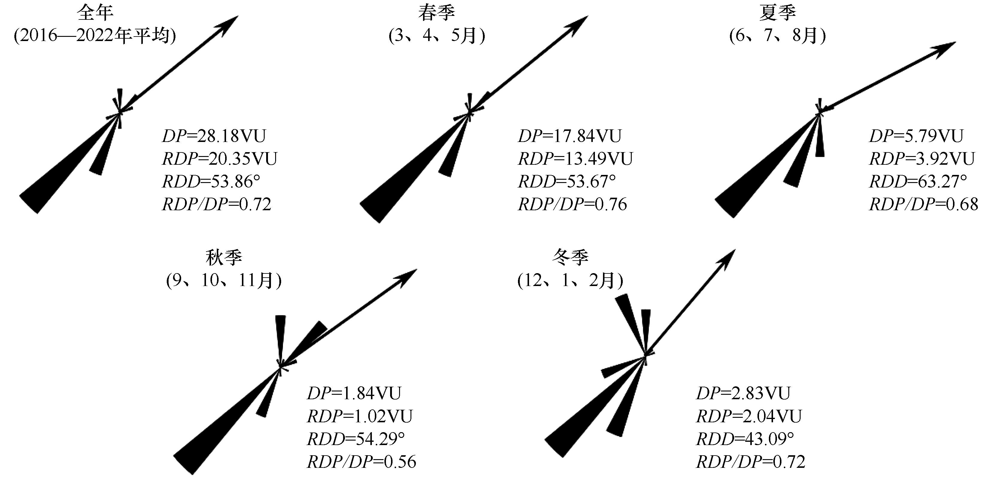
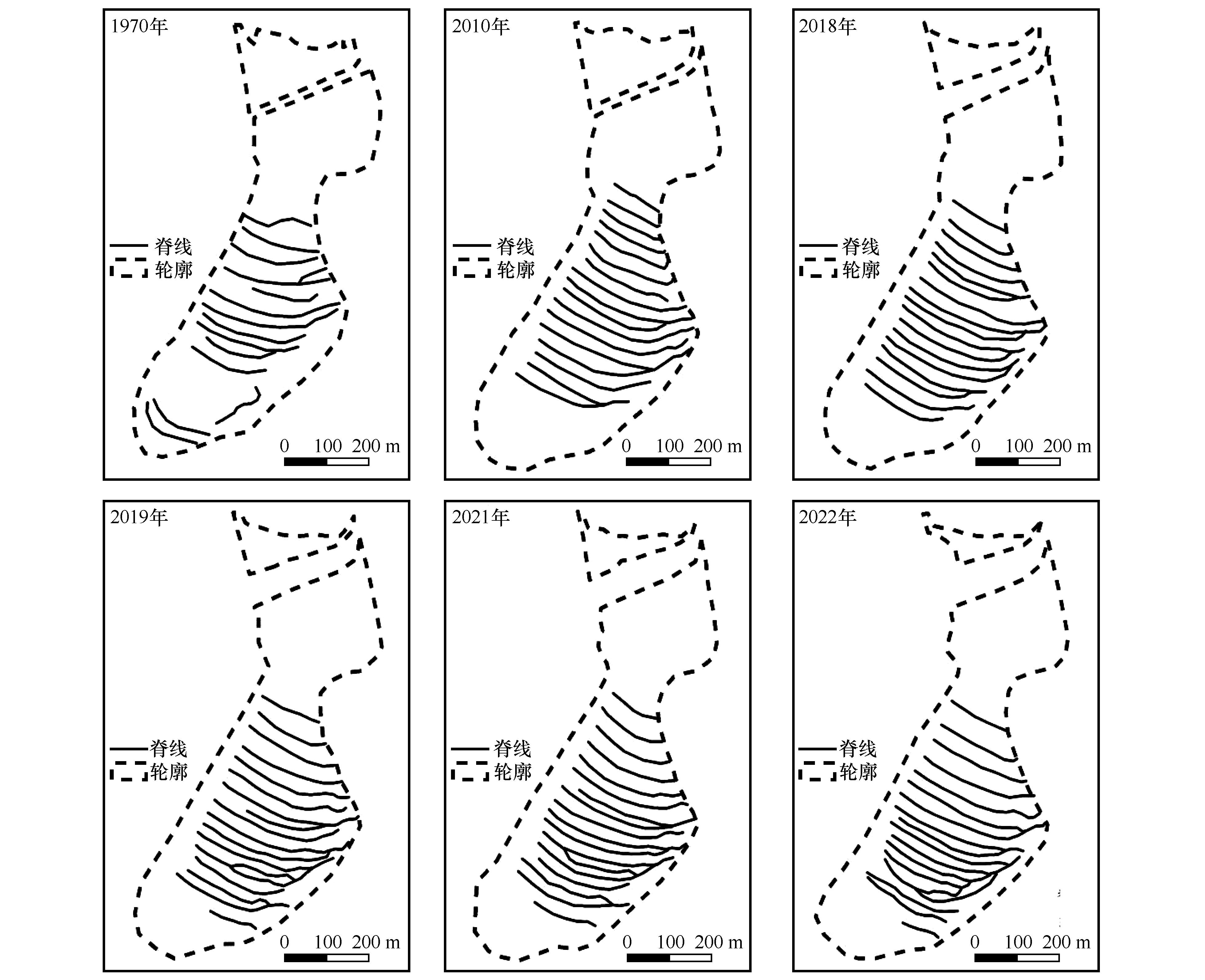
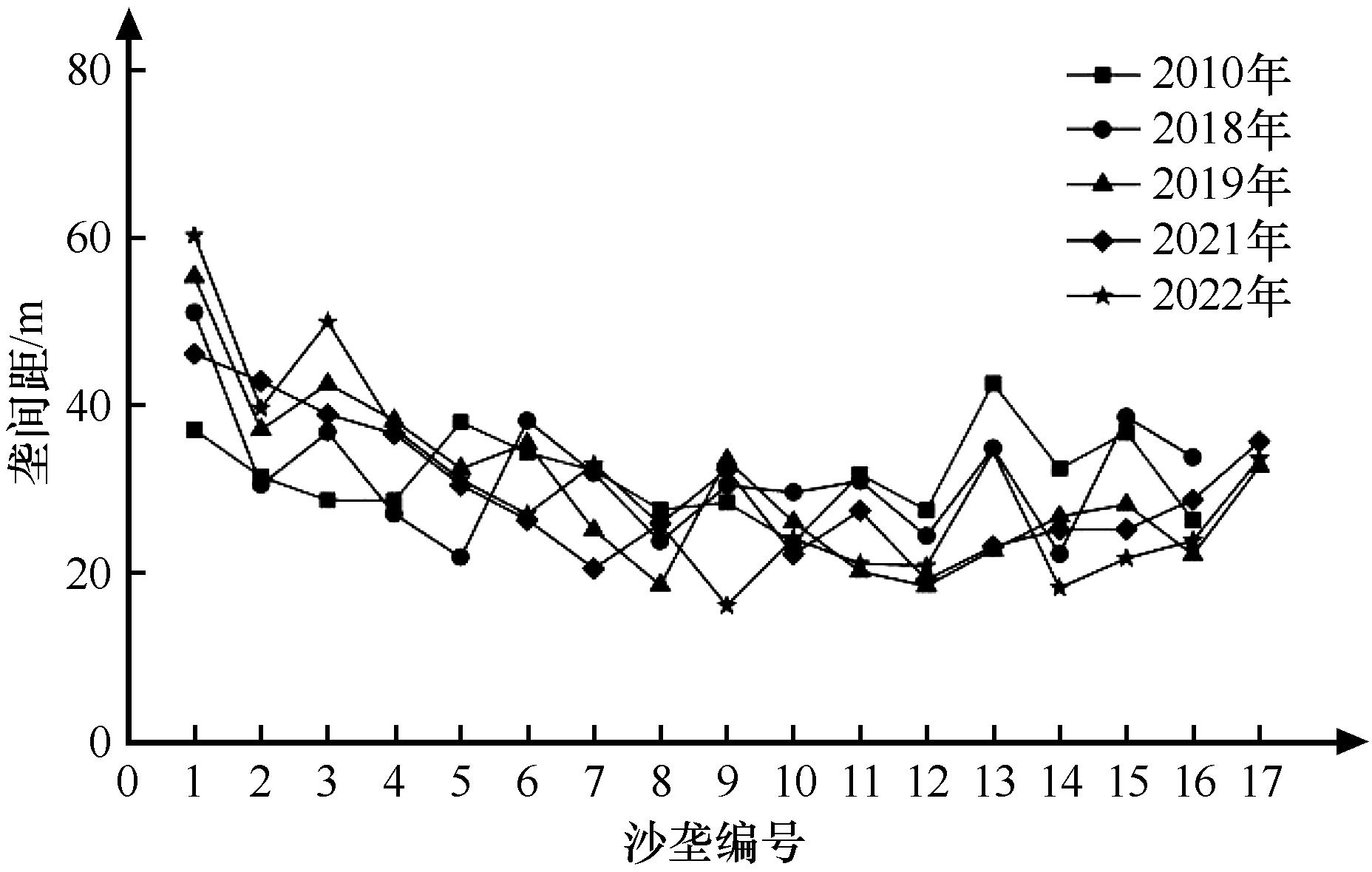
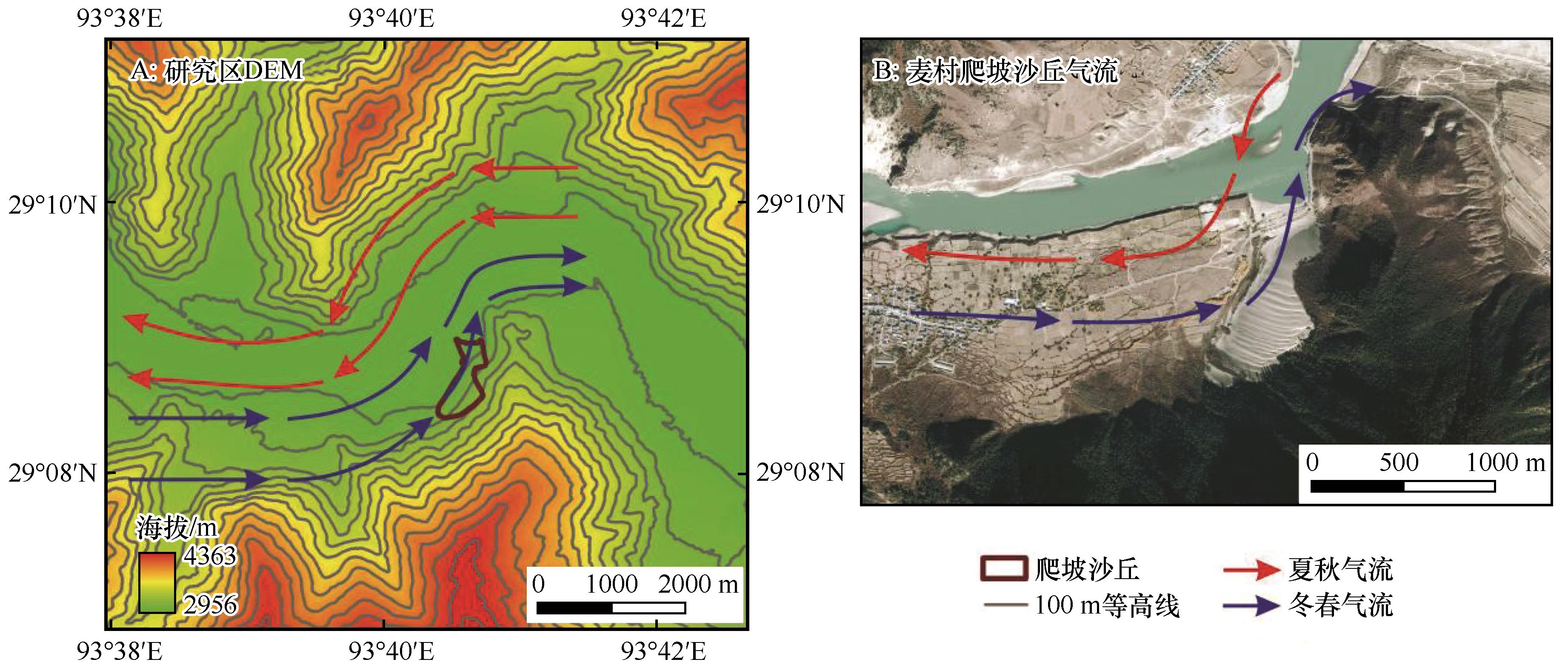
| 1 |
李森,董光荣,董玉祥,等.西藏“一江两河”中部流域地区土地沙漠化防治目标、对策与治沙工程布局[J].中国沙漠,1994,14(2):55-63.
|
| 2 |
杨逸畴,高登义,李渤生.雅鲁藏布江下游河谷水汽通道初探[J].中国科学:B辑,1987,17(8):893-902.
|
| 3 |
李森,王跃,哈斯,等.雅鲁藏布江河谷风沙地貌分类与发育问题[J].中国沙漠,1997,17(4):10-18.
|
| 4 |
朱震达,吴正,李钜章,等.塔克拉玛干沙漠风沙地貌研究[J].科学通报,1966(13):620-624.
|
| 5 |
黄鹏展,阿布都热西提·阿布都外力,赵建平.沙丘移动的研究现状与未来研究思路[J].沙漠与绿洲气象,2010,4(1):1-5.
|
| 6 |
王宁波,李生宇,王海峰,等.塔克拉玛干沙漠腹地垄间地上覆沙丘形态的空间变化特征及其成因[J].干旱区地理,2014,37(1):89-96.
|
| 7 |
杨军怀.塔克拉玛干沙漠沙丘移动研究[D].西安:陕西师范大学,2019.
|
| 8 |
李爱敏,韩致文.新月形沙丘形态参数与移动速度的关系[J].中国沙漠,2020,40(1):29-40.
|
| 9 |
刘鑫,高鑫.塔克拉玛干沙漠南缘新月形沙丘移动特征[J].干旱区研究,2024,41(4):661-673.
|
| 10 |
任孝宗,王嵩松,王亚梅,等.浑善达克沙地西部新月形沙丘和抛物线沙丘共存区的地貌特征[J].干旱区研究,2023,40(12):2016-2030.
|
| 11 |
杨馥宁,吕萍,马芳,等.腾格里沙漠南部格状沙丘的形态演变及移动特征[J].中国沙漠,2023,43(1):107-115.
|
| 12 |
董苗,严平,王晓旭,等.青藏高原不同气候带爬坡沙丘沉积物特征及其环境指示[J].地理学报,2023,78(7):1825-1846.
|
| 13 |
王晓枝,董治宝,南维鸽,等.拉萨河谷爬坡沙丘沉积物特征[J].中国沙漠,2022,42(4):22-31.
|
| 14 |
田伟东,杨军怀,王树源,等.雅鲁藏布江河谷沙丘沉积物粒度特征及其环境指示[J].干旱区资源与环境,2022,36(1):128-134.
|
| 15 |
周娜,张春来,刘永刚.雅鲁藏布江米林宽谷段爬升沙丘粒度分异特征研究[J].地理研究,2012,31(1):82-94.
|
| 16 |
刘婷,贾晓鹏,陈定梅,等.雅鲁藏布江中游平坦流沙地表空气动力学特征[J].中国沙漠,2023,43(5):194-203.
|
| 17 |
Yang J H, Xia D S, Wang S Y,et al.Near-surface wind environment in the Yarlung Zangbo River basin,southern Tibetan Plateau[J].Journal of Arid Land,2020,12(6):917-936.
|
| 18 |
Fryberger S G.Dune forms and wind regime[M]//McKee E D.A study of Global Sand Seas.Washington,USA:U.S.SurveyGeological,1979:137-169.
|
| 19 |
贾光普.阿拉善戈壁地区新月形沙丘形态特征与动态演变过程研究[D].呼和浩特:内蒙古农业大学,2022.
|
| 20 |
许明静,吕萍,肖南,等.毛乌素沙地西北部植被覆盖对沙丘移动的影响[J].中国沙漠,2020,40(4):71-80.
|
| 21 |
Norri R M.Barchan dunes of Imperial Valley,California[J].The Journal of Geology,1966,74(3):292.
|
| 22 |
王嵩松.基于遥感影像的新月形沙丘动态监测[J].科技和产业,2023,23(6):187-191.
|
| 23 |
朱震达,郭恒文,吴功成.塔克拉玛干沙漠西南地区绿洲附近沙丘移动的研究[J].地理学报,1964(1):35-50.
|
| 24 |
马鹏飞,张正偲,论珠群培,等.雅鲁藏布江曲水-泽当段风沙活动动力条件分析与风沙灾害防治建议[J].中国沙漠,2021,41(1):10-18.
|
| 25 |
秦豪君,杨晓军,马莉,等.2000-2020年中国西北地区区域性沙尘暴特征及成因[J].中国沙漠,2022,42(6):53-64.
|
| 26 |
Rasmussen K R.Some aspects of flow over coastal dunes[J].Proceedings of the Royal Society of Edinburgh Section B-Biological Sciences,1989,96:129-147.
|
| 27 |
Arens S M.Transport rates and volume changes in a coastal foredune on a dutch wadden island[J].Journal of Coastal Conservation,1997,3(1):49-56.
|
| 28 |
White B R, Tsoar H.Slope effect on saltation over a climbing sand dune[J].Geomorphology,1998,22(2):159-180.
|
| 29 |
李森,董光荣,申建友,等.雅鲁藏布江河谷风沙地貌形成机制与发育模式[J].中国科学(D辑:地球科学),1999(1):88-96.
|
| 30 |
杨军怀,夏敦胜,高福元,等.雅鲁藏布江流域风成沉积研究进展[J].地球科学进展,2020,35(8):863-877.
|
| 31 |
Rendell H M, Clarke M L, Warren A,et al.The timing of climbing dune formation in southwestern Niger:fluvio-aeolian interactions and the role of sand supply[J].Quaternary Science Reviews,2003,22(10/13):1059-1065.
|
| 32 |
Blight,Geoffrey,Blight,et al.South Africa's mountain-climbing sand dunes mechanism of formation and present status[J].Civil Engineering:Magazine of the South African Institution of Civil Engineering,2013,21(7):11-19.
|
| 33 |
落桑曲加,张焱,马鹏飞,等.雅鲁藏布江中游不同地表输沙量特征[J].中国沙漠,2022,42(2):6-13.
|
| 34 |
管超,武子丰,哈斯额尔敦.库布齐沙漠西缘格状沙丘动态特征及其成因[J].中国沙漠,2024,44(2):239-253.
|
| 35 |
夏敦胜,杨军怀,王树源,等.雅鲁藏布江流域风成沉积空间格局、沉积模式及其环境效应[J].地学前缘,2023,30(4):229-244.
|
| 36 |
乌友罕,殷婕,武子丰,等.巴丹吉林-乌兰布和沙漠输沙带新月形沙丘动态[J].中国沙漠,2024,44(2):78-89.
|
| 37 |
邹桐,杨转玲,韦锦芝,等.柴达木盆地西南缘新月形沙丘移动特征及其影响因素[J].中国沙漠,2023,43(1):212-221.
|
| 38 |
王瑞明,张晓东,李帅,等.某受地形阻挡风场的CFD数值模拟[J].风能,2023(10):68-76.
|
| 39 |
张正偲,董治宝.风沙地貌形态动力学研究进展[J].地球科学进展,2014,29(6):734-747.
|
| 40 |
孙赫,苏凤阁,黄敬恒,等.第三极西风和季风主导流域源区降水呈现不同梯度特征[J].科学通报,2020,65(1):91-104.
|
| 41 |
Yang Z L, Qian G Q, Dong Z B,et al.Migration of barchan dunes and factors that influence migration in the Sanlongsha dune field of the northern Kumtagh Sand Sea,China[J].Geomorphology,2021,378:107615.
|
| 42 |
Bogle R, Redsteer H M, Vogel J.Field measurement and analysis of climatic factors affecting dune mobility near Grand Falls on the Navajo Nation,southwestern United States[J].Geomorphology,2015,228:41-51.
|
| 43 |
杨军怀,董治宝,刘铮瑶,等.库鲁克沙漠风沙地貌与沙丘移动[J].中国沙漠,2019,39(4):1-8.
|
 ), 严平2(
 甘公网安备 62010202000688号