
- CN 62-1070/P
- ISSN 1000-694X
- Bimonthly 1981
Journal of Desert Research ›› 2022, Vol. 42 ›› Issue (4): 99-109.DOI: 10.7522/j.issn.1000-694X.2021.00214
Previous Articles Next Articles
Jing Luo1( ), Xiaoxia Huang1(), Hong Cheng2(), Ning Jiang2, Xuyu Mo3, Xiuyu Wang1
Received:2021-09-29
Revised:2021-12-12
Online:2022-07-20
Published:2022-08-29
Contact:
Xiaoxia Huang,Hong Cheng
CLC Number:
Jing Luo, Xiaoxia Huang, Hong Cheng, Ning Jiang, Xuyu Mo, Xiuyu Wang. Impacts of landscape structure changes on ecosystem services in the Hunshandake Sandy Land[J]. Journal of Desert Research, 2022, 42(4): 99-109.
Add to citation manager EndNote|Ris|BibTeX
URL: http://www.desert.ac.cn/EN/10.7522/j.issn.1000-694X.2021.00214

Fig.1 Overview map of Hunshandake Sandy Land
| 数据指标 | 数据来源 | 分辨率 | 说明 | 支持的ES指标 | ES类型 |
|---|---|---|---|---|---|
| DEM | SRTM https://cgiarcsi.community/ | 90 m×90 m | 在ArcGIS v10.2生成坡向、坡度、坡长栅格数据 | 土壤风蚀防治 土壤水蚀防治 植被固碳 土壤碳存储 | 生态调节 |
| 气象数据 | 中国气象科学数据共享网 http://data.cma.cn | 2000年和2015年月度数据 | 在ArcGIS v10.2中进行kriging插值,得到250 m×250 m的气象数据栅格 | ||
| NDVI数据 | MODIS https://earthdata.nasa.gov/ | 250 m×250 m 16 d间隔 | Terra Vegetation Indices陆地植被指数产品 | ||
| 土壤属性数据 | SoilGrids https://www.isric.org/ | 250 m×250 m | 土壤类型、土壤质地、土壤水分、土壤有机质含量 | ||
| 粮食产量 | 内蒙古自治区统计年鉴 | 旗/县 | 2000年和2015年数据 | 粮食生产 | 生态供给 |
| 牲畜养殖量 | 内蒙古自治区统计年鉴 | 旗/县 | 2000年和2015年数据 | 牲畜养殖 | |
| 人口统计数据 | 内蒙古自治区统计年鉴 | 旗/县 | 2000年和2015年数据 | 人口居住支持 | 生境支持 |
| 土地利用类型 | 中国科学院遥感研究所 | 30 m×30 m | 2000年和2015年数据 | 生境多样性支持 | |
| 行政区划数据 | 生态环境部卫星环境应用中心 | 乡镇/苏木 | 作为计算的基本统计单元 | 生态系统服务复合指数 | 综合指标 |
Table 1 Datasets and sources used in this study, for ecosystem services (ES) analysis
| 数据指标 | 数据来源 | 分辨率 | 说明 | 支持的ES指标 | ES类型 |
|---|---|---|---|---|---|
| DEM | SRTM https://cgiarcsi.community/ | 90 m×90 m | 在ArcGIS v10.2生成坡向、坡度、坡长栅格数据 | 土壤风蚀防治 土壤水蚀防治 植被固碳 土壤碳存储 | 生态调节 |
| 气象数据 | 中国气象科学数据共享网 http://data.cma.cn | 2000年和2015年月度数据 | 在ArcGIS v10.2中进行kriging插值,得到250 m×250 m的气象数据栅格 | ||
| NDVI数据 | MODIS https://earthdata.nasa.gov/ | 250 m×250 m 16 d间隔 | Terra Vegetation Indices陆地植被指数产品 | ||
| 土壤属性数据 | SoilGrids https://www.isric.org/ | 250 m×250 m | 土壤类型、土壤质地、土壤水分、土壤有机质含量 | ||
| 粮食产量 | 内蒙古自治区统计年鉴 | 旗/县 | 2000年和2015年数据 | 粮食生产 | 生态供给 |
| 牲畜养殖量 | 内蒙古自治区统计年鉴 | 旗/县 | 2000年和2015年数据 | 牲畜养殖 | |
| 人口统计数据 | 内蒙古自治区统计年鉴 | 旗/县 | 2000年和2015年数据 | 人口居住支持 | 生境支持 |
| 土地利用类型 | 中国科学院遥感研究所 | 30 m×30 m | 2000年和2015年数据 | 生境多样性支持 | |
| 行政区划数据 | 生态环境部卫星环境应用中心 | 乡镇/苏木 | 作为计算的基本统计单元 | 生态系统服务复合指数 | 综合指标 |
| 年份 | 分区 | 面积/km2 | |||||
|---|---|---|---|---|---|---|---|
| 林地 | 草地 | 耕地 | 建设用地 | 水体/湿地 | 沙地 | ||
| 2000 | 南部 | 185.1 | 1 915.9 | 1 127.8 | 44.0 | 92.5 | 58.4 |
| 西部 | 743.9 | 26 224.8 | 35.9 | 82.5 | 86.9 | 651.9 | |
| 中部 | 3 607.0 | 37 838.8 | 674.0 | 1 249.2 | 346.5 | 1 954.5 | |
| 东部 | 3 196.6 | 9 082.4 | 804.9 | 445.2 | 97.1 | 627.8 | |
| 全区 | 7 732.5 | 75 061.8 | 2 642.6 | 1 820.9 | 623.0 | 3 292.6 | |
| 2015 | 南部 | 75.0 | 1722.5 | 1369.4 | 54.7 | 147.7 | 54.3 |
| 西部 | 593.6 | 24 136.5 | 68.7 | 186.8 | 134.5 | 2 705.7 | |
| 中部 | 1 621.6 | 37 798.0 | 759.7 | 1 490.9 | 605.1 | 3 394.0 | |
| 东部 | 2 450.5 | 9371.2 | 899.6 | 504.3 | 262.3 | 766.4 | |
| 全区 | 4 740.6 | 73 028.2 | 3 097.4 | 2 236.7 | 1 149.7 | 6 920.4 | |
Table 2 Land use composition in Hunshandak Sandy Land in 2000 and 2015
| 年份 | 分区 | 面积/km2 | |||||
|---|---|---|---|---|---|---|---|
| 林地 | 草地 | 耕地 | 建设用地 | 水体/湿地 | 沙地 | ||
| 2000 | 南部 | 185.1 | 1 915.9 | 1 127.8 | 44.0 | 92.5 | 58.4 |
| 西部 | 743.9 | 26 224.8 | 35.9 | 82.5 | 86.9 | 651.9 | |
| 中部 | 3 607.0 | 37 838.8 | 674.0 | 1 249.2 | 346.5 | 1 954.5 | |
| 东部 | 3 196.6 | 9 082.4 | 804.9 | 445.2 | 97.1 | 627.8 | |
| 全区 | 7 732.5 | 75 061.8 | 2 642.6 | 1 820.9 | 623.0 | 3 292.6 | |
| 2015 | 南部 | 75.0 | 1722.5 | 1369.4 | 54.7 | 147.7 | 54.3 |
| 西部 | 593.6 | 24 136.5 | 68.7 | 186.8 | 134.5 | 2 705.7 | |
| 中部 | 1 621.6 | 37 798.0 | 759.7 | 1 490.9 | 605.1 | 3 394.0 | |
| 东部 | 2 450.5 | 9371.2 | 899.6 | 504.3 | 262.3 | 766.4 | |
| 全区 | 4 740.6 | 73 028.2 | 3 097.4 | 2 236.7 | 1 149.7 | 6 920.4 | |
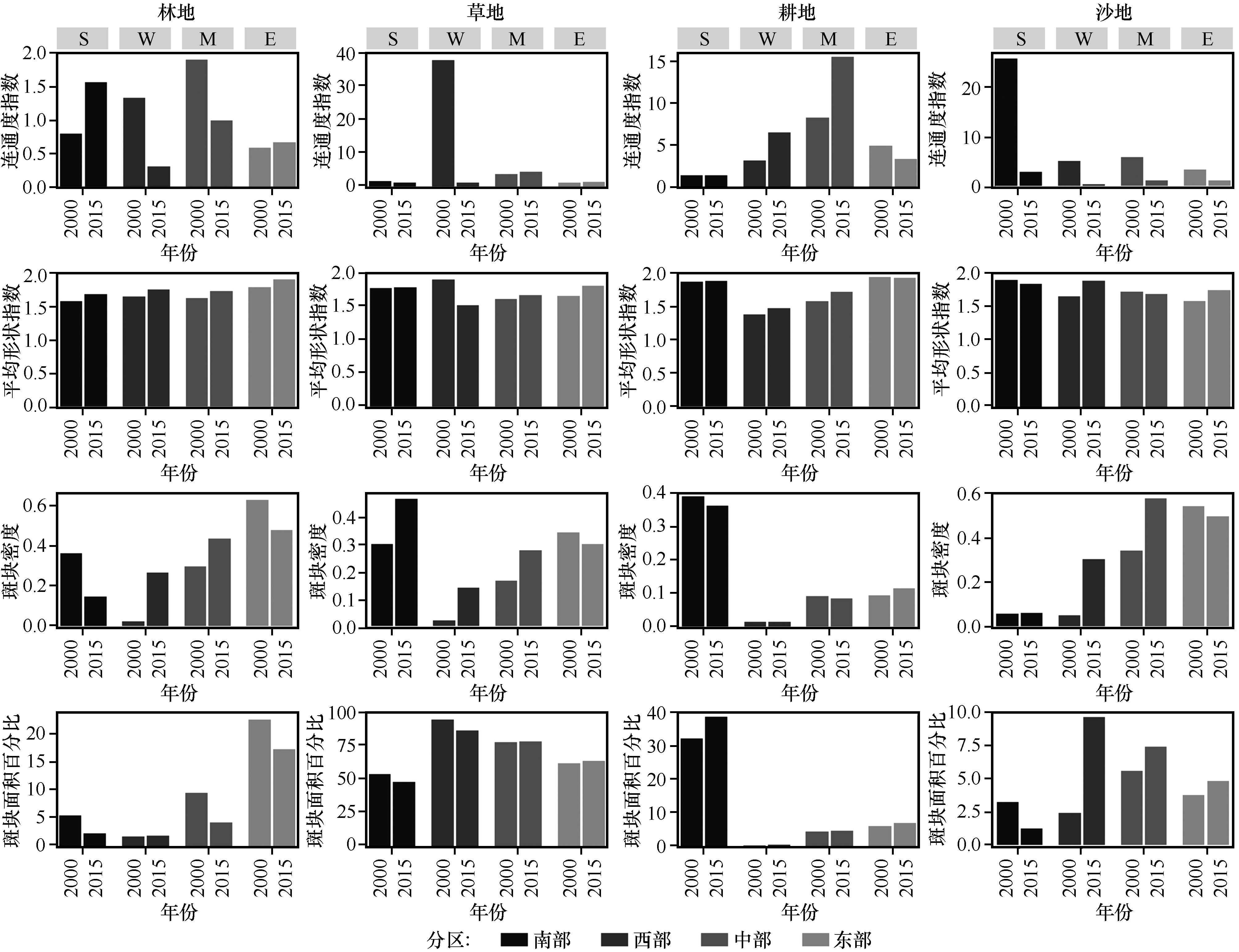
Fig.2 The landscape pattern index and its changes of each spatial unit before and after the sand control in Hunshandake Sandy Land
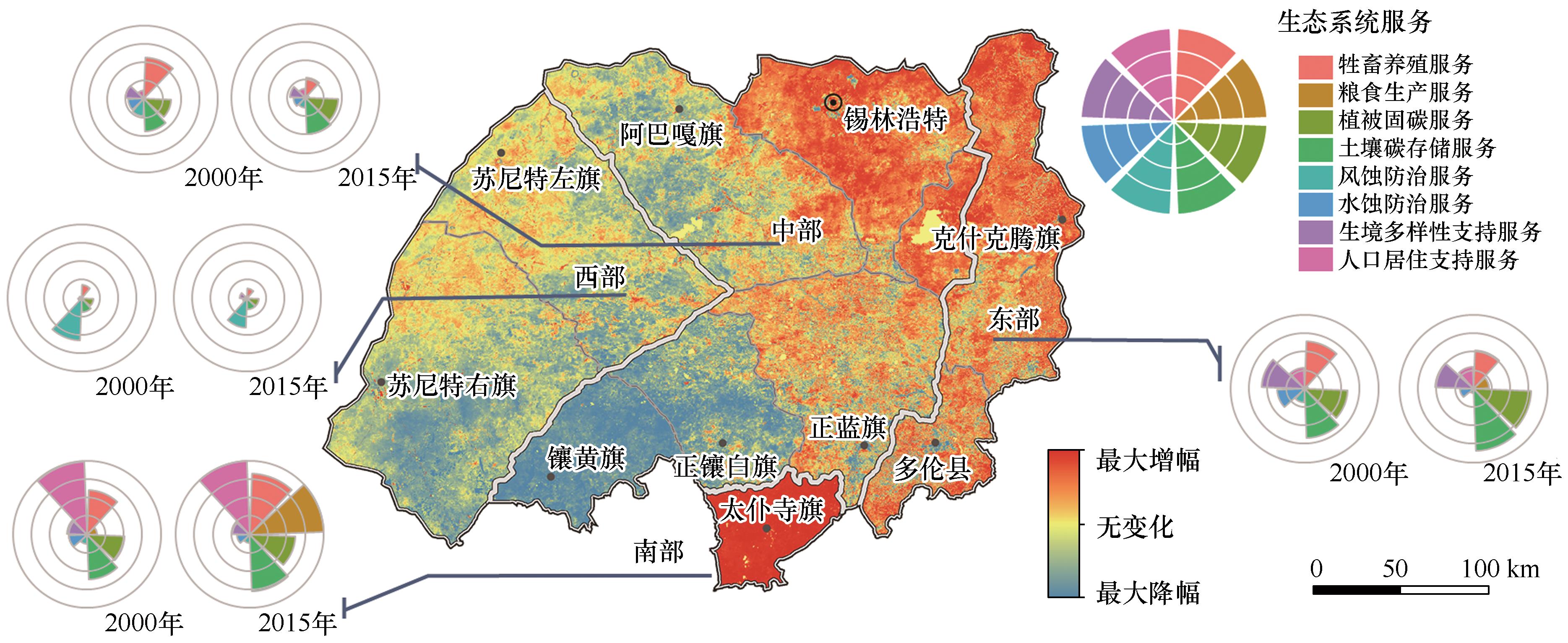
Fig.3 Changes of ecosystem services (ESs) and multiple ecosystem services landscape index (MESLI) in Hunshandake Sandy Land from 2000 to 2015
| 土地利用类型 | 生态系统服务 | |||||||||
|---|---|---|---|---|---|---|---|---|---|---|
| 牲畜养殖服务 | 粮食生产服务 | 植被固碳服务 | 土壤碳存储服务 | 风蚀防治服务 | 水蚀防治服务 | 生境多样性支持服务 | 人口居住支持服务 | |||
| 林地 | 景观组成 | 斑块面积百分比 | 0.160 | 0.026 | 0.585*** | 0.577*** | -0.373*** | 0.340*** | 0.936*** | -0.003 |
| 斑块密度 | 0.101 | 0.049 | 0.498*** | 0.481*** | -0.440*** | 0.236 | 0.784*** | 0.084 | ||
| 景观配置 | 平均形状指数 | 0.069 | 0.097 | 0.304*** | 0.289 | -0.147 | 0.262*** | 0.351*** | -0.038 | |
| 连通度指数 | -0.026 | -0.061 | -0.124 | -0.074 | 0.142 | 0.080 | -0.201 | -0.108 | ||
| 草地 | 景观组成 | 斑块面积百分比 | -0.366*** | -0.518*** | -0.663*** | -0.714*** | 0.584*** | -0.507*** | -0.762*** | -0.606*** |
| 斑块密度 | 0.196 | 0.334*** | 0.566*** | 0.557*** | -0.514*** | 0.305*** | 0.739*** | 0.329*** | ||
| 景观配置 | 平均形状指数 | -0.039 | 0.105 | 0.026 | 0.026 | 0.320*** | 0.016 | -0.063 | 0.098 | |
| CONNECT | -0.274*** | -0.157 | -0.382*** | -0.404*** | 0.624*** | -0.231 | -0.373*** | -0.210 | ||
| 耕地 | 景观组成 | 斑块面积百分比 | 0.364*** | 0.643*** | 0.322*** | 0.415*** | -0.284*** | 0.298*** | 0.140 | 0.818*** |
| 斑块密度 | 0.330*** | 0.520*** | 0.305*** | 0.389*** | -0.285*** | 0.326*** | 0.187 | 0.730*** | ||
| 景观配置 | 平均形状指数 | 0.198 | 0.290*** | 0.582*** | 0.574*** | -0.338*** | 0.284*** | 0.513*** | 0.327*** | |
| 连通度指数 | -0.044 | -0.072 | -0.023 | -0.057 | -0.056 | -0.061 | -0.104 | -0.106 | ||
Table 3 Correlations between landscape pattern indexes and the ecosystem services
| 土地利用类型 | 生态系统服务 | |||||||||
|---|---|---|---|---|---|---|---|---|---|---|
| 牲畜养殖服务 | 粮食生产服务 | 植被固碳服务 | 土壤碳存储服务 | 风蚀防治服务 | 水蚀防治服务 | 生境多样性支持服务 | 人口居住支持服务 | |||
| 林地 | 景观组成 | 斑块面积百分比 | 0.160 | 0.026 | 0.585*** | 0.577*** | -0.373*** | 0.340*** | 0.936*** | -0.003 |
| 斑块密度 | 0.101 | 0.049 | 0.498*** | 0.481*** | -0.440*** | 0.236 | 0.784*** | 0.084 | ||
| 景观配置 | 平均形状指数 | 0.069 | 0.097 | 0.304*** | 0.289 | -0.147 | 0.262*** | 0.351*** | -0.038 | |
| 连通度指数 | -0.026 | -0.061 | -0.124 | -0.074 | 0.142 | 0.080 | -0.201 | -0.108 | ||
| 草地 | 景观组成 | 斑块面积百分比 | -0.366*** | -0.518*** | -0.663*** | -0.714*** | 0.584*** | -0.507*** | -0.762*** | -0.606*** |
| 斑块密度 | 0.196 | 0.334*** | 0.566*** | 0.557*** | -0.514*** | 0.305*** | 0.739*** | 0.329*** | ||
| 景观配置 | 平均形状指数 | -0.039 | 0.105 | 0.026 | 0.026 | 0.320*** | 0.016 | -0.063 | 0.098 | |
| CONNECT | -0.274*** | -0.157 | -0.382*** | -0.404*** | 0.624*** | -0.231 | -0.373*** | -0.210 | ||
| 耕地 | 景观组成 | 斑块面积百分比 | 0.364*** | 0.643*** | 0.322*** | 0.415*** | -0.284*** | 0.298*** | 0.140 | 0.818*** |
| 斑块密度 | 0.330*** | 0.520*** | 0.305*** | 0.389*** | -0.285*** | 0.326*** | 0.187 | 0.730*** | ||
| 景观配置 | 平均形状指数 | 0.198 | 0.290*** | 0.582*** | 0.574*** | -0.338*** | 0.284*** | 0.513*** | 0.327*** | |
| 连通度指数 | -0.044 | -0.072 | -0.023 | -0.057 | -0.056 | -0.061 | -0.104 | -0.106 | ||
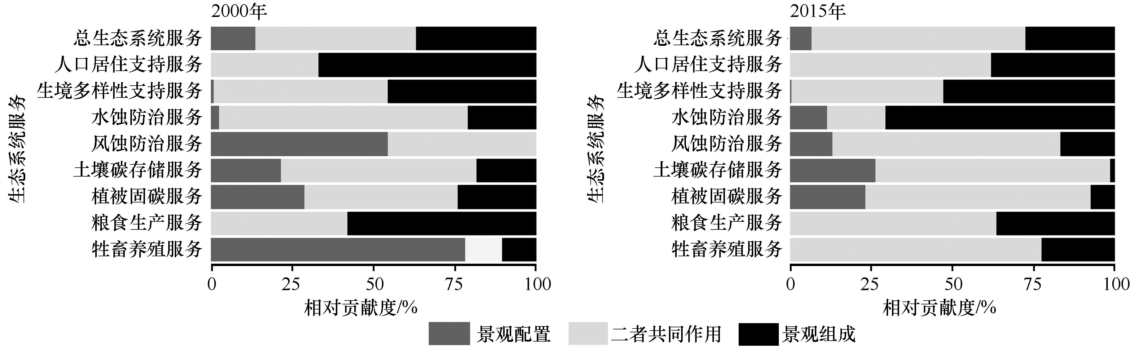
Fig.4 Relative contribution of landscape composition and landscape configuration to the ecosystem services

Fig.5 RDA ordination diagram of the relationship between landscape index and ecosystem service supply
| 1 | 孙建芸.基于遥感技术的浑善达克沙地荒漠化时空特征与动态分析[D].武汉:湖北大学,2017. |
| 2 | 严恩萍,林辉,党永峰,等.2000-2012年京津风沙源治理区植被覆盖时空演变特征[J].生态学报,2014,34(17):5007-5020. |
| 3 | Meng Z J, Dang X H, Gao Y,et al.Interactive effects of wind speed,vegetation coverage and soil moisture in controlling wind erosion in a temperate desert steppe,Inner Mongolia of China[J].Journal of Arid Land,2018,10(4):534-547. |
| 4 | Jiang C, Liu J, Zhang H,et al.China's progress towards sustainable land degradation control:insights from the northwest arid regions[J].Ecological Engineering,2019,127:75-87. |
| 5 | 刘海江,程维明,龙恩.受损沙地生态系统景观变化分析:以内蒙古浑善达克沙地为例[J].植物生态学报,2007,31(6):1063-1072. |
| 6 | 王俊枝,常屹冉,匡文慧,等.浑善达克沙漠化防治重点生态系统功能区防风固沙功能动态特征分析[J].北京师范大学学报(自然科学版),2018,54(3):348-356. |
| 7 | 常虹,翟琇,石磊,等.基于土地利用的内蒙古牧区生态系统服务时空变化(2000-2015)[J].草地学报,2021,29(3):583-592. |
| 8 | 祝萍,刘鑫,郑瑜晗,等.北方重点生态功能区生态系统服务权衡与协同[J].生态学报,2020,40(23):8694-8706. |
| 9 | Tscharntke T, Tylianakis J M, Rand T A,et al.Landscape moderation of biodiversity patterns and processes:eight hypotheses[J].Biological Reviews,2012,87(3):661-685. |
| 10 | Turner M G, Donato D C, Romme W H.Consequences of spatial heterogeneity for ecosystem services in changing forest landscapes:priorities for future research[J].Landscape Ecology,2013,28(6):1081-1097. |
| 11 | Sun X, Lu Z M, Li F,et al.Analyzing spatio-temporal changes and trade-offs to support the supply of multiple ecosystem services in Beijing,China[J].Ecological Indicators,2018,94:117-129. |
| 12 | Wang S, Zhang B, Xie G,et al.Vegetation cover changes and sand-fixing service responses in the Beijing-Tianjin sandstorm source control project area[J].Environmental Development,2020,34:100455. |
| 13 | Allan E, Manning P, Alt F,et al.Land use intensification alters ecosystem multifunctionality via loss of biodiversity and changes to functional composition[J].Ecology Letters,2015,18(8):834-843. |
| 14 | Chillo V, Vázquez D P, Amoroso M M,et al.Land-use intensity indirectly affects ecosystem services mainly through plant functional identity in a temperate forest[J].Functional Ecology,2018,32(5):1390-1399. |
| 15 | Lamy T, Liss K N, Gonzalez A,et al.Landscape structure affects the provision of multiple ecosystem services[J].Environmental Research Letters,2016,11(12):124017. |
| 16 | 吕达仁,陈佐忠,陈家宜,等.内蒙古半干旱草原土壤-植被-大气相互作用(IMGRASS)综合研究[J].地学前缘,2002,9(2):295-306. |
| 17 | 高尚玉,张春来,邹学勇,等.京津风沙源治理工程效益[M].北京:科学出版社,2012:62-74. |
| 18 | 齐丹卉,杨洪晓,卢琦,等.浑善达克沙地植物群落主要类型与特征[J].中国沙漠,2021,41(4):23-33. |
| 19 | 陈永福,顾兆炎,储国强,等.浑善达克沙地近50年来风沙活动的湖泊记录[J].第四纪研究,2009,29(4):774-780. |
| 20 | Liu B Y, Nearing M A, Risse L M.Slope gradient effects on soil loss for steep slopes[J].Transactions of the ASAE,1994,37(6):1835-1840. |
| 21 | 朱文泉,潘耀忠,张锦水.中国陆地植被净初级生产力遥感估算[J].植物生态学报,2007,31(3):413-424. |
| 22 | Kunkel M L, Flores A N, Smith T J,et al.A simplified approach for estimating soil carbon and nitrogen stocks in semi-arid complex terrain[J].Geoderma,2011,165(1):1-11. |
| 23 | Rodríguez-Loinaz G, Alday J G, Onaindia M.Multiple ecosystem services landscape index:a tool for multifunctional landscapes conservation[J].Journal of Environmental Management,2015,147:152-163. |
| 24 | McGarigal K,Cushman S A,Neel M C, et al.FRAGSTATS v4:spatial pattern analysis program for categorical and continuous maps[Z].Amherst, Massachusetts,USA:University of Massachusetts,2012. |
| 25 | Borcard D, Gillet F, Legendre P.Numerical Ecology with R[M].Berlin,Germany:Springe,2012:203-297. |
| 26 | Legendre P, Legendre L.Numerical Ecology[M].Netherlands:Elsevier,2012:629-660. |
| 27 | 赖江山.数量生态学:R语言的应用[M].北京:科学出版社,2014:138-176. |
| 28 | 马永桃,任孝宗,胡慧芳,等.基于地理探测器的浑善达克沙地植被变化定量归因[J].中国沙漠,2021,41(4):195-204. |
| 29 | Batunacun Nendel C, Hu Y F, Lakes T.Land-use change and land degradation on the Mongolian Plateau from 1975 to 2015:a case study from Xilingol,China[J].Land Degradation & Development,2018,29(6):1595-1606. |
| 30 | Jiang P, Chen D M, Xiao J,et al.Climate and anthropogenic influences on the spatiotemporal change in degraded grassland in China[J].Environmental Engineering Science,2021,38(11):1065-1077. |
| 31 | 王旭洋,李玉霖,连杰,等.半干旱典型风沙区植被覆盖度演变与气候变化的关系及其对生态建设的意义[J].中国沙漠,2021,41(1):183-194. |
| 32 | 康文平,刘树林,段翰晨.基于MODIS时间序列数据的沙漠化遥感监测及沙漠化土地图谱分析:以内蒙古中西部地区为例[J].中国沙漠,2016,36(2):307-318. |
| 33 | Chen W, Zhao J, Cao C X,et al.Shrub biomass estimation in semi-arid sandland ecosystem based on remote sensing technology[J].Global Ecology and Conservation,2018,16:e00479. |
| 34 | Mayaud J R, Bailey R M, Wiggs G F.A coupled vegetation/sediment transport model for dryland environments[J].Journal of Geophysical Research:Earth Surface,2017,122(4):875-900. |
| 35 | Cheng H, Zhang K D, Liu C C,et al.Wind tunnel study of airflow recovery on the lee side of single plants[J].Agricultural and Forest Meteorology,2018,263:362-372. |
| 36 | Liu C C, Zheng Z Q, Cheng H,et al.Airflow around single and multiple plants[J].Agricultural and Forest Meteorology,2018,252:27-38. |
| 37 | Moreno-de las Heras M, Saco P M, Willgoose G R,et al.Assessing landscape structure and pattern fragmentation in semiarid ecosystems using patch-size distributions[J].Ecological Applications,2011,21(7):2793-2805. |
| 38 | Okin G S, Heras M M, Saco P M,et al.Connectivity in dryland landscapes:shifting concepts of spatial interactions[J].Frontiers in Ecology and the Environment,2015,13(1):20-27. |
| 39 | Cheng H, He W W, Liu C C,et al.Transition model for airflow fields from single plants to multiple plants[J].Agricultural and Forest Meteorology,2019(266/267):29-42. |
| 40 | Mitchell M G, Suarezcastro A F, Martinezharms M J,et al.Reframing landscape fragmentation's effects on ecosystem services[J].Trends in Ecology & Evolution,2015,30(4):190-198. |
| 41 | Andrieu E, Vialatte A, Sirami C.Misconceptions of fragmentation's effects on ecosystem services:a response to mitchell et al[J].Trends in Ecology & Evolution,2015,30(11):633-634. |
| 42 | Qi L, Zhao F Q, Sun J.An integrated multi-scale approach to restoring a degraded secondary forest ecosystem:a case study in the Changbai Mountains,Northeastern China[J].Ecological Engineering,2018,125:98-105. |
| 43 | Sun Y F, Zhang Y Q, Feng W,et al.Revegetated shrub species recruit different soil fungal assemblages in a desert ecosystem[J].Plant and Soil,2019,435(1):81-93. |
| 44 | Lu F, Hu H F, Sun W J,et al.Effects of national ecological restoration projects on carbon sequestration in China from 2001 to 2010[J].Proceedings of the National Academy of Sciences of the United States of America,2018,115(16):4039-4044. |
| 45 | Fang J Y, Yu G R, Liu L L,et al.Climate change,human impacts,and carbon sequestration in China[J].Proceedings of the National Academy of Sciences of the United States of America,2018,115(16):4015-4020. |
| 46 | Wu J G.Key concepts and research topics in landscape ecology revisited:30 years after the Allerton Park workshop[J].Landscape Ecology,2013,28(1):1-11. |
| 47 | Manning P, van der Plas F, Soliveres S,et al.Redefining ecosystem multifunctionality[J].Nature Ecology and Evolution,2018,2(3):427-436. |
| [1] | Yaowen Zhang, Bo Zhang, Rongpeng Yao, Libing Wang. Temporal and spatial changes of vegetation coverage and water production in the Weihe River Basin from 2000 to 2020 [J]. Journal of Desert Research, 2022, 42(2): 223-233. |
| [2] | Yanhui Lei, Guodong Ding, Zimeng Li, Wenfeng Chi, Guanglei Gao, Yuanyuan Zhao. Land use/cover change and its ecosystem service value response in the Beijing-Tianjin sandstorm source control project area [J]. Journal of Desert Research, 2021, 41(6): 29-40. |
| [3] | Mengtao Han, Jianjun Tu, Guiping Xu, Li Jiang. Spatio-temporal coordination between aquatic ecosystem services and economic development in the Yellow River Basin [J]. Journal of Desert Research, 2021, 41(4): 167-176. |
| [4] | Li Li, Qingqing Zhang, Yamei Wang, Hong Li, Xinfeng Zhao. Comprehensive assessment of ecosystem vulnerability, the value of service function and risk in Kezi River Basin in 2000-2018 [J]. Journal of Desert Research, 2021, 41(2): 164-172. |
| [5] | Yabin Chang, Rui Zhu, Shengchun Xiao, Yapei Li. Sandy land change from 1980 to 2015 in Alxa League, China and its driving factors [J]. Journal of Desert Research, 2020, 40(6): 82-90. |
| [6] | Wang Ying, Zhang Qiang, Wang Jinsong, Zhang Lei. Appling SWAT Model to Explore the Impacts of Land Use and Climate Changes on the Hydrological Characteristics in Taohe River Basin [J]. JOURNAL OF DESERT RESEARCH, 2017, 37(1): 175-185. |
| [7] | Li Hongjian, Ren Zhiyuan, Liu Yanxu, Zhang Jing. Tradeoffs-synergies Analysis among Ecosystem Services in Northwestern Valley Basin: Taking Yinchuan Basin as an Example [J]. JOURNAL OF DESERT RESEARCH, 2016, 36(6): 1731-1738. |
| [8] | Zhao Minmin, Zhou Lihua, Chen Yong, Zhang Jishu, Guo Xiuli, Wang Rui. The Influence of Ecological Policies on Changes of Land Use and Ecosystem Service Value in Hangjinqi, Inner Mongolia, China [J]. JOURNAL OF DESERT RESEARCH, 2016, 36(3): 842-850. |
| [9] | Liu Zhengyao, Dong Zhibao, Wang Jianbo, Dong Ruijie. Practice and Development of Deserticulture in Inner Mongolia, China: a view of ecosystem service system [J]. JOURNAL OF DESERT RESEARCH, 2015, 35(4): 1057-1064. |
| [10] | Wang Jinhua, Dong Yuxiang. Coastal Sandy Land Use Change in South China Coast from 1958 to 2013 and Its Driving Factors-taking Fujian coast as an example [J]. JOURNAL OF DESERT RESEARCH, 2015, 35(3): 582-591. |
| [11] | Tian Xiafei, Xue Xian, Liao Jie, Du Heqiang, Duan Hanchen, Xu Manhou. Land Use Change in the Watershed of the Ningxia-Inner Mongolia Reaches of the Yellow River During 1990-2010 [J]. JOURNAL OF DESERT RESEARCH, 2014, 34(4): 1167-1176. |
| [12] | Zulpiya Mamat, Hamit Yimit, Anwar Eziz, Ajigul Ablimit. Response of Ecosystem Services Value to Land Use/Cover Change in the Yanqi Basin of Xinjiang, China [J]. JOURNAL OF DESERT RESEARCH, 2014, 34(1): 275-283. |
| [13] | BAI Yuan1,2, XU Hai-liang1, LING Hong-bo1,2, FU Jin-yi1,2. Analysis on Land Use Changes and Ecosystem Services Value in the Area along the Tarim River [J]. JOURNAL OF DESERT RESEARCH, 2013, 33(6): 1912-1920. |
| [14] | CHENG Lei-lei, GUO Hao, LU Qi. Review on the Valuation of Desert Ecosystem Service Values [J]. JOURNAL OF DESERT RESEARCH, 2013, 33(1): 281-287. |
| [15] | MA Yi-juan1, HOU Zhi-hua1, XU Xiao-li2. The Impact of Land Use Change on Ecology-Economy Harmony Degree in the upper Reaches of Fenhe River Watershed [J]. JOURNAL OF DESERT RESEARCH, 2012, 32(6): 1803-1808. |
| Viewed | ||||||
|
Full text |
|
|||||
|
Abstract |
|
|||||
©2018Journal of Desert Research
Tel:0931-8267545
Email:caiedit@lzb.ac.cn;desert@lzb.ac.cn
Support:Magtech