
- CN 62-1070/P
- ISSN 1000-694X
- Bimonthly 1981
Journal of Desert Research ›› 2024, Vol. 44 ›› Issue (4): 81-90.DOI: 10.7522/j.issn.1000-694X.2024.00054
Previous Articles Next Articles
Teng Zhang1,2( ), Yunfa Miao1,2(), Yaguo Zou1,2, Ziyue Zhang1,2, Guoping Feng3
Received:2024-03-02
Revised:2024-04-12
Online:2024-07-20
Published:2024-08-29
Contact:
Yunfa Miao
CLC Number:
Teng Zhang, Yunfa Miao, Yaguo Zou, Ziyue Zhang, Guoping Feng. Classification and changes of vegetation in Sugan Lake wetland in the extreme arid region[J]. Journal of Desert Research, 2024, 44(4): 81-90.
Add to citation manager EndNote|Ris|BibTeX
URL: http://www.desert.ac.cn/EN/10.7522/j.issn.1000-694X.2024.00054
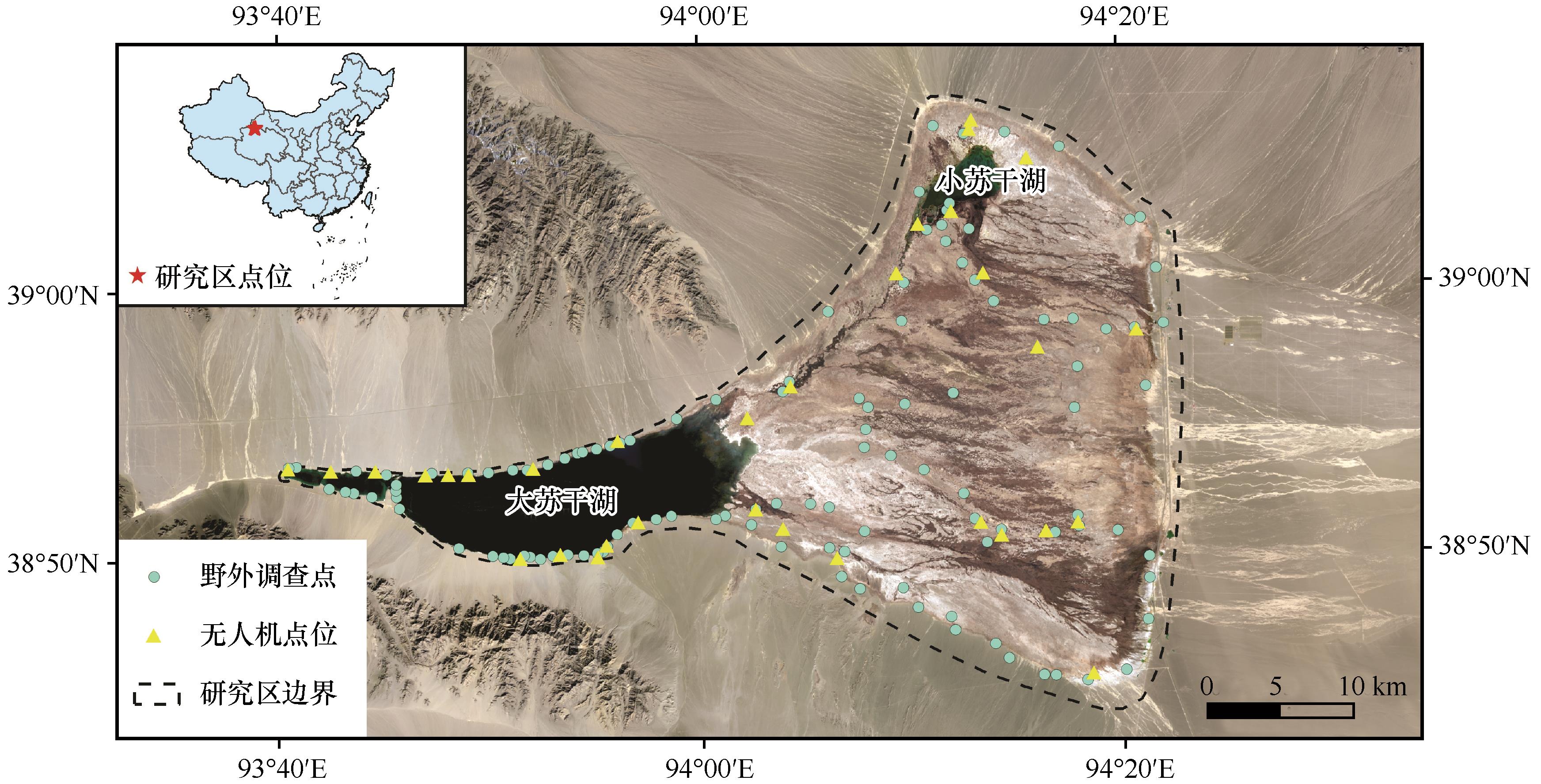
Fig.1 The geographical location of Sugan Lake wetland and the distribution of working points
| 指标 | 植被群落类型 | |||||||
|---|---|---|---|---|---|---|---|---|
| 芦苇 | 赖草 | 水麦冬 | 沼泽荸荠 | 乳苣 | 盐角草 | 心叶独行菜 | 菖蒲 | |
| 样本标签数量 | 186 | 118 | 49 | 100 | 57 | 24 | 40 | 52 |
Table 1 Sample labels for vegetation community classification in Sugan Lake wetland
| 指标 | 植被群落类型 | |||||||
|---|---|---|---|---|---|---|---|---|
| 芦苇 | 赖草 | 水麦冬 | 沼泽荸荠 | 乳苣 | 盐角草 | 心叶独行菜 | 菖蒲 | |
| 样本标签数量 | 186 | 118 | 49 | 100 | 57 | 24 | 40 | 52 |
| 特征指数 | 特征说明 | 数量 | 数据 来源 |
|---|---|---|---|
| 原始波段 | B2、B3、B4、B8、B11、B12 | 6 | MSI |
| 植被水体指数 | NDVI、NDWI、RVI… | 24 | MSI |
| 缨帽指数 | Brightness、Greenness、Wetness | 3 | MSI |
| 红边指数 | Ndvire1、Ndvire2、Ndvire3… | 5 | MSI |
| 纹理特征指数 | Asm、Contrast、Corr… | 9 | MSI |
| SAR时序特征指数 | VH max、VH min、VH mean… | 8 | SAR |
Table 2 Selection of features for vegetation classification based on SAR dataset and MSI dataset
| 特征指数 | 特征说明 | 数量 | 数据 来源 |
|---|---|---|---|
| 原始波段 | B2、B3、B4、B8、B11、B12 | 6 | MSI |
| 植被水体指数 | NDVI、NDWI、RVI… | 24 | MSI |
| 缨帽指数 | Brightness、Greenness、Wetness | 3 | MSI |
| 红边指数 | Ndvire1、Ndvire2、Ndvire3… | 5 | MSI |
| 纹理特征指数 | Asm、Contrast、Corr… | 9 | MSI |
| SAR时序特征指数 | VH max、VH min、VH mean… | 8 | SAR |
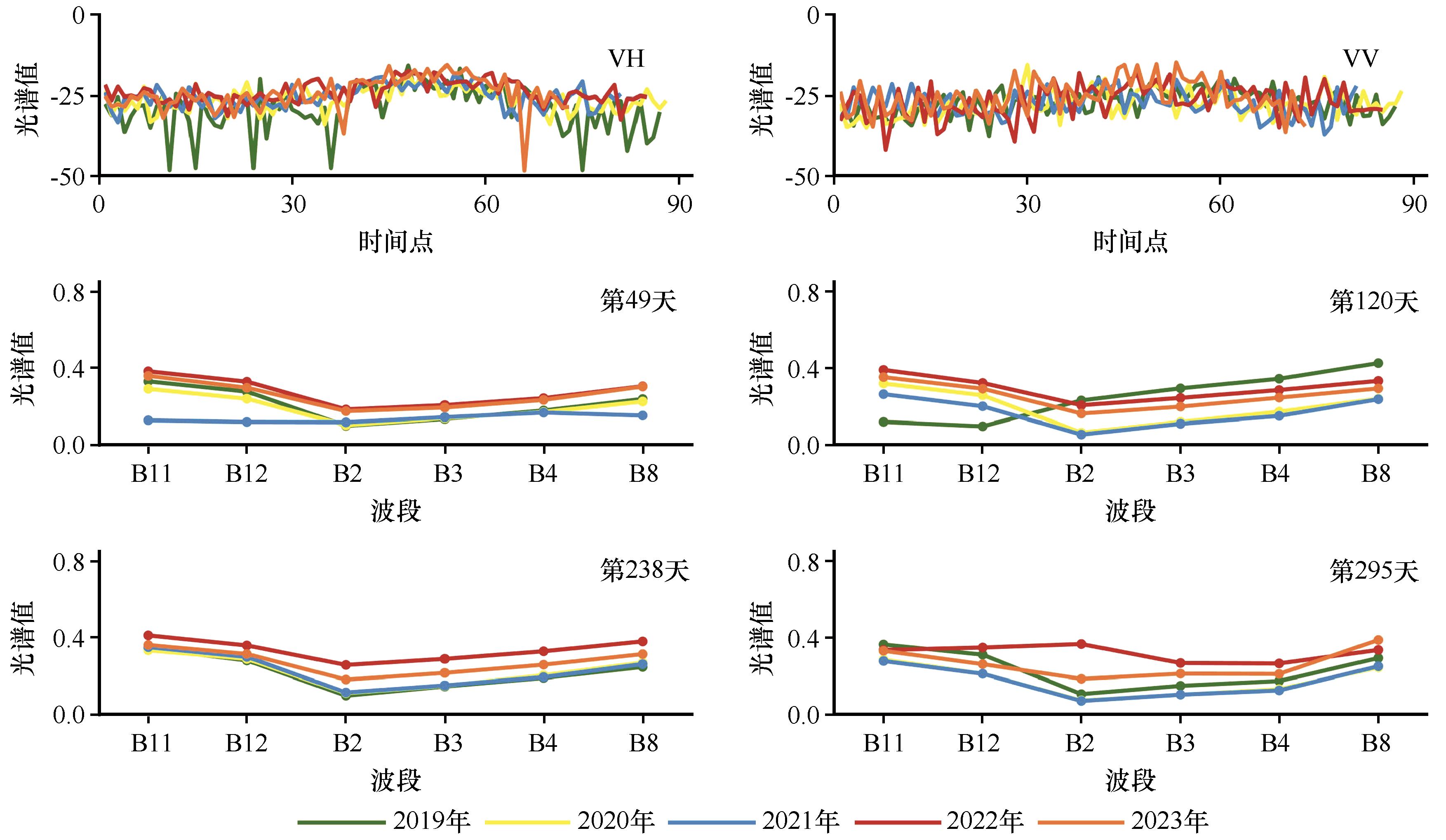
Fig.2 Spectral change characteristics of sample points in Sugan Lake wetland from 2019 to 2023
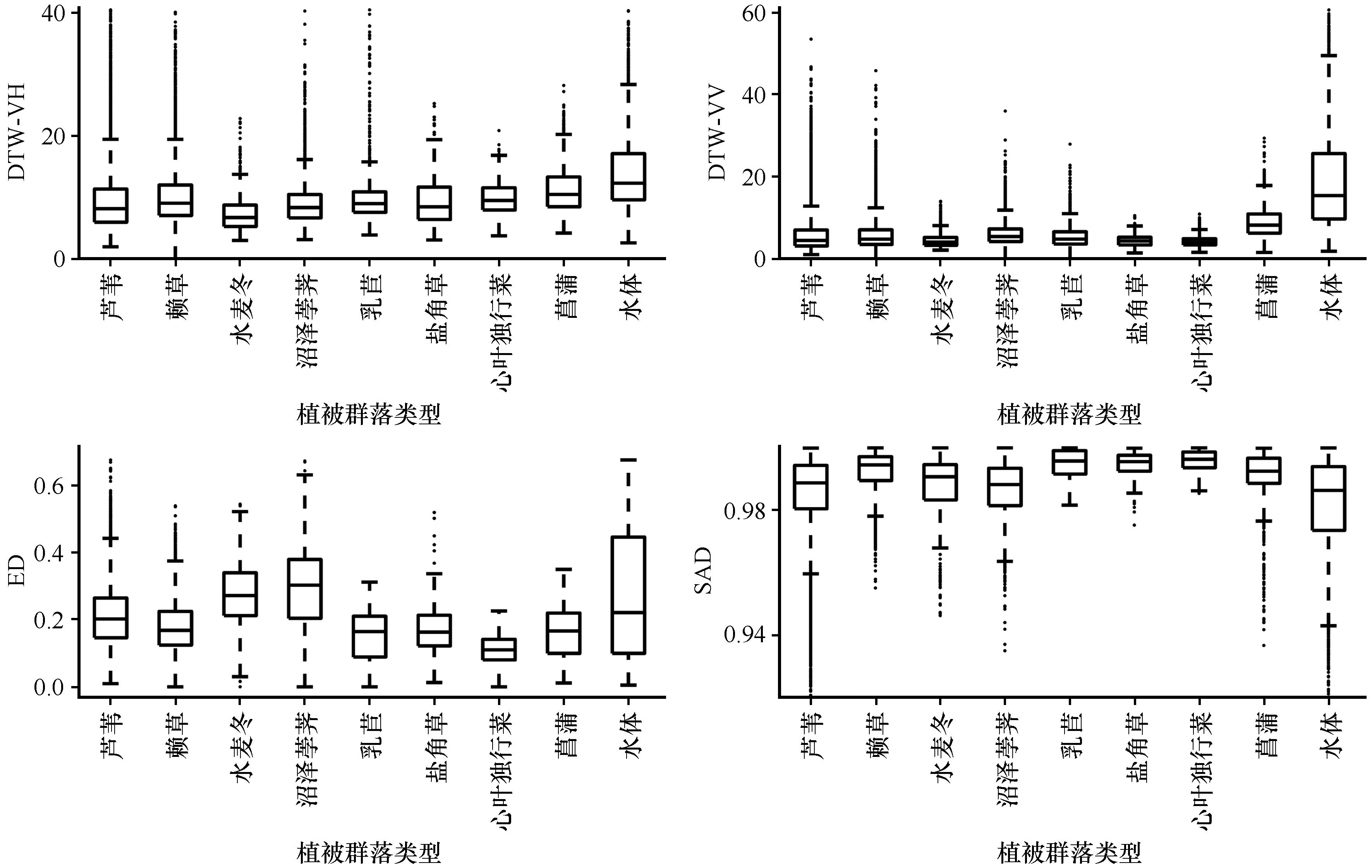
Fig.3 Boxplot of the calculation results for the same type of sample labels in Sugan Lake wetland in 2023
| 指标 | 植被群落类型 | |||||||
|---|---|---|---|---|---|---|---|---|
| 芦苇 | 赖草 | 水麦冬 | 沼泽荸荠 | 乳苣 | 盐角草 | 心叶独行菜 | 菖蒲 | |
| DTW_VH | 19.46 | 19.44 | 13.78 | 16.16 | 15.79 | 19.40 | 16.86 | 20.25 |
| DTW_VV | 12.88 | 12.45 | 8.15 | 7.32 | 6.67 | 5.33 | 4.96 | 10.97 |
| ED | 0.44 | 0.37 | 0.52 | 0.63 | 0.31 | 0.33 | 0.23 | 0.35 |
| SAD | 0.96 | 0.98 | 0.97 | 0.96 | 0.98 | 0.99 | 0.99 | 0.98 |
Table 3 The threshold setting for feature extraction of historical period samples in Suhan Lake wetland
| 指标 | 植被群落类型 | |||||||
|---|---|---|---|---|---|---|---|---|
| 芦苇 | 赖草 | 水麦冬 | 沼泽荸荠 | 乳苣 | 盐角草 | 心叶独行菜 | 菖蒲 | |
| DTW_VH | 19.46 | 19.44 | 13.78 | 16.16 | 15.79 | 19.40 | 16.86 | 20.25 |
| DTW_VV | 12.88 | 12.45 | 8.15 | 7.32 | 6.67 | 5.33 | 4.96 | 10.97 |
| ED | 0.44 | 0.37 | 0.52 | 0.63 | 0.31 | 0.33 | 0.23 | 0.35 |
| SAD | 0.96 | 0.98 | 0.97 | 0.96 | 0.98 | 0.99 | 0.99 | 0.98 |
| 编号 | 特征指数组合 | 总体分类精度 | Kappa系数 |
|---|---|---|---|
| 1 | 原始波段 | 0.79 | 0.75 |
| 2 | 原始波段+植被水体指数 | 0.82 | 0.79 |
| 3 | 原始波段+植被水体指数+纹理特征指数 | 0.83 | 0.80 |
| 4 | 原始波段+植被水体指数+红边指数+缨帽指数 | 0.83 | 0.81 |
| 5 | 原始波段+植被水体指数+红边指数+纹理特征指数+缨帽指数 | 0.84 | 0.82 |
| 6 | 原始波段+植被水体指数+红边指数+纹理特征指数+缨帽指数+SAR时序特征指数 | 0.85 | 0.82 |
Table 4 Evaluation of vegetation community classification accuracy for different features combinations in Sugan Lake wetland in 2023
| 编号 | 特征指数组合 | 总体分类精度 | Kappa系数 |
|---|---|---|---|
| 1 | 原始波段 | 0.79 | 0.75 |
| 2 | 原始波段+植被水体指数 | 0.82 | 0.79 |
| 3 | 原始波段+植被水体指数+纹理特征指数 | 0.83 | 0.80 |
| 4 | 原始波段+植被水体指数+红边指数+缨帽指数 | 0.83 | 0.81 |
| 5 | 原始波段+植被水体指数+红边指数+纹理特征指数+缨帽指数 | 0.84 | 0.82 |
| 6 | 原始波段+植被水体指数+红边指数+纹理特征指数+缨帽指数+SAR时序特征指数 | 0.85 | 0.82 |
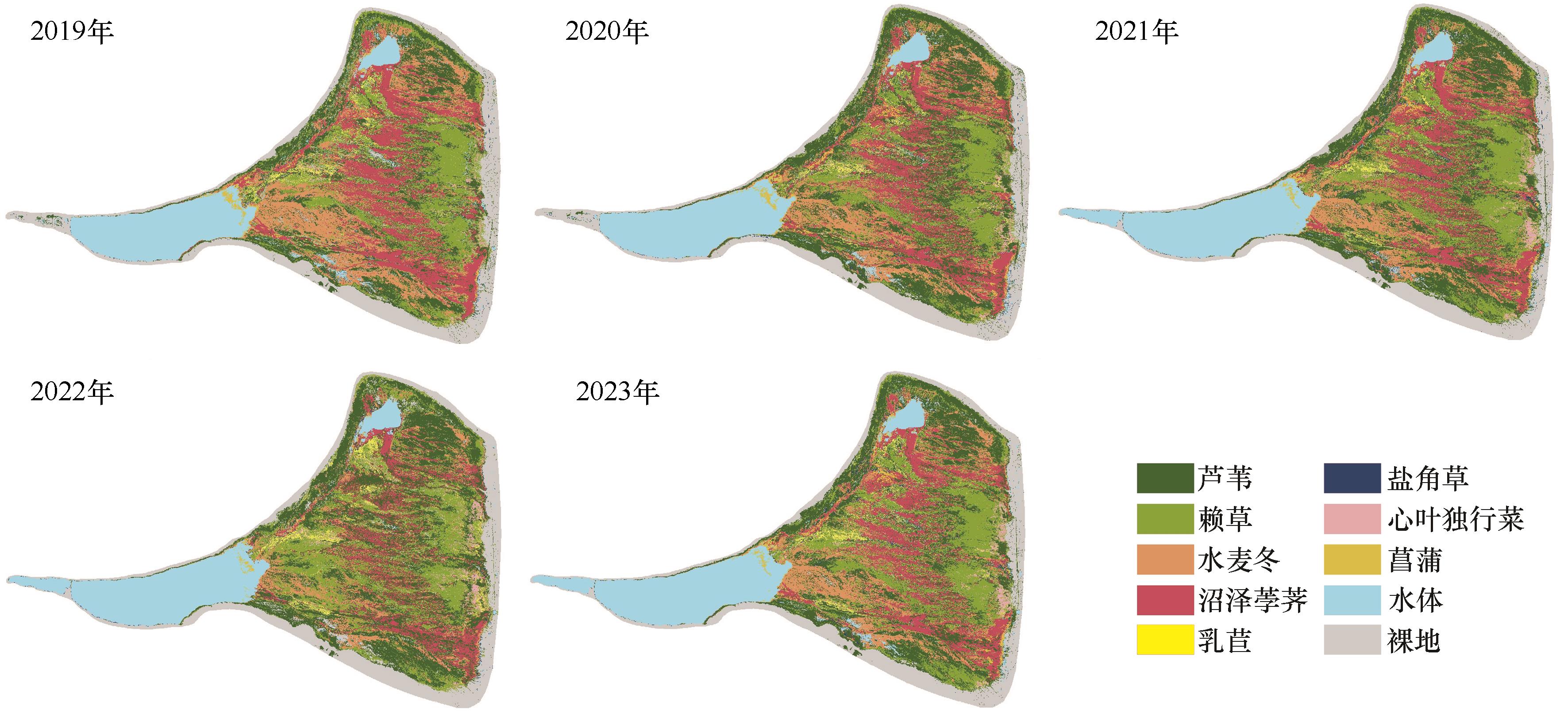
Fig.4 Classification results of vegetation community in Sugan Lake wetland from 2019 to 2023
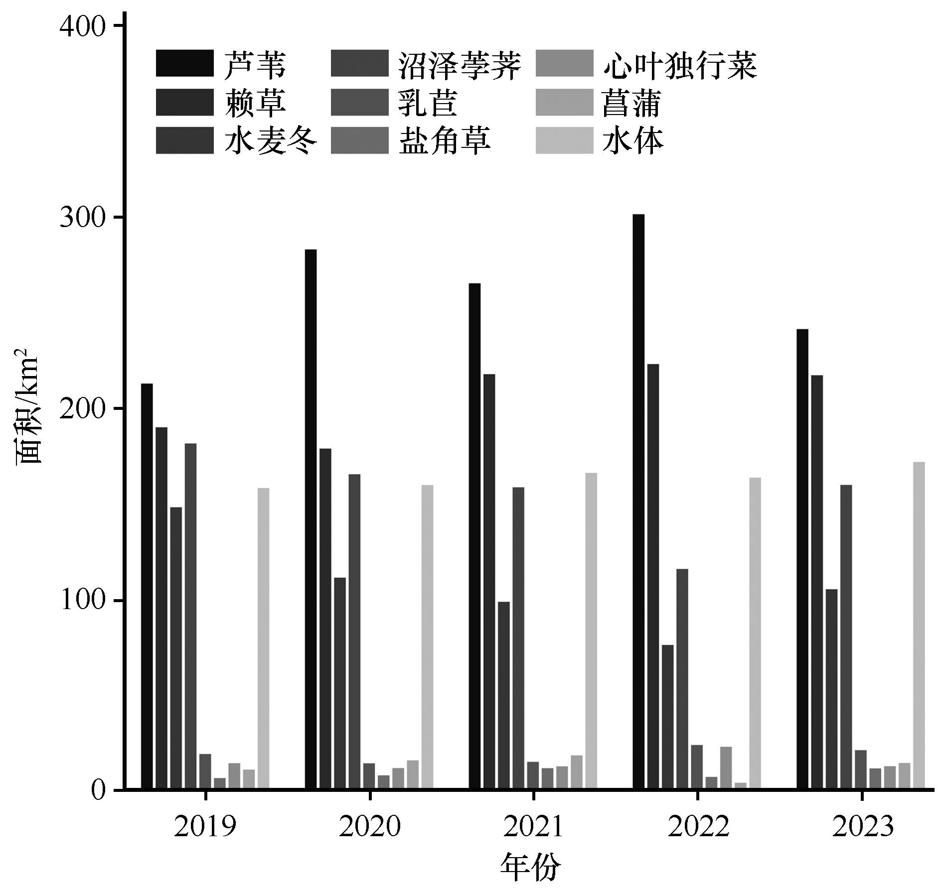
Fig.5 Changes in the vegetation community area in Sugan Lake wetland from 2019 to 2023
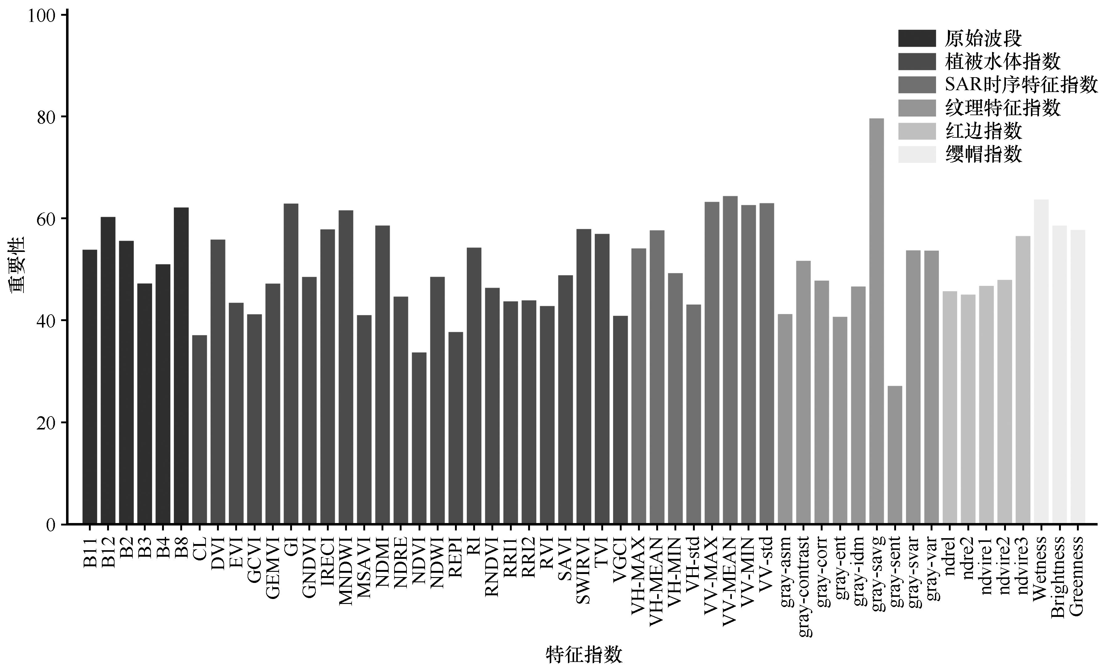
Fig.6 The importance ranking of vegetation classification features in Sugan Lake wetland
| 1 | Levandowski M L, Litt A R, McKenna M F,et al.Multi-method biodiversity assessments from wetlands in Grand Teton National Park[J].Ecological Indicators,2021,131:108205. |
| 2 | Zhang Y, Huang D, Jin X,et al.Long-term wetland biomonitoring highlights the differential impact of land use on macroinvertebrate diversity in Dongting Lake in China[J].Communications Earth & Environment,2024,5(1):32. |
| 3 | Eid A N M, Olatubara C O, Ewemoje T A,et al.Coastal wetland vegetation features and digital change detection mapping based on remotely sensed imagery:El-Burullus Lake,Egypt[J].International Soil and Water Conservation Research,2020,8(1):66-79. |
| 4 | Norman L M, Lal R, Wohl E,et al.Natural infrastructure in dryland streams (NIDS) can establish regenerative wetland sinks that reverse desertification and strengthen climate resilience[J].Science of The Total Environment,2022,849:157738. |
| 5 | Wang Y, Wang H, He J S,et al.Iron-mediated soil carbon response to water-table decline in an alpine wetland[J].Nature Communications,2017,8:15972. |
| 6 | Zhu X, Jiao L, Wu X,et al.Ecosystem health assessment and comparison of natural and constructed wetlands in the arid zone of northwest China[J].Ecological Indicators,2023,154:110576. |
| 7 | Fluet-Chouinard E, Stocker B D, Zhang Z,et al.Extensive global wetland loss over the past three centuries[J].Nature,2023,614(7947):281-286. |
| 8 | 万洪秀,孙占东,王润.博斯腾湖湿地生态脆弱性评价研究[J].干旱区地理,2006(2):248-254. |
| 9 | 徐贺年,王江林,彭小梅,等.青藏高原东北部祁连圆柏径向生长对不同类型干旱的响应[J].应用生态学报,2022,33:2097-2104. |
| 10 | Li C, Fu B, Wang S,et al.Drivers and impacts of changes in China's drylands[J].Nature Reviews Earth & Environment,2021,2(12):858-873. |
| 11 | Guo M, Li J, Sheng C,et al.A Review of Wetland Remote Sensing[J].Sensors (Basel),2017,17(4):777. |
| 12 | 郝斌飞,韩旭军,马明国,等.Google Earth Engine在地球科学与环境科学中的应用研究进展[J].遥感技术与应用,2018,33(4):600-611. |
| 13 | 芦瑞杰,刘树林,康文平,等.结合GEE平台与机器学习算法的荒漠信息提取[J].中国沙漠,2023,43(6):60-70. |
| 14 | 李森,颜长珍.基于ChinaCover数据集的绿洲结构数据制图:以河西内陆河流域为例[J].中国沙漠,2023,43(3):230-242. |
| 15 | Li Y, Hou Z, Zhang L,et al.Long-term spatio-temporal changes of wetlands in Tibetan Plateau and their response to climate change[J].International Journal of Applied Earth Observation and Geoinformation,2023,121:103351. |
| 16 | Geant C B, Gustave M N, Schmitz S.Mapping small inland wetlands in the South-Kivu province by integrating optical and SAR data with statistical models for accurate distribution assessment[J].Scientific Reports,2023,13(1):17626. |
| 17 | 姚杰鹏,杨磊库,陈探,等.基于Sentinel-1,2和Landsat 8时序影像的鄱阳湖湿地连续变化监测研究[J].遥感技术与应用,2021,36(4):760-776. |
| 18 | Chen J, Zhang Z.An improved fusion of Landsat-7/8,Sentinel-2,and Sentinel-1 data for monitoring alfalfa:implications for crop remote sensing[J].International Journal of Applied Earth Observation and Geoinformation,2023,124:103533. |
| 19 | Blickensdörfer L, Oehmichen K, Pflugmacher D,et al.National tree species mapping using Sentinel-1/2 time series and German National Forest Inventory data[J].Remote Sensing of Environment,2024,304:114069. |
| 20 | 程天亮,王新平,马雄忠,等.基于无人机影像的阿拉善东南部荒漠灌丛植被空间格局研究[J].生态学报,2022,42(16):6778-6789. |
| 21 | 江维薇,李文涛,肖衡林.澜沧江流域糯扎渡水库消落带植被的物种组成、空间分布特征及地形解释[J].湖泊科学,2022,34(6):2025-2039. |
| 22 | Huang H, Wang J, Liu C,et al.The migration of training samples towards dynamic global land cover mapping[J].ISPRS Journal of Photogrammetry and Remote Sensing,2020,161:27-36. |
| 23 | 赵夏纬.苏干湖盆地湿地植被时空分布特征及其成因分析[D].兰州:西北师范大学,2021. |
| 24 | Keogh E, Ratanamahatana C A.Exact indexing of dynamic time warping[J].Knowledge and Information Systems,2005,7(3):358-386. |
| 25 | Ji L, Geng X, Sun K,et al.Target detection method for water mapping using Landsat 8 OLI/TIRS Imagery[J].Water,2015,7(12):794-817. |
| 26 | 王奕森,夏树涛.集成学习之随机森林算法综述[J].信息通信技术,2018,12(1):49-55. |
| 27 | 明義森,刘启航,柏荷,等.利用光学和SAR遥感数据的若尔盖湿地植被分类与变化监测[J].遥感学报,2023,27(6):1414-1425. |
| 28 | Balling J, Herold M, Reiche J.How textural features can improve SAR-based tropical forest disturbance mapping[J].International Journal of Applied Earth Observation and Geoinformation,2023,124:103492. |
| 29 | Qian H, Bao N, Meng D,et al.Mapping and classification of Liao River Delta coastal wetland based on time series and multi-source GaoFen images using stacking ensemble model[J].Ecological Informatics,2024,80:102488. |
| 30 | Peng K, Jiang W, Hou P,et al.Continental-scale wetland mapping:a novel algorithm for detailed wetland types classification based on time series Sentinel-1/2 images[J].Ecological Indicators,2023,148:110113. |
| 31 | Nedkov R.Orthogonal transformation of segmented images from the satellite Sentinel-2[J].Comptes rendus de l'Academie bulgare des Sciences,2017,70(5):687-692. |
| 32 | Dong T, Liu J, Shang J,et al.Assessment of red-edge vegetation indices for crop leaf area index estimation[J].Remote Sensing of Environment,2019,222:133-143. |
| 33 | Shen X, Shen M, Wu C,et al.Critical role of water conditions in the responses of autumn phenology of marsh wetlands to climate change on the Tibetan Plateau[J].Global Change Biology,2024,30(1):e17097. |
| 34 | 康满萍,赵成章,白雪,等.苏干湖湿地植被覆盖度时空变化格局[J].生态学报,2020,40(9):2975-2984. |
| 35 | 李平平,王晓丹,陈海龙.苏干湖湿地与奎屯诺尔湿地之间水力联系研究[J].干旱区研究,2022,39(2):429-435. |
| 36 | 王德旺,何萍,张馨予,等.苏干湖流域冰川、湿地对气候变化的响应研究[J].干旱区资源与环境,2023,37(8):107-116. |
| 37 | Yang Y, Wu J, Miao Y,et al.Lake changes during the past five decades in Central East Asia:links with climate change and climate future forecasting[J].Water,2022,14(22):3661. |
| 38 | 康满萍,赵成章,李群.苏干湖湿地土壤全盐含量特征及其与地下水的关联[J].生态学报,2022,42(22):9026-9034. |
| 39 | Zhang M, Delgado-Baquerizo M, Li G,et al.Experimental impacts of grazing on grassland biodiversity and function are explained by aridity[J].Nature Communications,2023,14(1):5040. |
| 40 | 施雅风,沈永平,胡汝骥.西北气候由暖干向暖湿转型的信号、影响和前景初步探讨[J].冰川冻土,2002,24(3):219-226. |
| 41 | 陈发虎,谢亭亭,杨钰杰,等.我国西北干旱区“暖湿化”问题及其未来趋势讨论[J].中国科学:地球科学,2023,53(6):1246-1262. |
| [1] | Ruibing Duan, Rui Zhang, Lele Wang, Yaxin Zhang, Zhan Yang, Xue Dong, Yingbin Ma. Relationship between leaf PV curve water parameters and anatomical characteristics of ten plants spieces in the Ulan Buh Desert [J]. Journal of Desert Research, 2024, 44(5): 205-216. |
| [2] | Jiannan Lu, Yuqiang Li, Xueyong Zhao, Baocheng Li, Xuyang Wang, Rui Zhang. Characteristics of ecological environment changes and advices for combating desertification in typical semi-arid sandy land [J]. Journal of Desert Research, 2024, 44(4): 284-292. |
| [3] | Yuxi Wei, Lijuan Chen, Qi Feng, Haiyang Xi, Rui Guo, Chengqi Zhang. Progress on microbial characteristics in arid salt-affected soils and related factors [J]. Journal of Desert Research, 2024, 44(3): 18-30. |
| [4] | Changxiang Pan, Qianru Ouyang, Mengyu Liao, Yu Fan, Qun Guo, Zhishan Zhang, Genan Wu, Yang Zhao, Lichao Liu, Yanxia Pan, Xinrong Li, Jianjun Qu, Songlin Mu, Shenggong Li. The applicability of ecological restoration technologies and sand industries to the deserted land in northwest arid region of China [J]. Journal of Desert Research, 2023, 43(5): 155-165. |
| [5] | Shanling Cheng, Haipeng Yu, Yu Ren, Jie Zhou, Hongyu Luo, Chenxi Liu, Yongqi Gong. Research progress on the influence mechanism of climate anomalies in arid and semi-arid regions in China [J]. Journal of Desert Research, 2023, 43(3): 21-35. |
| [6] | Lin Li, Hu Liu, Chengpeng Sun, Wenzhi Zhao. Groundwater evapotranspiration estimation based on soil moisture and water table measurements [J]. Journal of Desert Research, 2022, 42(6): 277-287. |
| [7] | Yanbin Hu, Qiang Zhang, Guoju Xiao, Zhengji Qiu, Yongping Li, Zhanqiang Guo. Effect of soil carbon, nitrgen and phosphate contents on maize production in semi-arid regions of China [J]. Journal of Desert Research, 2022, 42(3): 261-273. |
| [8] | Tianyan Su, Zihan Liu, Anqi Cong, Wei Mao, Qiu Yang. Effects of groundwater depth on soil enzymatic activities of typical plant communities in semi-arid area [J]. Journal of Desert Research, 2021, 41(4): 185-194. |
| [9] | Hei Weigao, Zhan Jin, Han Dan, Yang Hongling, Li Yulin. Compatible Biomass Models for Two Dominant Sand-fixing Shrubs in Horqin Sandy Land [J]. Journal of Desert Research, 2019, 39(5): 193-199. |
| [10] | Yang Ke, Meng Yaxiong, Ma Xiaole, Li Baochun, Si Erjing, Wang Juncheng, Ren Panrong, Wang Huajun. Analysis of Relationship between Variations Characteristics of Main Agronomic Traits and Quality in Hops [J]. Journal of Desert Research, 2018, 38(4): 772-779. |
| [11] | Wan Wei, Yan Changzhen, Xiao Shengchun, Xie Jiali, Qian Dawen. Process, Spatial Pattern and Driving Mechanisms of the Aeolian Desertification in the Alxa Plateau from 1975 to 2015 [J]. JOURNAL OF DESERT RESEARCH, 2018, 38(1): 17-29. |
| [12] | Wang Tingting, Feng Qi, Wen Xiaohu, Guo Xiaoyan. Numerical Simulation of Evaporation of Arid Region Based on Extreme Learning Machine [J]. JOURNAL OF DESERT RESEARCH, 2017, 37(6): 1219-1226. |
| [13] | Song Jie, Chunxi, Bai Xuemei, Siqin·Bilige. Review of Grain Size Analysis in China Desert [J]. JOURNAL OF DESERT RESEARCH, 2016, 36(3): 597-603. |
| [14] | Kang Wenping, Liu Shulin, Duan Hanchen. Monitoring and Spatial-temporal Changes Analysis of AeolianDesertified Lands Based on MODIS Data: A case study on the middle-west part of Inner Mongolia, China [J]. JOURNAL OF DESERT RESEARCH, 2016, 36(2): 307-318. |
| [15] | Liang Xiaoyan, Wang Naiang, Li Zhuolun, Chang Peijing, Jia Peng, Niu Zhenmin. Climate Change around the Tengger Desert in 1960-2012 [J]. JOURNAL OF DESERT RESEARCH, 2016, 36(2): 474-482. |
| Viewed | ||||||
|
Full text |
|
|||||
|
Abstract |
|
|||||
©2018Journal of Desert Research
Tel:0931-8267545
Email:caiedit@lzb.ac.cn;desert@lzb.ac.cn
Support:Magtech