
- CN 62-1070/P
- ISSN 1000-694X
- Bimonthly 1981
Journal of Desert Research ›› 2022, Vol. 42 ›› Issue (3): 118-126.DOI: 10.7522/j.issn.1000-694X.2021.00141
Shuo Qiao( ), Haibing Wang(), Hejun Zuo, Xiya Liu, Yueru Wu
Received:2021-08-30
Revised:2022-01-13
Online:2022-05-20
Published:2022-06-01
Contact:
Haibing Wang
CLC Number:
Shuo Qiao, Haibing Wang, Hejun Zuo, Xiya Liu, Yueru Wu. Evolution of ecological service value and network pattern of Mu Us Sandy Land[J]. Journal of Desert Research, 2022, 42(3): 118-126.
Add to citation manager EndNote|Ris|BibTeX
URL: http://www.desert.ac.cn/EN/10.7522/j.issn.1000-694X.2021.00141
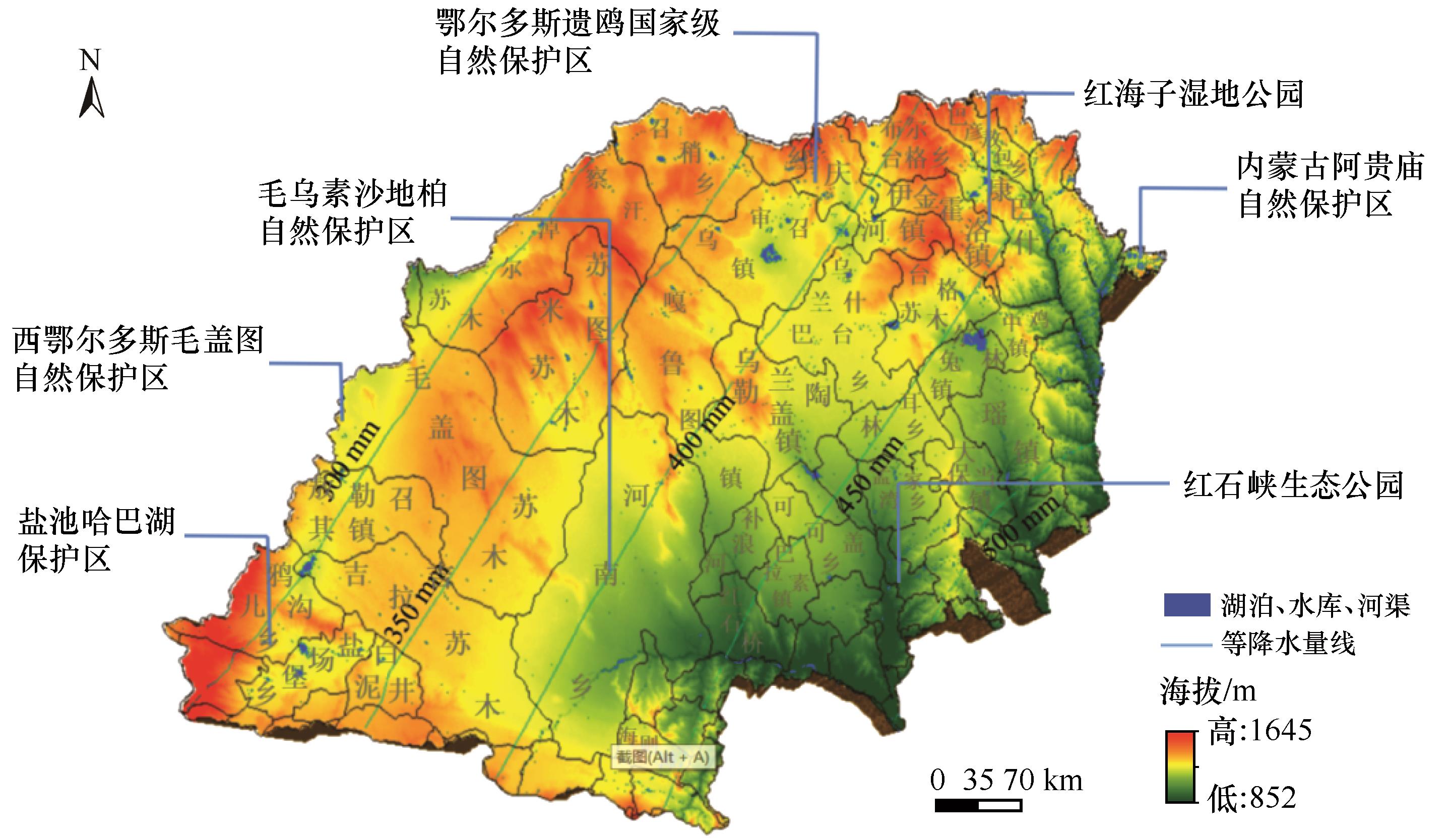
Fig.1 Distribution map of important ecological sources in Mu Us Sandy Land
| 卫星 | 日期(月-日) | 行号 | 列号 | 波段数 | 云量/% | 分辨率 |
|---|---|---|---|---|---|---|
| Landsat 5 TM | 07-31、08-02、08-09 | 127、128、129 | 032、033、034 | 7 | 0、0.10、3.45、9.80 | 30 m×30 m |
| Landsat 7 ETM | 08-28、09-13 | 8 | 0、0.05 | 30 m×30 m | ||
| Landsat 8 OLI/TIRS | 06-03、06-12、06-20、07-05 | 11 | 0、0.05 | 30 m×30 m |
Table 1 Remote sensing image information
| 卫星 | 日期(月-日) | 行号 | 列号 | 波段数 | 云量/% | 分辨率 |
|---|---|---|---|---|---|---|
| Landsat 5 TM | 07-31、08-02、08-09 | 127、128、129 | 032、033、034 | 7 | 0、0.10、3.45、9.80 | 30 m×30 m |
| Landsat 7 ETM | 08-28、09-13 | 8 | 0、0.05 | 30 m×30 m | ||
| Landsat 8 OLI/TIRS | 06-03、06-12、06-20、07-05 | 11 | 0、0.05 | 30 m×30 m |
| 阻力因子 | 等级 | 相对阻力值 | 权重 |
|---|---|---|---|
| 景观类型 | 建设用地 | 200 | 0.4 |
| 耕地、水域 | 50 | ||
| 草地 | 30 | ||
| 未利用地 | 10 | ||
| 园地、林地 | 5 | ||
| 高程/m | 1 950—2 160 | 200 | 0.1 |
| 1 700—1 950 | 50 | ||
| 1 500—1 700 | 30 | ||
| 1 240—1 500 | 10 | ||
| 1 009—1 240 | 5 | ||
| 坡度 | >35 | 200 | 0.1 |
| 25—35 | 50 | ||
| 15—25 | 30 | ||
| 5—15 | 10 | ||
| 0—5 | 5 | ||
| 荒漠化程度 | 极重度 | 200 | 0.2 |
| 重度 | 50 | ||
| 中度 | 30 | ||
| 轻度 | 10 | ||
| 非荒漠 | 5 | ||
| NDVI | 0.80—1.00 | 200 | 0.2 |
| 0.60—0.80 | 50 | ||
| 0.40—0.60 | 30 | ||
| 0.20—0.40 | 10 | ||
| 0—0.20 | 5 |
Table 2 Ecological resistance assignment matrix
| 阻力因子 | 等级 | 相对阻力值 | 权重 |
|---|---|---|---|
| 景观类型 | 建设用地 | 200 | 0.4 |
| 耕地、水域 | 50 | ||
| 草地 | 30 | ||
| 未利用地 | 10 | ||
| 园地、林地 | 5 | ||
| 高程/m | 1 950—2 160 | 200 | 0.1 |
| 1 700—1 950 | 50 | ||
| 1 500—1 700 | 30 | ||
| 1 240—1 500 | 10 | ||
| 1 009—1 240 | 5 | ||
| 坡度 | >35 | 200 | 0.1 |
| 25—35 | 50 | ||
| 15—25 | 30 | ||
| 5—15 | 10 | ||
| 0—5 | 5 | ||
| 荒漠化程度 | 极重度 | 200 | 0.2 |
| 重度 | 50 | ||
| 中度 | 30 | ||
| 轻度 | 10 | ||
| 非荒漠 | 5 | ||
| NDVI | 0.80—1.00 | 200 | 0.2 |
| 0.60—0.80 | 50 | ||
| 0.40—0.60 | 30 | ||
| 0.20—0.40 | 10 | ||
| 0—0.20 | 5 |
| 土地利用 类型 | 年份 | |||||||
|---|---|---|---|---|---|---|---|---|
| 1986 | 1991 | 1996 | 2001 | 2006 | 2011 | 2016 | 2020 | |
| 沙地 | 21 091.81 | 19 910.52 | 19 302.71 | 18 972.44 | 18 044.19 | 16 258.12 | 13 939.57 | 10 196.08 |
| 水域 | 1 347.34 | 1 153.83 | 1 117.15 | 1 075.92 | 1 103.31 | 955.8 | 920.71 | 890.38 |
| 林地 | 16 919.22 | 17 916.41 | 18 409.69 | 18 970.15 | 19 182.74 | 22 368.81 | 23 587.36 | 26 630.85 |
| 耕地 | 894.63 | 1 008.04 | 1 108.04 | 1 117.15 | 1 691.35 | 1 601.04 | 2 147.61 | 2 994.52 |
| 草地 | 4 262.88 | 4 932.29 | 5 131.86 | 5 373.43 | 5 534.24 | 4 934.25 | 5 482.68 | 4 857.55 |
| 建设用地 | 820.61 | 961.80 | 1 020.26 | 1 168.44 | 1 223.25 | 1 321.73 | 1 551.62 | 2 216.76 |
| 其他 | 2 971.24 | 2 424.84 | 2 218.02 | 1 630.20 | 1 528.65 | 867.98 | 964.28 | 521.59 |
Table 3 Variation characteristics of different land use areas in Mu Us Sandy Land during 1986-2020
| 土地利用 类型 | 年份 | |||||||
|---|---|---|---|---|---|---|---|---|
| 1986 | 1991 | 1996 | 2001 | 2006 | 2011 | 2016 | 2020 | |
| 沙地 | 21 091.81 | 19 910.52 | 19 302.71 | 18 972.44 | 18 044.19 | 16 258.12 | 13 939.57 | 10 196.08 |
| 水域 | 1 347.34 | 1 153.83 | 1 117.15 | 1 075.92 | 1 103.31 | 955.8 | 920.71 | 890.38 |
| 林地 | 16 919.22 | 17 916.41 | 18 409.69 | 18 970.15 | 19 182.74 | 22 368.81 | 23 587.36 | 26 630.85 |
| 耕地 | 894.63 | 1 008.04 | 1 108.04 | 1 117.15 | 1 691.35 | 1 601.04 | 2 147.61 | 2 994.52 |
| 草地 | 4 262.88 | 4 932.29 | 5 131.86 | 5 373.43 | 5 534.24 | 4 934.25 | 5 482.68 | 4 857.55 |
| 建设用地 | 820.61 | 961.80 | 1 020.26 | 1 168.44 | 1 223.25 | 1 321.73 | 1 551.62 | 2 216.76 |
| 其他 | 2 971.24 | 2 424.84 | 2 218.02 | 1 630.20 | 1 528.65 | 867.98 | 964.28 | 521.59 |
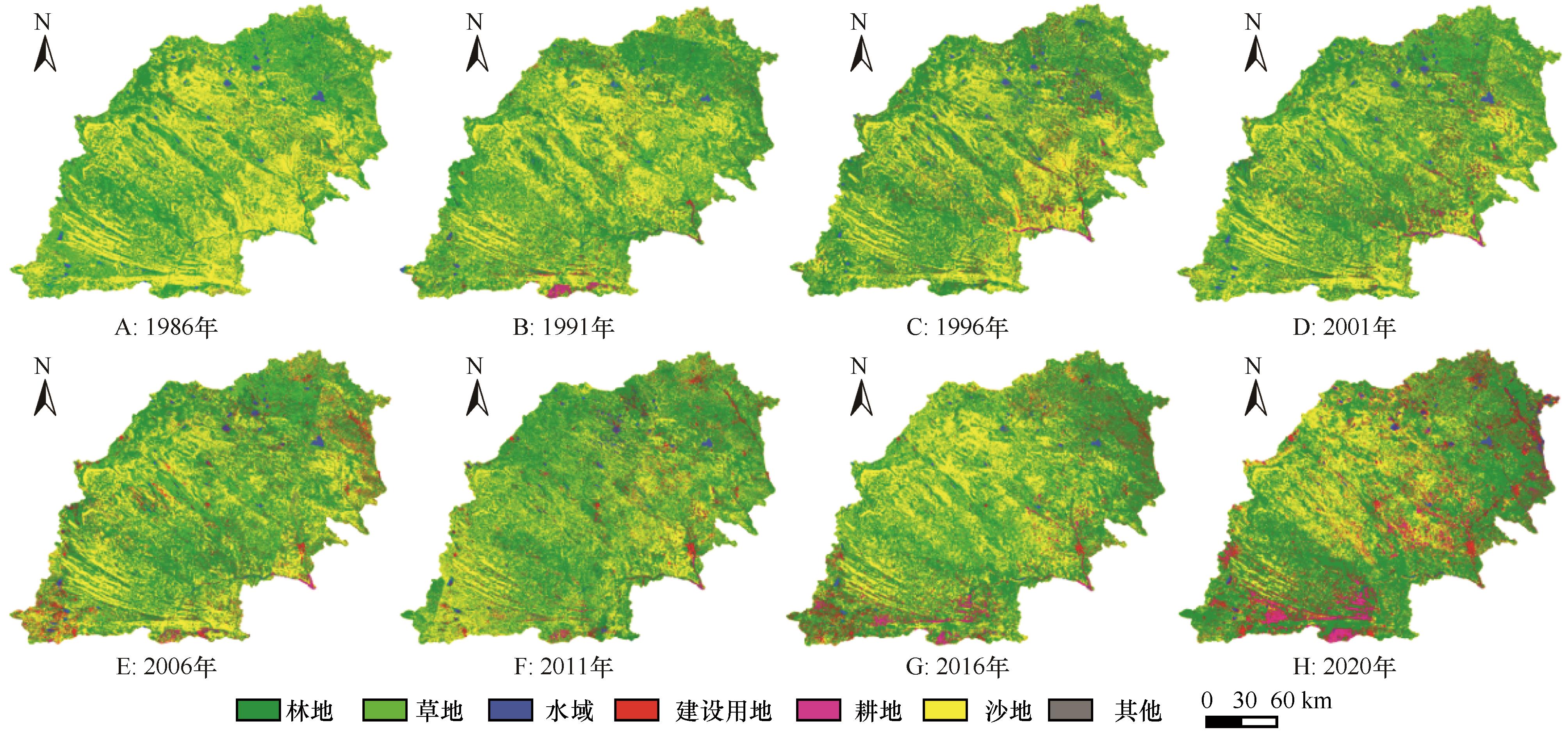
Fig.2 Spatial distribution map of land use in different periods
| 土地利用 类型 | 时段 | ||||||
|---|---|---|---|---|---|---|---|
| 1986—1991年 | 1991—1996年 | 1996—2001年 | 2001—2006年 | 2006—2011年 | 2011—2016年 | 2016—2020年 | |
| 综合 | 0.80 | 0.35 | 0.40 | 0.42 | 0.70 | 1.59 | 1.93 |
| 沙地 | -1.12 | -0.61 | -0.34 | -0.98 | -1.98 | -2.85 | -6.71 |
| 水域 | -2.87 | -0.64 | -0.74 | 0.51 | -2.67 | -0.73 | -0.82 |
| 林地 | 1.18 | 0.55 | 0.61 | 0.22 | 3.32 | 1.09 | 3.23 |
| 耕地 | 2.54 | 1.98 | 0.16 | 10.28 | -1.07 | 6.83 | 9.86 |
| 草地 | 3.14 | 0.81 | 0.94 | 0.60 | -2.17 | 2.22 | -2.85 |
| 建设用地 | 3.44 | 1.22 | 2.90 | 0.94 | 1.61 | 3.48 | 10.72 |
| 其他 | -3.68 | -1.71 | -5.30 | -1.25 | -8.64 | 2.22 | -11.48 |
Talbe 4 Dynamics of land use in different landscapes in the Mu Us Sandy Land from 1986 to 2020
| 土地利用 类型 | 时段 | ||||||
|---|---|---|---|---|---|---|---|
| 1986—1991年 | 1991—1996年 | 1996—2001年 | 2001—2006年 | 2006—2011年 | 2011—2016年 | 2016—2020年 | |
| 综合 | 0.80 | 0.35 | 0.40 | 0.42 | 0.70 | 1.59 | 1.93 |
| 沙地 | -1.12 | -0.61 | -0.34 | -0.98 | -1.98 | -2.85 | -6.71 |
| 水域 | -2.87 | -0.64 | -0.74 | 0.51 | -2.67 | -0.73 | -0.82 |
| 林地 | 1.18 | 0.55 | 0.61 | 0.22 | 3.32 | 1.09 | 3.23 |
| 耕地 | 2.54 | 1.98 | 0.16 | 10.28 | -1.07 | 6.83 | 9.86 |
| 草地 | 3.14 | 0.81 | 0.94 | 0.60 | -2.17 | 2.22 | -2.85 |
| 建设用地 | 3.44 | 1.22 | 2.90 | 0.94 | 1.61 | 3.48 | 10.72 |
| 其他 | -3.68 | -1.71 | -5.30 | -1.25 | -8.64 | 2.22 | -11.48 |
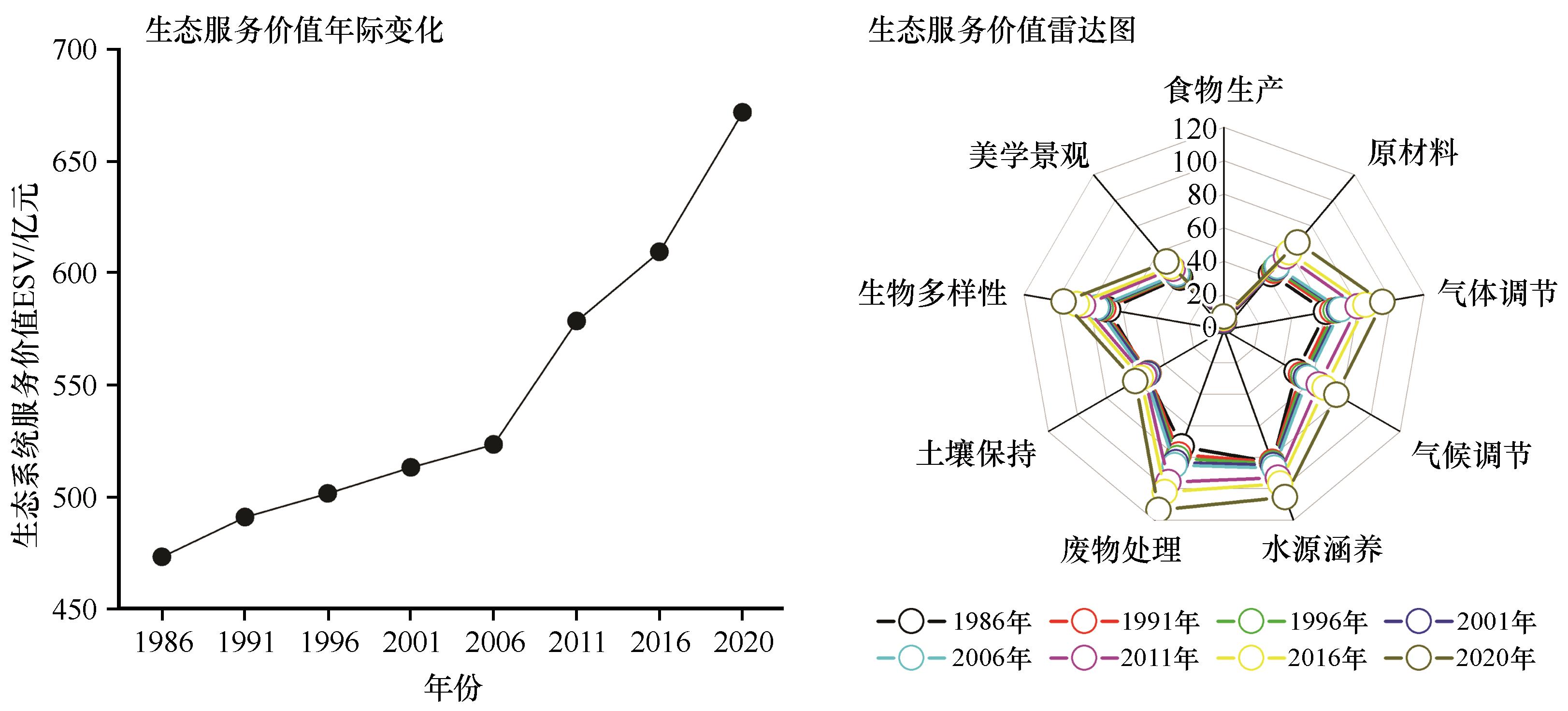
Fig.3 Time series changes of ecological service value in Mu Us Sandy Land
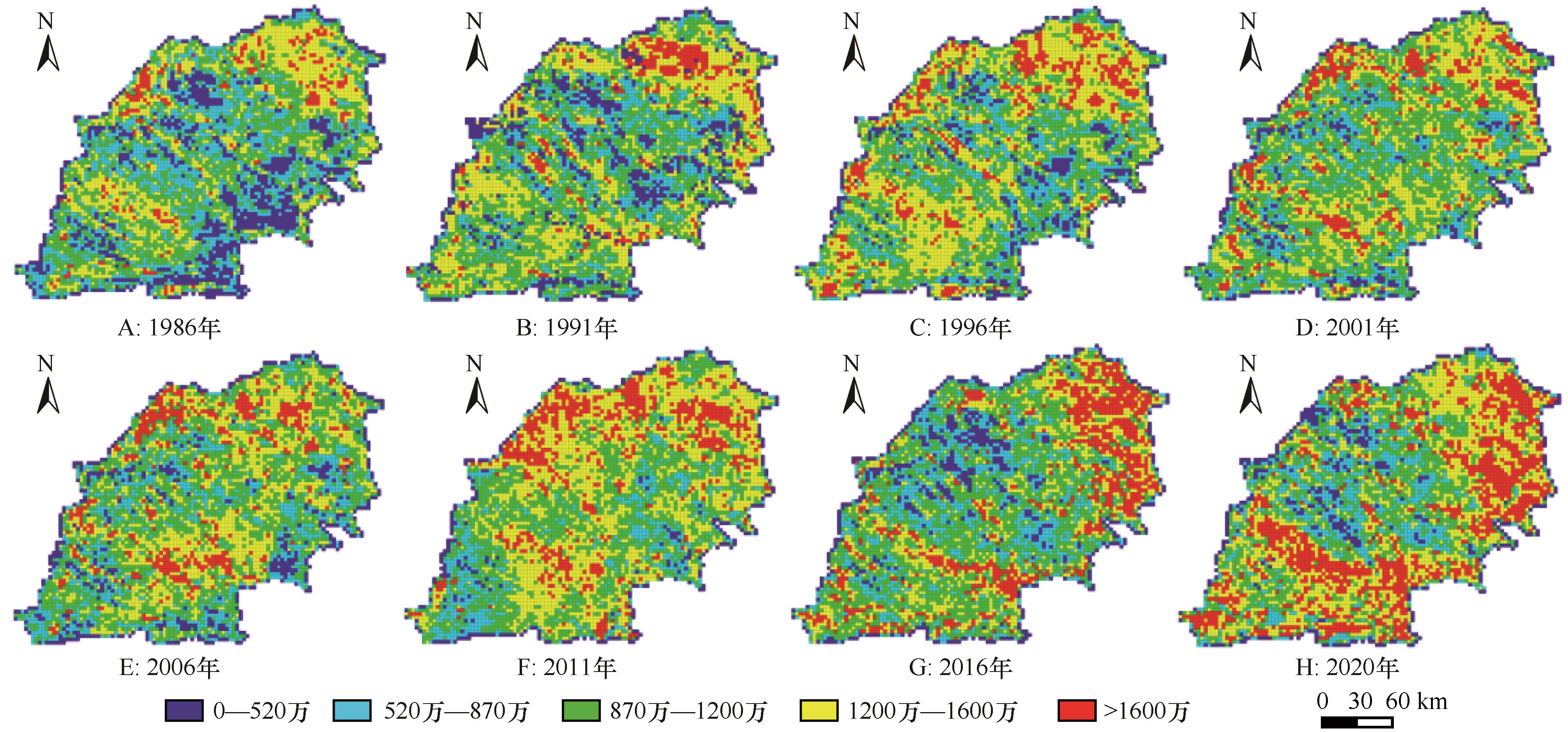
Fig.4 Spatial distribution of ecological service value in Mu Us Sandy Land
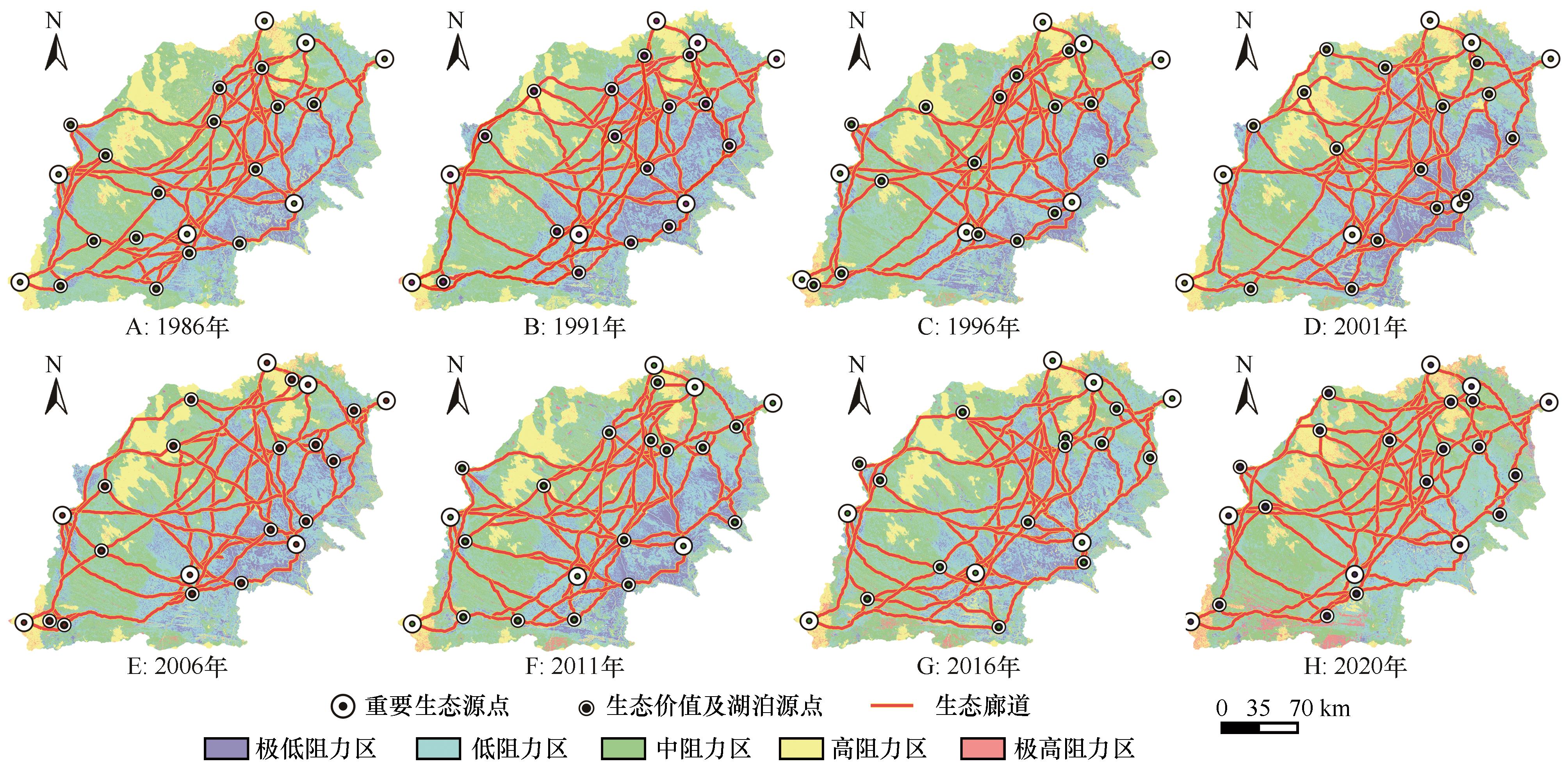
Fig.5 Spatial distribution of ecological network in Mu Us Sandy Land
| 1 | Zhang Y Z, Jiang Z Y, Li Y Y,et al.Construction and optimization of an urban ecological security pattern based on habitat quality assessment and the Minimum Cumulative Resistance Model in Shenzhen City,China[J].Forests,2021,12(7):1-9. |
| 2 | Ma Q W, Li Y H, Xu L H.Identification of green infrastructure networks based on ecosystem services in a rapidly urbanizing area[J].Journal of Cleaner Production,2021,300:1-11. |
| 3 | Miao Z H, Pan L, Wang Q Z,et al.Research on urban ecological network under the threat of road networks: a case study of Wuhan[J].ISPRS International Journal of Geo-Information,2019,8:342-357 . |
| 4 | 于成龙,刘丹,冯锐,等.基于最小累积阻力模型的东北地区生态安全格局构建[J].生态学报,2021,41(1):290-301. |
| 5 | 任涛,贾志峰,王智,等.毛乌素沙地地膜-地布覆盖下土壤水势动态[J].水土保持学报,2020,34(4):78-84. |
| 6 | 杨梅焕,张美晨.毛乌素沙地东南缘NDVI植被变化特征分析[J].地理空间信息,2020,18(5):105-108. |
| 7 | 楚纯洁,赵景波,吴楠楠,等.毛乌素沙地晚第四纪地层特征与沙漠化研究综述[J].地质科技情报,2017,36(5):14-21. |
| 8 | 韩昭庆.明代毛乌素沙地变迁及其与周边地区垦殖的关系[J].中国社会科学,2003(5):191-204,209. |
| 9 | 沈钦炜,林美玲,莫惠萍,等.佛山市生态网络构建及优化[J].应用生态学报 2021,32(9):3288-3298. |
| 10 | Liu Y W, Li J K, Xia J H,et al.Risk assessment of non-point source pollution based on landscape pattern in the Hanjiang River basin,China[J].Environmental Science and Pollution Research,2021,28:64322-64336. |
| 11 | 钱佳洋,秦富仓,王迪海,等.1998-2018年永寿县景观格局变化及驱动力分析[J].西北林学院学报,2020,35(6):279-286. |
| 12 | Ye H, Yang Z P, Xu X L.Ecological corridors analysis based on MSPA and MCR Mode:a case study of the Tomur World Natural Heritage Region[J].Sustainability,2020,12(3):959. |
| 13 | 刘双嘉,张贵军,张蓬涛,等.基于生态系统服务的京津冀地区生态安全格局构建研究[J].林业与生态科学,2021,36(2):144-153. |
| 14 | 和娟,师学义,付扬军.基于生态系统服务的汾河源头区域生态安全格局优化[J].自然资源学报,2020,35(4):814-825. |
| 15 | 赵文祯,韩增林,闫晓露,等.基于生态系统服务多情景权衡的生态安全格局构建:以大连市瓦房店为例[J].自然资源学报,2020,35(3):546-562. |
| 16 | Hu F G.Artificial intelligence system-based oasis soil water quality measurement and network marketing behavior analysis[J].Arabian Journal of Geosciences,2021,14(15):1-11. |
| 17 | 张金燕,毋兆鹏,于辉,等.干旱区精河流域绿洲化过程中土壤养分时空变异研究[J].中国农业资源与区划,2020,41(2):252-260. |
| 18 | 肖平.毛乌素湖盆滩地浅埋地下水位下降对近地表温度及地表能量平衡的影响[D].西安:长安大学,2020. |
| 19 | 王涛,吴薇,薛娴,等.近50年来中国北方沙漠化土地的时空变化[J].地理学报,2004,59(2):203-212. |
| 20 | 李娜,颜长珍.毛乌素沙地现代人为活动的生态环境效应研究进展[J].中国沙漠,2015,35(2):487-492. |
| 21 | Yin J F, Zhan X W, Zheng Y F,et al.Improving Noah land surface model performance using near real time surface albedoand green vegetation fraction[J].Agricultural and Forest Meteorology,2016,218:171-183. |
| 22 | 谢高地,鲁春霞,冷允法,等.青藏高原生态资产的价值评估[J].自然资源学报,2003(2):189-196. |
| 23 | 温璐,宋洁,张慧超,等.近30年乌兰布和沙漠生态系统服务价值评估[J].干旱区资源与环境,2020,34(12):57-64. |
| 24 | Li X Q, Wang M Z, Liu X J,et al.MCR-Modified CA-Markov Model for the simulation of urban expansion[J]. Sustainability,2018,10(9):1-13. |
| 25 | 宋洁,温璐,王凤歌,等.乌兰布和沙漠生态系统服务价值时空动态[J].生态学报,2021,41(6):2201-2211. |
| 26 | 刘淑琴,白存琳,边振,等.沙漠边缘脆弱区土地利用变化及其生态环境效应:以毛乌素沙漠南缘盐池县为例[J].草业科学,2020,37(11):2175-2184. |
| 27 | 卢周,扬帆,许端阳,等.阿拉善干旱荒漠区土地利用变化对生态系统服务的影响[J].水土保持研究,2019,26(6):296-302. |
| 28 | Michele De L, Giuseppina I, Claudia S,et al.A single MCR-ALS model for drug analysis in different formulations:application on diazepam commercial preparations[J].Journal of Pharmaceutical and Biomedical Analysis,2017,134:1-9. |
| [1] | Ming Yan, Yinghua Zhang, Li He, Weiming Cheng, Suiji Wang, Jiongxin Xu. Blocking effect of upper reaches of Wuding River on desertification [J]. Journal of Desert Research, 2022, 42(2): 62-68. |
| [2] | Hairong Liang, Tao Wang, Yu Yang, Wei Feng, Honglin Lian, Xuefeng Liu, Jiatao Li, Jia Liu. Comparison of deep soil recharge characteristics between Mu Us Sandy Land and Hunshandake Sandy Land [J]. Journal of Desert Research, 2022, 42(2): 69-76. |
| [3] | Xiaoqin Yuan, Shengquan Liu, Feng Ai, Zheng Zhang, Qiang Li, Jinyu Jiang, Changchun Shi. Wind erosion resistance of litter of Salix psammophila community in the southeast edge of Mu Us Sandy Land, China [J]. Journal of Desert Research, 2022, 42(1): 134-138. |
| [4] | Chengpeng Sun, Wenzhi Zhao. Effect of land use on soil infiltration in the desert-oasis of Hexi Corridor [J]. Journal of Desert Research, 2021, 41(6): 148-156. |
| [5] | Yanhui Lei, Guodong Ding, Zimeng Li, Wenfeng Chi, Guanglei Gao, Yuanyuan Zhao. Land use/cover change and its ecosystem service value response in the Beijing-Tianjin sandstorm source control project area [J]. Journal of Desert Research, 2021, 41(6): 29-40. |
| [6] | Lin Shi, Yuxing Zhao, Eerdun Hasi, Ping Zhang, Yingjun Xu, Zhuoran Wang. Changes of vegetation and soil nutrient on windward slope of dune under sand barrier environment in Mu Us Sandy Land [J]. Journal of Desert Research, 2021, 41(5): 140-146. |
| [7] | Liping Liu, Liangxu Liu, Jie Lian, Jiannan Lu, Guolin Wang. Land cover type change characteristics and driving factors in Hetao oasis [J]. Journal of Desert Research, 2021, 41(5): 210-218. |
| [8] | Haowei Jia, Changzhen Yan, Xuegang Xing, Jiali Xie, Kun Feng. Evaluation of ecological environment in the Dulan County based on the Modified Remote Sensing Ecological Index Model [J]. Journal of Desert Research, 2021, 41(2): 181-190. |
| [9] | Mengzhu Liu, Yanfang Wang, Hongwei Pei. The changes of land use and carbon storage in the northern farming-pastoral ecotone under the background of returning farmland to forest (grass) [J]. Journal of Desert Research, 2021, 41(1): 174-182. |
| [10] | Yabin Chang, Rui Zhu, Shengchun Xiao, Yapei Li. Sandy land change from 1980 to 2015 in Alxa League, China and its driving factors [J]. Journal of Desert Research, 2020, 40(6): 82-90. |
| [11] | Hong Zhou, Bo Wu, Ying Gao, Long Cheng, Xiaohong Jia, Yingjun Pang, Heju Zhao. Composition and influencing factors of the biological soil crust bacterial communities in the Sabina vulgaris community in Mu Us Sandy Land [J]. Journal of Desert Research, 2020, 40(5): 130-141. |
| [12] | Mingjing Xu, Lü Ping, Nan Xiao, Junhuai Yang, Zhengyao Liu, Miaoyan Feng, Zhun Liang. Effect of vegetation cover on dune migration in northwest Mu Us Sandy Land [J]. Journal of Desert Research, 2020, 40(4): 71-80. |
| [13] | Kong Junqia, Du Zeyu, Yang Rong, Su Yongzhong. Prediction of Land Use Change and Its Influence on Carbon Stocks in the Middle Reaches of Heihe River [J]. Journal of Desert Research, 2019, 39(3): 87-97. |
| [14] | Wang Guoling, Su Zhizhu, Mao Li, Zhang Qiuhua, Ma Yijuan. Characteristics of Soil Surface Grain Size in Ordos Plateau along the Agro-pastoral Ecotone of North China [J]. Journal of Desert Research, 2019, 39(3): 183-190. |
| [15] | Han Rui, Su Zhizhu, Li Xiang, Liu Miaomiao, Ma Yijuan. Holocene Climate Change Revealed by Grain Size and Magnetic Susceptibility in the Eastern Mu Us Sandy Land [J]. Journal of Desert Research, 2019, 39(2): 105-114. |
| Viewed | ||||||
|
Full text |
|
|||||
|
Abstract |
|
|||||
©2018Journal of Desert Research
Tel:0931-8267545
Email:caiedit@lzb.ac.cn;desert@lzb.ac.cn
Support:Magtech