
- CN 62-1070/P
- ISSN 1000-694X
- Bimonthly 1981
Journal of Desert Research ›› 2026, Vol. 46 ›› Issue (3): 88-96.DOI: 10.7522/j.issn.1000-694X.2025.00200
Previous Articles Next Articles
Biyou Zhang( ), Guangyin Hu(), Jingjing Hu
Received:2025-10-24
Revised:2025-12-22
Online:2026-05-20
Published:2026-06-11
Contact:
Guangyin Hu
CLC Number:
Biyou Zhang, Guangyin Hu, Jingjing Hu. Wind regime and sand drift potential characteristics in the Madoi Basin of the source region of Yellow River[J]. Journal of Desert Research, 2026, 46(3): 88-96.
Add to citation manager EndNote|Ris|BibTeX
URL: http://www.desert.ac.cn/EN/10.7522/j.issn.1000-694X.2025.00200
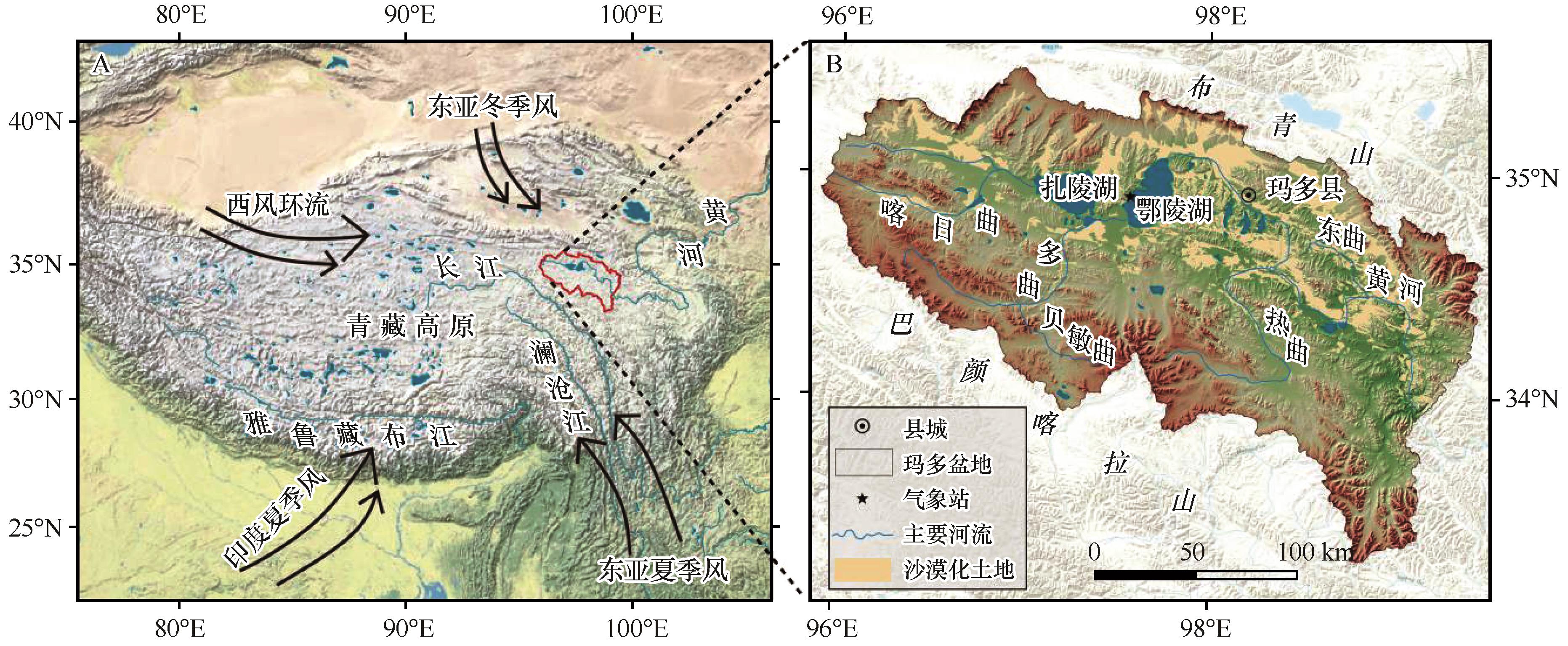
Fig.1 The location of the Madoi Basin on the Tibetan Plateau (A), and the distribution of its aeolian desertified land (B)
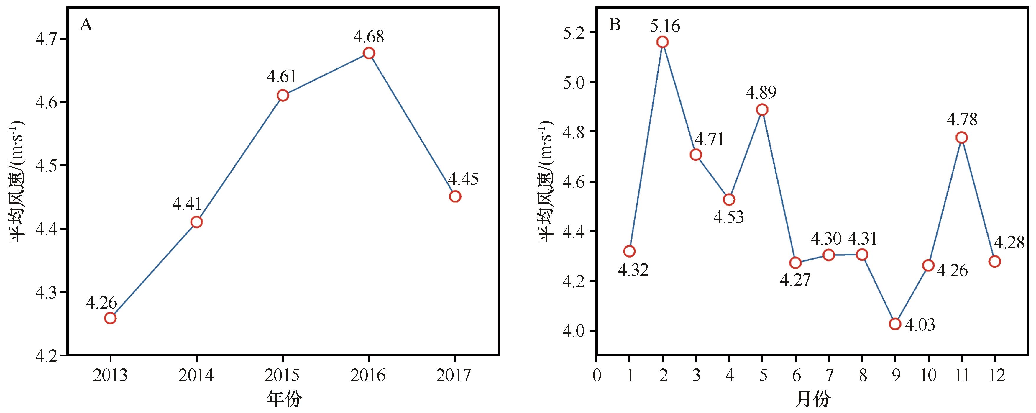
Fig.2 Average wind speed (A) and monthly average wind speed (B) in the Madoi Basin
| 年份 | 起沙风频率/% | 起沙风平均风速/(m·s-1) | |||||||||
|---|---|---|---|---|---|---|---|---|---|---|---|
| 春季 | 夏季 | 秋季 | 冬季 | 全年 | 春季 | 夏季 | 秋季 | 冬季 | 全年 | ||
| 平均值 | 29.0 | 20.8 | 20.8 | 29.5 | 23.5 | 8.35 | 7.65 | 7.93 | 8.70 | 8.22 | |
| 2013 | 25.8 | 22.9 | 20.6 | 30.8 | 19.9 | 8.33 | 7.61 | 7.80 | 9.02 | 8.27 | |
| 2014 | 28.4 | 20.7 | 21.0 | 29.9 | 22.7 | 8.02 | 7.55 | 8.06 | 8.40 | 8.05 | |
| 2015 | 29.8 | 17.3 | 21.9 | 30.9 | 25.5 | 8.54 | 7.55 | 7.91 | 8.82 | 8.32 | |
| 2016 | 28.7 | 20.7 | 21.8 | 28.8 | 26.1 | 8.30 | 7.78 | 8.07 | 8.58 | 8.22 | |
| 2017 | 32.4 | 22.3 | 18.4 | 27.0 | 23.4 | 8.50 | 7.74 | 7.73 | 8.73 | 8.25 | |
Table 1 Frequency and average wind speed of sand-driving winds in the Madoi Basin
| 年份 | 起沙风频率/% | 起沙风平均风速/(m·s-1) | |||||||||
|---|---|---|---|---|---|---|---|---|---|---|---|
| 春季 | 夏季 | 秋季 | 冬季 | 全年 | 春季 | 夏季 | 秋季 | 冬季 | 全年 | ||
| 平均值 | 29.0 | 20.8 | 20.8 | 29.5 | 23.5 | 8.35 | 7.65 | 7.93 | 8.70 | 8.22 | |
| 2013 | 25.8 | 22.9 | 20.6 | 30.8 | 19.9 | 8.33 | 7.61 | 7.80 | 9.02 | 8.27 | |
| 2014 | 28.4 | 20.7 | 21.0 | 29.9 | 22.7 | 8.02 | 7.55 | 8.06 | 8.40 | 8.05 | |
| 2015 | 29.8 | 17.3 | 21.9 | 30.9 | 25.5 | 8.54 | 7.55 | 7.91 | 8.82 | 8.32 | |
| 2016 | 28.7 | 20.7 | 21.8 | 28.8 | 26.1 | 8.30 | 7.78 | 8.07 | 8.58 | 8.22 | |
| 2017 | 32.4 | 22.3 | 18.4 | 27.0 | 23.4 | 8.50 | 7.74 | 7.73 | 8.73 | 8.25 | |
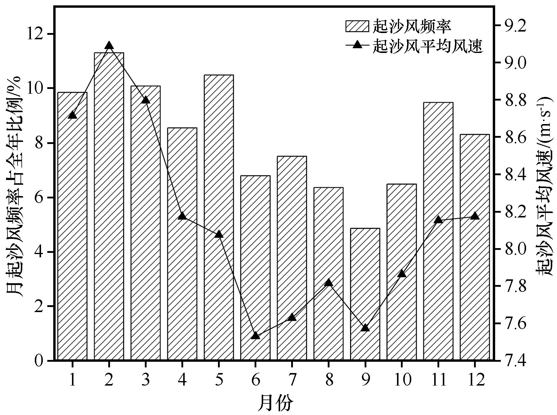
Fig.3 Monthly variations of frequency and average wind speed of sand driving winds in the Madoi Basin
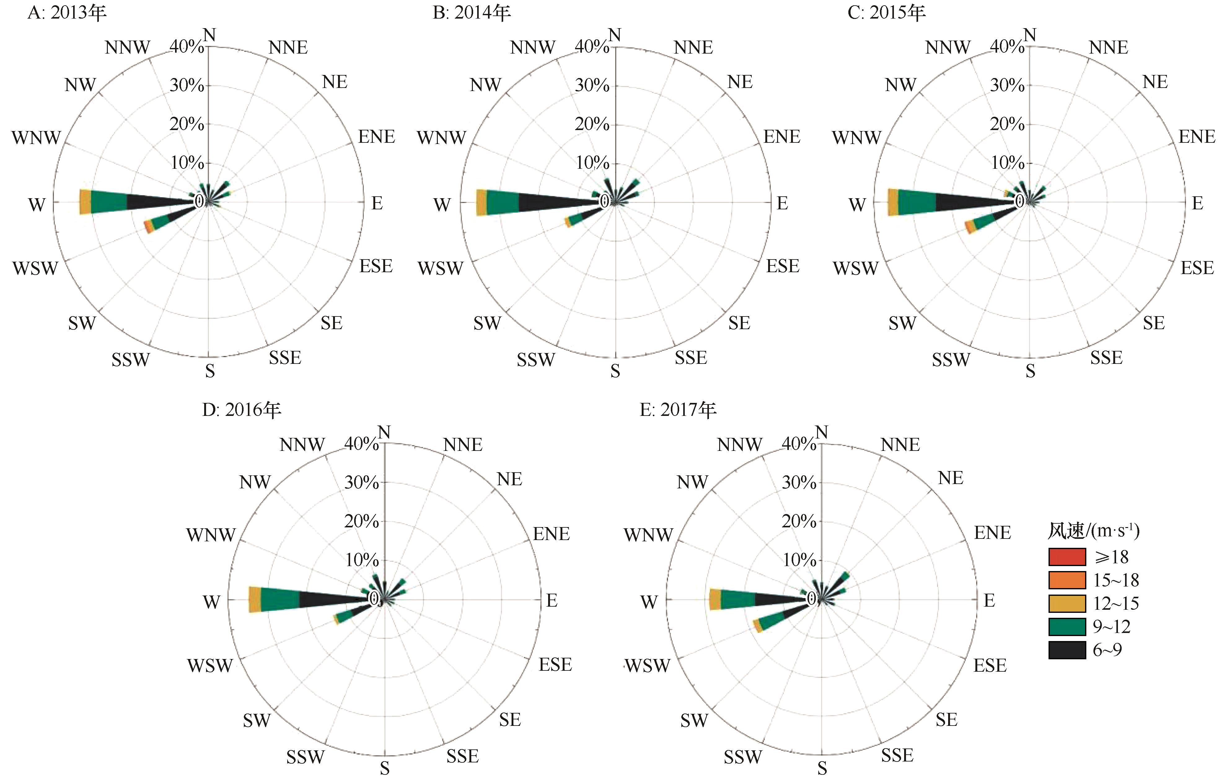
Fig.4 Sand driving wind rose diagrams in the Madoi Basin
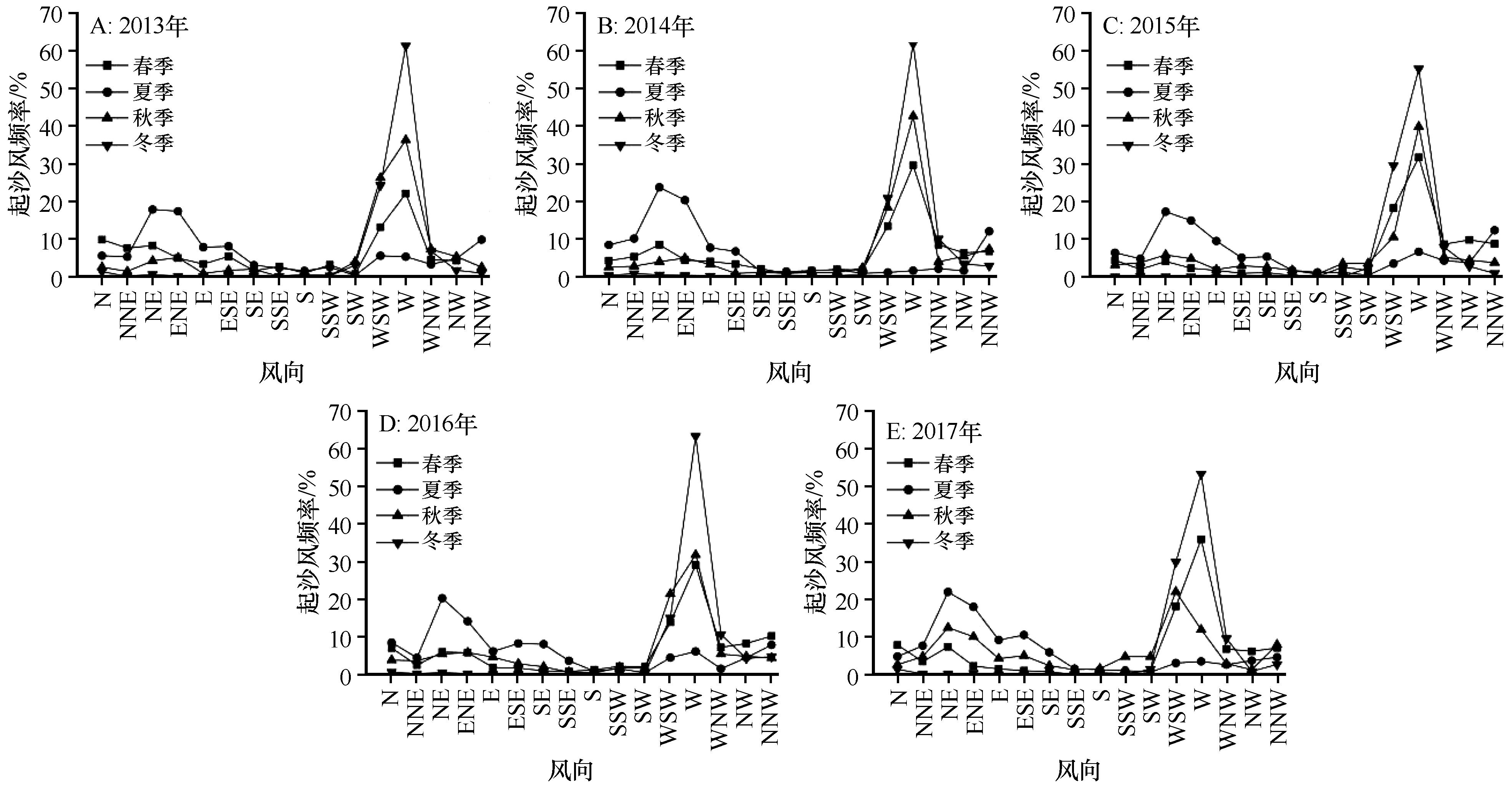
Fig.5 Seasonal variation of sand-driving wind frequency and direction in the Madoi Basin
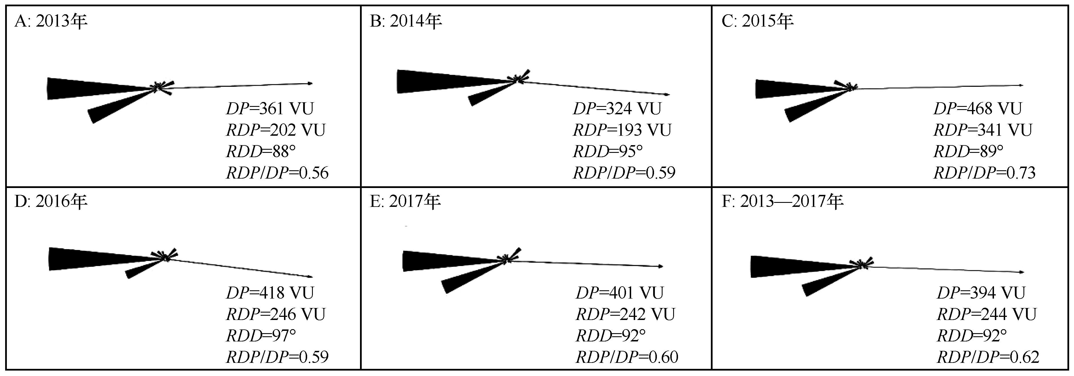
Fig.6 Annual sand drift potential rose diagram in the Madoi Basin
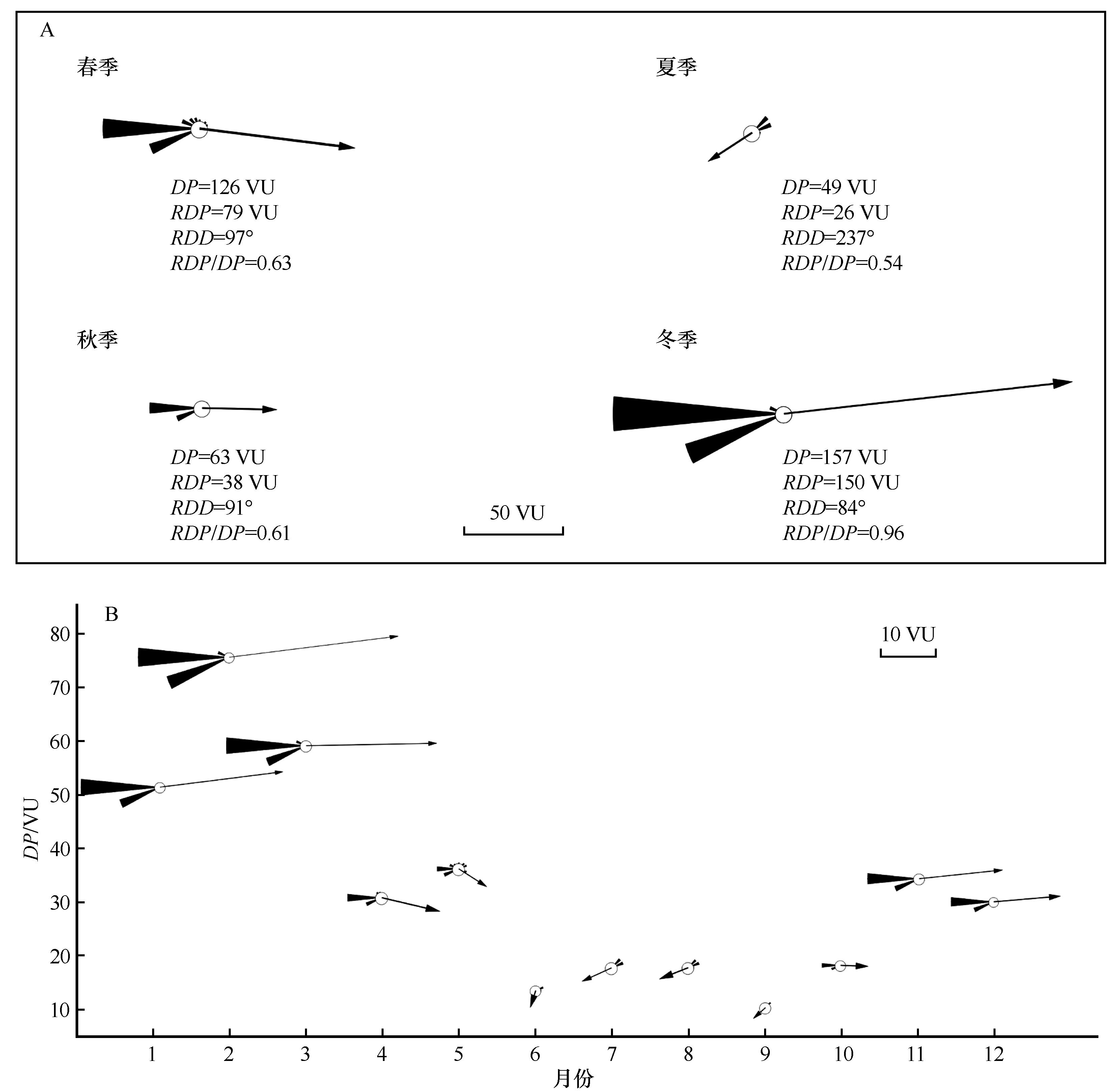
Fig.7 The sand drift potential rose diagram of the Madoi Basin by season (A) and by month (B)
| 研究区 | DP/VU | RDP/VU |
|---|---|---|
| 玛多盆地 | 394 | 244 |
| 若尔盖盆地 | 66 | 36 |
| 共和盆地 | 87 | 84 |
| 红梁河风沙活动地区 | 250 | 243 |
| 雅鲁藏布江干旱河谷米林段 | 35 | 9 |
| 通天河七渡口 | 93 | 31 |
| 青藏铁路格拉段 | 232~727 | 189~651 |
| 雅鲁藏布江流域 | 0.5~840 | 0.1~652 |
Table 2 Sediment transport potential in the Qinghai-Tibet Plateau
| 研究区 | DP/VU | RDP/VU |
|---|---|---|
| 玛多盆地 | 394 | 244 |
| 若尔盖盆地 | 66 | 36 |
| 共和盆地 | 87 | 84 |
| 红梁河风沙活动地区 | 250 | 243 |
| 雅鲁藏布江干旱河谷米林段 | 35 | 9 |
| 通天河七渡口 | 93 | 31 |
| 青藏铁路格拉段 | 232~727 | 189~651 |
| 雅鲁藏布江流域 | 0.5~840 | 0.1~652 |
| [1] | Dong Z B, Hu G Y, Qian G Q,et al.High-altitude aeolian research on the Tibetan Plateau[J].Reviews of Geophysics,2017,55(4):864-901. |
| [2] | Pearce K I, Walker I J.Frequency and magnitude biases in the ‘Fryberger’ model,with implications for characterizing geomorphically effective winds[J].Geomorphology,2005,68(1):39-55. |
| [3] | Xie S B, Qu J J, Lai Y M,et al.Formation mechanism and suitable controlling pattern of sand hazards at Honglianghe River section of Qinghai-Tibet Railway[J].Natural Hazards,2015,76(2):855-871. |
| [4] | Hu Z H, Gao X, Lei J Q,et al.Geomorphology of aeolian dunes in the western Sahara Desert[J].Geomorphology,2021,392:107916. |
| [5] | 马芳,吕萍,曹敏,等.柴达木盆地新月形和穹状沙丘共存形态和成因[J].中国沙漠,2025,45(1):185-194. |
| [6] | 潘加朋,张克存,安志山,等.风沙治理工程综合效益分析:以敦煌黑山嘴风沙口为例[J].中国沙漠,2023,43(2):233-242. |
| [7] | Abbasi H, Gohardoust A, Mohammadpour F,et al.Erosive wind characteristics and aeolian sediment transport and dune formation in Makran Region of Baluchistan,Iran[J].Atmosphere,2025,16(6):650. |
| [8] | Sadid N.Sand dune migration and flux into the lower Helmand and Arghandab valleys[J].Sedimentologika,2024,2(1). |
| [9] | 张令光,沈才生,黄艳丽,等.雅鲁藏布江流域输沙势空间特征[J].中国沙漠,2025,45(1):304-317. |
| [10] | Hu G Y, Dong Z B, Zhang Z C,et al.Wind regime and aeolian landforms on the eastern shore of Qinghai Lake,Northeastern Tibetan Plateau,China[J].Journal of Arid Environments,2021,188:104451. |
| [11] | Tao W.Aeolian desertification and its control in Northern China[J].International Soil and Water Conservation Research,2014,2(4):34-41. |
| [12] | Zhang C L, Li Q, Shen Y P,et al.Monitoring of aeolian desertification on the Qinghai-Tibet Plateau from the 1970s to 2015 using Landsat images[J].Science of The Total Environment,2018,619/620:1648-1659. |
| [13] | Minola L, Zhang G F, Ou T H,et al.Climatology of near-surface wind speed from observational,reanalysis and high-resolution regional climate model data over the Tibetan Plateau[J].Climate Dynamics,2024,62(2):933-953. |
| [14] | Chen F H, Zhang J F, Liu J B,et al.Climate change,vegetation history,and landscape responses on the Tibetan Plateau during the Holocene:a comprehensive review[J].Quaternary Science Reviews,2020,243:106444. |
| [15] | 唐道斌,杨坤美,曾兰华,等.1.5 ka以来青藏高原东北部风沙活动增强的时空差异[J].地理学报,2023,78(9):2284-2298. |
| [16] | Hu J J, Hu G Y, Yang L H,et al.Periglacial aeolian activities in the Headwater Region of the Yellow River,northeastern Tibetan Plateau[J].Palaeogeography,Palaeoclimatology,Palaeoecology,2025,671:112984. |
| [17] | 青藏高原风沙地貌图集[M].西安:西安地图出版社,2017. |
| [18] | 朱刚,高会军,曾光.近45 a来黄河源区沙质荒漠化土地景观格局变化[J].干旱区资源与环境,2021,35(12):79-85. |
| [19] | Hu G Y, Jin H J, Dong Z B,et al.Driving forces of aeolian desertification in the source region of the Yellow River:1975-2005[J].Environmental Earth Sciences,2013,70(7):3245-3254. |
| [20] | Dörwald L, Lehmkuhl F, Delobel L,et al.Dune behavior in the Source Area of the Yellow River under climate changes observed from various remote sensing datasets[J].Aeolian Research,2024,67/69:100928. |
| [21] | 胡光印,董治宝,逯军峰,等.黄河流域沙漠化空间格局与成因[J].中国沙漠,2021,41(4):213-224. |
| [22] | 胡菁菁,胡光印,董治宝.黄河源区玛多盆地沙漠化土地粒度特征[J].中国沙漠,2022,42(4):242-252. |
| [23] | 孟宪红,吕世华.鄂陵湖流域湖畔观测点常规气象观测数据[DS/OL].国家冰川冻土沙漠科学数据中心,2022.. |
| [24] | 吴正,等.风沙地貌与治沙工程学[M].北京:科学出版社,2003. |
| [25] | Qian G Q, Yang Z L, Xing X G,et al.Seasonal morphological evolution and migration of granule ripples in the Sanlongsha Dune Field,northern Kumtagh Sand Sea,China[J].Geomorphology,2024,444:108951. |
| [26] | Fryberge S G.Dune forms and wind regime[M]//Dune Forms and Wind Regime.Washington,D.C.USA:United States Government Printing Office,1979:137-169. |
| [27] | Zhang G F, Azorin-Molina C, Chen D L,et al.Variability and trends of near-surface wind speed over the Tibetan Plateau:the role played by the westerly and Asian monsoon[J].Advances in Climate Change Research,2024,15(3):525-536. |
| [28] | Wasson R J, Hyde R.Factors determining desert dune type[J].Nature,1983,304(5924):337-339. |
| [29] | 董治宝,钱广强.关于土壤水分对风蚀起动风速影响研究的现状与问题[J].土壤学报,2007(5):934-942. |
| [30] | 胡光印,董治宝,张正偲,等.若尔盖盆地起沙风风况与输沙势特征[J].中国沙漠,2020,40(5):20-24. |
| [31] | 谢胜波,喻文波,屈建军,等.青藏高原红梁河风沙动力环境特征[J].中国沙漠,2018,38(2):219-224. |
| [32] | 陈宗颜,董治宝,汪青春.青海共和盆地风况及风沙地貌[J].中国沙漠,2018,38(3):492-499. |
| [33] | 卢佳雪,刘雅丹,王学林,等.雅鲁藏布江干旱河谷米林段风况及输沙势特征[J].干旱区资源与环境,2025,39(4):145-155. |
| [34] | 张可盈,张娴,谢胜波.柳格高速公路沿线风沙环境特征[J].中国沙漠,2025,45(5):277-288. |
| [35] | 陈宗颜,董治宝,汪青春,等.柴达木盆地风况及输沙势特征[J].中国沙漠,2020,40(1):195-203. |
| [36] | 王涛,谢胜波,屈建军,等.通天河七渡口风沙环境特征及沙害防治[J].中国沙漠,2019,39(2):70-78. |
| [37] | 蔡迪文,张克存,安志山,等.青藏铁路格拉段风动力环境及其对铁路沙害的影响[J].中国沙漠,2017,37(1):40-47. |
| [38] | Xie S B, Qu J J, Xu X T,et al.Interactions between freeze-thaw actions,wind erosion desertification,and permafrost in the Qinghai-Tibet Plateau[J].Natural Hazards,2017,85(2):829-850. |
| [39] | Xue X, Guo J, Han B W,et al.The effect of climate warming and permafrost thaw on desertification in the Qinghai-Tibetan Plateau[J].Geomorphology,2009,108(3):182-190. |
| [1] | Yifei Wu, Ping Lü, Junlin Yu, Xinyao Wang, Yichen Wei. Comparative study on the morphology and wind regime of barchan dunes in coexisting regions with linear dunes and single-type regions [J]. Journal of Desert Research, 2026, 46(3): 195-208. |
| [2] | Xinyao Wang, Ping Lv, Junlin Yu, Yifei Wu, Yichen Wei. Coexistence patterns and wind regimes of dome dunes with barchan, linear, reticulate [J]. Journal of Desert Research, 2026, 46(3): 75-87. |
| [3] | Qian Zhou, Yanbing Jiang, Lihai Tan, Hongtao Wang, Ke Li. Characteristics of aeolian environment in the Taitema Lake dry lake-basin section of the Golmud-Korla Railway [J]. Journal of Desert Research, 2025, 45(2): 102-110. |
| [4] | Zhenyang Li, Hongwei Zhang, Siru Shang, Tongpan Zhang, Shuai Yang, Lihai Tan, Junzhan Wang, Deli Ye, Xiulan Pang, Tao Wang. Environmental characteristics and movement rules of wind-blown sand in gobi concentrated solar power plant [J]. Journal of Desert Research, 2025, 45(2): 17-28. |
| [5] | Fang Ma, Ping Lv, Min Cao, Junlin Yu, Zishu Xia. Coexistence of barchan dunes and dome dunes and its causes in the Qaidam Basin [J]. Journal of Desert Research, 2025, 45(1): 185-194. |
| [6] | Guangqiang Qian, Zhuanling Yang, Xuegang Xing, Zhibao Dong, Kaijia Pan, Yuxuan Meng, Youyuan Guo. Creep of aeolian sediments on the surface of granule ripples and its geomorphological significance [J]. Journal of Desert Research, 2024, 44(6): 287-298. |
| [7] | Heng Ren, Shengji Jiang, Wenzhi Zhao. A review of desertification research on the Tibetan Plateau [J]. Journal of Desert Research, 2024, 44(6): 318-329. |
| [8] | Junyan Chen, Yawen Guan, Yue Zhang, Yu Chen, Hongru Bi, Gaotong Lou, Xinyang Guo, Yang Wang, Siyu Chen. Transport of dust from Gobi Desert to the Tibetan Plateau and its dynamic mechanism: a case study of a dust event in April of 2020 [J]. Journal of Desert Research, 2024, 44(3): 158-171. |
| [9] | Yongtao Gou, Yongxiang Wu, Bo Peng, Yong Zhang, Huiping Kong, Xinghong Zhao, Pengju Ji, Yunhao Li, Mingzhu He, Mei Shao, Mingliang Tan, Junfeng Lu. Characteristics of aeolian sand activity in typical section of protection system of Wuhai-Maqen Highway (G1816) in Tengger Desert [J]. Journal of Desert Research, 2024, 44(3): 279-289. |
| [10] | Huicong Meng, Guangyin Hu, Zhibao Dong, Weige Nan, Haokun Mo, Jingjing Hu. Characteristics of grain size variation of dunes surface sediments before and after wandering dune control in Zoige Basin, China [J]. Journal of Desert Research, 2024, 44(3): 96-107. |
| [11] | Yongtao Gou, Yongxiang Wu, Bo Peng, Hao Yang, Jinku Ma, Chaohui Wang, Hailong Bai, Mingzhu He, Mingliang Tan, Mei Shao, Junfeng Lu. Evaluation of sand-fixation effect of different configuration measures of protection system in Wuhai-Maqen Highway in Tengger Desert [J]. Journal of Desert Research, 2024, 44(2): 264-272. |
| [12] | Jiahui Cao, Siyu Chen, Chao Zhang, Lulu Lian, Dan Zhao, Shikang Du. External contribution of the Tibetan Plateau dust [J]. Journal of Desert Research, 2024, 44(2): 57-65. |
| [13] | Haokun Mo, Guangyin Hu, Huicong Meng. Research progress on aeolian activity in the Qinghai Lake area, northeastern Tibetan Plateau [J]. Journal of Desert Research, 2023, 43(6): 197-209. |
| [14] | Qiang Li. Characteristics of aeolian environment in typical sand-hazard sections along the Jiuquan-Dongfeng section of Jiuquan-Ejin Banner Railway [J]. Journal of Desert Research, 2023, 43(6): 220-228. |
| [15] | Jiyan Li, Dehua Xu, Yaoyao Zhang, Qianwen Xue, Ling Zhou. Characteristics of wind regime and sand drift potential in the Qaidam Basin, northwestern China [J]. Journal of Desert Research, 2023, 43(5): 223-231. |
| Viewed | ||||||
|
Full text |
|
|||||
|
Abstract |
|
|||||
©2018Journal of Desert Research
Tel:0931-8267545
Email:caiedit@lzb.ac.cn;desert@lzb.ac.cn
Support:Magtech