img

官方微信

高级检索

中国沙漠 ›› 2023, Vol. 43 ›› Issue (2): 65-73.DOI: 10.7522/j.issn.1000-694X.2022.00117

• • 上一篇    下一篇

毛乌素沙地水体面积变化及驱动因子

白旭赢1(), 王玉杰1, 王云琦1, 杨文斌2,3, 王涛4, 程一本1,3()   

  1. 1.北京林业大学 水土保持学院,北京 100083
    2.内蒙古低覆盖治沙科技开发有限公司,内蒙古 呼和浩特 010050
    3.中国林业科学研究院,北京 100091
    4.中国科学院西北生态环境资源研究院,甘肃 兰州 730000
  • 收稿日期:2021-05-24 修回日期:2022-08-01 出版日期:2023-03-20 发布日期:2023-04-12
  • 通讯作者: 程一本
  • 作者简介:程一本(E-mail: chengyiben@bjfu.edu.cn
    白旭赢(1998—),女,辽宁义县人,硕士研究生,研究方向为荒漠化防治。E-mail: baibailucky324@163.com
  • 基金资助:
    磴口县水资源承载力与林草资源优化配置研究项目(CAFYBB2020ZB007-2);内蒙古自治区科技重大专项(2019ZD003);国家重点研发计划政府间国际科技创新合作专项(2019YFE0116500);国家自然科学基金项目(U2243202);低覆盖度防风治沙林模式推广示范([2019]33号);中国林业科学院荒漠化研究所结余经费新立项目(S2022JY-8);北京林业大学大学生创新训练项目(X202110022026)

Changes and driving factors of water body area in Mu Us Sandy Land

Xuying Bai1(), Yujie Wang1, Yunqi Wang1, Wenbin Yang2,3, Tao Wang4, Yiben Cheng1,3()   

  1. 1.School of Soil and Water Conservation,Beijing Forestry University,Beijing 100083,China
    2.Inner Mongolia Low Coverage Sand Control Technology Development Co. ,Ltd. ,Hohhot 010050,China
    3.Chinese Academy of Forestry Sciences,Beijing 100091,China
    4.Northwest Institute of Eco-Environment and Resources,Chinese Academy of Sciences,Lanzhou 730000,China
  • Received:2021-05-24 Revised:2022-08-01 Online:2023-03-20 Published:2023-04-12
  • Contact: Yiben Cheng

摘要:

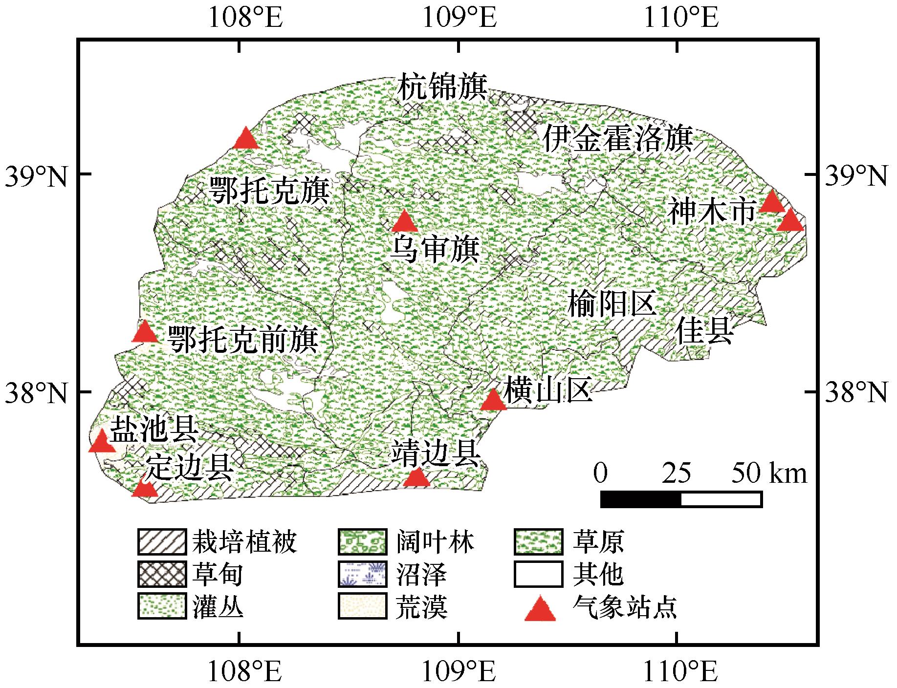
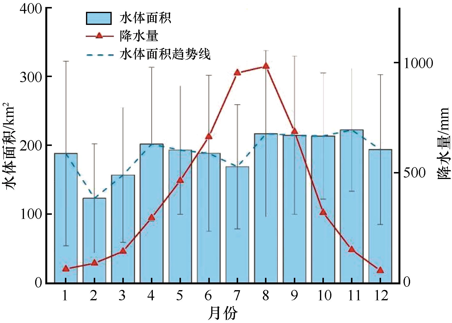
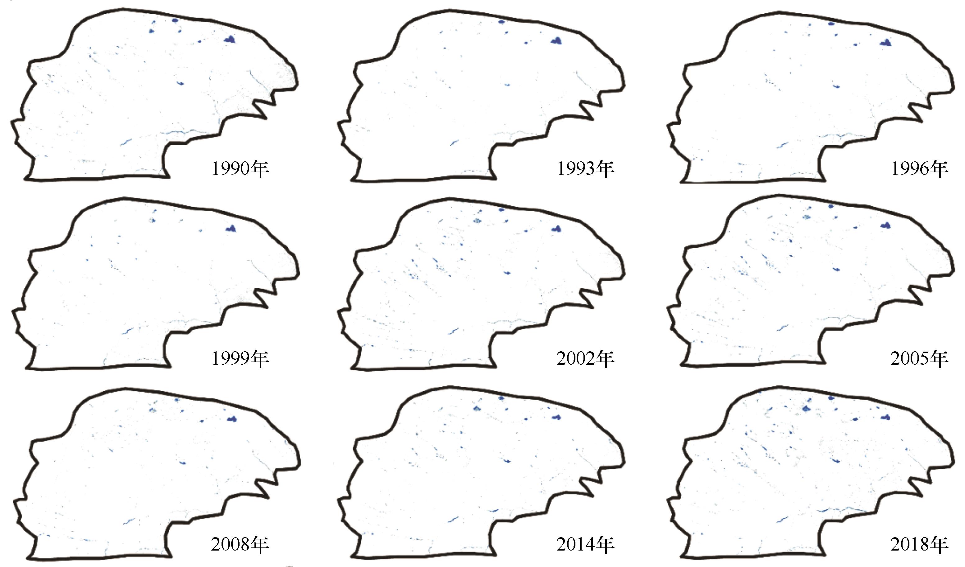
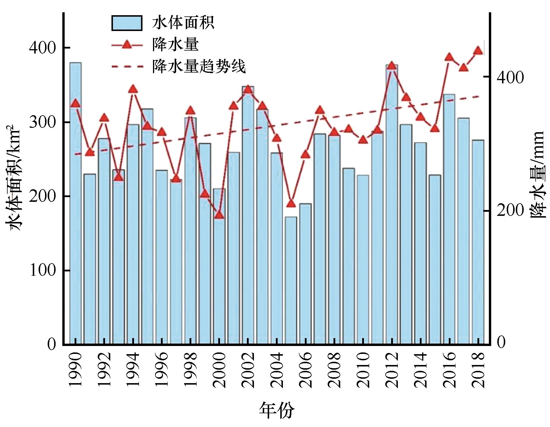
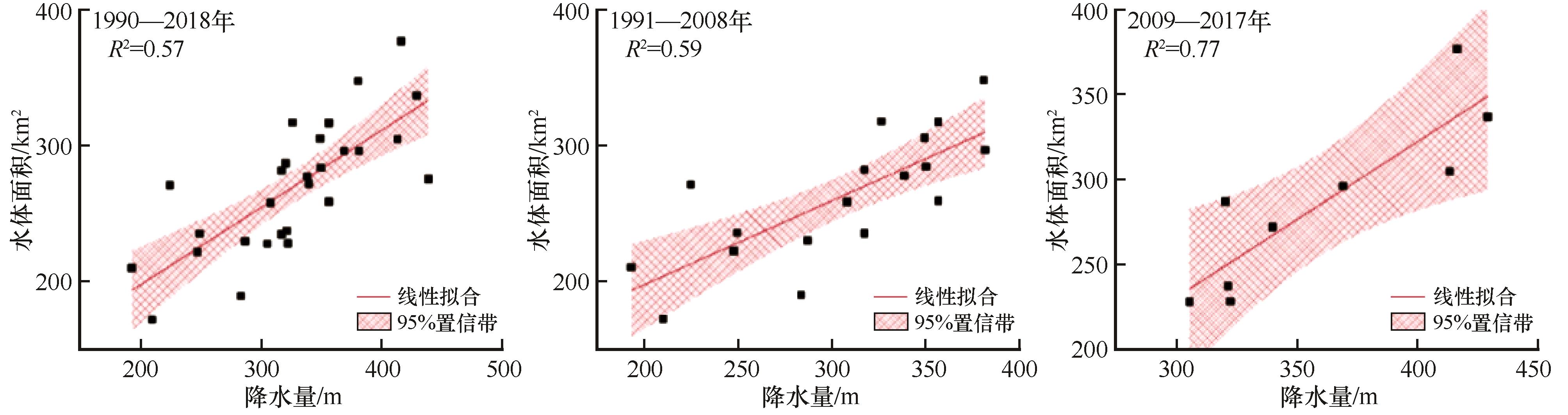
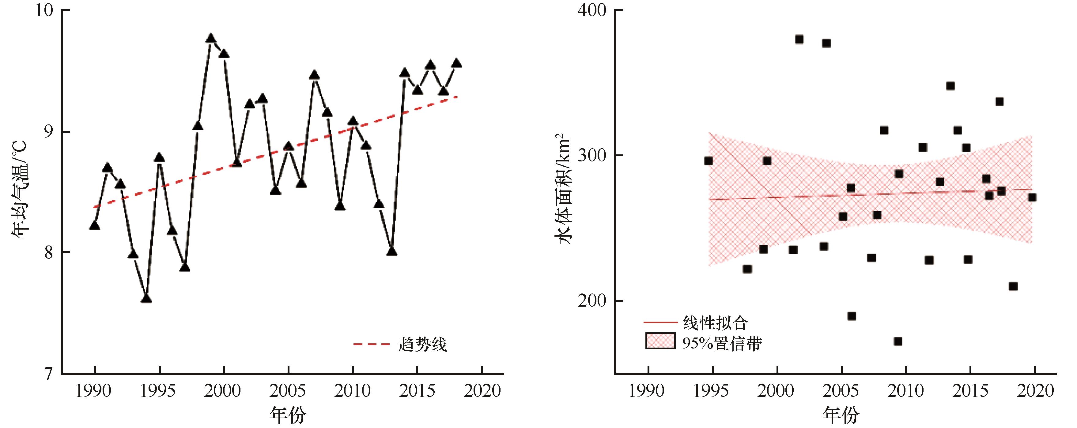
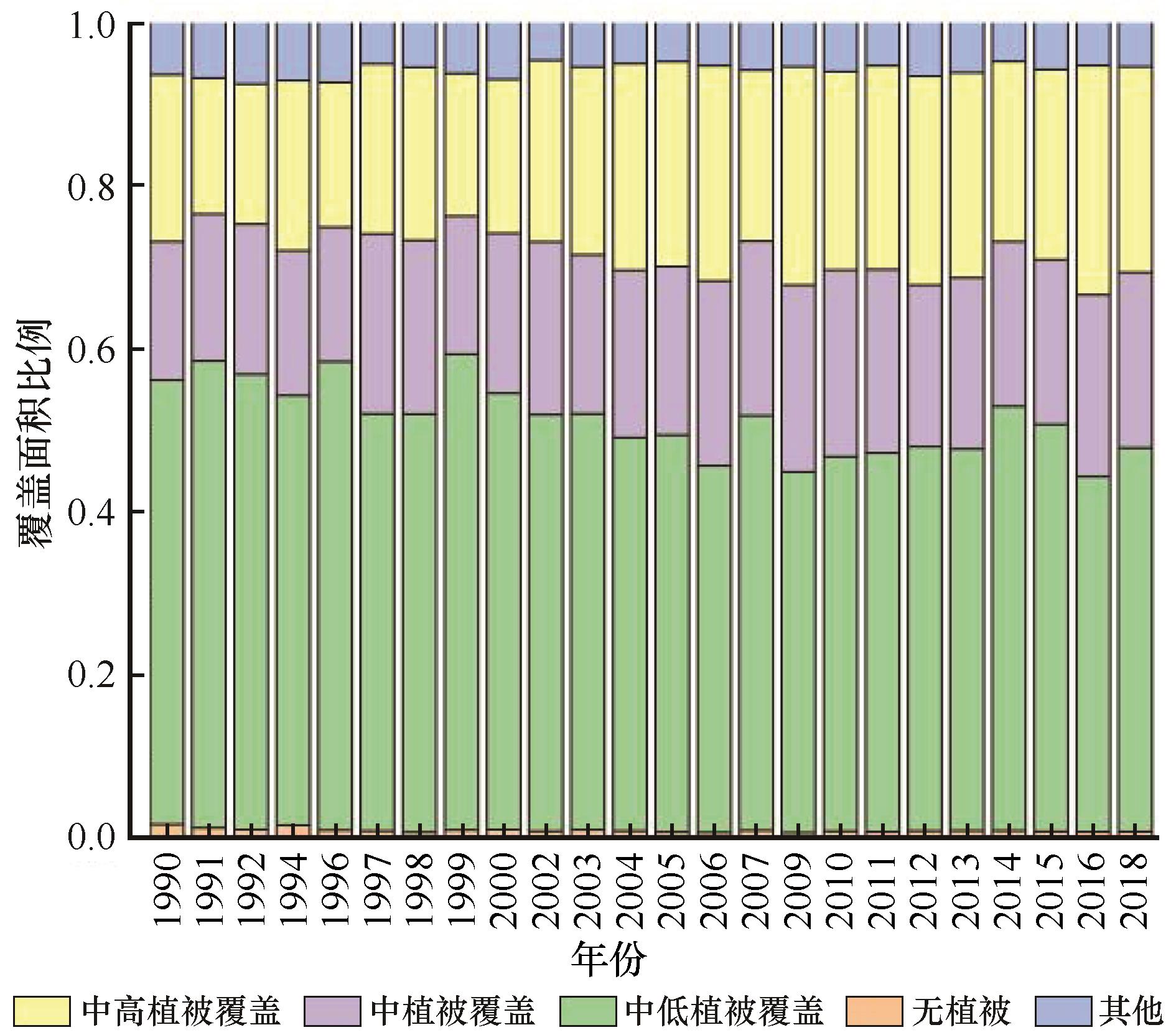
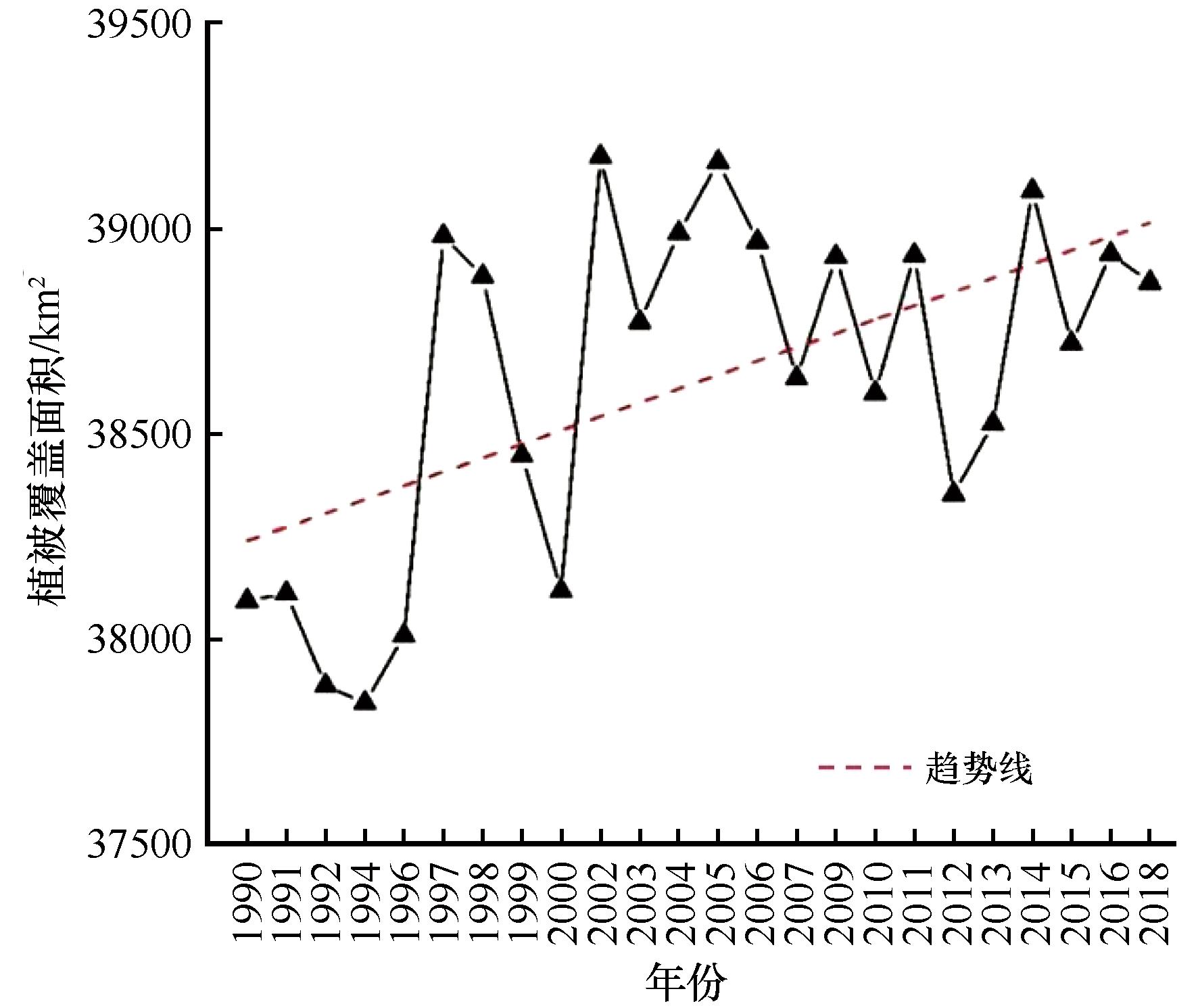
干旱半干旱地区水分在土壤-植物-大气连续体(SPAC)中转换较快,地表水地下水转换时间短,水体面积变化对干旱半干旱地区浅层地下水具有重要的指示作用。利用Google Earth Engine平台处理1990—2018年共29期Landsat遥感影像,获取毛乌素沙地长时间序列下地表水体变化特征。结果表明:毛乌素沙地水体面积具有很强的季节性特征,年内两次峰值分别出现在4月和8月,比上月面积分别增加44.867 km2(28.60%)和55.477 km2(34.39%)。1990—2018年地表水体面积波动较大,研究区内水体面积从379.771 km2缩减到275.492 km2,共缩减了104.278 km2(27.46%)。研究区水体面积变化主要受降水、植被覆盖和人类活动的影响,29 a内降水量和水体面积相关系数为0.57(P<0.05),而1991—2008和2009—2017年二者相关系数分别为0.59和0.77(P<0.05);29 a内植被覆盖和水体面积整体呈负相关,但相关性不显著,其中1990、1997、1998、2003—2007、2009、2011—2015年16 a内相关系数为0.57(P<0.05),表明毛乌素沙地人类活动影响较大。为了治理沙地,应该减少人类活动。

关键词: 毛乌素沙地, 水体面积, 植被覆盖, 水资源

Abstract:

The soil-plant-atmosphere continuum (SPAC) in arid and semi-arid regions converts water rapidly, while the conversion time of surface water and groundwater is short. The change of water body area plays an important role in indicating shallow groundwater in arid and semi-arid regions. A total of 29 periods of Landsat remote sensing images from 1990 to 2018 were processed through the Google Earth Engine platform, which obtain the variation characteristics of the subsurface water bodies in the Mu Us Sandy Land in a short-term sequence. The results show: The variation of water bodies in the Mu Us Sandy Land has strong seasonal characteristics. The two peaks occurred in April and August during the year, respectively. The monthly area increased by 44.867 km2 (28.60%) and 55.477 km2 (34.39%) respectively. From 1990 to 2018, the surface water body fluctuated greatly, and the total area of the water body in the study area was reduced from 379.771 km2 to 275.492 km2, a total reduction of 104.278 km2 (27.46%). The change of water body area in the study area is mainly affected by precipitation, vegetation coverage and human activities. The correlation coefficient between precipitation and water body area within 29 years is 0.57, while the correlation coefficients between 1991-2008 and 2009-2017 are 0.59 and 0.77. Vegetation coverage and water body area were negatively correlated within 29 years, but the correlation was not significant. It shows that human activities in the Mu Us Sandy Land have a greater impact. In order to control the sandy land, human activities should be reduced.

Key words: Mu Us Sandy Land, water body area, vegetation coverage, water resources

中图分类号: