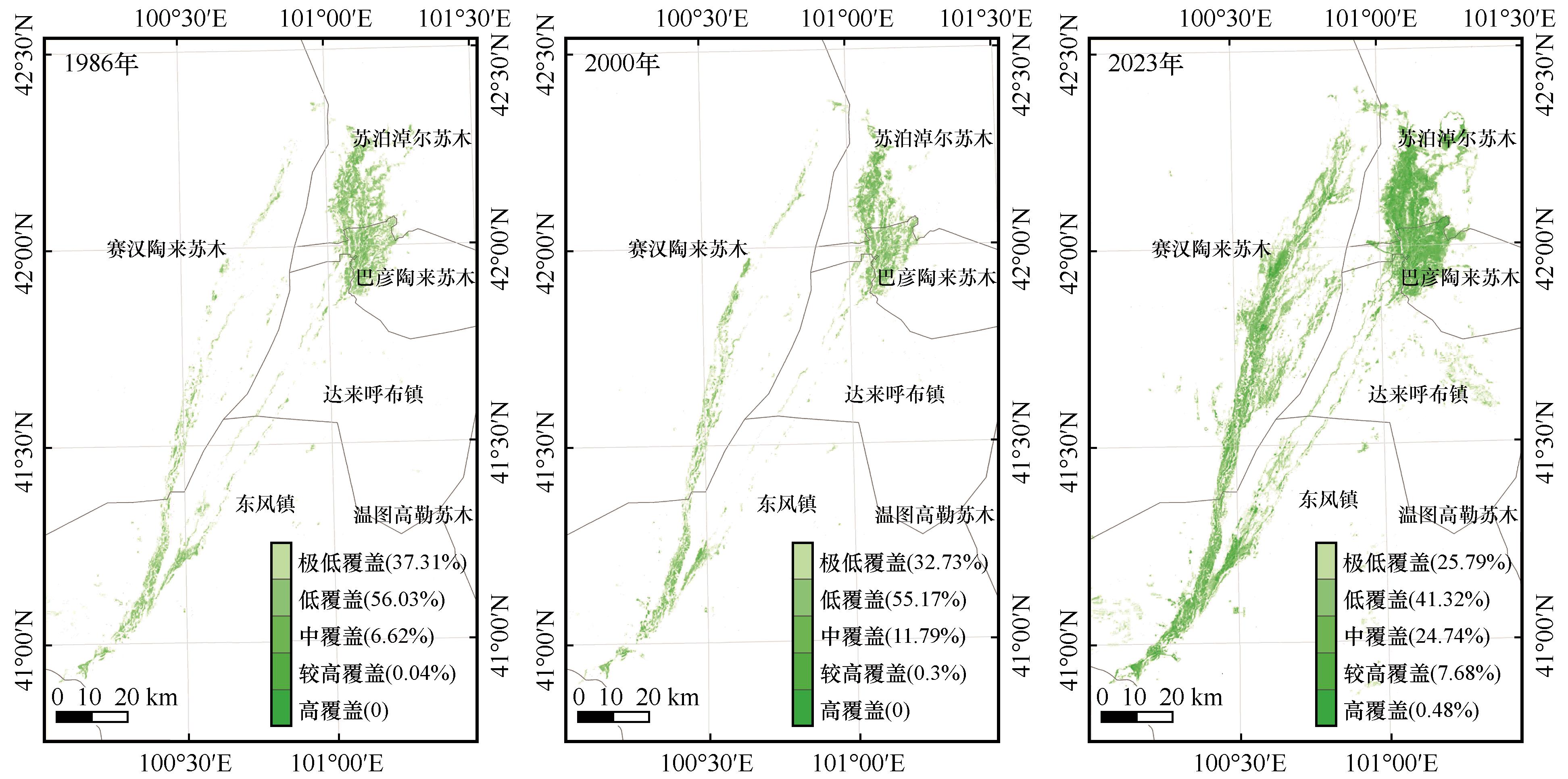
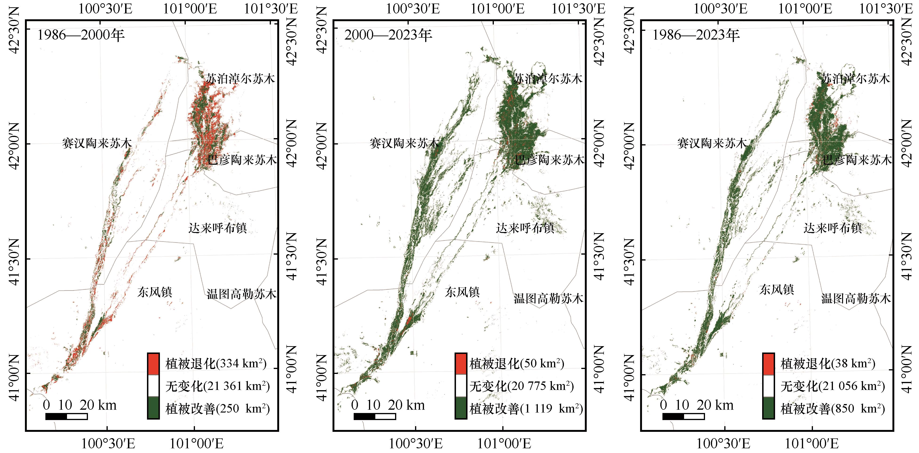
| 1 |
高思琦,董国涛,蒋晓辉,等.黄河源植被覆盖度变化及空间分布自然驱动力分析[J].生态环境学报,2022,31(3):429-439.
|
| 2 |
程兀杰,孟妮娜,蔡昕楠,等.陕西省NDVI时空变化及其对气候和人类活动的响应[J].人民黄河,2023,45(4):28-34.
|
| 3 |
Zhou Y Z, Li X, Yang K,et al.Assessing the impacts of an ecological water diversion project on water consumption through high-resolution estimations of actual evapotranspiration in the downstream regions of the Heihe River Basin,China[J].Agricultural and Forest Meteorology,2018,249:210-227.
|
| 4 |
Evans F H, Shen J X.Long-term hindcasts of wheat yield in fields using remotely sensed phenology,climate data and machine learning[J].Remote Sensing,2021,13(13):2435.
|
| 5 |
Chen W, Wang Z, Zhang X P,et al.Improving fractional vegetation cover estimation with shadow effects using high dynamic range images[J].IEEE Journal of Selected Topics in Applied Earth Observations and Remote Sensing,2022,15:1701-1711.
|
| 6 |
Yan K, Gao S, Chi H J,et al.Evaluation of the vegetation-index-based dimidiate pixel model for fractional vegetation cover estimation[J].IEEE Transactions on Geoscience and Remote Sensing,2021,60:1-14.
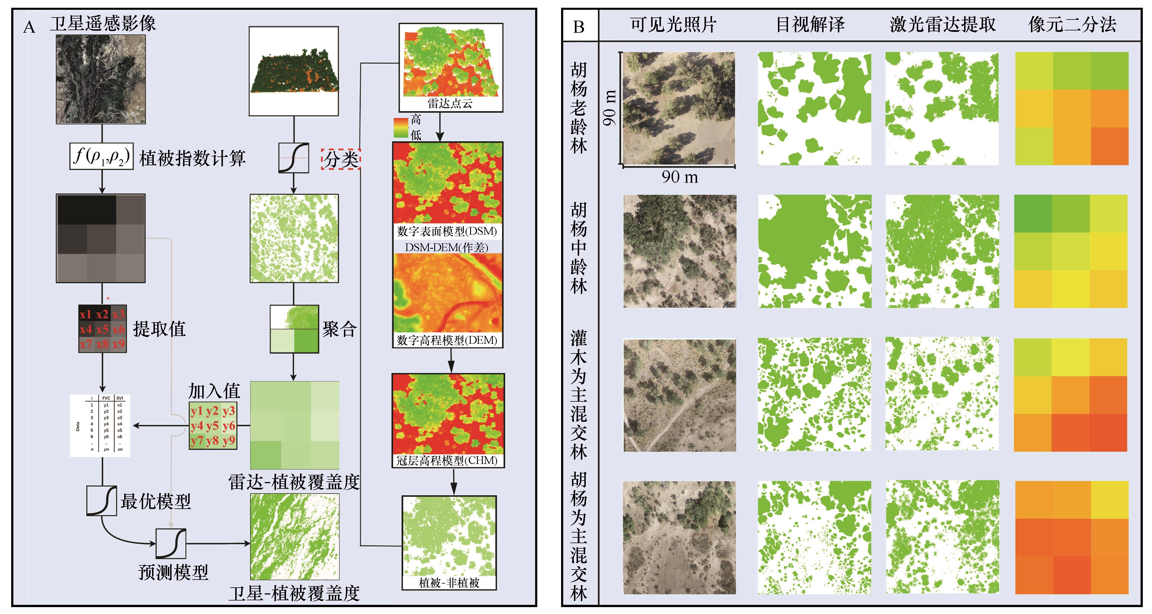
|
| 7 |
Dandois J P, Olano M, Ellis E C.Optimal altitude,overlap,and weather conditions for computer vision UAV estimates of forest structure[J].Remote Sensing,2015,7(10):13895-13920.
|
| 8 |
尹林江,李威,赵卫权,等.水稻多时相植被指数特征及覆盖度提取研究[J].中国农业科技导报,2023,25(2):83-98.
|
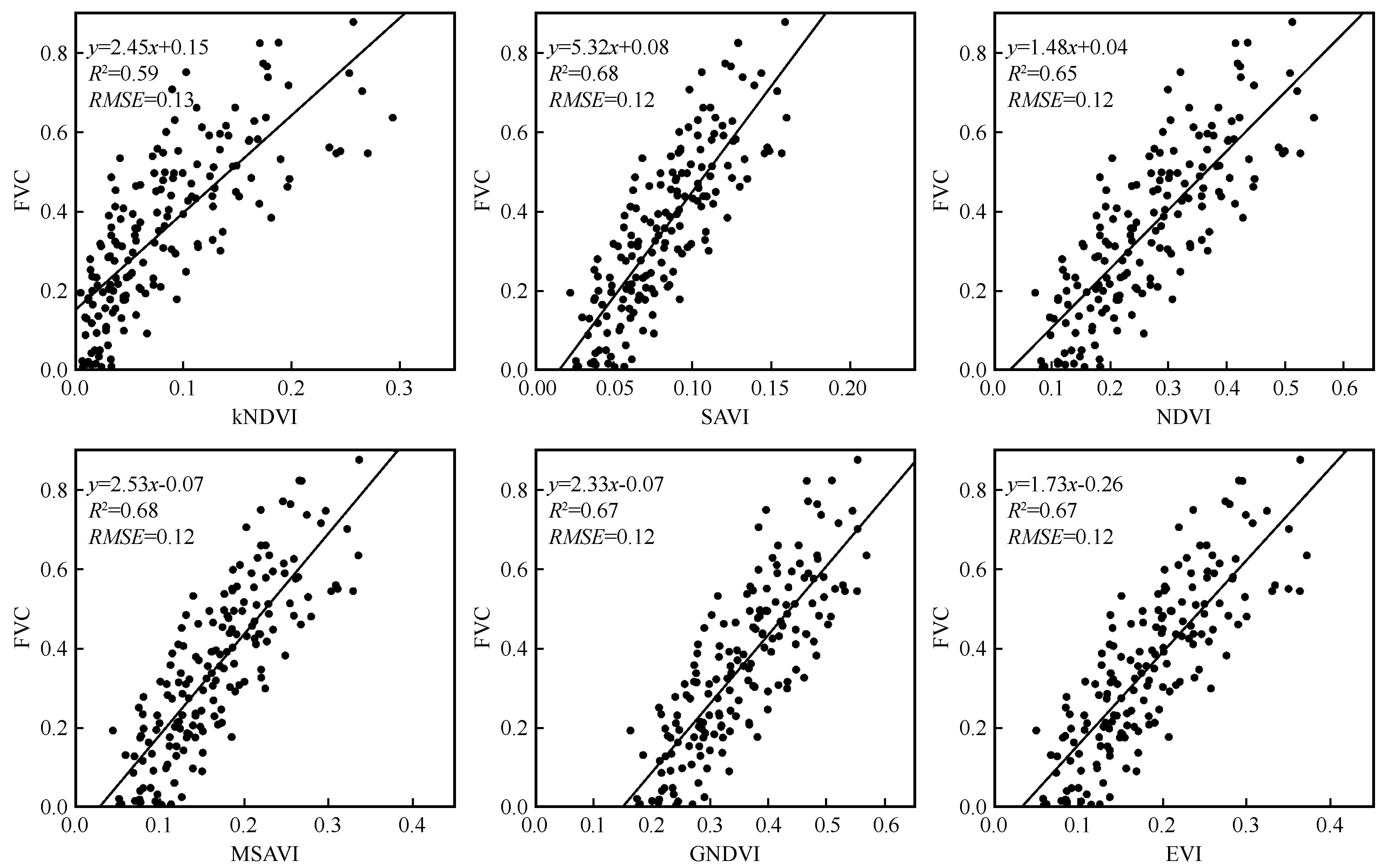
| 9 |
Wang N, Guo Y C, Wei X,et al.UAV-based remote sensing using visible and multispectral indices for the estimation of vegetation cover in an oasis of a desert[J].Ecological Indicators,2022,141:109155.
|
| 10 |
Niu Y X, Han W T, Zhang H H,et al.Estimating fractional vegetation cover of maize under water stress from UAV multispectral imagery using machine learning algorithms[J].Computers and Electronics in Agriculture,2021,189:106414.
|
| 11 |
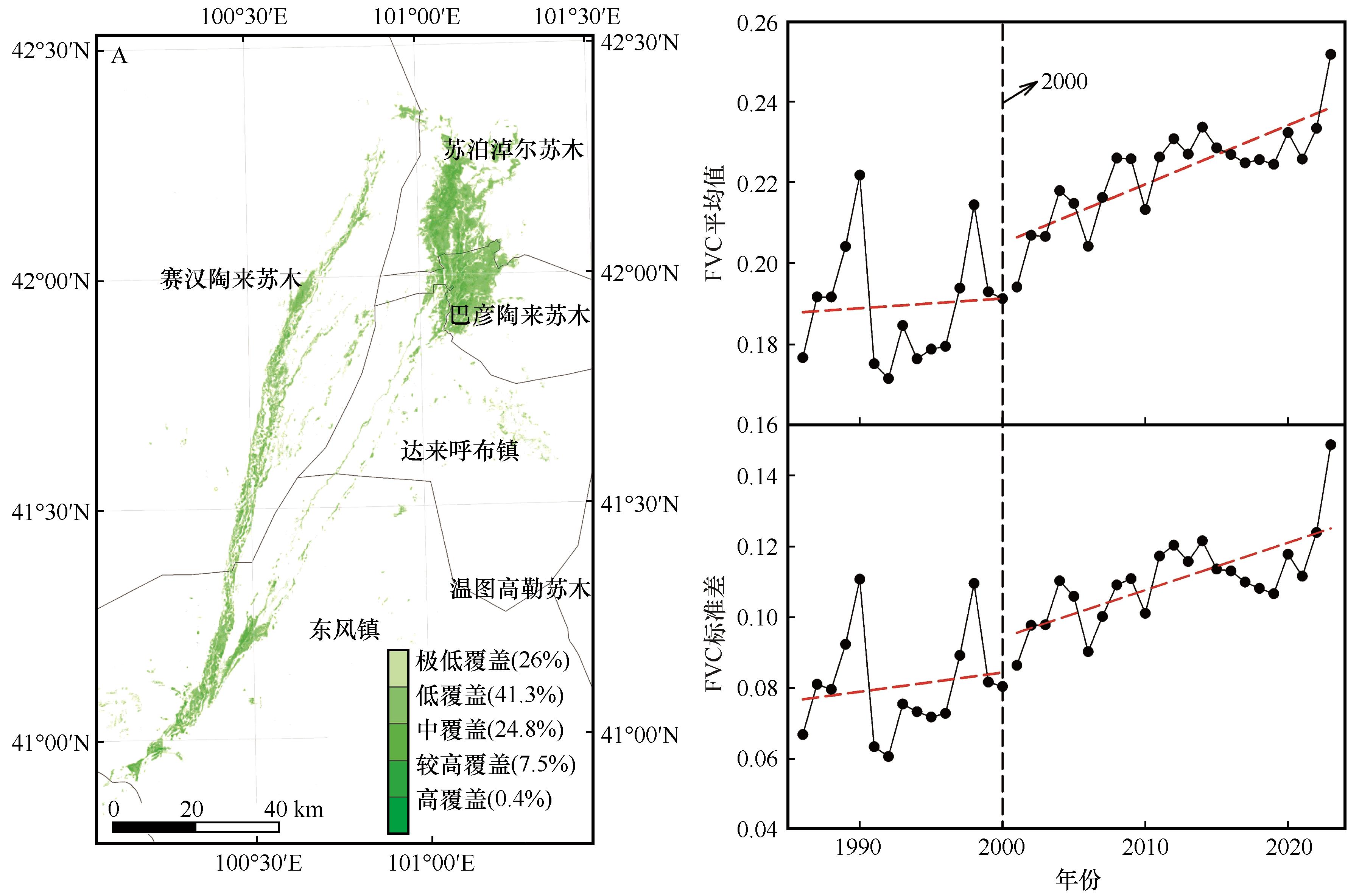
Chen J J, Yi S H, Qin Y,et al.Improving estimates of fractional vegetation cover based on UAV in alpine grassland on the Qinghai-Tibetan Plateau[J].International Journal of Remote Sensing,2016,37(8):1922-1936.
|
| 12 |
Kellner J R, Armston J, Birrer M,et al.New opportunities for forest remote sensing through ultra-high-density drone lidar[J].Surveys in Geophysics,2019,40:959-977.
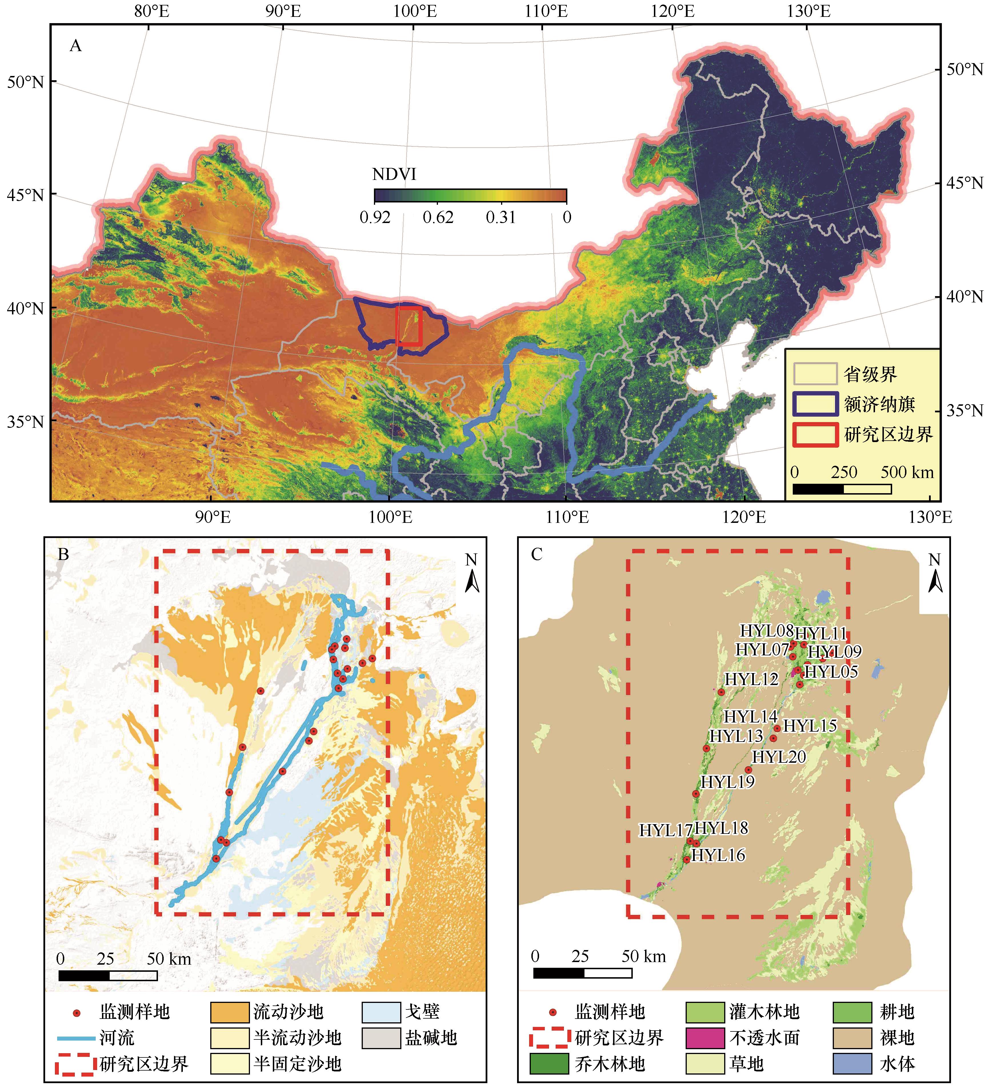
|
| 13 |
Ma Q, Su Y J, Guo Q H.Comparison of canopy cover estimations from airborne LiDAR,aerial imagery,and satellite imagery[J].IEEE Journal of Selected Topics in Applied Earth Observations and Remote Sensing,2017,10(9):4225-4236.
|
| 14 |
Wasser L, Chasmer L, Day R,et al.Quantifying land use effects on forested riparian buffer vegetation structure using LiDAR data[J].Ecosphere,2015,6(1):1-17.
|
| 15 |
王泽华,甘淑,吕杰,等.泥石流沟谷地形的机载激光雷达点云滤波算法对比[J].兰州大学学报(自然科学版),2023,59(6):770-777.
|
| 16 |
刘兵兵,魏建新,胡天宇,等.卫星遥感监测产品在中国森林生态系统的验证和不确定性分析:基于海量无人机激光雷达数据[J].植物生态学报,2022,46(10):1305-1316.
|
| 17 |
苏阳,祁元,王建华,等.基于LiDAR数据的额济纳绿洲胡杨(Populus euphratica)河岸林植被覆盖分类与植被结构参数提取[J].中国沙漠,2017,37(4):689-697.
|
| 18 |
张亦然,刘廷玺,童新,等.基于多源遥感和机器学习方法的科尔沁沙地植被覆盖度反演[J].中国沙漠,2022,42(3):187-195.
|
| 19 |
Riihimäki H, Luoto M, Heiskanen J.Estimating fractional cover of tundra vegetation at multiple scales using unmanned aerial systems and optical satellite data[J].Remote Sensing of Environment,2019,224:119-132.
|
| 20 |
Wu S, Deng L, Zhai J,et al.Approach for monitoring spatiotemporal changes in fractional vegetation cover through unmanned aerial system-guided-satellite survey:a case study in mining area[J].IEEE Journal of Selected Topics in Applied Earth Observations and Remote Sensing,2023,16:5502-5513.
|
| 21 |
Yu T F, Feng Q, Si J H,et al.Responses of riparian forests to flood irrigation in the hyper-arid zone of NW China[J].Science of the Total Environment,2019,648:1421-1430.
|
| 22 |
Zhao X Q, Guo Q H, Su Y J,et al.Improved progressive TIN densification filtering algorithm for airborne LiDAR data in forested areas[J].ISPRS Journal of Photogrammetry and Remote Sensing,2016,117:79-91.
|
| 23 |
Wang X, Biederman J A, Knowles J F,et al.Satellite solar-induced chlorophyll fluorescence and near-infrared reflectance capture complementary aspects of dryland vegetation productivity dynamics[J].Remote Sensing of Environment,2022,270:112858.
|
| 24 |
Huete A R.A soil-adjusted vegetation index (SAVI)[J].Remote Sensing of Environment,1988,25(3):295-309.
|
| 25 |
Liu N F, Treitz P.Modelling high arctic percent vegetation cover using field digital images and high resolution satellite data[J].International Journal of Applied Earth Observation and Geoinformation,2016,52:445-456.
|
| 26 |
Alvarez-Vanhard E, Houet T, Mony C,et al.Can UAVs fill the gap between in situ surveys and satellites for habitat mapping?[J].Remote Sensing of Environment,2020,243:111780.
|
| 27 |
刘洋.无人机LiDAR角度效应对估测森林结构参数的影响[D].呼和浩特:内蒙古师范大学,2023.
|
| 28 |
陈成,杨栋淏,王建雄,等.滇西南植被覆盖度动态变化特征及其驱动力分析[J].水土保持研究,2022,29(4):198-206.
|
| 29 |
Chiesi M, Angeli L, Battista P,et al.Monitoring and analysis of crop irrigation dynamics in Central Italy through the use of MODIS NDVI data[J].European Journal of Remote Sensing,2022,55(1):23-36.
|
| 30 |
周红敏,张国东,王昶景,等.塞罕坝地区高空间分辨率叶面积指数时序估算与变化检测[J].遥感学报,2021,25(4):1000-1012.
|
| 31 |
赵晨光,程业森,李慧瑛,等.腾格里沙漠东北缘人工植被恢复区土地利用/覆被变化及其驱动因素分析[J].干旱区资源与环境,2021,35(6):131-138.
|
| 32 |
陈艳锋,杨美琳,陈军纪,等.基于植被指数极旱荒漠区生物量模型研究:以安西极旱荒漠保护区北片为例[J].干旱区资源与环境,2015,29(10):93-99.
|
| 33 |
Yan F, Wu B, Wang Y J.Estimating aboveground biomass in Mu Us Sandy Land using Landsat spectral derived vegetation indices over the past 30 years[J].Journal of Arid Land,2013,5:521-530.
|
| 34 |
韩子言,蒙吉军,邹易,等.1982-2017年黑河流域植被指数动态及其对气候变化与生态建设工程的响应[J].中国沙漠,2023,43(3):96-106.
|
| 35 |
高冠龙,张小由,鱼腾飞,等.1987-2008年额济纳绿洲土地覆被变化及其驱动机制[J].中国沙漠,2015,35(3):821-829.
|
| 36 |
胡洁,姜成桢,杨勇,等.黑河中下游植被覆盖度变化遥感监测[J].测绘通报,2021(10):34-38.
|
| 37 |
王川,张勇勇,赵文智,等.黑河下游额济纳绿洲近二十年生态输水的生态水文恢复效应[J].生态学杂志,2022,41(11):2180-2187.
|
 ), 党国锋1, 鱼腾飞2,3(

 甘公网安备 62010202000688号