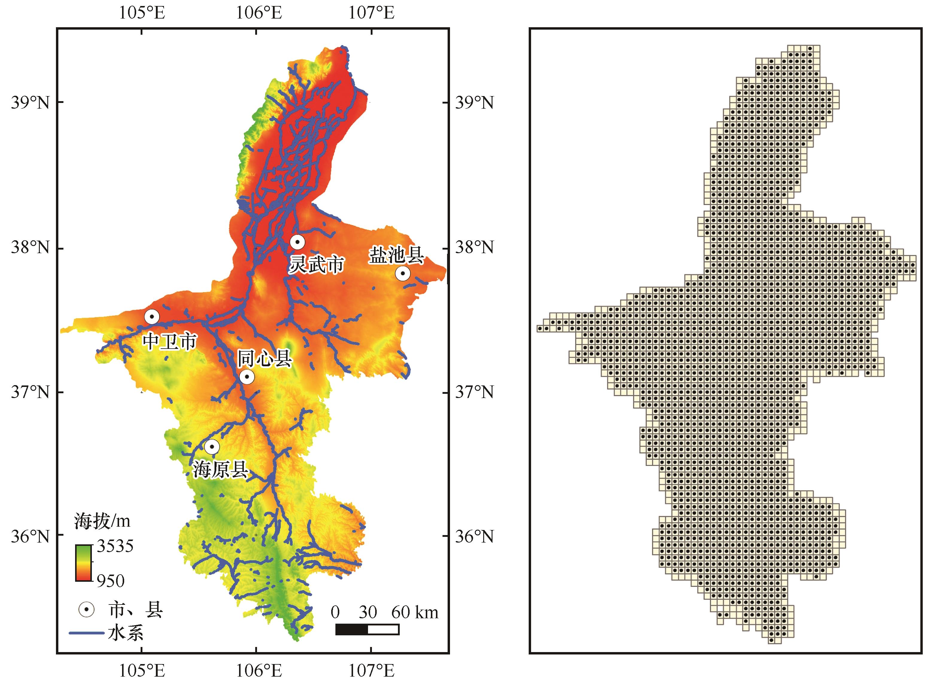
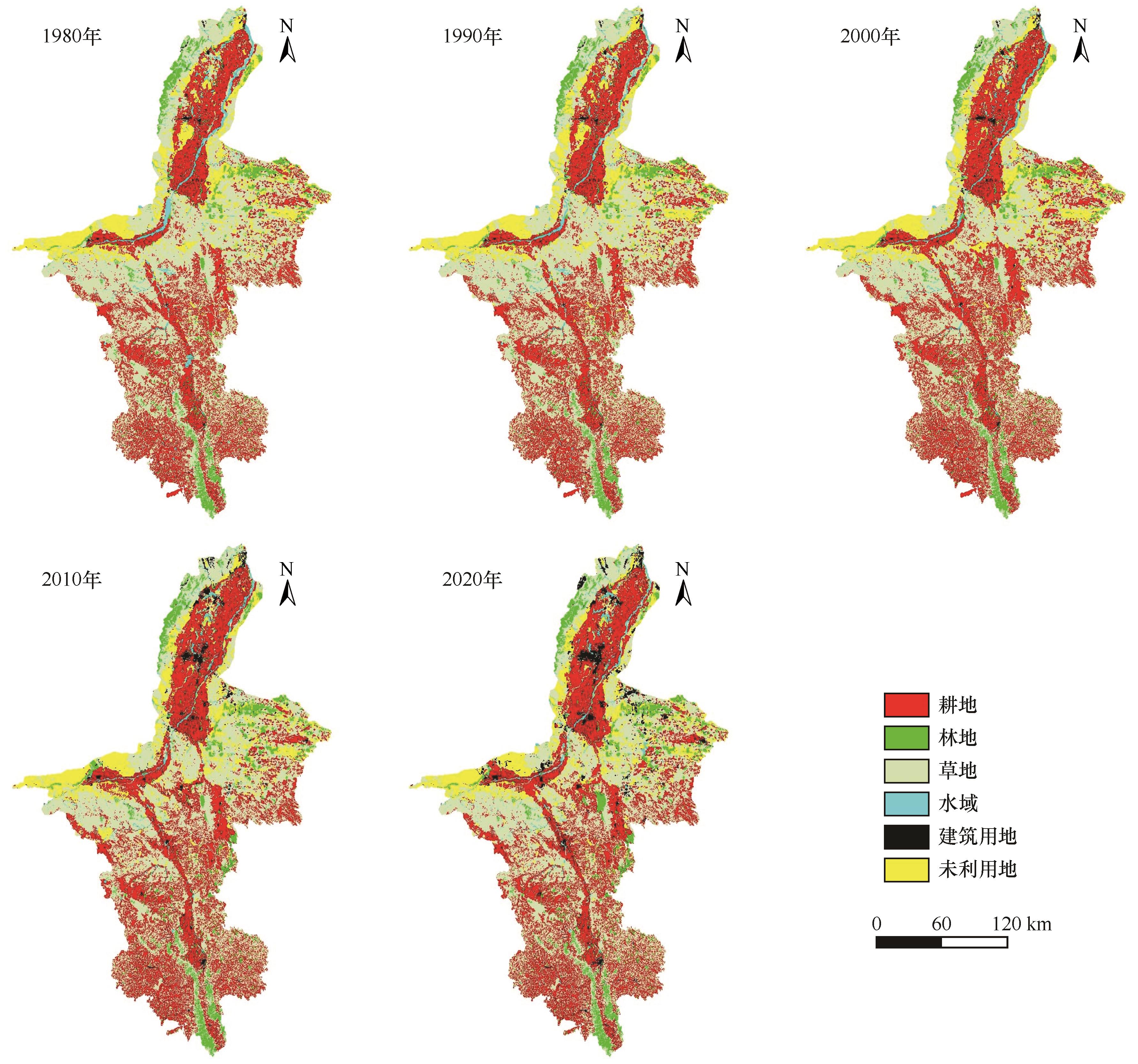
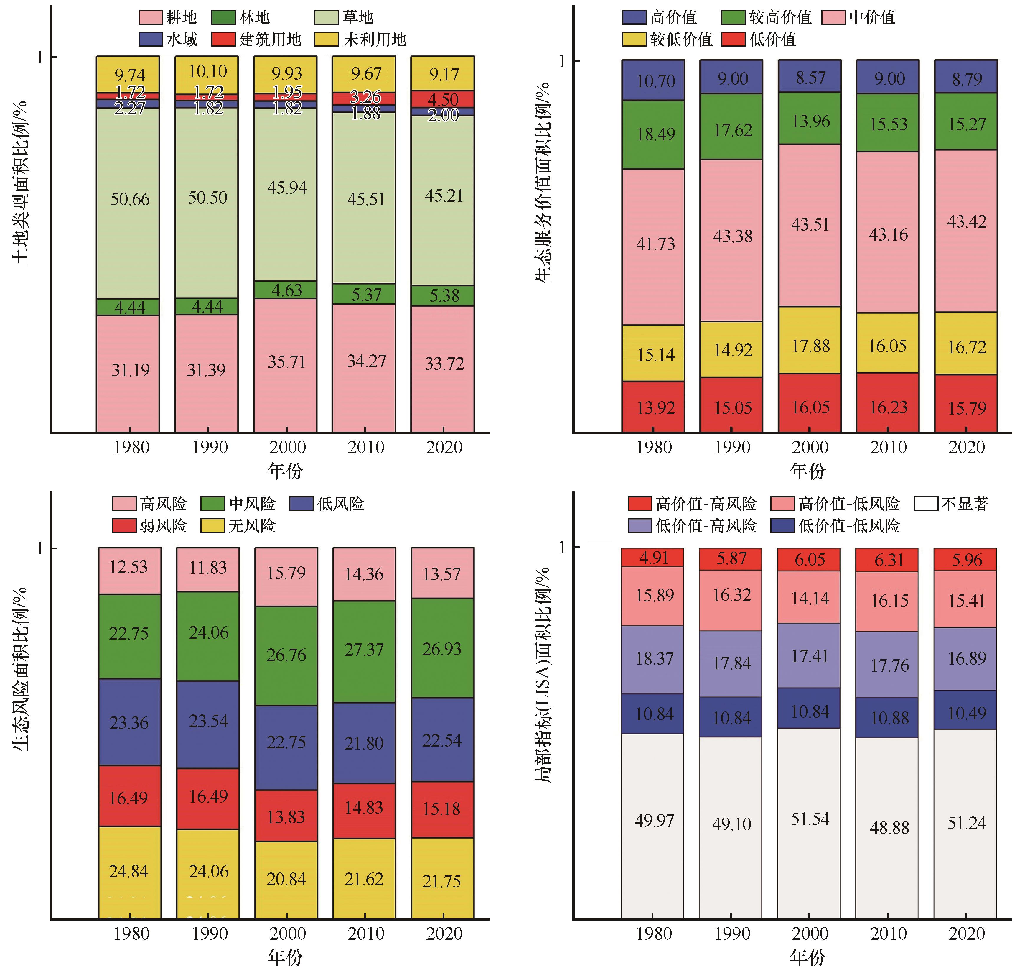
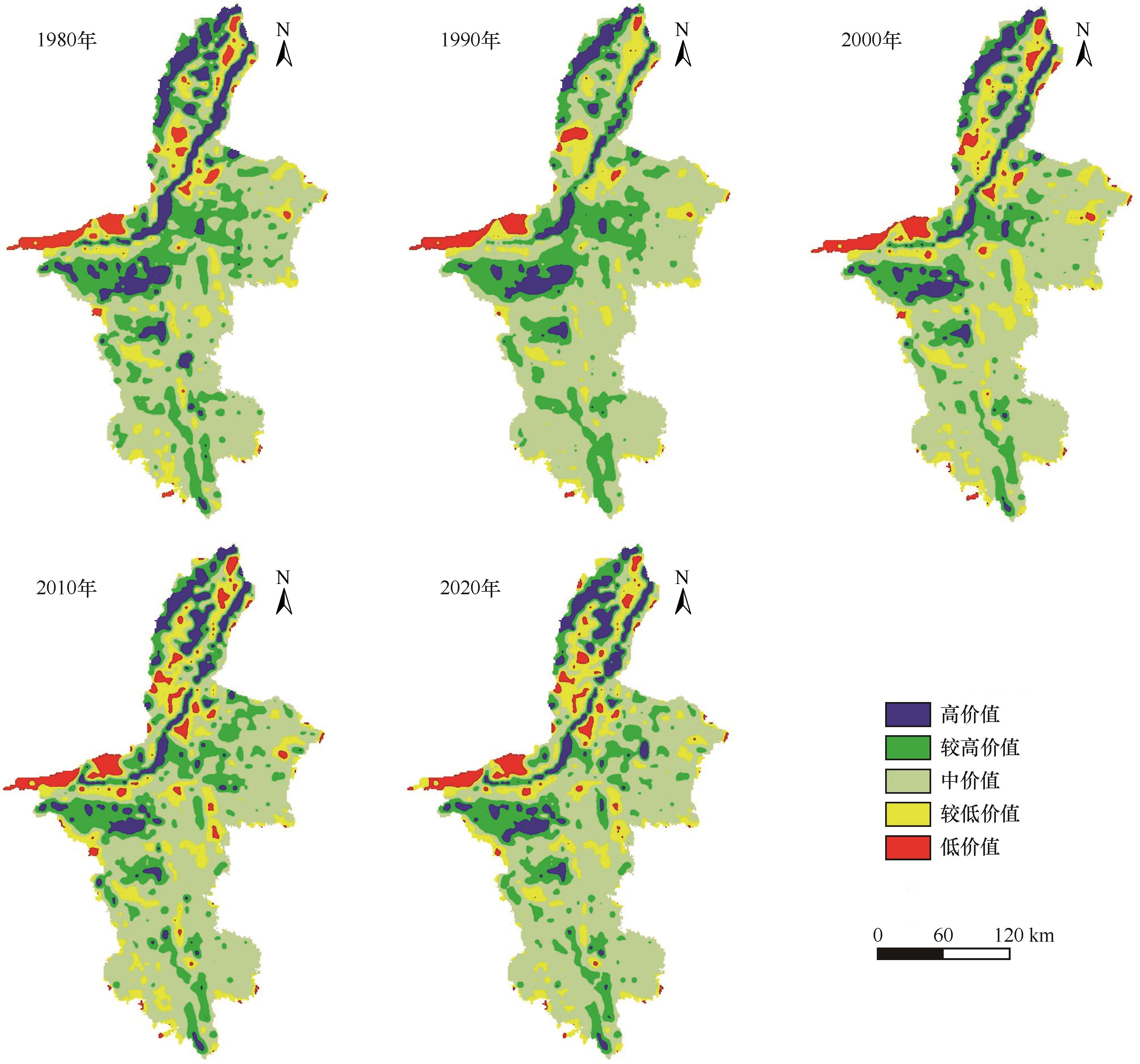
| 1 |
张卫红,谢家丽,刘志鹏,等.2000-2020年宁夏生态系统服务价值变化[J].中国沙漠,2023,43(4):157-167.
|
| 2 |
王耀宗,岳新斌,谢家丽,等.2000-2020年宁夏河东沙区沙漠化演变[J].中国沙漠,2023,43(4):31-40.
|
| 3 |
杨强强,章翩,邱小琮,等.宁夏回族自治区生态系统服务时空变化及其权衡研究[J].中国环境科学,2023,43(10):5453-5465.
|
| 4 |
曹婧昳.干旱半干旱区生态系统服务时空变化特征及驱动力研究:以宁夏回族自治区为例[D].南昌:江西财经大学,2023.
|
| 5 |
林达义.宁夏回族自治区生态系统服务时空格局及其权衡协同关系研究[D].北京:中国环境科学研究院,2022.
|
| 6 |
程静,黄越.宁夏回族自治区生态系统服务价值时空演变及其驱动力[J].水土保持研究,2021,28(2):382-389.
|
| 7 |
王磊,郭灿,李慧明.基于PSR-TOPSIS模型的宁夏回族自治区土地生态安全评价[J].水土保持研究,2016,23(6):154-159.
|
| 8 |
丁彩霞,延军平.基于PSR模型的宁夏地区生态环境变化特征研究[J].水土保持通报,2015,35(3):191-196.
|
| 9 |
潘玉豪,陈云皓,张旭晨,等.宁夏土地荒漠化敏感度时空变化分析[J].北京师范大学学报(自然科学版),2020,56(4):582-590.
|
| 10 |
吴强强.宁夏限制开发生态区土地利用与生态环境耦合协调关系测度[D].银川:宁夏大学,2018.
|
| 11 |
贾艳艳,唐晓岚,任宇杰.长江流域安徽段生态系统服务价值与景观生态风险时空演变及其关联分析[J].南京林业大学学报(自然科学版),2022(3):31-40.
|
| 12 |
孙天弘,雷平.国内土地利用生态风险研究进展[J].资源与产业,2019,21(1):95-104.
|
| 13 |
Liu F L, Yang L, Wang S.Spatial and temporal evolution and correlation analysis of landscape ecological risks and ecosystem service values in the Jinsha River Basin[J].Journal of Resources and Ecology,2023,14(5):914-927.
|
| 14 |
Liang X Y, Wu F D, Wu J Z,et al.Construction of ecological corridors in karst areas based on ecological sensitivity and ecological service value[J].Land,2023,12(6):1-10.
|
| 15 |
Yongge L, Wei L, Qi F,et al.Spatiotemporal dynamics and driving factors of ecosystem services value in the Hexi regions, Northwest China[J].Sustainability,2022,14(21):1-10.
|
| 16 |
Daily G C.Nature's Services:Societal Dependence on Natural Ecosystems[M].Washington DC,USA:Island Press,1997.
|
| 17 |
Costanza R,D'arger, de GrooT R,et al.The value of the world's ecosystem services and natural capita[J].Nature,1997,387(15):253-260.
|
| 18 |
郭宗亮,刘亚楠,张璐,等.生态系统服务研究进展与展望[J].环境工程技术学报,2022,12(3):928-936.
|
| 19 |
张莉金,白羽萍,胡业翠,等.不同SSP-RCP情景下中国生态系统服务价值评估[J].生态学报,2023,43(2):510-521.
|
| 20 |
陈芳淼,黄慧萍,杨光,等.基于遥感生态指数的黄河流域生态环境质量变化及影响因素分析[J].中国沙漠,2023,43(4):252-262.
|
| 21 |
张学斌,石培基,罗君,等.基于景观格局的干旱内陆河流域生态风险分析:以石羊河流域为例[J].自然资源学报,2014,29(3):410-419.
|
| 22 |
彭建,党威雄,刘焱序,等.景观生态风险评价研究进展与展望[J].地理学报,2015,70(4):664-677.
|
| 23 |
陈峰,李红波,张安录.基于生态系统服务的中国陆地生态风险评价[J].地理学报,2019,74(3):432-445.
|
| 24 |
Gong J, Cao E J, Xie Y C,et al.Integrating ecosystem services and landscape ecological risk into adaptive management:insights from a western mountain-basin area,China[J].Journal of Environmental Management,2020,281:111817.
|
| 25 |
Liao J F, Jia Y Q, Tang L N,et al.Assessment of urbanization-induced ecological risks in an area with significant ecosystem services based on land use/cover change scenarios[J].International Journal of Sustainable Development and World Ecology,2018,25(5):448-457.
|
| 26 |
Xing L, Hu M S, Wang Y.Integrating ecosystem servicesvalue and uncertainty into regional ecological riskassessment:a case study of Hubei Province,Central China[J].Science of the Total Environment,2020,740:140126.
|
| 27 |
李俊翰,高明秀.滨州市生态系统服务价值与生态风险时空演变及其关联性[J].生态学报,2019,39(21):7815-7828.
|
| 28 |
李辉,周启刚,李斌,等.近30年三峡库区生态系统服务价值与生态风险时空变化及相关性研究[J].长江流域资源与环境,2021,30(3):654-666.
|
| 29 |
靳甜甜,张云霞,朱月华,等.黄土高原林区生态系统服务价值与景观生态风险时空变化及其关联性:以子午岭区为例[J].应用生态学报,2021,32(5):1623-1632.
|
| 30 |
蒋伟峰,许艳,李冬花,等.流域生态系统服务价值、生态风险过程及其关联性:以淮河流域安徽段为例[J]. 水土保持通报,2022,42(3):120-130.
|
| 31 |
徐乙文,戴文远,黄万里,等.福州中心城区生态服务价值与景观生态风险时空变化及相关性分析[J].生态科学,2021,40(4):92-101.
|
| 32 |
周建伟,罗君.干旱河谷生态服务价值与景观生态风险时空演变[J].人民长江,2023,54(4):85-93.
|
| 33 |
夏照亮. 红水河流域贵州段景观生态风险与生态系统服务价值时空演变及生态空间分区研究[D].贵阳:贵州师范大学,2023.
|
| 34 |
易秋松. 吉安市生态系统服务功能与景观生态风险关联性及空间对策研究[D].南昌:江西财经大学,2022.
|
| 35 |
陈红翔,王炳莹.宁夏主要粮食作物种植结构的时空变化特征[J].江西农业学报,2022,34(12):171-181.
|
| 36 |
谢高地,张彩霞,张雷明,等.基于单位面积价值当量因子的生态系统服务价值化方法改进[J].自然资源学报,2015,30(8):1243-1254.
|
| 37 |
谢高地,甄霖,鲁春霞,等.一个基于专家知识的生态系统服务价值化方法[J].自然资源学报,2008,23(5):911-919.
|
| 38 |
Souris M, Bichaud L.Statistical methods for bivariate spatial analysis in marked points.examples in spatial epidemiology[J].Spatial and Spatio-Temporal Epidemiology,2011,2(4):227-234.
|
| 39 |
Piet G J, Knights A M, Jongbloed R H,et al.Ecological risk assessments to guide decision-making:methodology matters[J].Environmental Science & Policy,2017,68:1-9.
|
| 40 |
郑雪慧,杨志,任正龑,等.基于GIS的宁夏土壤侵蚀敏感性与景观生态风险评价[J].水土保持研究,2022,29(6):8-20.
|
| 41 |
宋小龙,米文宝,李陇堂,等.宁夏旅游经济与生态环境耦合协调过程与格局[J].中国沙漠,2021,41(5):1-10.
|
| 42 |
李娜,高晓清,杨发奎,等.主体功能区划背景下的宁夏生态文明建设[J].中国沙漠,2019,39(1):12-17.
|
| 43 |
陆媛媛,刘超,曾克峰,等.宁夏城市化与生态环境的耦合关系[J].中国沙漠,2016,36(4):1198-1206.
|
 ), 刘冰1,3(


 甘公网安备 62010202000688号