| 1 |
刘媖心.中国沙漠植物志[M].北京:科学出版社,1985.
|
| 2 |
张奕,肖辉杰,辛智鸣,等.乌兰布和沙区典型灌木防风阻沙效益[J].中国水土保持科学(中英文),2021,19(1):87-96.
|
| 3 |
李映坤,李锦荣,董雷,等.乌兰布和沙漠周边典型植物群落防风阻沙效果[J].中国沙漠,2022,42(6):65-73.
|
| 4 |
Búrquez A, Martínez-Yrízar A, Núñez S,et al.Aboveground biomass in three Sonoran Desert communities:variability within and among sites using replicated plot harvesting[J].Journal of Arid Environments,2010,74(10):1240-1247.
|
| 5 |
Houghton A R, Forrest H, Goetz S J.Importance of biomass in the global carbon cycle[J].Journal of Geophysical Research.Biogeosciences,2011,116(G2):G00E03.
|
| 6 |
Houghton R A.Aboveground forest biomass and the global carbon balance[J].Global Change Biology,2005,11(6):945-958.
|
| 7 |
Dixon R K, Solomon A M, Brown S,et al.Carbon pools and flux of global forest ecosystems[J].Science,1994,263(5144):185-190.
|
| 8 |
赵学勇,安沙舟,曹广民,等.中国荒漠主要植物群落调查的意义、现状及方案[J].中国沙漠,2023,43(1):9-19.
|
| 9 |
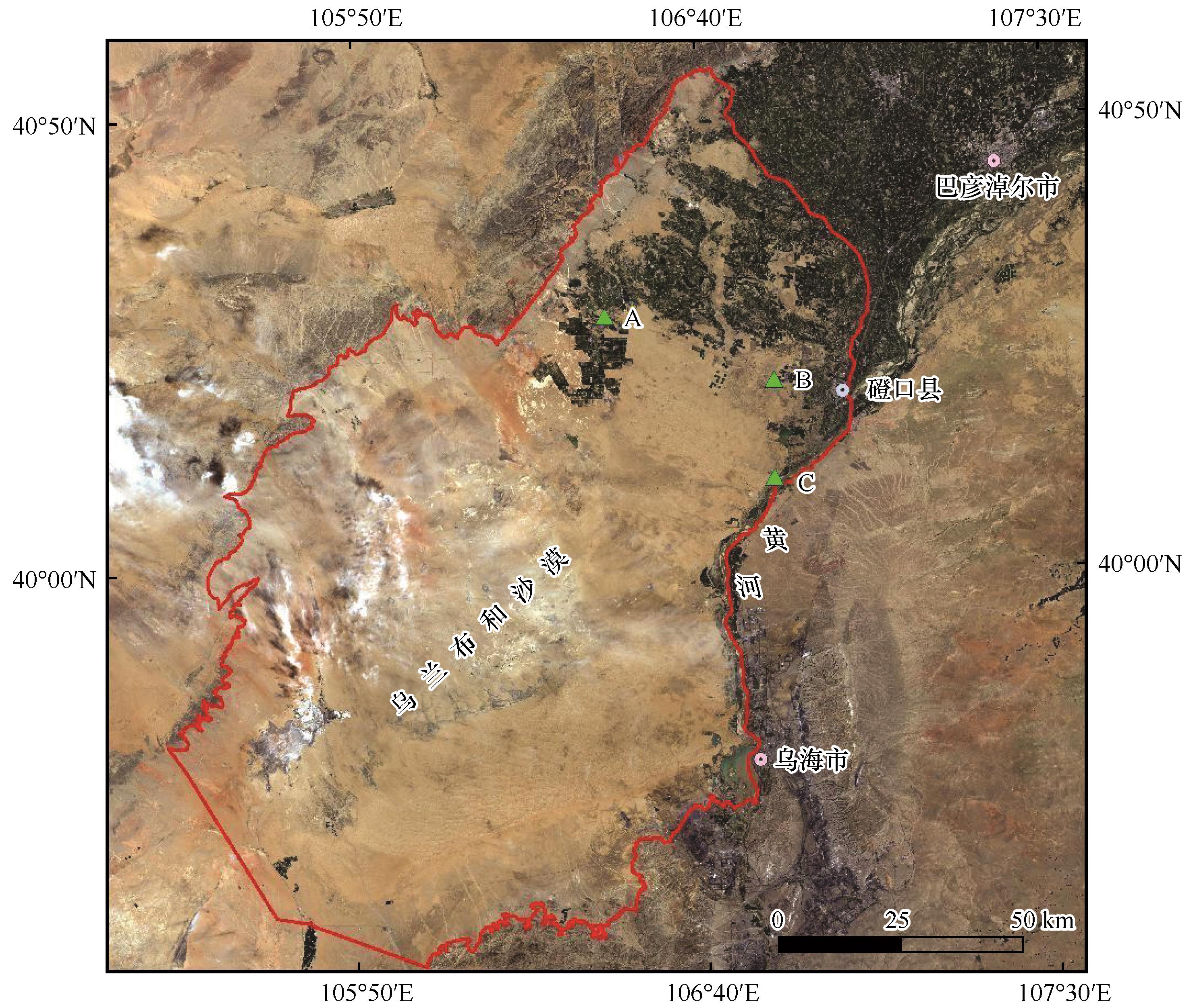
党晓宏,高永,蒙仲举,等.西鄂尔多斯荒漠灌丛生态系统碳密度[J].中国沙漠,2018,38(2):352-362.
|
| 10 |
卢振龙,龚孝生.灌木生物量测定的研究进展[J].林业调查规划,2009,34(4):37-40.
|
| 11 |
刘婵,赵文智,刘冰,等.基于无人机和MODIS数据的巴丹吉林沙漠植被分布特征与动态变化研究[J].中国沙漠,2019,39(4):92-102.
|
| 12 |
Bryson M, Reid A, Ramos F,et al.Airborne vision-based mapping and classification of large farmland environments[J].Journal of Field Robotics,2010,27(5):632-655.
|
| 13 |
Hill R A, Wilson A K, George M,et al.Mapping tree species in temperate deciduous woodland using time-series multi-spectral data[J].Applied Vegetation Science,2010,13(1):86-99.
|
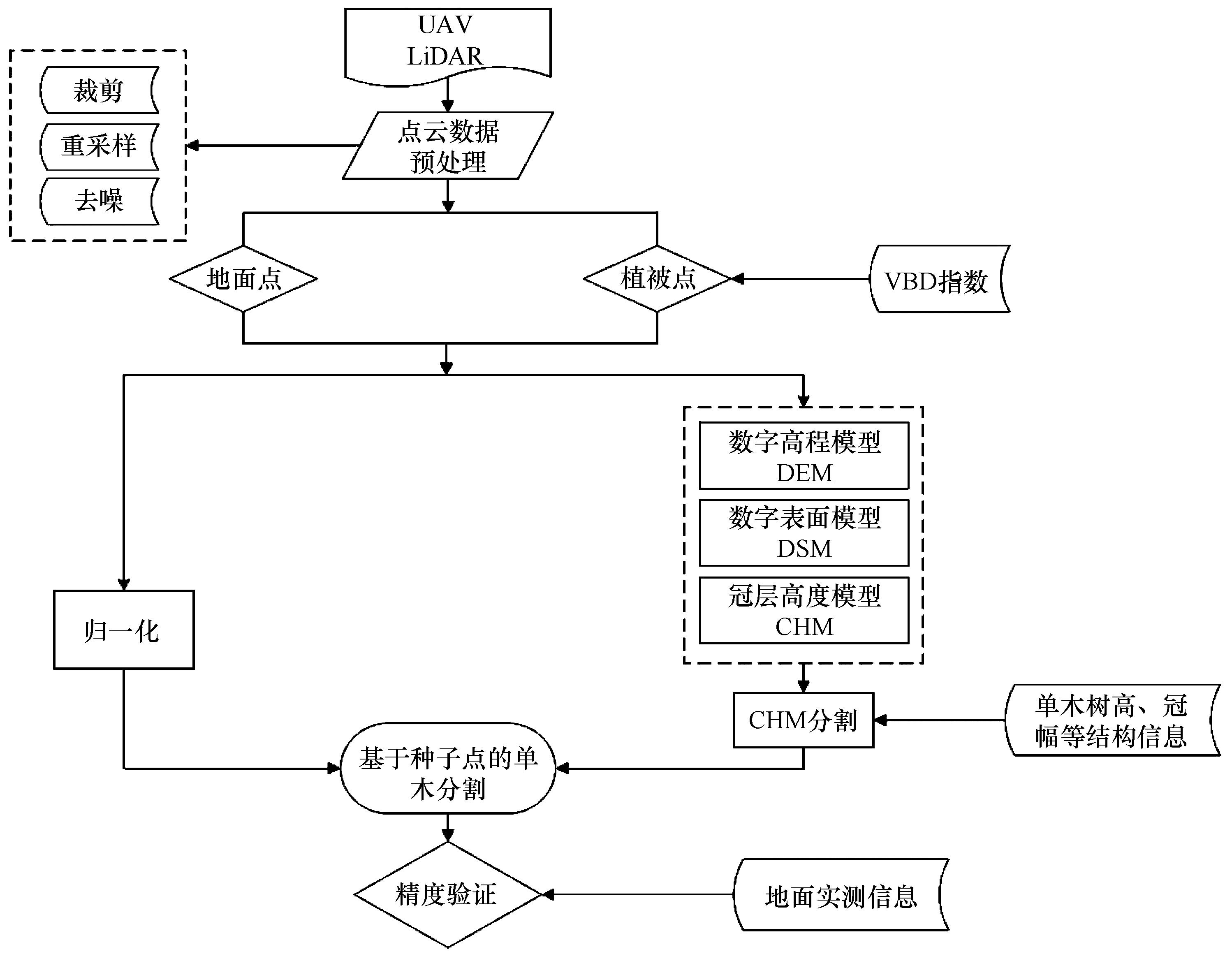
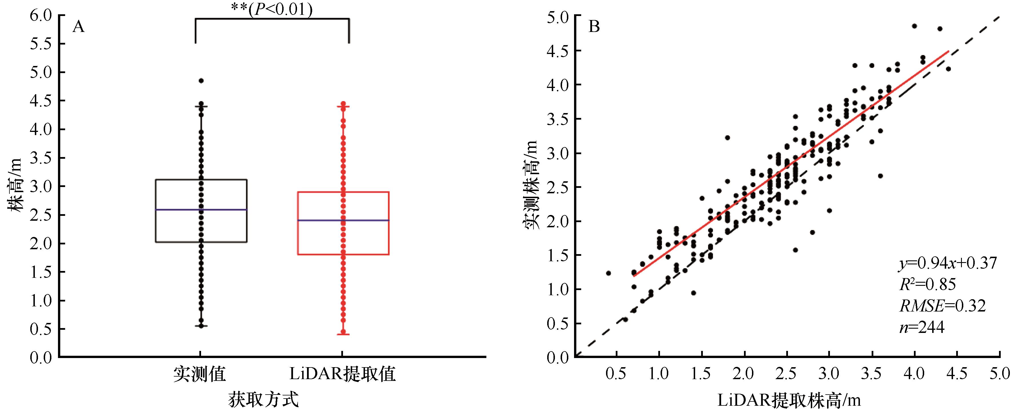
| 14 |
Zhao B, Yan Y, Guo H,et al.Monitoring rapid vegetation succession in estuarine wetland using time series MODIS-based indicators:an application in the Yangtze River Delta area[J].Ecological Indicators,2008,9(2):346-356.
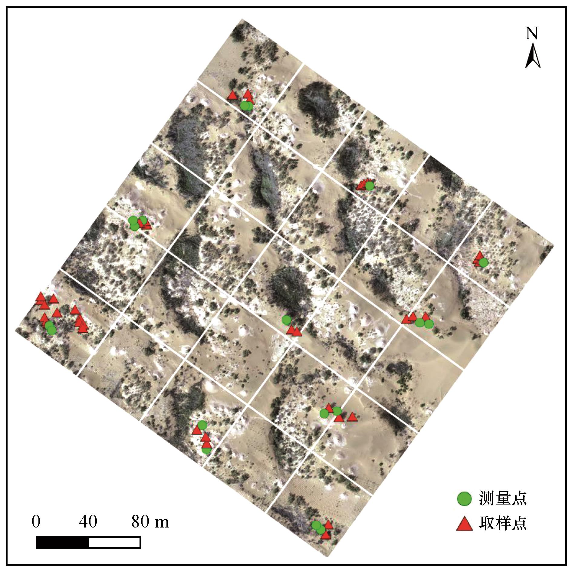
|
| 15 |
Torres-Sánchez J, Peña J M, de Castro A I,et al.Multi-temporal mapping of the vegetation fraction in early-season wheat fields using images from UAV[J].Computers and Electronics in Agriculture,2014,103:104-113.
|
| 16 |
Boschetti M, Boschetti L, Oliveri S,et al.Tree species mapping with airborne hyper-spectral MIVIS data:the Ticino Park study case[J].International Journal of Remote Sensing,2007,28(6):1251-1261.
|
| 17 |
王震,褚桂坤,张宏建,等.基于无人机可见光图像Haar-like特征的水稻病害白穂识别[J].农业工程学报,2018,34(20):73-82.
|
| 18 |
de Jesús Návar Cháidez J.Allometric equations and expansion factors for tropical dry forest trees of eastern Sinaloa,Mexico[J].Tropical and Subtropical Agroecosystems,2008,10(1):45-52.
|
| 19 |
Myneni R B, Dong J, Tucker C J,et al.A large carbon sink in the woody biomass of Northern forests[J].Proceedings of the National Academy of Sciences of the United States of America,2001,98(26):14784-14789.
|
| 20 |
岳喜元,常学礼,刘良旭,等.科尔沁沙地几种固沙植物光谱-生物量模型构建与分析[J].中国沙漠,2014,34(6):1496-1502.
|
| 21 |
Duncanson L I, Niemann K O, Wulder M A.Integration of GLAS and Landsat TM data for aboveground biomass estimation[J].Canadian Journal of Remote Sensing,2010,36(2):129-141.
|
| 22 |
Gibbs H K, Brown S, Niles J O,et al.Monitoring and estimating tropical forest carbon stocks:making REDD a reality[J].Environmental Research Letters,2007,2(4):45023.
|
| 23 |
Baltsavias E P.Airborne laser scanning:basic relations and formulas[J].ISPRS Journal of Photogrammetry and Remote Sensing,1999,54(2/3):199-214.
|
| 24 |
庞勇,李增元,陈尔学,等.激光雷达技术及其在林业上的应用[J].林业科学,2005(3):129-136.
|
| 25 |
李鹤,丁占良,尤莉,等.乌兰布和沙漠西北缘大型沙波纹的初步研究[J].干旱区资源与环境,2020,34(9):129-136.
|
| 26 |
叶静芸,吴波,刘明虎,等.乌兰布和沙漠东北缘荒漠-绿洲过渡带植被地上生物量估算[J].生态学报,2018,38(4):1216-1225.
|
| 27 |
Zhao X, Guo Q, Su Y,et al.Improved progressive TIN densification filtering algorithm for airborne LiDAR data in forested areas[J].ISPRS Journal of Photogrammetry and Remote Sensing,2016,117:79-91.
|
| 28 |
Khosravipour A, Skidmore A K, Isenburg M.Generating spike-free digital surface models using LiDAR raw point clouds:a new approach for forestry applications[J].International Journal of Applied Earth Observation and Geoinformation,2016,52:104-114.
|
| 29 |
Chen Q, Baldocchi D, Gong P, et al.Isolating individual trees in a savanna woodland using small footprint lidar data.[J].Photogrammetric Engineering & Remote Sensing:Journal of the American Society of Photogrammetry,2006,72(8):923-932.
|
| 30 |
Huete A R.Soil influences in remotely sensed vegeta-tion-canopy spectra[J].Theory and Applications of Optical Remote Sensing,1989,107:107-141.
|
| 31 |
高永刚,林悦欢,温小乐,等.基于无人机影像的可见光波段植被信息识别[J].农业工程学报,2020,36(3):178-189.
|
| 32 |
汪小钦,王苗苗,王绍强,等.基于可见光波段无人机遥感的植被信息提取[J].农业工程学报,2015,31(5):152-157.
|
| 33 |
Gitelson A A, Kaufman Y J, Stark R,et al.Novel algorithms for remote estimation of vegetation fraction[J].Remote Sensing of Environment,2002,80(1):76-87.
|
| 34 |
符利勇,雷渊才,曾伟生.几种相容性生物量模型及估计方法的比较[J].林业科学,2014(6):42-54.
|
| 35 |
Piggot G J.A comparison of four methods for estimating herbage yield of temperate dairy pastures[J].New Zealand Journal of Agricultural Research,2012,32(1):121-123.
|
| 36 |
李晓松,李增元,高志海,等.基于NDVI与偏最小二乘回归的荒漠化地区植被覆盖度高光谱遥感估测[J].中国沙漠,2011,31(1):162-167.
|
| 37 |
王琪,常庆瑞,李铠,等.基于主成分分析和随机森林回归的冬小麦冠层叶绿素含量估算[J/OL].麦类作物学报[2024-02-17]..
|
| 38 |
Wang D, Xin X, Shao Q,et al.Modeling aboveground biomass in Hulunber grassland ecosystem by using unmanned aerial vehicle discrete lidar[J].Sensors,2017,17(1):180.
|
| 39 |
刘清旺,李增元,陈尔学,等.利用机载激光雷达数据提取单株木树高和树冠[J].北京林业大学学报,2008(6):83-89.
|
| 40 |
赵旦.基于激光雷达和高光谱遥感的森林单木关键参数提取[D].北京:中国林业科学研究院,2012.
|
| 41 |
李志杰,黄兵,雷建国.影响机载激光雷达点云密度的因素分析[J].测绘科学,2019,44(6):204-211.
|
| 42 |
Chen Q.Modeling aboveground tree woody biomass using national-scale allometric methods and airborne lidar[J].ISPRS Journal of Photogrammetry and Remote Sensing,2015,106:95-106.
|
| 43 |
Gao Y K, Lu D S, Li G Y,et al.Comparative analysis of modeling algorithms for forest aboveground biomass estimation in a subtropical region[J].Remote Sensing,2018,10(4):627.
|
| 44 |
罗庆辉,徐泽源,许仲林.天山雪岭云杉林生物量估测及空间格局分析[J].生态学报,2020,40(15):5288-5297.
|
| 45 |
雷军,杨逍虎,刘红梅,等.黑河流域中游荒漠典型区域植被生物量及其影响因素[J].中国沙漠,2021,41(1):203-208.
|
| 46 |
Yuan Z, Fang C, Zhang R,et al.Topographic influences on soil properties and aboveground biomass in lucerne-rich vegetation in a semi-arid environment[J].Geoderma,2019,344:137-143.
|
| 47 |
王雪梅,杨雪峰,赵枫,等.基于机器学习算法的干旱区绿洲地上生物量估算[J].生态环境学报,2023,32(6):1007-1015.
|
 ), 李锦荣2(
 甘公网安备 62010202000688号