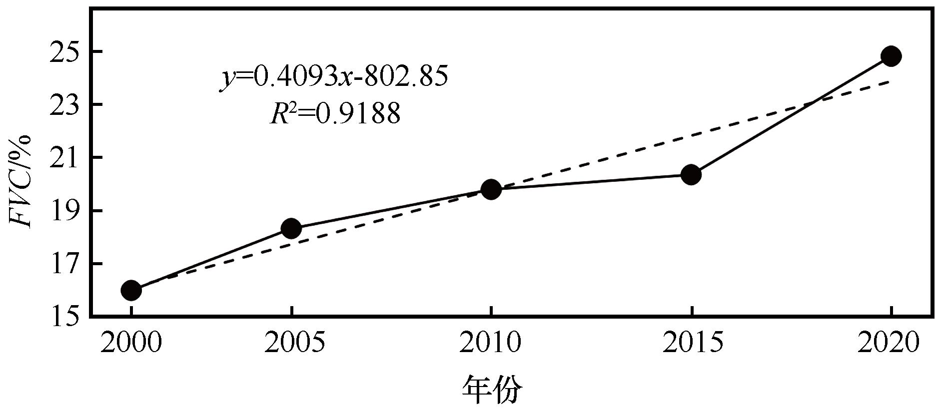
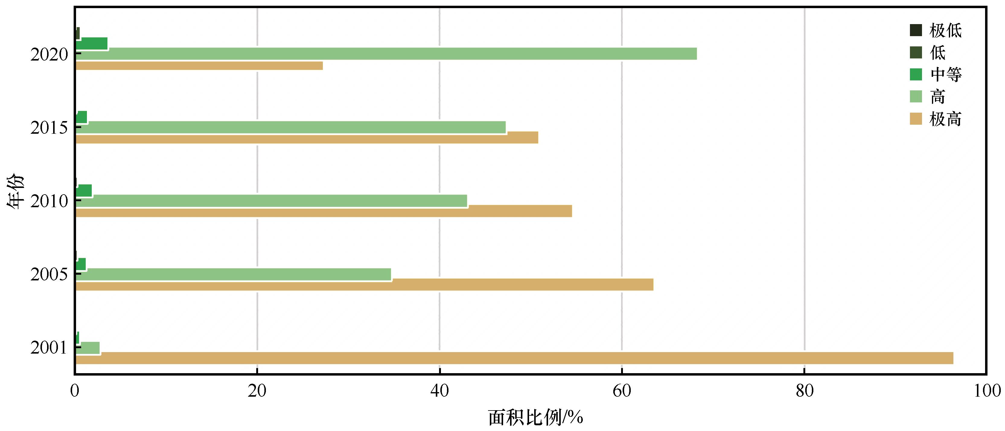
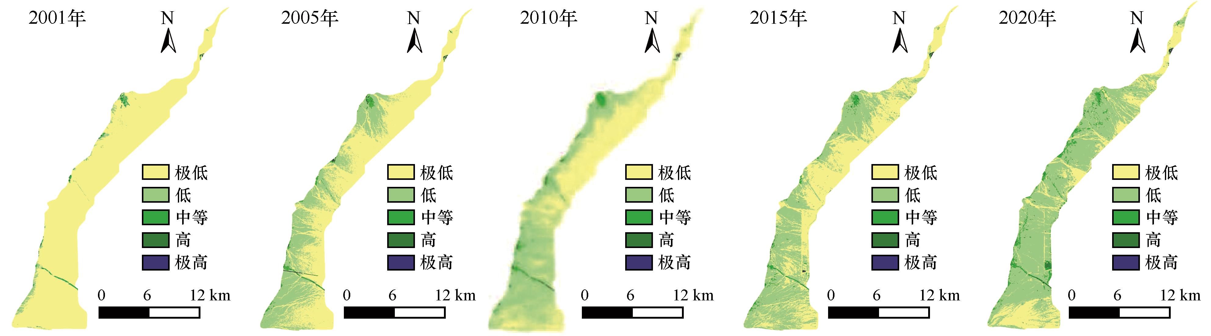
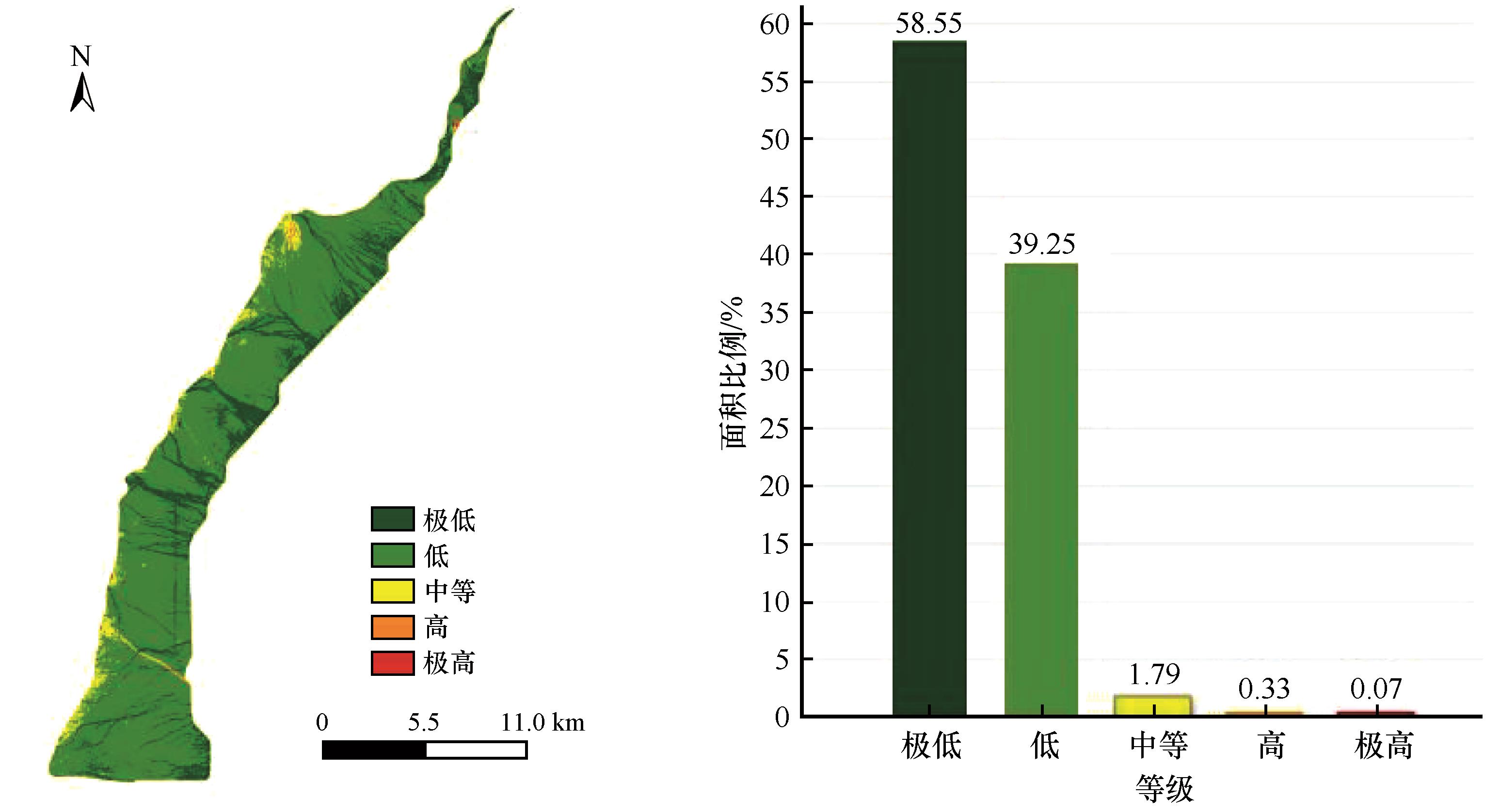
| 1 |
于惠,吴玉锋,金毅,等.河西干旱区植被覆盖度时空格局分析[J].草业科学,2019,36(3):623-631.
|
| 2 |
Gérard P G, Crétaux J F, Michel T,et al.Lake Chad vegetation cover and surface water variations in response to rainfall fluctuations under recent climate conditions (2000-2020)[J].The Science of the Total Environment,2023,857(P2):159302.
|
| 3 |
郑勇,杨武年,刘冲,等.川西高原近20 a植被覆盖变化遥感动态监测及驱动力分析[J].遥感技术与应用,2020,35(6):1447-1456.
|
| 4 |
Wang M, Wang Y, Li Z,et al.Analysis of spatial-temporal changes and driving factors of vegetation coverage in Jiamusi City[J].Forests,2023,14(9):1-15.
|
| 5 |
Lin Y M, Li W H, Nan X X,et al.Spatial-temporal differentiation and driving factors of vegetation coverage in Ningxia Helan Mountain based on geodetector[J].The Journal of Applied Ecology,2022,33(12):3321-3327.
|
| 6 |
林妍敏,李文慧,南雄雄,等.基于地理探测器的宁夏贺兰山植被覆盖度时空分异及驱动因子[J].应用生态学报,2022,33(12):3321-3327.
|
| 7 |
贾一越,齐璇璇,黄蕊,等.山西省植被覆盖度的时空变化及驱动因子[J].应用生态学报,2024,35(1):1-13.
|
| 8 |
黄钰涵,蒋友严,郭天亭,等.甘肃黄土高原植被覆盖时空变化及驱动因素[J].西部资源,2023(6):105-110.
|
| 9 |
王晓蕾,石守海.基于GEE的黄河流域植被时空变化及其地形效应研究[J].地球信息科学学报,2022,24(6):1087-1098.
|
| 10 |
董新明,张亚宁,李生红.贺兰山东麓山前洪积扇不同立地类型造林技术[J].现代农业科技,2013(17):199.
|
| 11 |
梁存柱,朱宗元,李志刚,等.贺兰山植被[M].银川:阳光出版社,2012:142-144.
|
| 12 |
杨瑞瑞,易桂花,张廷斌,等.2000-2015年若尔盖地区植被覆盖度变化及气候因子驱动分析[J].草业科学,2018,35(12):2822-2835.
|
| 13 |
徐建华.计量地理学[M].北京:高等教育出版社,2014.
|
| 14 |
白玛曲西,普布多吉,卓永,等.基于MODIS的横断山区植被时空演变特征及地形效应分析[J].生态与农村环境学报,2023,39(9):1158-1169.
|
| 15 |
Milich L, Weiss E.GAC NDVI interannual coefficient of variation (CoV) images:ground truth sampling of the Sahel along north-south transects[J].International Journal of Remote Sensing,2000,21(2):235-260.
|
| 16 |
Peng H, Wang S, Wang X.Consistency and asymptotic distribution of the Theil-Sen estimator[J].Journal of Statistical Planning and Inference,2007,138(6):1836-1850.
|
| 17 |
Hurst H E.Methods of using long-term storage in reservoirs[J].Proceedings of the Institution of Civil Engineers,1956,5(5):519-543.
|
| 18 |
尹振良,冯起,王凌阁,等.2000-2019年中国西北地区植被覆盖变化及其影响因子[J].中国沙漠,2022,42(4):11-21.
|
| 19 |
刘天弋,孙慧兰,卢宝宝,等.1998-2018年新疆伊犁河谷植被覆盖度时空变化及驱动力[J].东北林业大学学报,2023,51(4):68-74.
|
| 20 |
Li J, Wang J, Zhang J,et al.Growing-season vegetation coverage patterns and driving factors in the China-Myanmar Economic Corridor based on Google Earth Engine and geographic detector[J].Ecological Indicators,2022,136:108620.
|
| 21 |
裴志方,杨武年,吴彬,等.2000-2016年宁夏植被覆盖景观格局遥感动态分析[J].水土保持研究,2018,25(1):215-219.
|
| 22 |
穆少杰,游永亮,朱超,等.中国西北部草地植被降水利用效率的时空格局[J].生态学报,2017,37(5):1458-1471.
|
| 23 |
和海秀,付爱红,王川.塔城地区西北部低山草甸植被指数变化及其驱动力[J].中国沙漠, 2023,43(1):187-196.
|
| 24 |
孙锐,陈少辉,苏红波.2000-2016年黄土高原不同土地覆盖类型植被NDVI时空变化[J].地理科学进展,2019,38(8):1248-1258.
|
| 25 |
李双双,延军平,万佳.近10年陕甘宁黄土高原区植被覆盖时空变化特征[J].地理学报,2012,67(7):960-970.
|
| 26 |
魏乐,宋乃平,方楷.宁夏荒漠草原植物群落的空间异质性[J].草业科学,2014,31(5):826-832.
|
| 27 |
Haibo G, Huiyu L, Xueqiao X,et al.1 km monthly precipitation and temperatures dataset for China from 1952 to 2019 based on new baseline climatology surfaces[J].The Science of the Total Environment,2024,906:167613.1-167613.18.
|
| 28 |
Wang H, Yan S, Liang Z,et al.Strength of association between vegetation greenness and its drivers across China between 1982 and 2015: regional differences and temporal variations[J].Ecological Indicators,2021,128:107831.
|
| 29 |
奎国娴,史常青,杨建英,等.内蒙古草原区植被覆盖度时空演变及其驱动力[J].应用生态学报,2023,34(10):2713-2722.
|
| 30 |
陈亮,王学雷,杨超,等.2000-2018年鄂西山区植被EVI时空变化特征及其地形效应[J].长江流域资源与环境,2021,30(2):419-426.
|
| 31 |
熊俊楠,彭超,程维明,等.基于MODIS-NDVI的云南省植被覆盖度变化分析[J].地球信息科学学报,2018,20(12):1830-1840.
|
| 32 |
张若婧,陈跃红,张晓祥,等.基于参数最优地理探测器的江西省山洪灾害时空格局与驱动力研究[J].地理与地理信息科学,2021,37(4):72-80.
|
| 33 |
Yiming W, Zengxin Z, Xi C.Quantifying influences of natural and anthropogenic factors on vegetation changes based on geodetector:a case study in the Poyang Lake Basin,China[J].Remote Sensing,2021,13(24):5081.
|
| 34 |
韩子言,蒙吉军,邹易,等.1982-2017年黑河流域植被指数动态及其对气候变化与生态建设工程的响应[J].中国沙漠,2023,43(3):96-106.
|
 ), 佘洁2, 石云1,2, 吴涛3, 梁咏亮3, 董军4, 马益婷2


 甘公网安备 62010202000688号