img

官方微信

高级检索

中国沙漠 ›› 2021, Vol. 41 ›› Issue (5): 175-182.DOI: 10.7522/j.issn.1000-694X.2021.00053

• • 上一篇    下一篇

基于地形指数的砒砂岩黄土区土壤侵蚀分析

乔荣荣1(), 韩艳2, 季树新1, 董春媛1, 王傲洁1, 常学礼1()   

  1. 1.鲁东大学 资源与环境工程学院,山东 烟台 264025
    2.潍坊中学,山东 潍坊 261031
  • 收稿日期:2021-03-25 修回日期:2021-04-27 出版日期:2021-09-20 发布日期:2021-09-23
  • 通讯作者: 常学礼
  • 作者简介:常学礼(E-mail: xlchang@126.com
    乔荣荣(1995—),女,山东济宁人,硕士研究生,主要从事区域环境遥感研究。E-mail: rongrongqiao@126.com
  • 基金资助:
    国家自然科学基金项目(41271193);内蒙古自治区“十三五”水利重大专项(NSK2017-M2)

Analysis of soil erosion in loess area of sandstone based on terrain index

Rongrong Qiao1(), Yan Han2, Shuxin Ji1, Chunyuan Dong1, Aojie Wang1, Xueli Chang1()   

  1. 1.School of Resources and Environmental Engineering,Ludong University,Yantai 264025,Shandong,China
    2.Weifang Middle School,Weifang 261031,Shandong,China
  • Received:2021-03-25 Revised:2021-04-27 Online:2021-09-20 Published:2021-09-23
  • Contact: Xueli Chang

摘要:

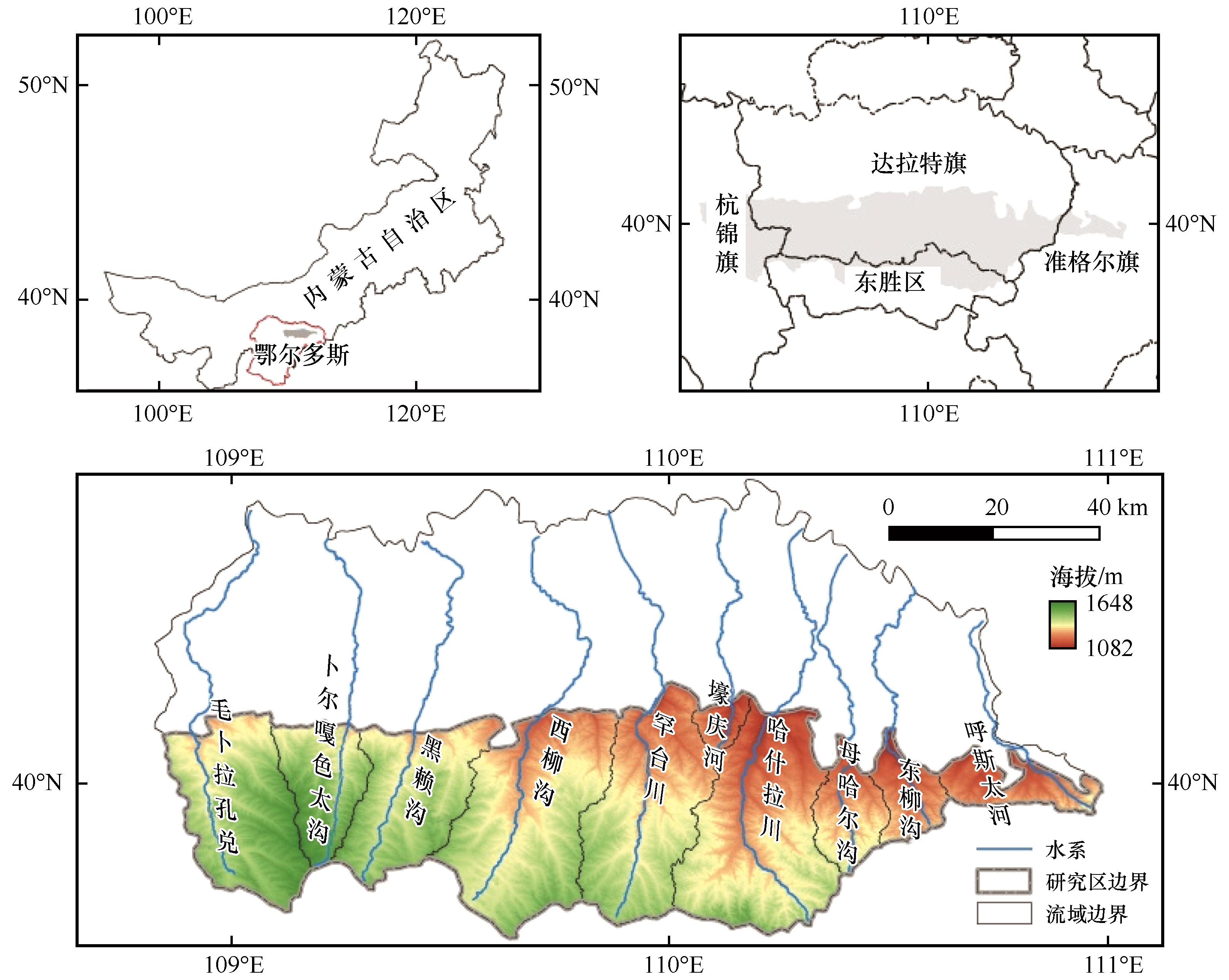
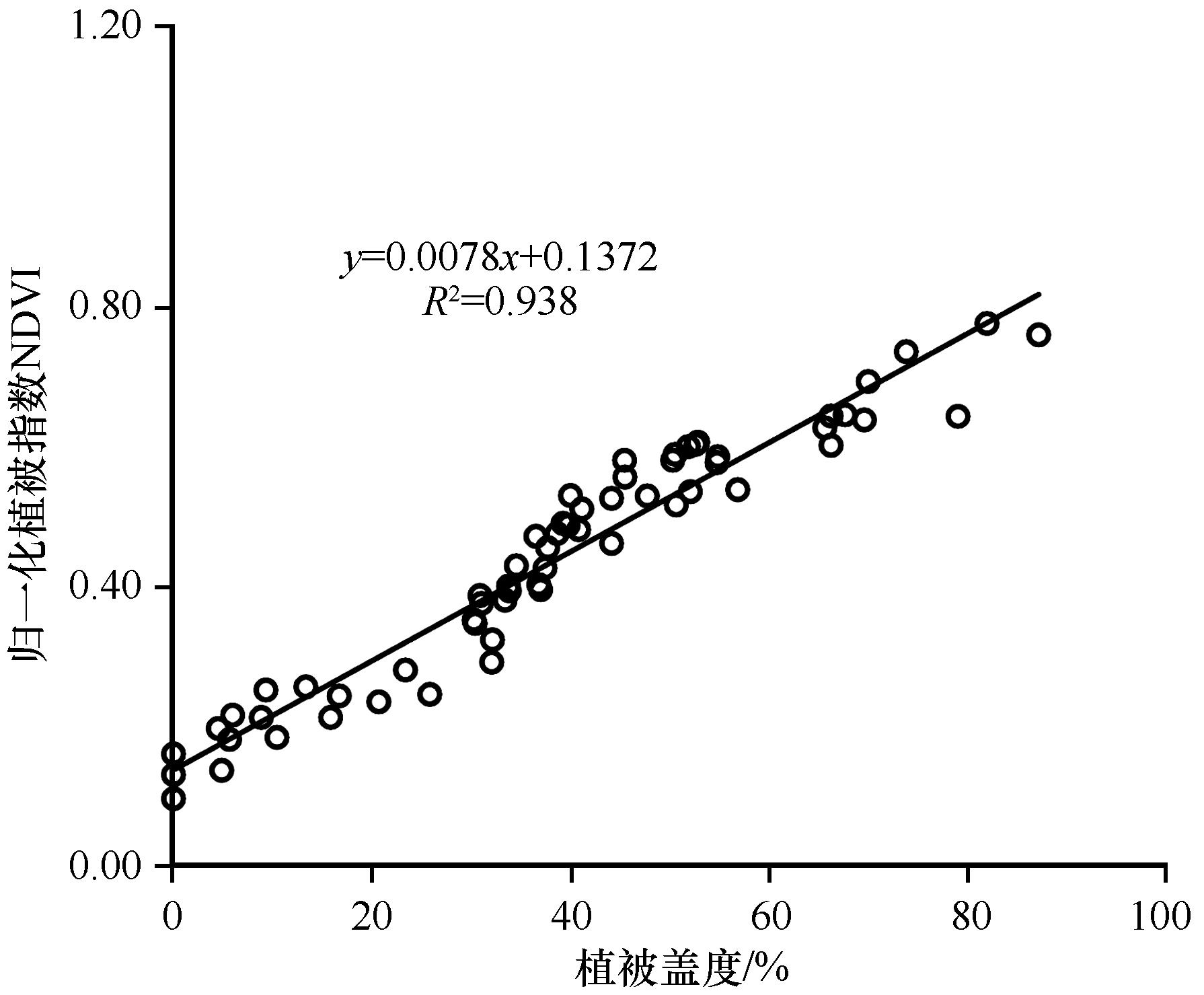
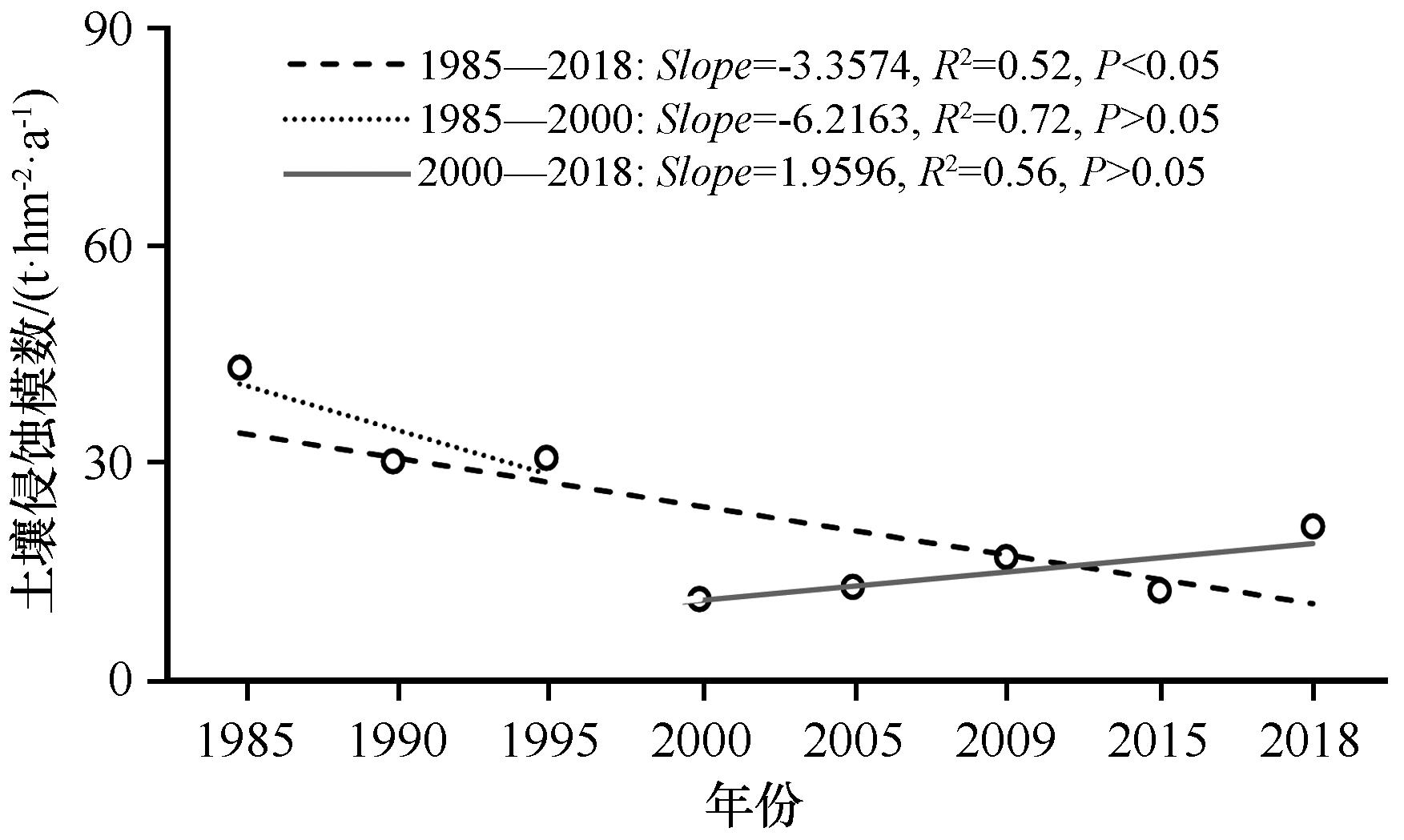
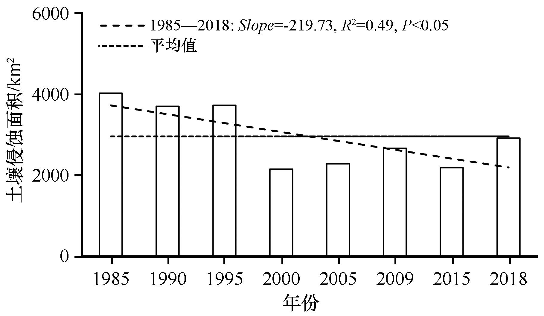
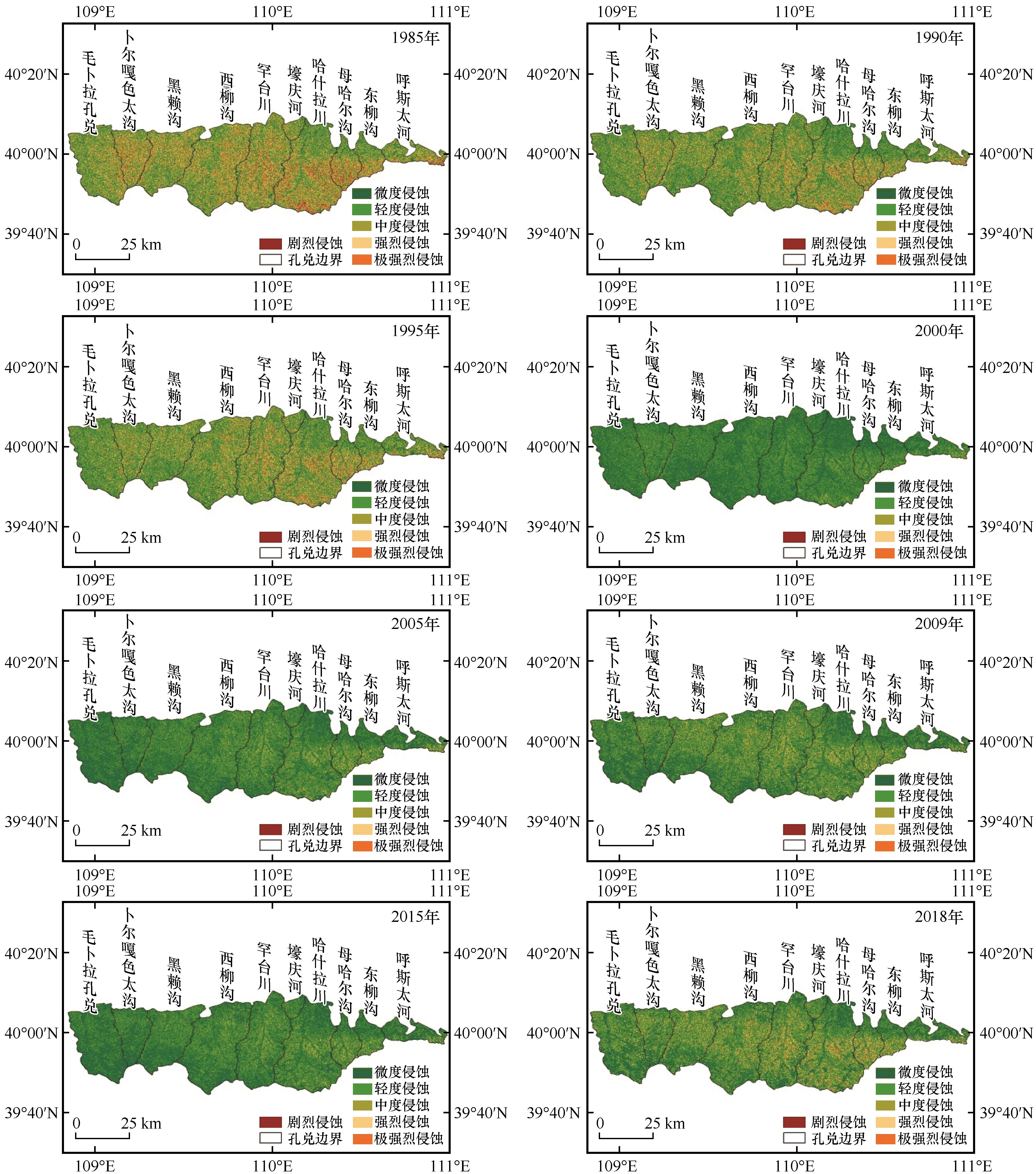
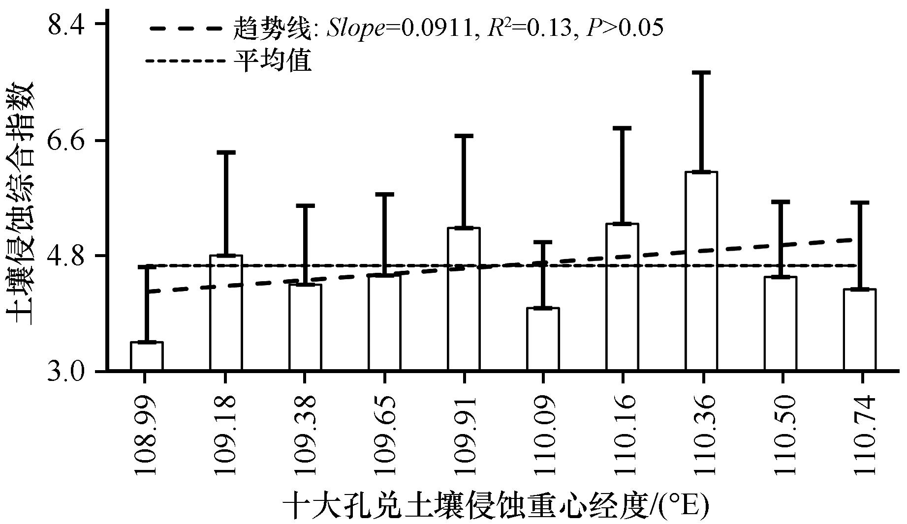
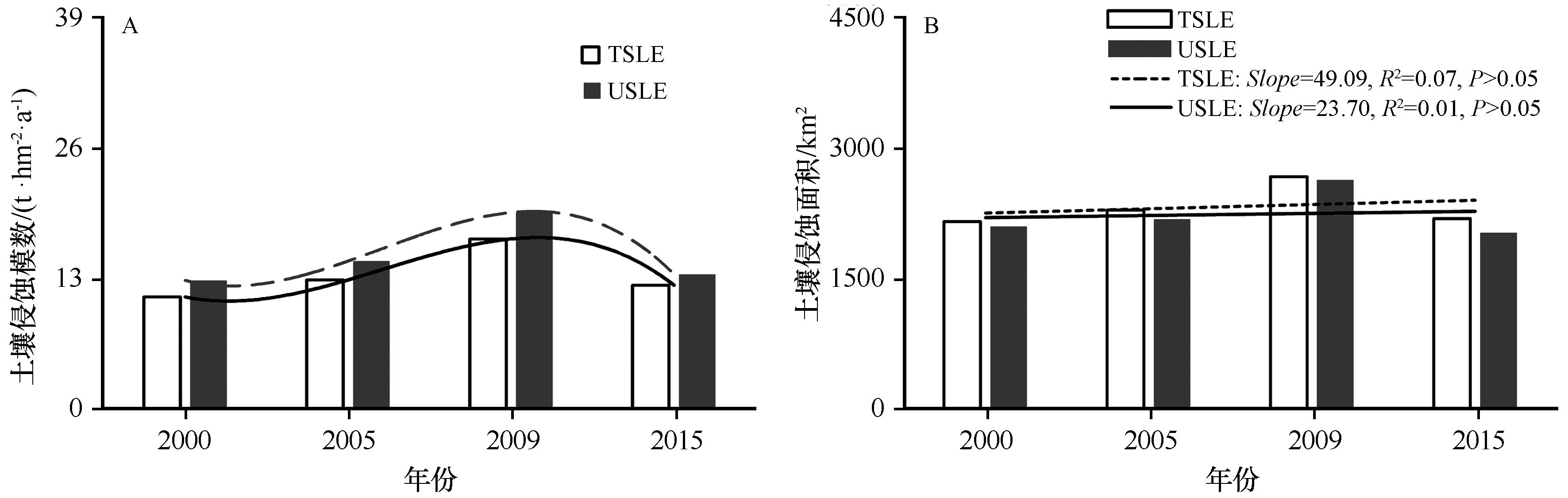
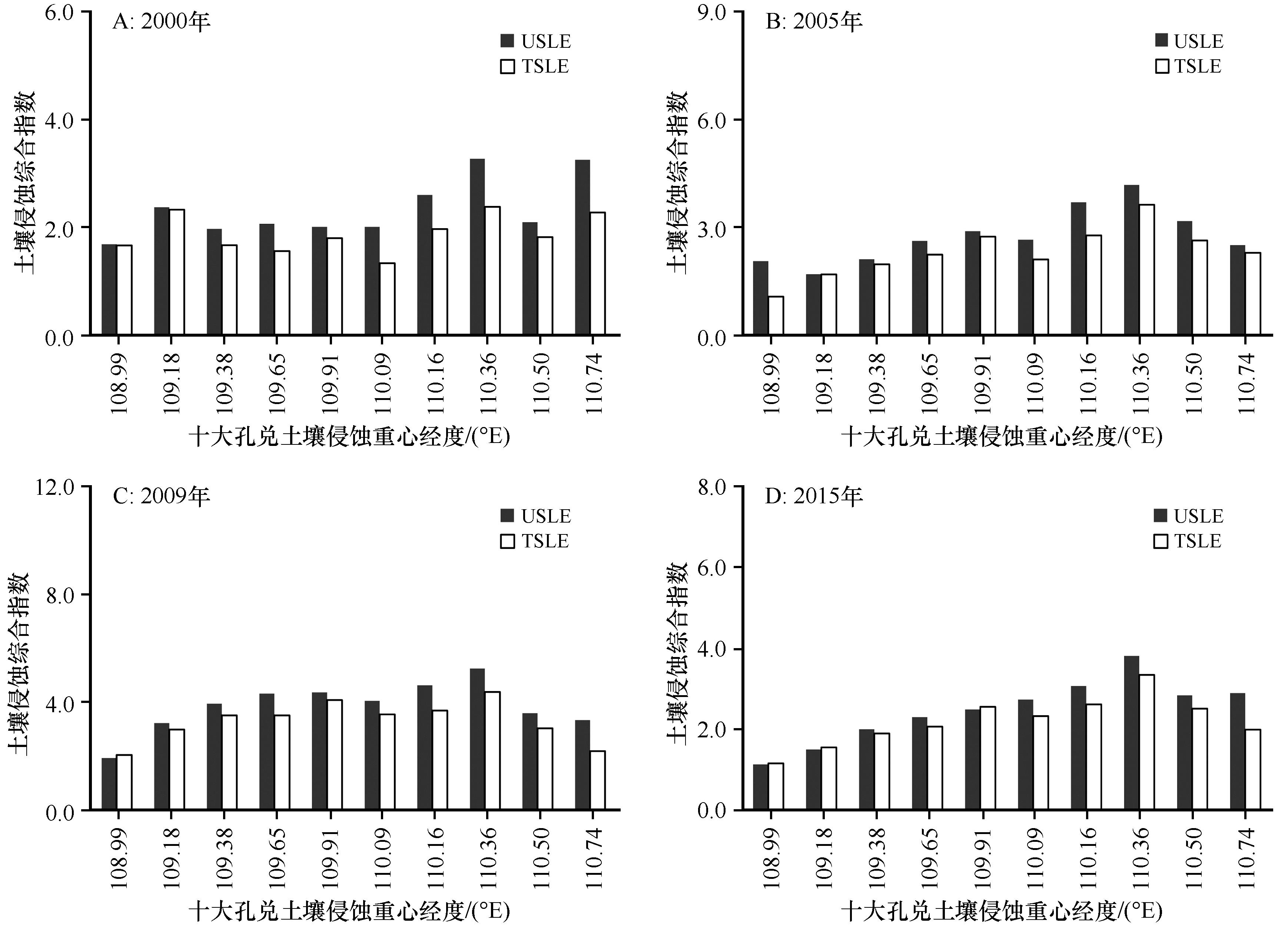
地形是土壤侵蚀进程的重要控制因子,在土壤侵蚀评价中发挥着重要作用。基于地形起伏表达构建了地形指数,结合降雨侵蚀力和植被盖度等建立了基于地形指数的土壤侵蚀方程,并分析了内蒙古自治区鄂尔多斯市北部十大孔兑砒砂岩黄土区1985—2018年土壤侵蚀时空变化特征。结果表明:(1)研究区多年土壤侵蚀模数整体有下降趋势但变化差异不显著(P>0.05),多年平均侵蚀模数为22.34 t·hm-2·a-1。1985年土壤侵蚀模数最大,2000年土壤侵蚀模数最小,1985—2000年呈下降趋势,2000—2018年呈上升趋势;(2)多年平均土壤侵蚀面积为2 956.07 km2,1985年土壤侵蚀面积最大,为4 047.14 km2,占总面积比例83%;2000年土壤侵蚀面积最小,为2 153.67 km2,占比44%。研究区1985—2000年以轻度、中度侵蚀强度类型为主,2000—2018年以微度、轻度侵蚀类型为主;(3)多年土壤侵蚀空间分布格局基本一致,土壤侵蚀综合指数由西至东增加,总体上呈现为东部侵蚀大于西部的特点,母哈尔沟土壤侵蚀综合指数最大,毛卜拉孔兑最小;(4)地形指数土壤侵蚀方程与通用土壤流失方程在土壤侵蚀模数和土壤侵蚀面积估算上均无显著差异(P>0.05)。

关键词: 通用土壤流失方程, 地形指数, 土壤侵蚀综合指数, 砒砂岩黄土区

Abstract:

Terrain is an important controlling factor affecting the process of soil erosion and plays an important role in the evaluation of soil erosion. In this paper, based on the expression of terrain relief, the terrain index was constructed, and the soil loss formula based on terrain index was established by combining rainfall erosivity and vegetation coverage. The temporal and spatial variation characteristics of soil erosion from 1985 to 2018 in the loess area of Ten Turbutries sandstone in the north of Ordos City, Inner Mongolia Autonomous region were analyzed. The main results are as follows: (1) the soil erosion modulus in the study area showed no significant decreasing trend for many years, and the average erosion modulus was 22.34 t·hm-2·a-1. The soil erosion modulus was the highest in 1985 and the lowest in 2000, and showed a downward trend from 1985 to 2000 and an upward trend from 2000 to 2018. (2) The average soil erosion area for multi-year was 2 956.07 km2. The soil erosion area was the largest in 1985 at 4 047.14 km2, accounting for 83% of the total area; it was the smallest in 2000 at 2 153.67 km2, accounting for 44%. There were mainly light and moderate erosion intensity grades in the study area from 1985 to 2000, and there were mainly slight and mild erosion intensity grades from 2000 to 2018. (3) The spatial distribution pattern of soil erosion had remained basically the same over the years. The comprehensive index of soil erosion was increasing from west to east, and the soil erosion in the east was greater than that in the west. Among them, Muhaergou had the largest soil erosion comprehensive index and Maobula was the smallest. (4) There was no significant difference in the estimation of soil erosion modulus and area between Terrain Soil Loss Equation and Universal Soil Loss Equation (P>0.05).

Key words: USLE, terrain index, comprehensive index of soil erosion, loess area of sandstone

中图分类号: