
- CN 62-1070/P
- ISSN 1000-694X
- Bimonthly 1981
Journal of Desert Research ›› 2025, Vol. 45 ›› Issue (2): 61-70.DOI: 10.7522/j.issn.1000-694X.2024.00107
Previous Articles Next Articles
Aokang Xu1,2( ), Tianqi Ji3(), Jing Shi2
Received:2024-04-29
Revised:2024-11-11
Online:2025-03-20
Published:2025-03-26
Contact:
Tianqi Ji
CLC Number:
Aokang Xu, Tianqi Ji, Jing Shi. Construction and optimization of ecological network of the Heihe River Basin (Gansu section)[J]. Journal of Desert Research, 2025, 45(2): 61-70.
Add to citation manager EndNote|Ris|BibTeX
URL: http://www.desert.ac.cn/EN/10.7522/j.issn.1000-694X.2024.00107
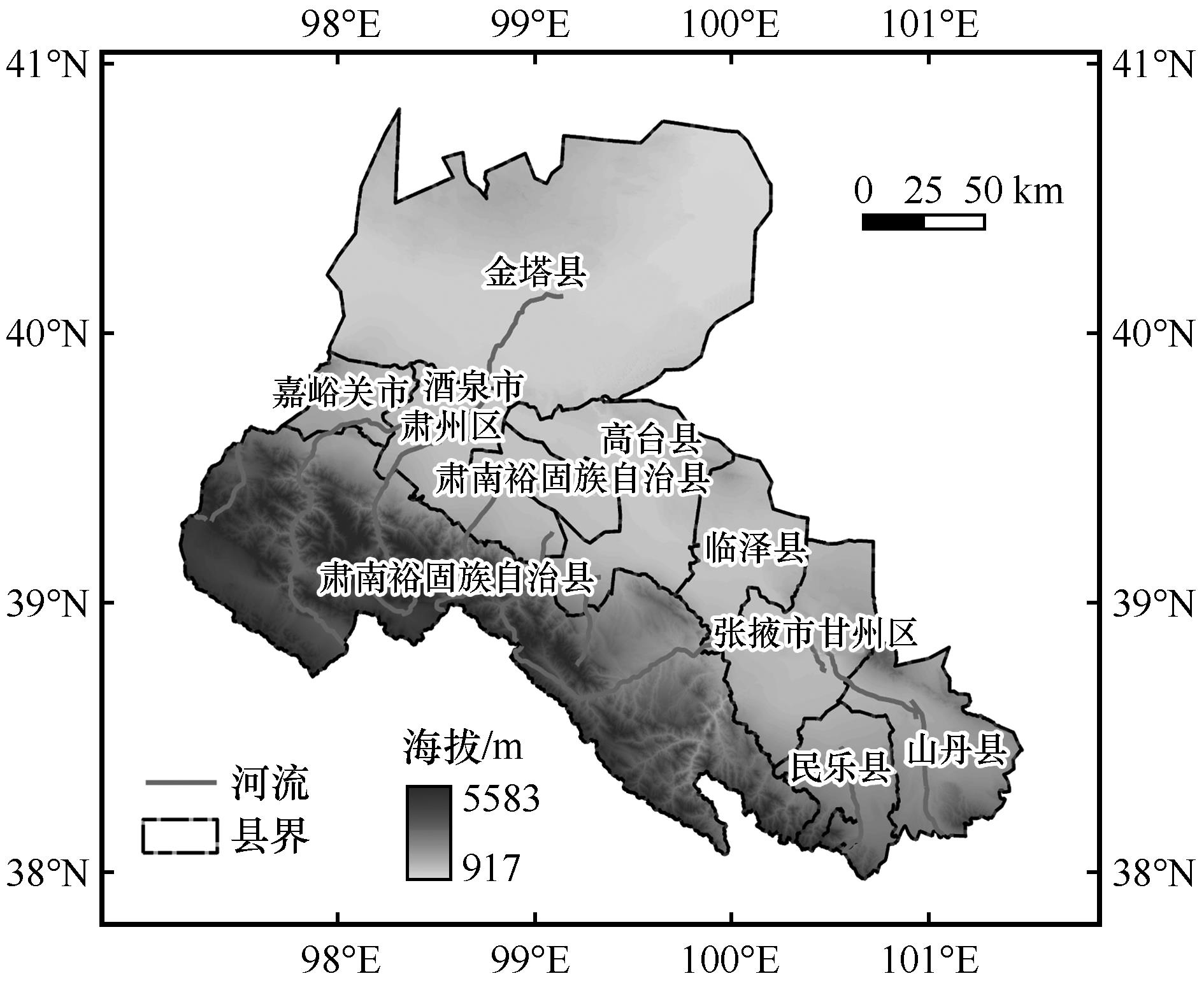
Fig.1 Overview of the study area
| 数据类别 | 数据格式 | 数据来源 |
|---|---|---|
| 土地利用 | 栅格,30 m×30 m | 中国科学院资源环境科学数据中心(http://wwwresdc.cn) |
| DEM | 栅格,30 m×30 m | 中国科学院资源环境科学数据中心(http://wwwresdc.cn) |
| 人口密度 | 栅格,1 000 m×1 000 m | 中国科学院资源环境科学数据中心(http://wwwresdc.cn) |
| GDP | 栅格,1 000 m×1 000 m | 中国科学院资源环境科学数据中心(http://wwwresdc.cn) |
| 土壤属性 | 栅格,1 000 m×1 000 m | 世界土壤数据库(HWSD)中国土壤数据集 |
| NDVI | 栅格,250 m×250 m | 美国地质调查局(USGS) |
| 气温、降水 | 栅格,1 000 m×1 000 m | 中国气象科学数据共享平台(http://data.cma.cn/) |
| 雪盖因子数据 | 栅格,1 000 m×1 000 m | 国家冰川冻土沙漠科学数据中心(http://wwwncdc.accn/portal/) |
| 社会经济统计数据 | 表格统计 | 《中国统计年鉴》《甘肃发展年鉴》《甘肃农村年鉴》《甘肃省水资源公报》《张掖市年鉴》 |
Table 1 Specific data sources and related descriptions
| 数据类别 | 数据格式 | 数据来源 |
|---|---|---|
| 土地利用 | 栅格,30 m×30 m | 中国科学院资源环境科学数据中心(http://wwwresdc.cn) |
| DEM | 栅格,30 m×30 m | 中国科学院资源环境科学数据中心(http://wwwresdc.cn) |
| 人口密度 | 栅格,1 000 m×1 000 m | 中国科学院资源环境科学数据中心(http://wwwresdc.cn) |
| GDP | 栅格,1 000 m×1 000 m | 中国科学院资源环境科学数据中心(http://wwwresdc.cn) |
| 土壤属性 | 栅格,1 000 m×1 000 m | 世界土壤数据库(HWSD)中国土壤数据集 |
| NDVI | 栅格,250 m×250 m | 美国地质调查局(USGS) |
| 气温、降水 | 栅格,1 000 m×1 000 m | 中国气象科学数据共享平台(http://data.cma.cn/) |
| 雪盖因子数据 | 栅格,1 000 m×1 000 m | 国家冰川冻土沙漠科学数据中心(http://wwwncdc.accn/portal/) |
| 社会经济统计数据 | 表格统计 | 《中国统计年鉴》《甘肃发展年鉴》《甘肃农村年鉴》《甘肃省水资源公报》《张掖市年鉴》 |
| 类型 | 理论依据 | 计算公式 | 变量释义 |
|---|---|---|---|
| 食物 供给 | 以归一化植被指数对农牧业产值空间化处理,农业产值以栅格NDVI值与耕地NDVI值的比分配,牧业产值以栅格NDVI值与草地NDVI值的比分配,水产品产值以栅格NDVI值与水域NDVI值的比分配,以表征各栅格的食物供给能[ | ||
| 碳固存 | 运用InVEST模型中的Carbon模块计算,土地利用类型碳密度系数根据Alam等[ | i为土地利用类型数量; | |
| 防风 固沙 | 通过植被的固沙量进行计算,裸土条件下的潜在风蚀量与植被覆盖条件下的实际风蚀量的差值[ | ||
| 产水 | 运用InVEST模型中的产水模块计算,即栅格的年降水量减去年实际蒸散量[ |
Table 2 Ecosystem services assessment
| 类型 | 理论依据 | 计算公式 | 变量释义 |
|---|---|---|---|
| 食物 供给 | 以归一化植被指数对农牧业产值空间化处理,农业产值以栅格NDVI值与耕地NDVI值的比分配,牧业产值以栅格NDVI值与草地NDVI值的比分配,水产品产值以栅格NDVI值与水域NDVI值的比分配,以表征各栅格的食物供给能[ | ||
| 碳固存 | 运用InVEST模型中的Carbon模块计算,土地利用类型碳密度系数根据Alam等[ | i为土地利用类型数量; | |
| 防风 固沙 | 通过植被的固沙量进行计算,裸土条件下的潜在风蚀量与植被覆盖条件下的实际风蚀量的差值[ | ||
| 产水 | 运用InVEST模型中的产水模块计算,即栅格的年降水量减去年实际蒸散量[ |
| 威胁源 | 权重 | 敏感水平 | 最大威胁 距离 | 衰减 类型 | |||
|---|---|---|---|---|---|---|---|
| 耕地 | 林地 | 草地 | 水域 | ||||
| 建设用地 | 1.0 | 0.50 | 0.70 | 0.65 | 0.70 | 8 | 指数 |
| 公路 | 0.8 | 0.30 | 0.20 | 0.35 | 0.40 | 5 | 指数 |
| 铁路 | 0.6 | 0.25 | 0.20 | 0.35 | 0.45 | 3 | 指数 |
| 未利用地 | 0.3 | 0.25 | 0.30 | 0.40 | 0.20 | 3 | 线性 |
| 耕地 | 0.2 | 0.20 | 0.40 | 0.45 | 0.50 | 1 | 线性 |
Table 3 Threat source data for different habitat types
| 威胁源 | 权重 | 敏感水平 | 最大威胁 距离 | 衰减 类型 | |||
|---|---|---|---|---|---|---|---|
| 耕地 | 林地 | 草地 | 水域 | ||||
| 建设用地 | 1.0 | 0.50 | 0.70 | 0.65 | 0.70 | 8 | 指数 |
| 公路 | 0.8 | 0.30 | 0.20 | 0.35 | 0.40 | 5 | 指数 |
| 铁路 | 0.6 | 0.25 | 0.20 | 0.35 | 0.45 | 3 | 指数 |
| 未利用地 | 0.3 | 0.25 | 0.30 | 0.40 | 0.20 | 3 | 线性 |
| 耕地 | 0.2 | 0.20 | 0.40 | 0.45 | 0.50 | 1 | 线性 |
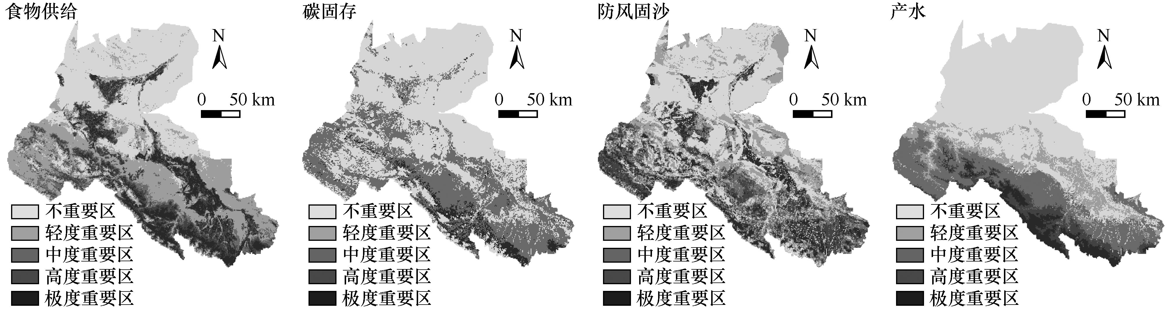
Fig.2 Spatial distribution of ecosystem service importance classification
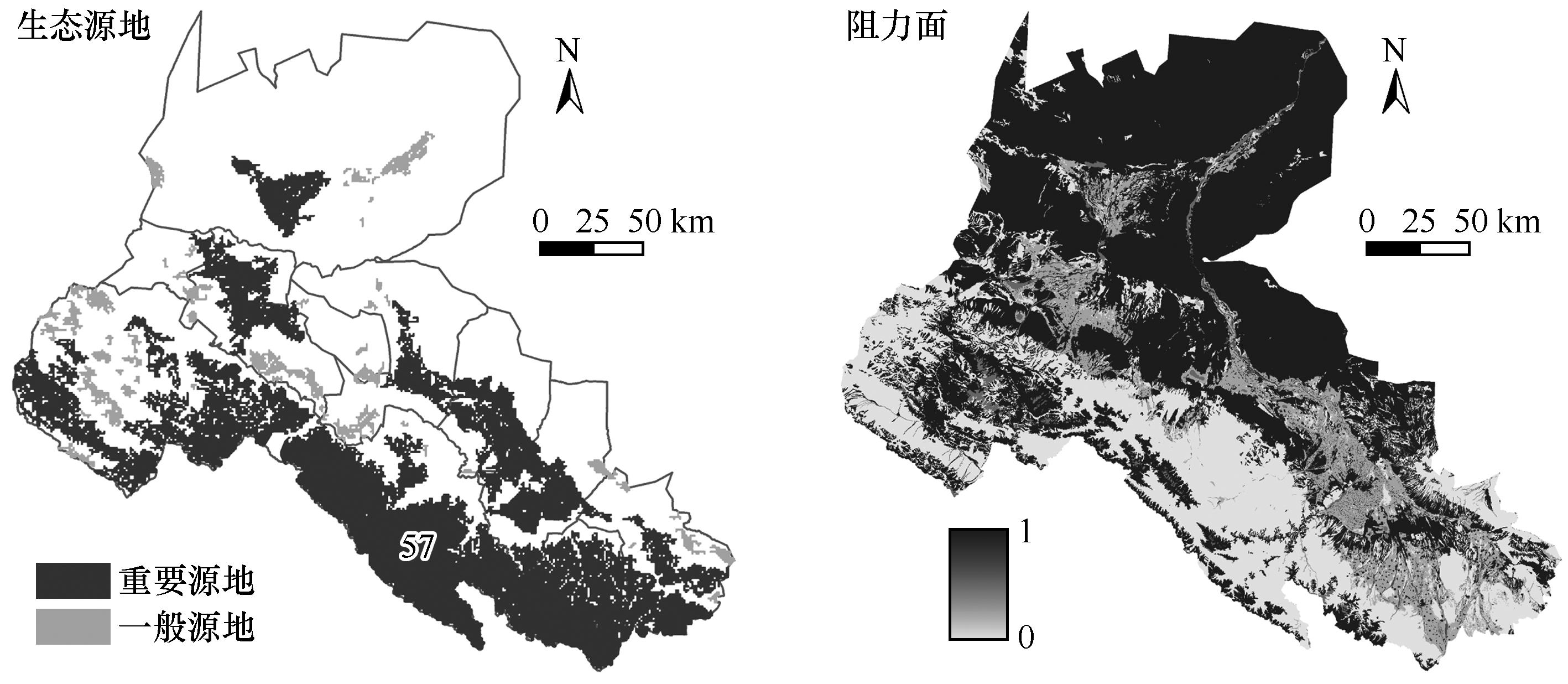
Fig.3 Spatial distribution of ecological sources and resistance surface
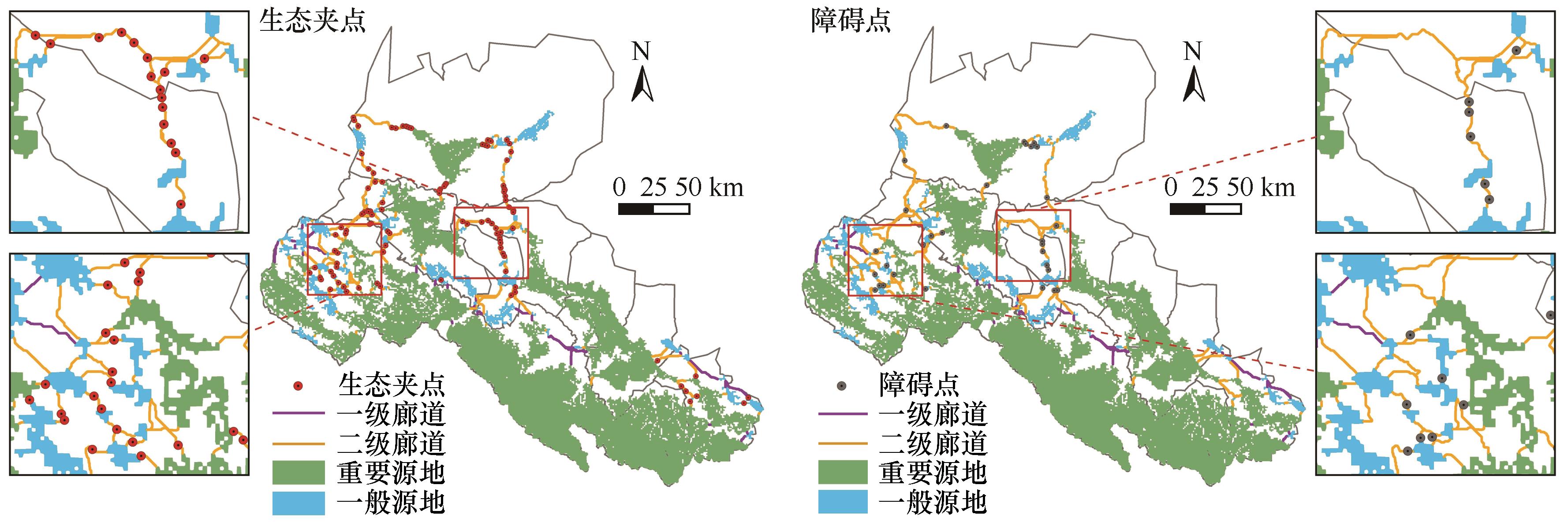
Fig.4 Spatial distribution of ecological corridors, ecological pinch points and barriers
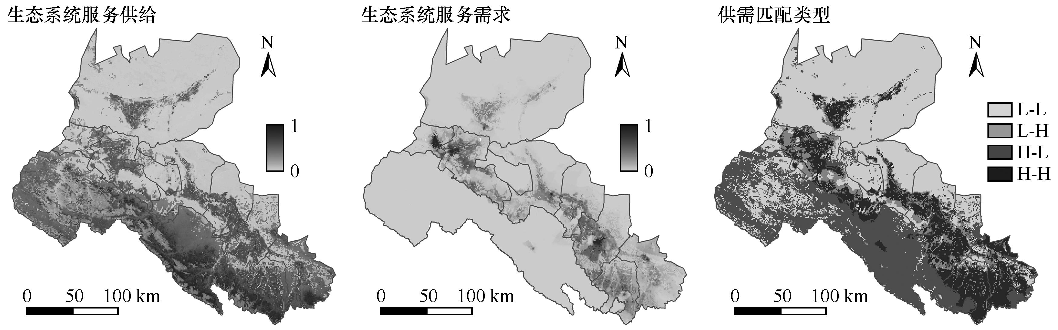
Fig.5 Spatial distribution of ecosystem service supply and demand
| 1 | Lewis S, Maslin M.Defining the Anthropocene[J].Nature,2015,519:171-180. |
| 2 | Lei K, Pan H Y, Lin C Y.A landscape approach towards ecological restoration and sustainable development of mining areas[J].Ecological Engineering,2016,90:320-325. |
| 3 | 董毓伊,冯秀丽,黄俊杰,等.国土空间生态保护修复重点区域识别研究:以宁波市为例[J].中国土地科学,2023,37(6):96-105. |
| 4 | 张学渊,魏伟,周亮,等.西北干旱区生态脆弱性时空演变分析[J].生态学报,2021,41(12):4707-4719. |
| 5 | 岳笑,张良侠,周德成,等.干旱-半干旱典型生态脆弱区生态脆弱性时空演变及驱动因子分析[J].环境生态学,2023,5(6):1-9. |
| 6 | Shuai N, Hu Y C, Gao M W,et al.Construction and optimization of ecological networks in karst regions based on multi-scale nesting:a case study in Guangxi Hechi,China[J].Ecological Informatics,2023,74:101963. |
| 7 | Pan J H, Liang J, Zhao C C.Identification and optimization of ecological security pattern in arid inland basin based on ordered weighted average and ant colony algorithm:a case study of Shule River Basin,NW China[J].Ecological Indicators,2023,154:110588. |
| 8 | Montis A D, Ganciu A, Cabras M,et al.Comparative ecological network analysis:an application to Italy[J].Land Use Policy,2019,81:714-724. |
| 9 | 彭建,赵会娟,刘焱序,等.区域生态安全格局构建研究进展与展望[J].地理研究,2017,36(3):407-419. |
| 10 | 蒙吉军,燕群,向芸芸.鄂尔多斯土地利用生态安全格局优化及方案评价[J].中国沙漠,2014,34(2):590-596. |
| 11 | 韩阳媚,王锦,于世涛,等.塞罕坝地区生态网络构建及优化[J].干旱区资源与环境,2023,37(5):112-121. |
| 12 | 刘秀萍,李新宇,李延明,等.快速城市化地区生态网络构建与优化:以北京市大兴区为例[J].生态学报,2023,43(20):8321-8331. |
| 13 | 于强,岳德鹏,张启斌,等.磴口县景观格局演变特征及生态网络构建[J].中国沙漠,2017,37(3):601-609. |
| 14 | 王梦頔,刘家明,朱鹤,等.基于连通性与敏感性的山岳型景区生态安全格局构建:以山西省云丘山为例[J].中国生态旅游,2021,11(2):266-282. |
| 15 | 徐文彬,尹海伟,孔繁花.基于生态安全格局的南京都市区生态控制边界划定[J].生态学报,2017,37(12):4019-4028. |
| 16 | Zhou G J, Huan Y Z, Wang L Q,et al.Linking ecosystem services and circuit theory to identify priority conservation and restoration areas from an ecological network perspective[J].Science of The Total Environment,2023,873:162261. |
| 17 | 彭建,李慧蕾,刘焱序,等.雄安新区生态安全格局识别与优化策略[J].地理学报,2018,73(4):701-710. |
| 18 | Gao M W, Hu Y C, Bai Y P.Construction of ecological security pattern in national land space from the perspective of the community of life in mountain,water,forest,field,lake and grass:a case study in Guangxi Hechi,China[J].Ecological Indicators,2022,139:108867. |
| 19 | Peng J, Zhao H, Liu Y.Urban ecological corridors construction:a review[J].Acta Ecologica Sinica,2016,37(1):23-30. |
| 20 | 倪庆琳,丁忠义,侯湖平,等.基于电路理论的生态格局识别与保护研究:以宁武县为例[J].干旱区资源与环境,2019,33(5):67-73. |
| 21 | 荣月静,严岩,王辰星,等.基于生态系统服务供需的雄安新区生态网络构建与优化[J].生态学报,2020,40(20):7197-7206. |
| 22 | Jia Q Q, Jiao L M, Lian X H,et al.Linking supply-demand balance of ecosystem services to identify ecological security patterns in urban agglomerations[J].Sustainable Cities and Society,2023,92:1-13. |
| 23 | Wang J, Zhai T L, Lin Y F,et al.Spatial imbalance and changes in supply and demand of ecosystem services in China[J].Science of the Total Environment,2019,657:781-791 |
| 24 | Tan J, Peng L, Wu W,et al.Mapping the evolution patterns of urbanization,ecosystem service supply-demand,and human well-being:a tree-like landscape perspective[J].Ecological Indicators,2023,154:110591. |
| 25 | 韩子言,蒙吉军,邹易,等.1982-2017年黑河流域植被指数动态及其对气候变化与生态建设工程的响应[J].中国沙漠,2023,43(3):96-106. |
| 26 | Cheng G D, Li X, Zhao W Z,et al.Integrated study of the water-ecosystem-economy in the Heihe River Basin[J].National Science Review,2014,1(3):413-428. |
| 27 | 黄俊达,黄金玲,陈超劲.以自然保护地为主体的广州市域生态网络构建[J].应用生态学报,2024,35(1):247-254. |
| 28 | Peng J, Hu X X, Qiu S J,et al.Multifunctional landscapes identification and associated development zoning in mountainous area[J].Science of The Total Environment,2019,660:765-775. |
| 29 | 杜可心,张福平,冯起,等.黑河流域生态系统服务的地形梯度效应及生态分区[J].中国沙漠,2023,43(2):139-149. |
| 30 | Alam S A, Starr M, Clark B J F.Tree biomass and soil organic carbon densities across the Sudanese woodland savannah:a regional carbon sequestration study[J].Journal of Arid Environments,2013,89:67-76. |
| 31 | 陈光水,杨玉盛,刘乐中,等.森林地下碳分配(TBCA)研究进展[J].亚热带资源与环境学报,2007,2(1):34-42. |
| 32 | 牛丽楠,邵全琴,宁佳,等.西部地区生态状况变化及生态系统服务权衡与协同[J].地理学报,2022,77(1):1-14. |
| 33 | 李芳,张金龙,杨环.基于InVEST模型的黑河流域上游1990-2018年产水量模拟[J].高原气象,2022,41(3):698-707. |
| 34 | Lin Q, Mao J Y, Wu J S,et al.Ecological security pattern analysis based on InVEST and least-cost path model:a case study of Dongguan water village[J].Sustainability,2016,8(2):172. |
| 35 | Terrado M, Sabater S, Chaplin-Kramer B,et al.Model development for the assessment of terrestrial and aquatic habitat quality in conservation planning[J].Science of the Total Environment,2016,540(1):63-70. |
| 36 | 李骞国,王录仓,石培基,等.基于生境质量的绿洲城镇增长边界划定:以黑河中游地区为例[J].经济地理,2020,40(3):92-101. |
| 37 | 覃彬桂,林伊琳,赵俊三,等.基于InVEST模型和电路理论的昆明市国土空间生态修复关键区域识别[J].中国环境科学,2023,43(2):809-820. |
| 38 | 黄孟冬,肖玉,秦克玉,等.1980-2018年浑善达克地区防风固沙服务时空变化及其驱动因素[J].生态学报,2022,42(18):7612-7629. |
| 39 | 韩增林,刘澄浩,闫晓露,等.基于生态系统服务供需匹配与耦合协调的生态管理分区:以大连市为例[J].生态学报,2021,41(22):9064-9075. |
| 40 | Xiong X Y, Meng M.Regionalization and optimization strategy of ecological management in Xinjiang,China based on supply-demand relationship and spatial flow of ecosystem services[J].Chinese Journal of Applied Ecology,2023,34:2237-2248. |
| 41 | 岳文泽,侯丽,夏皓轩,等.基于生态系统服务供需平衡的宁夏固原生态修复分区与优化策略[J].应用生态学报,2022,33(1):149-158. |
| 42 | 潘竟虎,王云.基于CVOR和电路理论的讨赖河流域生态安全评价及生态格局优化[J].生态学报,2021,41(7):2582-2595. |
| 43 | 石晶,石培基,王梓洋,等.基于复杂网络理论和电路模型的酒泉市生态网络优化[J].应用生态学报,2024,35(1):237-246. |
| 44 | Xu A K, Hu M J, Shi J,et al.Construction and optimization of ecological network in inland river basin based on circuit theory,complex network and ecological sensitivity:a case study of Gansu section of Heihe River Basin[J].Ecological Modelling,2024,488:110578. |
| 45 | 金银丽,周冬梅,周凡,等.疏勒河流域生态安全网络构建及优化[J].应用生态学报,2023,34(4):1063-1072. |
| 46 | 孙茂森,王让会,宁虎森.阿克苏河流域生态网络构建[J].干旱区研究,2023,40(9):1509-1516. |
| 47 | 弓灏洁,常金生,杜雨阳.基于MCR和重力模型的县域生态网络构建[J].测绘通报,2023(11):23-29. |
| 48 | Gao G Y, Shen Q, Zhang Y,et al.Determining spatio-temporal variations of ecological water consumption by natural oases for sustainable water resources allocation in a hyper-arid endorheic basin[J].Journal of Cleaner Production,2018,185:1-13. |
| 49 | 康尔泗,李新,张济世,等.甘肃河西地区内陆河流域荒漠化的水资源问题[J].冰川冻土,2004(6):657-667. |
| 50 | Lina Z, Zhen Q, Erqi X.Improving the ecological network optimization with landscape connectivity:a case study of Neijiang City,Sichuan Province[J].Environmental Science and Pollution Research International,2023,30(19):54753-54769. |
| 51 | 韩王亚,夏双双,周维,等.基于生态廊道识别的拉萨河流域生态安全格局构建[J].生态学报,2023,43(21):8948-8957. |
| 52 | Wang Y, Pan J H.Building ecological security patterns based on ecosystem services value reconstruction in an arid inland basin:a case study in Ganzhou District,NW China[J].Journal of Cleaner Production,2019,241:118337. |
| 53 | Wu Y D, Han Z Y, Meng J J,et al.Circuit theory-based ecological security pattern could promote ecological protection in the Heihe River Basin of China[J].Environmental Science and Pollution Research,2023,30:27340-27356. |
| [1] | Jiliang Liu, Yilin Feng, Yongzhen Wang, Chengchen Pan, Tianling Bao, Jialong Ren, Wenzhi Zhao. Effects of restoration of artificial sand-fixing vegetation on the diversity of reptiles and mammals in the middle reaches of the Heihe River Basin [J]. Journal of Desert Research, 2024, 44(6): 167-177. |
| [2] | Jun Lei, Xinping Cheng, Chun Xue, Hongmei Liu, Yuhong Zhao, Mingmin Xiao. The characteristics and stability of plant communities in the northern desert area of the middle reaches of the Heihe River Basin [J]. Journal of Desert Research, 2024, 44(6): 187-194. |
| [3] | Deliang Zhou, Mingxia Yang, Jingya Su, Yu Bai. Research progress in evaluating the value of watershed ecosystem services [J]. Journal of Desert Research, 2024, 44(4): 149-164. |
| [4] | Xiaohong Deng, Xueqing Wang, Jinhuang Mao, Zongxing Li. Spatial targeting and compensation mode of win-win payments for ecosystem services in ecological function zones [J]. Journal of Desert Research, 2024, 44(4): 262-274. |
| [5] | Ziyan Han, Jijun Meng, Yi Zou, Likai Zhu. Vegetation dynamics and their response to climate change and ecological protection projects in the Heihe River Basin from 1982 to 2017 [J]. Journal of Desert Research, 2023, 43(3): 96-106. |
| [6] | Kexin Du, Fuping Zhang, Qi Feng, Yongfen Wei, Jiawei Yang. Topographic gradient effect and ecological zoning of ecosystem services in Heihe River Basin [J]. Journal of Desert Research, 2023, 43(2): 139-149. |
| [7] | Shengtang Wang, Yingchun Ge, Shaokun Wang, Xiaolong Zhang, Ying Yang. Responses of plant species diversity to land use change: a case study in the Heihe River Basin [J]. Journal of Desert Research, 2022, 42(6): 221-232. |
| [8] | Jing Luo, Xiaoxia Huang, Hong Cheng, Ning Jiang, Xuyu Mo, Xiuyu Wang. Impacts of landscape structure changes on ecosystem services in the Hunshandake Sandy Land [J]. Journal of Desert Research, 2022, 42(4): 99-109. |
| [9] | Shuo Qiao, Haibing Wang, Hejun Zuo, Xiya Liu, Yueru Wu. Evolution of ecological service value and network pattern of Mu Us Sandy Land [J]. Journal of Desert Research, 2022, 42(3): 118-126. |
| [10] | Yaowen Zhang, Bo Zhang, Rongpeng Yao, Libing Wang. Temporal and spatial changes of vegetation coverage and water production in the Weihe River Basin from 2000 to 2020 [J]. Journal of Desert Research, 2022, 42(2): 223-233. |
| [11] | Yanhui Lei, Guodong Ding, Zimeng Li, Wenfeng Chi, Guanglei Gao, Yuanyuan Zhao. Land use/cover change and its ecosystem service value response in the Beijing-Tianjin sandstorm source control project area [J]. Journal of Desert Research, 2021, 41(6): 29-40. |
| [12] | Mengtao Han, Jianjun Tu, Guiping Xu, Li Jiang. Spatio-temporal coordination between aquatic ecosystem services and economic development in the Yellow River Basin [J]. Journal of Desert Research, 2021, 41(4): 167-176. |
| [13] | Li Li, Qingqing Zhang, Yamei Wang, Hong Li, Xinfeng Zhao. Comprehensive assessment of ecosystem vulnerability, the value of service function and risk in Kezi River Basin in 2000-2018 [J]. Journal of Desert Research, 2021, 41(2): 164-172. |
| [14] | Jun Lei, Xiaohu Yang, Hongmei Liu, Yuhong Zhao, Juping Fan, Caixia Guo. The characteristics of desert vegetation biomass and its influencing factors in the middle reaches of the Heihe River [J]. Journal of Desert Research, 2021, 41(1): 203-208. |
| [15] | Liuwen Dong, Jialong Han, Wenzhi Zhao, Jiliang Liu, Yibin Ba. Comparison of ground arthropod community between Lake Wetland and adjacent sand dune in Heihe River Basin [J]. Journal of Desert Research, 2020, 40(6): 250-258. |
| Viewed | ||||||
|
Full text |
|
|||||
|
Abstract |
|
|||||
©2018Journal of Desert Research
Tel:0931-8267545
Email:caiedit@lzb.ac.cn;desert@lzb.ac.cn
Support:Magtech
