中国沙漠 ›› 2023, Vol. 43 ›› Issue (3): 199-209.DOI: 10.7522/j.issn.1000-694X.2022.00125
• • 上一篇
黄梦真( ), 鲁瑞洁(), 赵瑾, 马罗
收稿日期:2022-08-03
修回日期:2022-09-29
出版日期:2023-05-20
发布日期:2023-05-31
通讯作者:
鲁瑞洁
作者简介:鲁瑞洁(E-mail: ruijielu@bnu.edu.cn)基金资助:
Mengzhen Huang(), Ruijie Lu(), Jin Zhao, Luo Ma
Received:2022-08-03
Revised:2022-09-29
Online:2023-05-20
Published:2023-05-31
Contact:
Ruijie Lu
摘要:
开展土壤质量评价是有效保护土壤的关键环节,对保障生态系统稳定和区域生态安全及可持续发展至关重要。柴达木盆地是青藏高原土壤风蚀最严重的地区,风蚀导致的土壤系统的变化深刻影响着青藏高原生态安全屏障和水源涵养功能。本研究基于对柴达木盆地典型风蚀区表层土壤的理化性质分析,利用主成分分析法建立最小数据集,构建土壤质量综合指数并进行土壤质量评价。结果表明:(1)柴达木盆地土壤有机质、全氮、全磷、有效磷、容重、碳酸钙含量仅达到全国第二次土壤普查六级土壤肥力分级标准下的四级到六级水平指标评分空间分布上,有机质、全氮、有效磷、全磷、砂粒含量东高西低,速效钾、砾石含量则西高东低。(2)柴达木盆地土壤质量评价最小数据集(MDS)包括容重、有机质、全磷、速效钾、砂粒含量5个指标,基于最小数据集构建的土壤质量综合指数(MDS-SQI)具有较好的代表性和适用性。(3)盆地整体土壤质量较差,且呈现出东部土壤质量优于西部的分布规律。将研究区的土壤质量由高到低划分为Ⅰ~Ⅴ级,Ⅰ~Ⅱ级土壤样点主要分布在东部地区,且所占面积较小,中部和西部地区主要分布Ⅲ~Ⅴ级样点。(4)MDS-SQI和风蚀强度显著负相关,柴达木盆地土壤风蚀的防治是遏制土壤质量继续恶化的重要措施。
中图分类号:
黄梦真, 鲁瑞洁, 赵瑾, 马罗. 柴达木盆地典型风蚀区土壤质量评价[J]. 中国沙漠, 2023, 43(3): 199-209.
Mengzhen Huang, Ruijie Lu, Jin Zhao, Luo Ma. Assessment of soil quality in typical wind erosion area of Qaidam Basin[J]. Journal of Desert Research, 2023, 43(3): 199-209.
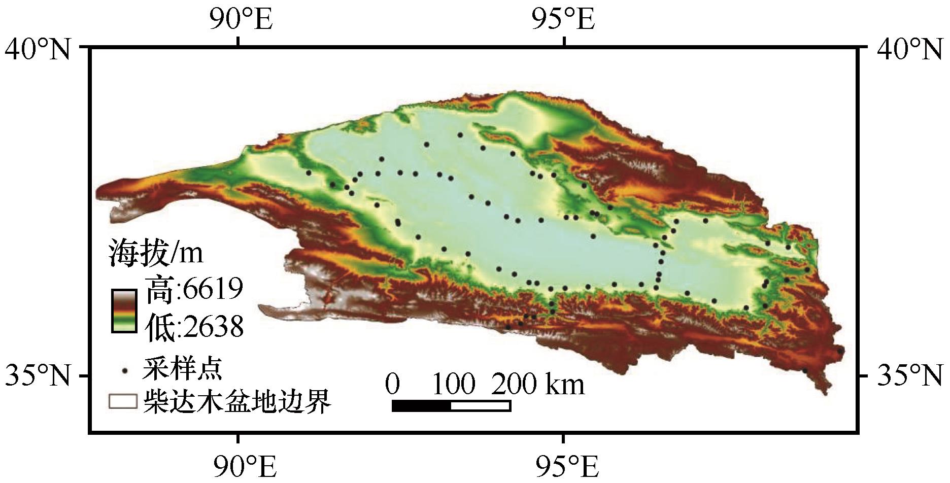
图1 柴达木盆地采样点位置
Fig.1 Location of sampling points in Qaidam Basin
| 参数 | 容重 /(g·cm-3) | pH值 | 碳酸钙 /% | 有机质 /% | 全氮 /% | 全磷 /% | 全钾 /% | 有效磷 /(mg·kg-1) | 速效钾 /(mg·kg-1) | 黏粒 /% | 粉粒 /% | 砂粒 /% | 砾石 /% |
|---|---|---|---|---|---|---|---|---|---|---|---|---|---|
| 变异系数 | 0.176 | 0.062 | 0.584 | 3.205 | 1.980 | 0.504 | 0.396 | 0.834 | 2.356 | 1.037 | 0.602 | 0.410 | 1.447 |
| 最小值 | 0.847 | 7.020 | 0.150 | 0.018 | 0.003 | 0.003 | 0.201 | 0.016 | 66.135 | 0.000 | 3.655 | 1.642 | 0.000 |
| 最大值 | 1.928 | 9.460 | 33.030 | 23.284 | 0.902 | 0.144 | 5.301 | 42.984 | 11 854.503 | 15.760 | 88.430 | 96.345 | 63.910 |
| 平均值 | 1.412 | 8.208 | 8.866 | 0.765 | 0.048 | 0.056 | 1.669 | 7.113 | 712.997 | 2.751 | 35.110 | 51.684 | 10.422 |
| 标准差 | 0.248 | 0.510 | 5.176 | 2.453 | 0.095 | 0.028 | 0.661 | 5.931 | 1 679.794 | 2.854 | 21.130 | 21.168 | 15.081 |
表1 柴达木盆地采样点土壤指标状况
Table 1 Soil indicators of sampling points in Qaidam Basin
| 参数 | 容重 /(g·cm-3) | pH值 | 碳酸钙 /% | 有机质 /% | 全氮 /% | 全磷 /% | 全钾 /% | 有效磷 /(mg·kg-1) | 速效钾 /(mg·kg-1) | 黏粒 /% | 粉粒 /% | 砂粒 /% | 砾石 /% |
|---|---|---|---|---|---|---|---|---|---|---|---|---|---|
| 变异系数 | 0.176 | 0.062 | 0.584 | 3.205 | 1.980 | 0.504 | 0.396 | 0.834 | 2.356 | 1.037 | 0.602 | 0.410 | 1.447 |
| 最小值 | 0.847 | 7.020 | 0.150 | 0.018 | 0.003 | 0.003 | 0.201 | 0.016 | 66.135 | 0.000 | 3.655 | 1.642 | 0.000 |
| 最大值 | 1.928 | 9.460 | 33.030 | 23.284 | 0.902 | 0.144 | 5.301 | 42.984 | 11 854.503 | 15.760 | 88.430 | 96.345 | 63.910 |
| 平均值 | 1.412 | 8.208 | 8.866 | 0.765 | 0.048 | 0.056 | 1.669 | 7.113 | 712.997 | 2.751 | 35.110 | 51.684 | 10.422 |
| 标准差 | 0.248 | 0.510 | 5.176 | 2.453 | 0.095 | 0.028 | 0.661 | 5.931 | 1 679.794 | 2.854 | 21.130 | 21.168 | 15.081 |
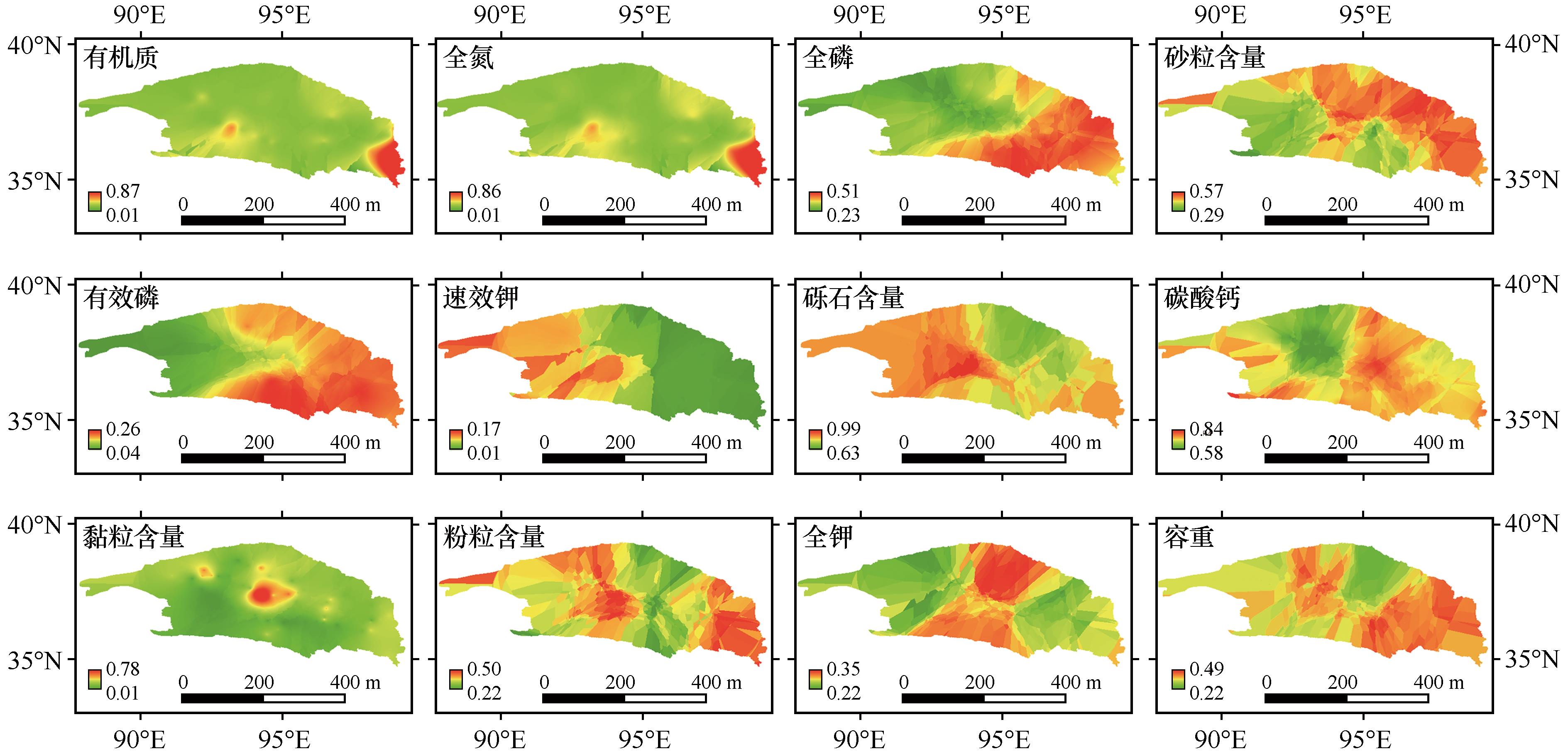
图2 柴达木盆地各土壤指标空间分布
Fig.2 Spatial distribution of soil indicacors in Qaidam Basin
| 土壤指标 | 全氮 | 全磷 | 全钾 | 有效磷 | 速效钾 | 有机质 | 黏粒 含量 | 粉粒 含量 | 容重 | pH值 | 碳酸钙 | 砂粒 含量 | 砾石含量 |
|---|---|---|---|---|---|---|---|---|---|---|---|---|---|
| 全氮 | 1.000 | ||||||||||||
| 全磷 | -0.073 | 1.000 | |||||||||||
| 全钾 | 0.099 | 0.143 | 1.000 | ||||||||||
| 有效磷 | 0.124 | 0.527** | -0.010 | 1.000 | |||||||||
| 速效钾 | 0.009 | -0.087 | 0.327** | -0.127 | 1.000 | ||||||||
| 有机质 | 0.987** | -0.089 | 0.078 | 0.108 | -0.004 | 1.000 | |||||||
| 黏粒含量 | 0.034 | -0.033 | 0.135 | -0.049 | 0.244* | 0.015 | 1.000 | ||||||
| 粉粒含量 | 0.249* | -0.015 | -0.124 | 0.095 | 0.340** | 0.182 | 0.443** | 1.000 | |||||
| 容重 | -0.295* | 0.197 | 0.165 | -0.028 | -0.465** | -0.270* | 0.037 | -0.562** | 1.000 | ||||
| pH值 | -0.174 | 0.349** | 0.135 | 0.260* | -0.102 | -0.206 | -0.147 | -0.141 | 0.368** | 1.000 | |||
| 碳酸钙 | -0.084 | -0.030 | -0.222 | -0.016 | -0.086 | -0.095 | 0.196 | 0.326** | -0.095 | 0.075 | 1.000 | ||
| 砂粒含量 | -0.151 | 0.057 | 0.026 | -0.042 | -0.226 | -0.088 | -0.530** | -0.766** | 0.194 | -0.044 | -0.307** | 1.000 | |
| 砾石含量 | -0.159 | -0.054 | 0.121 | -0.071 | -0.228* | -0.146 | -0.087 | -0.462** | 0.545** | 0.301** | -0.078 | -0.206 | 1.000 |
表2 土壤指标相关性分析
Table 2 Correlation of soil indicators
| 土壤指标 | 全氮 | 全磷 | 全钾 | 有效磷 | 速效钾 | 有机质 | 黏粒 含量 | 粉粒 含量 | 容重 | pH值 | 碳酸钙 | 砂粒 含量 | 砾石含量 |
|---|---|---|---|---|---|---|---|---|---|---|---|---|---|
| 全氮 | 1.000 | ||||||||||||
| 全磷 | -0.073 | 1.000 | |||||||||||
| 全钾 | 0.099 | 0.143 | 1.000 | ||||||||||
| 有效磷 | 0.124 | 0.527** | -0.010 | 1.000 | |||||||||
| 速效钾 | 0.009 | -0.087 | 0.327** | -0.127 | 1.000 | ||||||||
| 有机质 | 0.987** | -0.089 | 0.078 | 0.108 | -0.004 | 1.000 | |||||||
| 黏粒含量 | 0.034 | -0.033 | 0.135 | -0.049 | 0.244* | 0.015 | 1.000 | ||||||
| 粉粒含量 | 0.249* | -0.015 | -0.124 | 0.095 | 0.340** | 0.182 | 0.443** | 1.000 | |||||
| 容重 | -0.295* | 0.197 | 0.165 | -0.028 | -0.465** | -0.270* | 0.037 | -0.562** | 1.000 | ||||
| pH值 | -0.174 | 0.349** | 0.135 | 0.260* | -0.102 | -0.206 | -0.147 | -0.141 | 0.368** | 1.000 | |||
| 碳酸钙 | -0.084 | -0.030 | -0.222 | -0.016 | -0.086 | -0.095 | 0.196 | 0.326** | -0.095 | 0.075 | 1.000 | ||
| 砂粒含量 | -0.151 | 0.057 | 0.026 | -0.042 | -0.226 | -0.088 | -0.530** | -0.766** | 0.194 | -0.044 | -0.307** | 1.000 | |
| 砾石含量 | -0.159 | -0.054 | 0.121 | -0.071 | -0.228* | -0.146 | -0.087 | -0.462** | 0.545** | 0.301** | -0.078 | -0.206 | 1.000 |
| 土壤指标 | 主成分 | Norm值 | 公因子 方差 | 分组 | ||||
|---|---|---|---|---|---|---|---|---|
| 1 | 2 | 3 | 4 | 5 | ||||
| 容重 | -0.159 | 0.837 | -0.195 | 0.131 | 0.022 | 1.316 | 0.781 | 2 |
| pH值 | 0.059 | 0.433 | -0.187 | 0.569 | 0.045 | 1.042 | 0.552 | 4 |
| 碳酸钙 | 0.486 | -0.043 | -0.153 | 0.036 | -0.528 | 1.013 | 0.542 | 5 |
| 有机质 | 0.020 | -0.110 | 0.978 | -0.026 | 0.042 | 1.430 | 0.972 | 3 |
| 全氮 | 0.077 | -0.124 | 0.977 | 0.004 | 0.052 | 1.435 | 0.978 | 3 |
| 全磷 | -0.056 | 0.013 | -0.088 | 0.853 | 0.099 | 1.160 | 0.748 | 4 |
| 全钾 | 0.043 | 0.189 | 0.076 | 0.111 | 0.837 | 1.075 | 0.757 | 5 |
| 有效磷 | -0.008 | -0.094 | 0.168 | 0.823 | -0.093 | 1.144 | 0.723 | 4 |
| 速效钾 | 0.309 | -0.477 | -0.136 | -0.127 | 0.650 | 1.193 | 0.780 | 5 |
| 黏粒含量 | 0.733 | 0.010 | -0.023 | -0.087 | 0.191 | 1.155 | 0.581 | 1 |
| 粉粒含量 | 0.763 | -0.536 | 0.140 | 0.077 | -0.101 | 1.442 | 0.905 | 1 |
| 砂粒含量 | -0.929 | -0.050 | -0.115 | -0.010 | 0.041 | 1.439 | 0.880 | 1 |
| 砾石含量 | 0.068 | 0.865 | -0.036 | -0.083 | 0.052 | 1.303 | 0.764 | 2 |
| 特征值 | 2.358 | 2.228 | 2.102 | 1.798 | 1.479 | |||
| 解释度 | 18.136 | 17.135 | 16.173 | 13.827 | 11.375 | |||
| 累积解释度 | 18.136 | 35.271 | 51.444 | 65.271 | 76.645 | |||
表3 主成分分析结果
Table 3 The results of principal component analysis
| 土壤指标 | 主成分 | Norm值 | 公因子 方差 | 分组 | ||||
|---|---|---|---|---|---|---|---|---|
| 1 | 2 | 3 | 4 | 5 | ||||
| 容重 | -0.159 | 0.837 | -0.195 | 0.131 | 0.022 | 1.316 | 0.781 | 2 |
| pH值 | 0.059 | 0.433 | -0.187 | 0.569 | 0.045 | 1.042 | 0.552 | 4 |
| 碳酸钙 | 0.486 | -0.043 | -0.153 | 0.036 | -0.528 | 1.013 | 0.542 | 5 |
| 有机质 | 0.020 | -0.110 | 0.978 | -0.026 | 0.042 | 1.430 | 0.972 | 3 |
| 全氮 | 0.077 | -0.124 | 0.977 | 0.004 | 0.052 | 1.435 | 0.978 | 3 |
| 全磷 | -0.056 | 0.013 | -0.088 | 0.853 | 0.099 | 1.160 | 0.748 | 4 |
| 全钾 | 0.043 | 0.189 | 0.076 | 0.111 | 0.837 | 1.075 | 0.757 | 5 |
| 有效磷 | -0.008 | -0.094 | 0.168 | 0.823 | -0.093 | 1.144 | 0.723 | 4 |
| 速效钾 | 0.309 | -0.477 | -0.136 | -0.127 | 0.650 | 1.193 | 0.780 | 5 |
| 黏粒含量 | 0.733 | 0.010 | -0.023 | -0.087 | 0.191 | 1.155 | 0.581 | 1 |
| 粉粒含量 | 0.763 | -0.536 | 0.140 | 0.077 | -0.101 | 1.442 | 0.905 | 1 |
| 砂粒含量 | -0.929 | -0.050 | -0.115 | -0.010 | 0.041 | 1.439 | 0.880 | 1 |
| 砾石含量 | 0.068 | 0.865 | -0.036 | -0.083 | 0.052 | 1.303 | 0.764 | 2 |
| 特征值 | 2.358 | 2.228 | 2.102 | 1.798 | 1.479 | |||
| 解释度 | 18.136 | 17.135 | 16.173 | 13.827 | 11.375 | |||
| 累积解释度 | 18.136 | 35.271 | 51.444 | 65.271 | 76.645 | |||
| 土壤指标 | 公因子方差 | 权重 |
|---|---|---|
| 容重 | 0.781 | 0.188 |
| 有机质 | 0.972 | 0.234 |
| 全磷 | 0.748 | 0.180 |
| 速效钾 | 0.780 | 0.187 |
| 砂粒含量 | 0.880 | 0.211 |
表4 MDS指标及其权重
Table 4 Indicators in MDS and weights
| 土壤指标 | 公因子方差 | 权重 |
|---|---|---|
| 容重 | 0.781 | 0.188 |
| 有机质 | 0.972 | 0.234 |
| 全磷 | 0.748 | 0.180 |
| 速效钾 | 0.780 | 0.187 |
| 砂粒含量 | 0.880 | 0.211 |
| 土壤质量级别 | Ⅰ级 | Ⅱ级 | Ⅲ级 | Ⅳ级 | Ⅴ级 |
|---|---|---|---|---|---|
| 采样点个数 | 5 | 13 | 23 | 26 | 8 |
| 比例/% | 6.67 | 17.33 | 30.67 | 34.67 | 10.67 |
表5 各土壤质量等级采样点占比
Table 5 Proportion of sampling points of each soil quality grade
| 土壤质量级别 | Ⅰ级 | Ⅱ级 | Ⅲ级 | Ⅳ级 | Ⅴ级 |
|---|---|---|---|---|---|
| 采样点个数 | 5 | 13 | 23 | 26 | 8 |
| 比例/% | 6.67 | 17.33 | 30.67 | 34.67 | 10.67 |
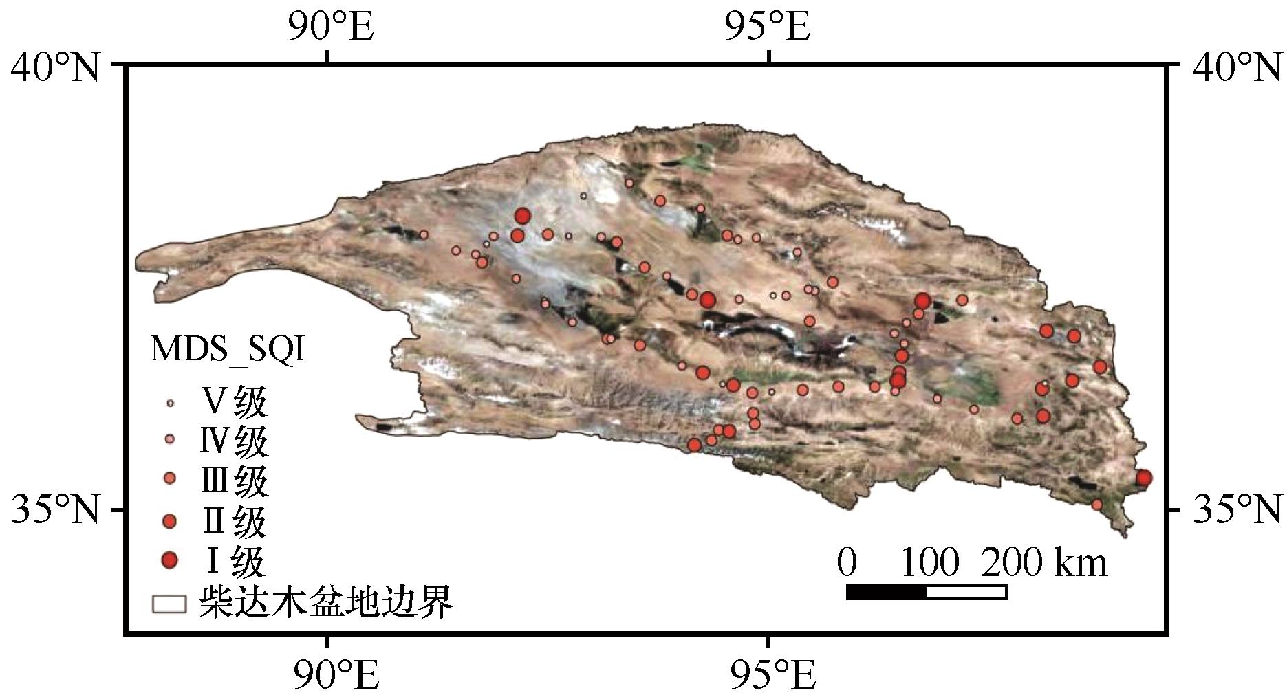
图3 柴达木盆地土壤质量等级空间分布
Fig.3 Spatial distribution of soil quality grade in Qaidam Basin
| 土壤指标 | 公因子方差 | 权重 |
|---|---|---|
| 容重 | 0.781 | 0.078 |
| pH值 | 0.552 | 0.055 |
| 碳酸钙 | 0.542 | 0.054 |
| 有机质 | 0.972 | 0.098 |
| 全氮 | 0.978 | 0.098 |
| 全磷 | 0.748 | 0.075 |
| 全钾 | 0.757 | 0.076 |
| 有效磷 | 0.723 | 0.073 |
| 速效钾 | 0.780 | 0.078 |
| 黏粒含量 | 0.581 | 0.058 |
| 粉粒含量 | 0.905 | 0.091 |
| 砂粒含量 | 0.880 | 0.088 |
| 砾石含量 | 0.764 | 0.077 |
表6 TDS指标及其权重
Table 6 TDS indicators and weights
| 土壤指标 | 公因子方差 | 权重 |
|---|---|---|
| 容重 | 0.781 | 0.078 |
| pH值 | 0.552 | 0.055 |
| 碳酸钙 | 0.542 | 0.054 |
| 有机质 | 0.972 | 0.098 |
| 全氮 | 0.978 | 0.098 |
| 全磷 | 0.748 | 0.075 |
| 全钾 | 0.757 | 0.076 |
| 有效磷 | 0.723 | 0.073 |
| 速效钾 | 0.780 | 0.078 |
| 黏粒含量 | 0.581 | 0.058 |
| 粉粒含量 | 0.905 | 0.091 |
| 砂粒含量 | 0.880 | 0.088 |
| 砾石含量 | 0.764 | 0.077 |
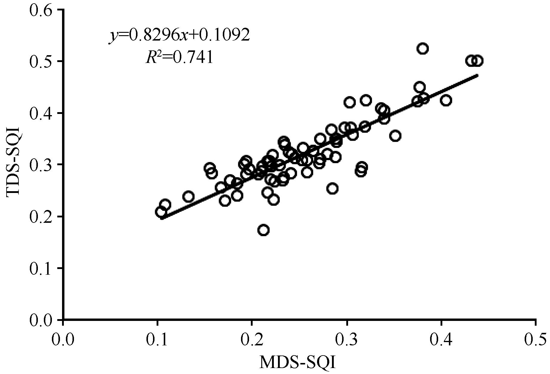
图4 MDS的适用性验证
Fig.4 Applicability validation of MDS
| 1 | Lehmann J, Bossio D A, Kogel-Knabner I,et al.The concept and future prospects of soil health[J].Nature Reviews Earth & Environment,2020,1(10):544-553. |
| 2 | 张桃林,潘剑君,赵其国.土壤质量研究进展与方向[J].土壤,1999,19(1):2-8. |
| 3 | 刘占锋,傅伯杰,刘国华,等.土壤质量与土壤质量指标及其评价[J].生态学报,2006(3):901-913. |
| 4 | Doran J W, Parkin T B.Defining and assessing soil quality[M]//Doran J W,Coleman D C,Bezdicek D F,et al.Defining and Assessing Soil Quality for a Sustainable Environment.SSSA Special Publication 35,American Society of Agronomy,1994:3-21. |
| 5 | 孙鸿烈,郑度,姚檀栋,等.青藏高原国家生态安全屏障保护与建设[J].地理学报,2012,67(1):3-12. |
| 6 | 王辉.玛曲高寒草甸沙化特征及沙化驱动机制研究[D].兰州:兰州大学,2007. |
| 7 | 王发科,苟日多杰,祁贵明,等.柴达木盆地气候变化对荒漠化的影响[J].干旱气象,2007(3):28-33. |
| 8 | 张福良,李青基,李积文,等.柴达木盆地水土流失现状及防治对策[J].中国水利,2012(18):43-44. |
| 9 | 陈发虎,汪亚峰,甄晓林,等.全球变化下的青藏高原环境影响及应对策略研究[J].中国藏学,2021(4):21-28. |
| 10 | 曹雪,焦菊英,李建军,等.青藏高原柴达木盆地东部地区的土壤侵蚀现状调查[J].水土保持通报,2021,41(5):1-8. |
| 11 | 张胜邦,董旭,刘玉璋,等.柴达木盆地东南部土壤风蚀研究[J].中国沙漠,1999,19(3):96-98. |
| 12 | 刘红英,董治宝.柴达木盆地雅丹形态特征及成因[J].中国沙漠,2019,39(3):214-220. |
| 13 | 丁召静.柴达木盆地雅丹释光年代学及其环境意义[D].北京:中国地质大学(北京),2020. |
| 14 | 赵串串,董旭,辛文荣,等.柴达木盆地土地沙漠化现状分析与治理对策研究[J].水土保持通报,2009,29(1):196-199. |
| 15 | 李鑫,张文菊,邬磊,等.土壤质量评价指标体系的构建及评价方法[J].中国农业科学,2021,54(14):3043-3056. |
| 16 | 张雪,孔范龙,姜志翔.基于生态功能的滨海湿地土壤质量综合评价方法构建及实证分析[J].环境科学,2022,43(5):2709-2718. |
| 17 | 刘文民,田鹏,刘利昆,等.青藏高原典型沙化区草地土壤质量评价[J].水土保持研究,2022,29(2):118-124. |
| 18 | 杨冲,王春燕,王文颖,等.青藏高原黄河源区高寒草地土壤营养特征变化及质量评价[J].生态环境学报,2022,31(5):896-908. |
| 19 | 奥勇,蒋嶺峰,白召弟,等.基于格网GIS的黄河流域土地生态质量综合评价[J].干旱区地理,2022,45(1):164-175. |
| 20 | 刘伟玮,刘某承,李文华,等.辽东山区林参复合经营土壤质量评价[J].生态学报,2017,37(8):2631-2641. |
| 21 | 李桂林,陈杰,檀满枝,等.基于土地利用变化建立土壤质量评价最小数据集[J].土壤学报,2008,45(1):16-25. |
| 22 | 李桂林,陈杰,孙志英,等.基于土壤特征和土地利用变化的土壤质量评价最小数据集确定[J].生态学报,2007,27(7):2715-2724. |
| 23 | 邓绍欢,曾令涛,关强,等.基于最小数据集的南方地区冷浸田土壤质量评价[J].土壤学报,2016,53(5):1326-1333. |
| 24 | 陈方正,任健,刘思涵,等.基于最小数据集的洞庭湖流域南部耕地土壤肥力综合评价[J].土壤通报,2021,52(6):1348-1359. |
| 25 | 朱鸣鸣,徐镀涵,陈光燕,等.基于最小数据集的喀斯特不同利用方式下土壤质量评价[J].草地学报,2021,29(10):2323-2331. |
| 26 | 廖程,王德伟,唐亮,等.基于最小数据集的成都平原某区土壤养分综合评价体系的构建[J].地球与环境,2021,49(2):189-197. |
| 27 | 王文武,朱万泽,李霞,等.基于最小数据集的大渡河干暖河谷典型植被土壤质量评价[J].中国水土保持科学(中英文),2021,19(6):54-59. |
| 28 | 刘利昆,赵广举,穆兴民,等.基于最小数据集的青藏公路沿线土壤质量评价[J].水土保持研究,2022,29(2):125-131. |
| 29 | 赵孝丹,颜雄,李文昭,等.基于CNKI数据库的土壤质量评价文献计量分析[J].河南农业,2021(35):56-58. |
| 30 | 白刚刚,赵瑛,陈菊林,等.柴达木盆地泥石流灾害特征与治理[J].青海大学学报,2016,34(5):58-62. |
| 31 | 刘秋漫.近30年来柴达木盆地遥感生态环境质量评价[D].西宁:青海师范大学,2020. |
| 32 | 辛莹,舒锴,戴黎聪,等.青藏高原柴达木盆地高寒荒漠土壤有机碳空间特征[J].中国草地学报,2021,43(11):113-118. |
| 33 | 张斯琦,陈辉,宋明华,等.2000-2015年柴达木盆地植被覆盖度时空变化及其与环境因子的关系[J].干旱区地理,2019,42(5):1124-1132. |
| 34 | 土壤检测第4部分:土壤容重的测定: [S]. |
| 35 | 土壤pH值的测定 电位法: [S]. |
| 36 | 森林土壤碳酸钙的测定: [S]. |
| 37 | 土壤检测第6部分:土壤有机质的测定: [S]. |
| 38 | 土壤检测第24部分:土壤全氮的测定 自动定氮仪法: [S]. |
| 39 | 段世航,崔若然,江荣风,等.激光衍射法测定土壤粒径分布的研究进展[J].土壤,2020,52(2):247-253. |
| 40 | 土壤全磷测定法: [S]. |
| 41 | 土壤 有效磷的测定 碳酸氢钠浸提-钼锑抗分光光度法: [S]. |
| 42 | 森林土壤钾的测定: [S]. |
| 43 | 刘金山,胡承孝,孙学成,等.基于最小数据集和模糊数学法的水旱轮作区土壤肥力质量评价[J].土壤通报,2012,43(5):1145-1150. |
| 44 | 全国土壤普查办公室. 中国土壤 [S].北京:中国农业出版社,1988. |
| 45 | 付贵全.生物炭对荒漠草地风沙土质量的影响研究[D].兰州:兰州大学,2022. |
| 46 | 李月梅.柴达木盆地枸杞种植区土壤养分空间变异特征[J].西南农业学报,2018,31(8):1643-1648. |
| 47 | 刘江,袁勤,张立欣,等.库布齐沙漠北缘不同人工灌木林地土壤肥力质量状况[J].西北林学院学报,2021,36(2):46-53. |
| 48 | 赵正,刘纯,尚明月,等.宁镇丘陵区村域小流域不同土壤景观下表土质量变化及评价[J].水土保持学报,2022,36(4):265-276. |
| 49 | 余坤,李国建,李百凤,等.不同秸秆还田方式对土壤质量改良效应的综合评价[J].干旱地区农业研究,2020,38(3):213-221. |
| 50 | 陈梦迪,陈奇伯,黎建强,等.枯落物不同输入方式对云南松林地土壤质量的影响评价[J].云南农业大学学报(自然科学),2020,35(1):149-155. |
| 51 | 高娃,景宇鹏,樊明寿,等.土默川平原盐渍化土地不同利用方式的土壤质量评价[J].中国土壤与肥料,2019(6):22-31. |
| 52 | 吴秀芝,刘秉儒,阎欣,等.荒漠草地土壤微生物生物量和微生物熵对沙漠化的响应[J].应用生态学报,2019,30(8):2691-2698. |
| 53 | 靳正忠,雷加强,徐新文,等.塔里木沙漠公路防护林土壤微生物生物量与土壤环境因子的关系[J].应用生态学报,2009,20(1):51-57. |
| 54 | 赵哈林,周瑞莲,苏永中,等.我国北方半干旱地区土壤的沙漠化演变过程与机制[J].水土保持学报,2007(3):1-5. |
| 55 | Jason P F, Jayne B, David D B,et al.The ecology of dust[J].Front of Ecological Environment,2010,8(8):423-430. |
| 56 | 丁国栋.风沙物理学[M].北京:中国林业出版社,2010:157-158. |
| 57 | Vogel C, Heister K, Buegger F,et al.Clay mineral composition modifies decomposition and sequestration of organic carbon and nitrogen in fine soil fractions[J].Biology and Fertility of Soils,2015,51(4):427-442. |
| 58 | 刘昀东,高广磊,丁国栋,等.风蚀荒漠化地区土壤质量演变研究进展[J].南京林业大学学报(自然科学版),2017,41(5):161-168. |
| 59 | 陈金凤,余世钦,符加方,等.华南红层地貌区不同利用方式土壤质量特征及其影响因素:以南雄盆地为例[J].生态环境学报,2022,31(5):918-930. |
| 60 | 俞海,黄季焜, Rozelle Scott,等.土壤肥力变化的社会经济影响因素分析[J].资源科学,2003(2):63-72. |
| 61 | Tan Z, Lal R, Owens L,et al. Distribution of light and heavey fractions of soil organic carbon as related to land use and tillage practice[J].Soil & Tillage Research,2007,92:53-59. |
| 62 | 曹鹤,薛立,谢腾芳,等.华南地区八种人工林的土壤物理性质[J].生态学杂志,2009,28(4):620-625. |
| 63 | 周波,高云华,张池,等.华南赤红壤地区4种不同耕作模式对土壤肥力属性的影响[J].华北农学报,2012,27():315-319. |
| 64 | 黄绍文,金继运,杨俐苹,等.县级区域粮田土壤养分空间变异与分区管理技术研究[J].土壤学报,2003,40(1):79-88. |
| 65 | 雷咏雯,危常州,李俊华,等.不同尺度下土壤养分空间变异特征的研究[J].土壤,2004,36(4):376-381. |
| 66 | 赵彦锋,史学正,于东升,等.小尺度土壤养分的空间变异及其影响因素探讨:以江苏省无锡市典型城乡交错区为例[J].土壤通报,2006,37(2):2214-2219. |
| 67 | 杨艳丽,史学正,于东升,等.区域尺度土壤养分空间变异及其影响因素研究[J].地理科学,2008,28(6):788-792. |
| 68 | 陈国平,程珊珊,丛明旸,等.三种阔叶林凋落物对下层土壤养分的影响[J].生态学杂志,2014,33(4):874-879. |
| 69 | 汉光昭,曹广超,曹生奎,等.高寒地区生态修复草地和林地土壤颗粒有机碳分解特征[J].中国沙漠,2022,42(5):36-43. |
| 70 | 王林林,刘普幸,王允.近14年来柴达木盆地NDVI时空变化及其影响因素[J].生态学杂志,2015,34(6):1713-1722. |
| 71 | 吕春艳,李旭,刘明歆,等.柴达木盆地1981-2017年降水及大气环流特征分析[J].沙漠与绿洲气象,2020,14(3):78-87. |
| 72 | 高三星保,许学莲,何爱兵,等.1961-2018年柴达木盆地大风日数变化特征[J].现代农业科技,2021(20):163-165. |
| 73 | 曹晓云,祝存兄,陈国茜,等.2000-2021年柴达木盆地地表绿度变化及地形分异研究[J].生态环境学报,2022,31(6):1080-1090. |
| 74 | 杜庆,孙世洲.柴达木盆地植被考察简况[J].植物生态学与地植物学丛刊,1981(1):77-78. |
| [1] | 张潇, 严平, 董苗, 刘小槺, 袁文杰, 王晓旭. 柴达木盆地托拉海河下游复合新月形沙丘沉积构造探地雷达探测初步结果[J]. 中国沙漠, 2023, 43(1): 160-168. |
| [2] | 邹桐, 杨转玲, 韦锦芝, 廖应英, 邢学刚, 钱广强, 梁晓磊. 柴达木盆地西南缘新月形沙丘移动特征及其影响因素[J]. 中国沙漠, 2023, 43(1): 212-221. |
| [3] | 张思悦, 李继彦, 张姚姚, 徐德华. 柴达木盆地西南缘山前沙丘区沉积物地球化学特征及其指示意义[J]. 中国沙漠, 2023, 43(1): 222-233. |
| [4] | 屈欣, 郜学敏, 王萌, 罗怡坤, 李继彦. 柴达木盆地地质遗迹资源评价[J]. 中国沙漠, 2022, 42(1): 167-174. |
| [5] | 李继彦, 郜学敏, 董治宝. 柴达木盆地雅丹地貌区风况数据集[J]. 中国沙漠, 2021, 41(6): 265-268. |
| [6] | 王萌, 郜学敏, 屈欣, 张思悦, 张姚姚, 陈冠春, 李继彦. 柴达木盆地西南缘山前沙丘区沙丘地貌形态特征[J]. 中国沙漠, 2021, 41(5): 166-174. |
| [7] | 郜学敏, 屈欣, 王萌, 张思悦, 张姚姚, 李继彦. 柴达木盆地西北部长垄状雅丹沉积物地球化学元素组成及指示意义[J]. 中国沙漠, 2021, 41(3): 127-136. |
| [8] | 曹敏, 于禄鹏, 安萍, 董治宝, 赵俊香, 赖忠平, 王昌盛. 察尔汗盐湖区线形沙丘下伏湖相地层的释光年代及其环境意义[J]. 中国沙漠, 2021, 41(1): 101-110. |
| [9] | 梁准, 吕萍, 刘铮瑶, 肖南, 梁玮, 许明静, 冯淼彦. 柴达木盆地鸭湖地区风况特征与雅丹地貌形态关系[J]. 中国沙漠, 2020, 40(5): 42-48. |
| [10] | 王梓莎, 苗运法, 赵永涛, 李芳, 雷艳, 向明星, 邹亚国. 柴达木盆地北缘湖泊表层沉积物炭屑特征及其环境意义[J]. 中国沙漠, 2020, 40(4): 10-17. |
| [11] | 陈宗颜, 董治宝, 汪青春, 鄂崇毅, 刘飞. 柴达木盆地风况及输沙势特征[J]. 中国沙漠, 2020, 40(1): 195-203. |
| [12] | 马芳, 吕萍. 新月形沙丘与线性沙丘共存区域风况特征[J]. 中国沙漠, 2019, 39(3): 98-106. |
| [13] | 刘红英, 董治宝. 柴达木盆地雅丹形态特征及成因[J]. 中国沙漠, 2019, 39(3): 214-220. |
| [14] | 郜学敏, 董治宝, 段争虎, 崔徐甲, 刘铮瑶, 陈国祥, 张彩霞. 柴达木盆地西北部长垄状雅丹沉积物粒度特征[J]. 中国沙漠, 2019, 39(2): 79-85. |
| [15] | 李璠, 肖建设, 祁栋林, 李林. 柴达木盆地沙尘暴天气影响因素[J]. 中国沙漠, 2019, 39(2): 144-150. |
| 阅读次数 | ||||||
|
全文 |
|
|||||
|
摘要 |
|
|||||
©2018中国沙漠 编辑部
地址: 兰州市天水中路8号 (730000)
电话:0931-8267545
Email:caiedit@lzb.ac.cn;desert@lzb.ac.cn

 甘公网安备 62010202000688号