| 1 |
Adger W N, Benjaminsen T A, Brown K,et al.Advancing a political ecology of global environmental discourses[J].Development and Change,2001,32(4):681-715.
|
| 2 |
王涛,朱震达.我国沙漠化研究的若干问题:1.沙漠化的概念及其内涵[J].中国沙漠,2003,23(3):3-8.
|
| 3 |
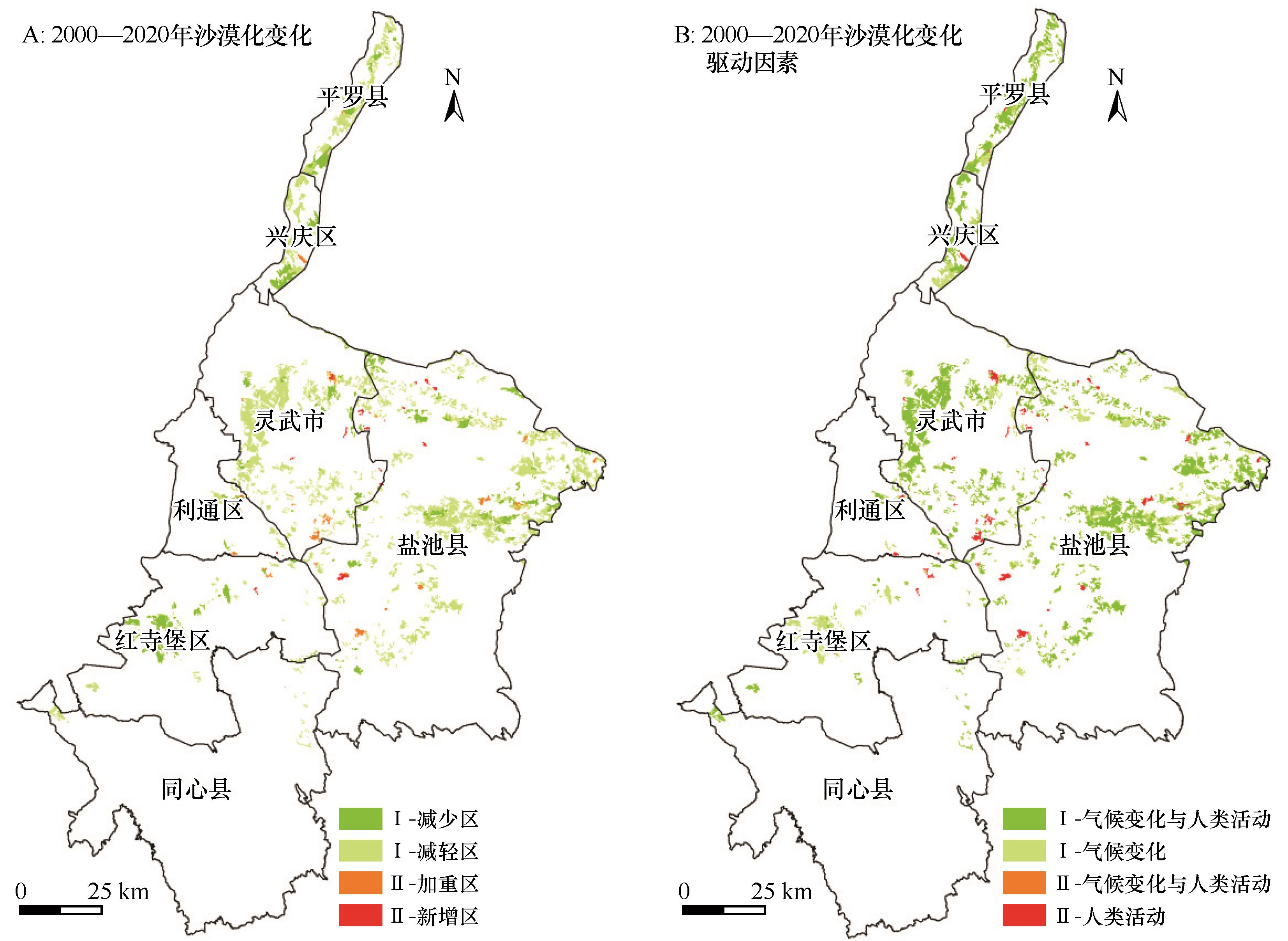
Reynolds J F, Stafford S D M, Lambin E F,et al.Global desertification:building a science for dryland development[J].Science,2007,316(5826):847-851.
|
| 4 |
王涛.中国防沙治沙实践与沙漠科学发展的70年:Ⅰ.初创篇[J].中国沙漠,2022,42(1):1-4.
|
| 5 |
王东清,温学飞,许浩.宁夏沙漠化土地动态监测研究[J].中国农学通报,2018,34(19):96-101.
|
| 6 |
朱震达,刘恕.中国的沙漠化及其治理[M].北京:科学出版社,1989.
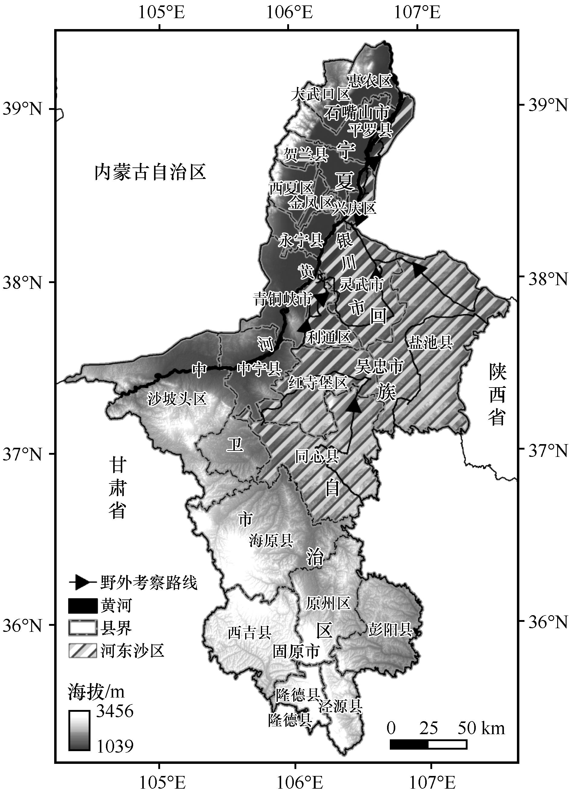
|
| 7 |
许端阳,康相武,刘志丽,等.气候变化和人类活动在鄂尔多斯地区沙漠化过程中的相对作用研究[J].中国科学(D辑:地球科学),2009,39(4):516-528.
|
| 8 |
Xu D Y, Li C L, Zhuang D F,et al.Assessment of the relative role of climate change and human activities in desertification:a review[J].Journal of Geographical Sciences,2011,21(5):926-936.
|
| 9 |
Xie J L, Lu Z X, Feng K.Effects of climate change and human activities on aeolian desertification reversal in Mu Us Sandy Land,China[J].Sustainability,2022,14(3):su14031669.
|
| 10 |
王一谋.沙漠化遥感数字图象处理试验研究[J].中国沙漠,1989,9(1):137-141.
|
| 11 |
李亚云,杨秀春,朱晓华,等.遥感技术在中国土地荒漠化监测中的应用进展[J].地理科学进展,2009,28(1):55-62.
|
| 12 |
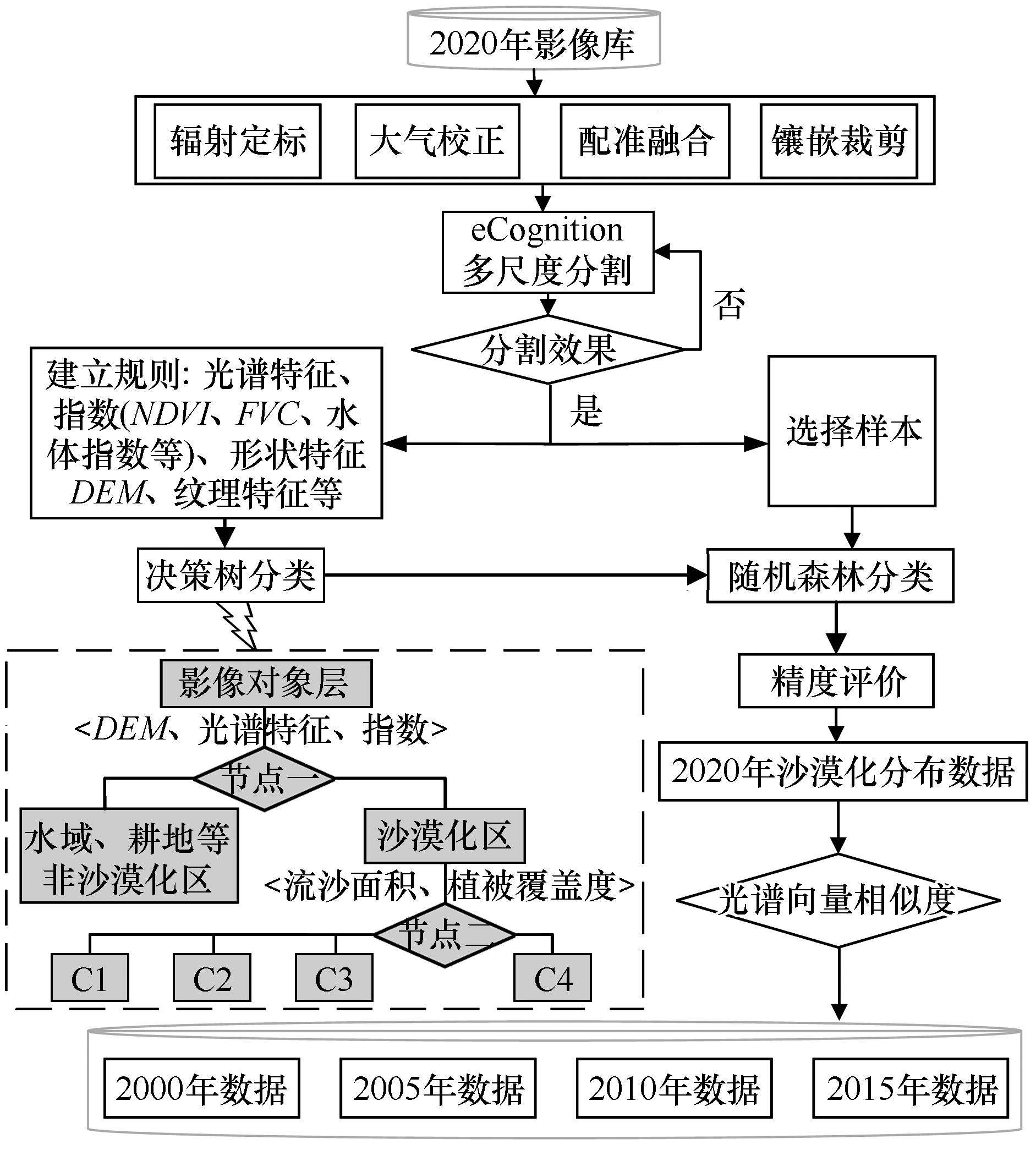
董光荣,高尚玉,金炯,等.青海共和盆地土地沙漠化及其防治[J].中国沙漠,1989,9(1):64-78.
|
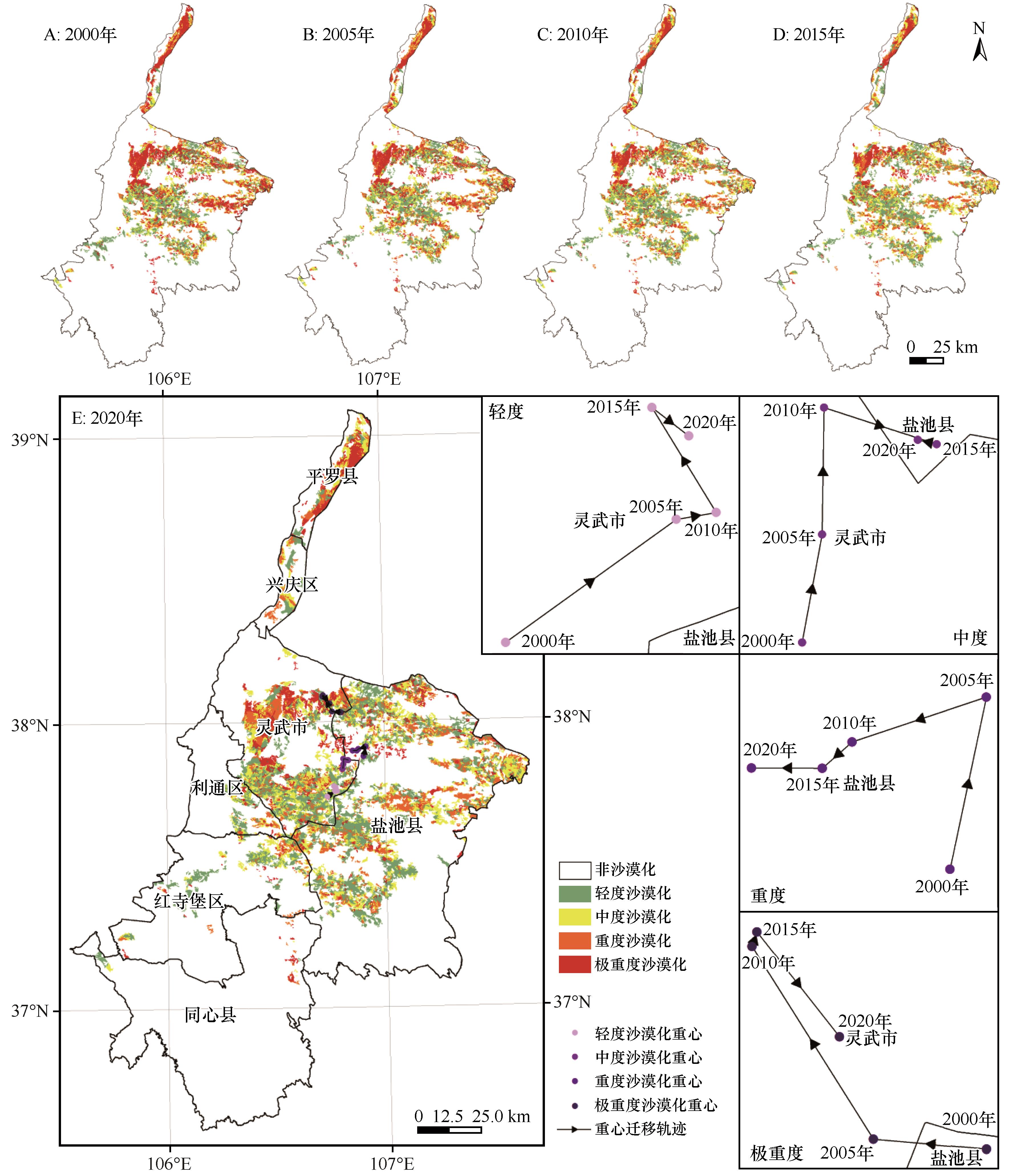
| 13 |
刘爱霞,王长耀,刘正军,等.基于NOAA时间序列数据分析的中国西部荒漠化监测[J].武汉大学学报(信息科学版),2004(10):924-927.
|
| 14 |
UNCCD.United Nations Convention to Combat Desertification[R].1994.
|
| 15 |
周雷,才吉.黄河上游土地沙漠化驱动因素定量研究:以共和盆地土地沙漠化为例[J].中国草食动物,2011,31(1):46-49.
|
| 16 |
Wessels K J, Prince S D, Malherbe J,et al.Can human-induced land degradation be distinguished from the effects of rainfall variability?A case study in South Africa[J].Journal of Arid Environments,2007,68(2):271-297.
|
| 17 |
何彤慧,王乃昂,黄银洲,等.宁夏河东沙地历史时期沙漠化过程新探[J].宁夏社会科学,2008(2):108-111.
|
| 18 |
周立华,刘洋.中国生态建设回顾与展望[J].生态学报,2021,41(8):3306-3314.
|
| 19 |
侯仁之.从人类活动的遗迹探索宁夏河东沙区的变迁[J].科学通报,1964,9(3):226-231.
|
| 20 |
徐俊名.宁夏河东沙区沙丘沙的来源[J].地理学报,1965(2):142-156.
|
| 21 |
汪一鸣.宁夏中部风沙区的环境演变[J].干旱区资源与环境,2004,18(4):7-12.
|
| 22 |
张维慎.试论宁夏中北部土地沙化的历史演进[J].古今农业,2005(1):94-100.
|
| 23 |
王娅,周立华,路慧玲,等.城镇化进程对沙漠化逆转趋势影响的动态计量分析:以宁夏盐池县为例[J].中国沙漠,2017,37(5):867-877.
|
| 24 |
马兵,周立华,路慧玲,等.基于意愿价值评估法的禁牧政策生态补偿定量分析:以宁夏盐池县为例[J].中国沙漠,2015,35(5):800-807.
|
| 25 |
王娅,周立华,陈勇,等.农户生计资本与沙漠化逆转趋势的关系:以宁夏盐池县为例[J].生态学报,2017,37( 6):2080-2092.
|
| 26 |
温学飞,赵向锋,温建军,基于因子分析法的盐池县沙漠化土地动态变化影响因素研究 [J].宁夏农林科技,2015,56(11):68-72.
|
| 27 |
要永在,李庆和,杨光.基于IIDD的盐池县土地荒漠化动态变化研究[J].内蒙古农业大学学报,2013,34(1):61-65.
|
| 28 |
王娅,周立华,魏轩.基于社会-生态系统的沙漠化逆转过程脆弱性评价指标体系[J].生态学报,2018,38(3):829-840.
|
| 29 |
董晓朋,李振宏,黄婷,等.宁夏红寺堡盆地隐伏古隆起成因机制及其对区域沙漠化的影响[J].地球科学与环境学报,2020,42(5):688-700.
|
| 30 |
黄婷,李振宏,刘锋,等.宁夏红寺堡盆地地表沙漠化现状及其地质主控因素[J].地质力学学报,2018,24(4):505-514.
|
| 31 |
王涛,吴薇,薛娴,等.近50年来中国北方沙漠化土地的时空变化[J].地理学报,2004(2):203-212.
|
| 32 |
李苗苗.植被覆盖度的遥感估算方法研究[D].北京:中国科学院研究生院(遥感应用研究所),2003.
|
| 33 |
Duan H C, Wang T, Xue X,et al.Dynamic monitoring of aeolian desertification based on multiple indicators in Horqin Sandy Land,China[J].Science of the Total Environment,2019,650:2374-2388.
|
| 34 |
谢家丽,颜长珍,常存.1990-2010年中国西北地区土地覆被数据集[J].中国科学数据(中英文网络版),2018,4(3):86-96.
|
| 35 |
宋翔,颜长珍.基于知识库的像斑光谱向量相似度土地覆盖变化检测方法[J].生态学报,2014,34(24):7175-7180.
|
| 36 |
雷延金.理解“重心”意,巧解相关题[J].地理教学,2010(13):50-51.
|
| 37 |
Duan H C, Yan C Z, Tsunekawa A,et al.Assessing vegetation dynamics in the Three-North Shelter Forest region of China using AVHRR NDVI data[J].Environmental Earth Sciences,2011,64(4):1011-1020.
|
| 38 |
冯起,白光祖,李宗省,等.加快构建西北地区生态保护新格局[J].中国科学院院刊,2022,37(10):1457-1470.
|
| 39 |
程彦培,陈立,张琳,等.盐池县沙漠化土地动态变化影响因素分析[J].中国水土保持,2010(11):34-37.
|
| 40 |
马永欢,周立华,朱艳玲,等.近 50年来盐池县土地沙漠化驱动因素的时间变化[J].干旱区研究,2009,26(2):249-254.
|
| 41 |
黄发平,何彤慧.宁夏河东沙地历史时期水环境变化的现代启示[C]//经济发展方式转变与自主创新:第十二届中国科学技术协会年会(第一卷).2010.
|
 ), 岳新斌1, 谢家丽3,4(
 甘公网安备 62010202000688号