img

官方微信

高级检索

中国沙漠 ›› 2026, Vol. 46 ›› Issue (5): 335-345.DOI: 10.7522/j.issn.1000-694X.2026.00021

• • 上一篇    

2000—2024年“三北”工程核心攻坚区土壤风蚀特征及其驱动因素

李庆1,2(), 张春来3, 王洪涛4, 贾文茹5, 王仁德1,2, 张斯琦1,2(), 苑依笑1,2, 付刚1,2   

  1. 1.河北省科学院地理科学研究所/河北省地理信息开发应用技术创新中心,河北 石家庄 050011
    2.生态环境部 生态质量综合监测站 河北坝上农牧交错带站(草地),河北 承德 068450
    3.北京师范大学,北京 100875
    4.中国科学院西北生态环境资源研究院,甘肃 兰州 730000
    5.中国科学院新疆生态与地理研究所,新疆 乌鲁木齐 830011
  • 收稿日期:2025-12-04 修回日期:2026-02-02 出版日期:2026-09-20 发布日期:2026-11-02
  • 通讯作者: 张斯琦
  • 作者简介:李庆(1986—),男,山东金乡人,博士,研究员,研究方向为土壤风蚀与沙漠化。E-mail: qingli2020@outlook.com
  • 基金资助:
    国家自然科学基金项目(41801007);河北省科学院基本科研业务费制度试点项目(2024PF11)

Spatio-temporal distribution of soil wind erosion and its driving factors in the key combat zone of the Three-North Shelterbelt Forest Program during 2000-2024

Qing Li1,2(), Chunlai Zhang3, Hongtao Wang4, Wenru Jia5, Rende Wang1,2, Siqi Zhang1,2(), Yixiao Yuan1,2, Gang Fu1,2   

  1. 1.Institute of Geographical Sciences / Hebei Technology Innovation Center for Geographic Information Application,Hebei Academy of Sciences,Shijiazhuang 050011,China
    2.Station of Agro-pastoral Ecotone in Bashang Hebei (Grassland),Ecological Quality Comprehensive Monitoring Station,Ministry of Ecology and Enviroment,Chengde 068450,Hebei,China
    3.Beijing Normal University,Beijing 100875,China
    4.Northwest Institute of Eco-Environment and Resources,Chinese Academy of Sciences,Lanzhou 730000,China
    5.Xinjiang Institute of Geography and Ecology,Chinese Academy of Sciences,Urumqi 830011,China
  • Received:2025-12-04 Revised:2026-02-02 Online:2026-09-20 Published:2026-11-02
  • Contact: Siqi Zhang

摘要:

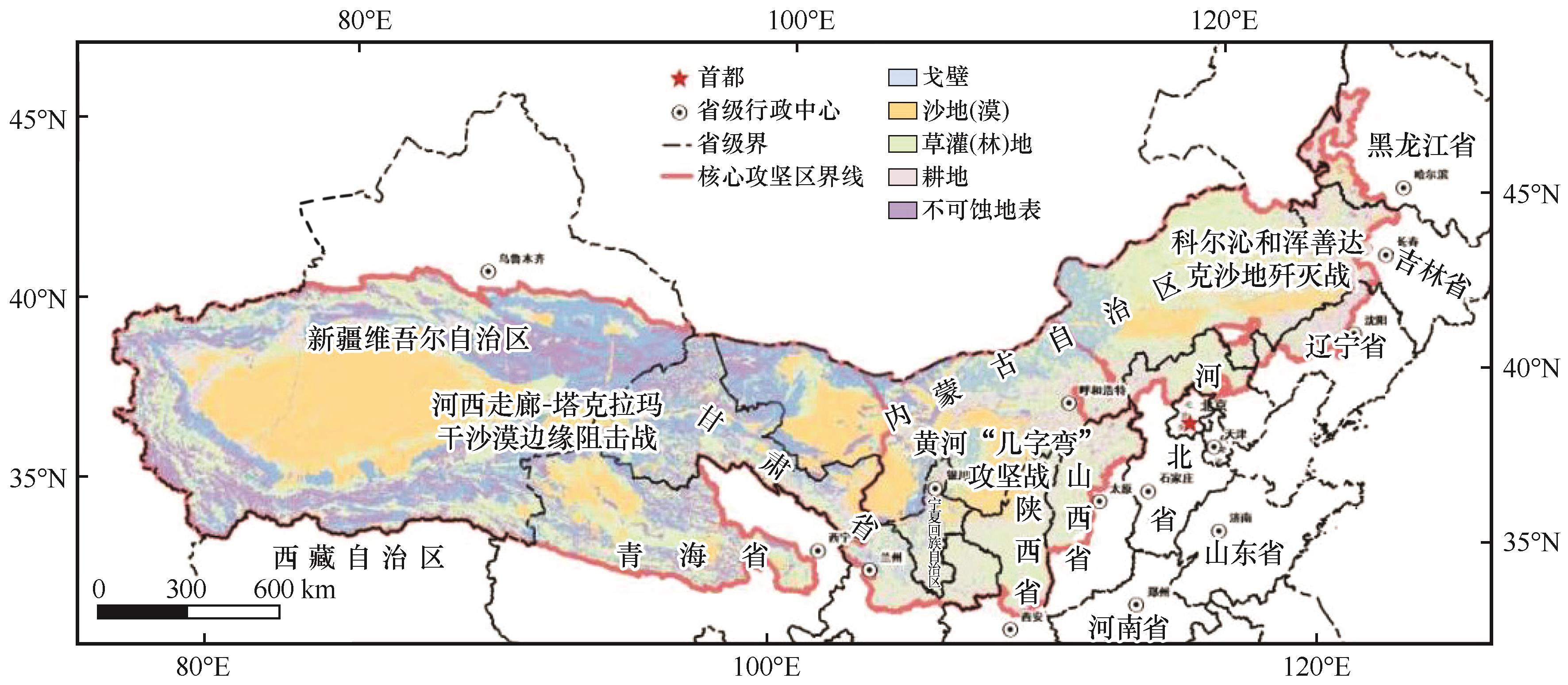
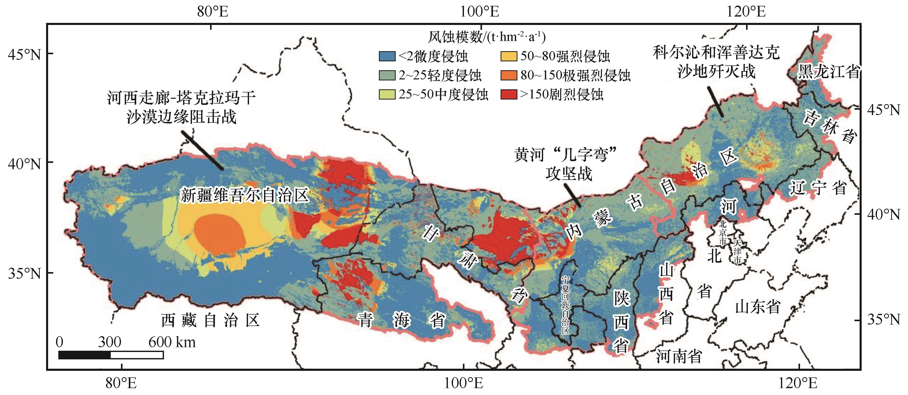
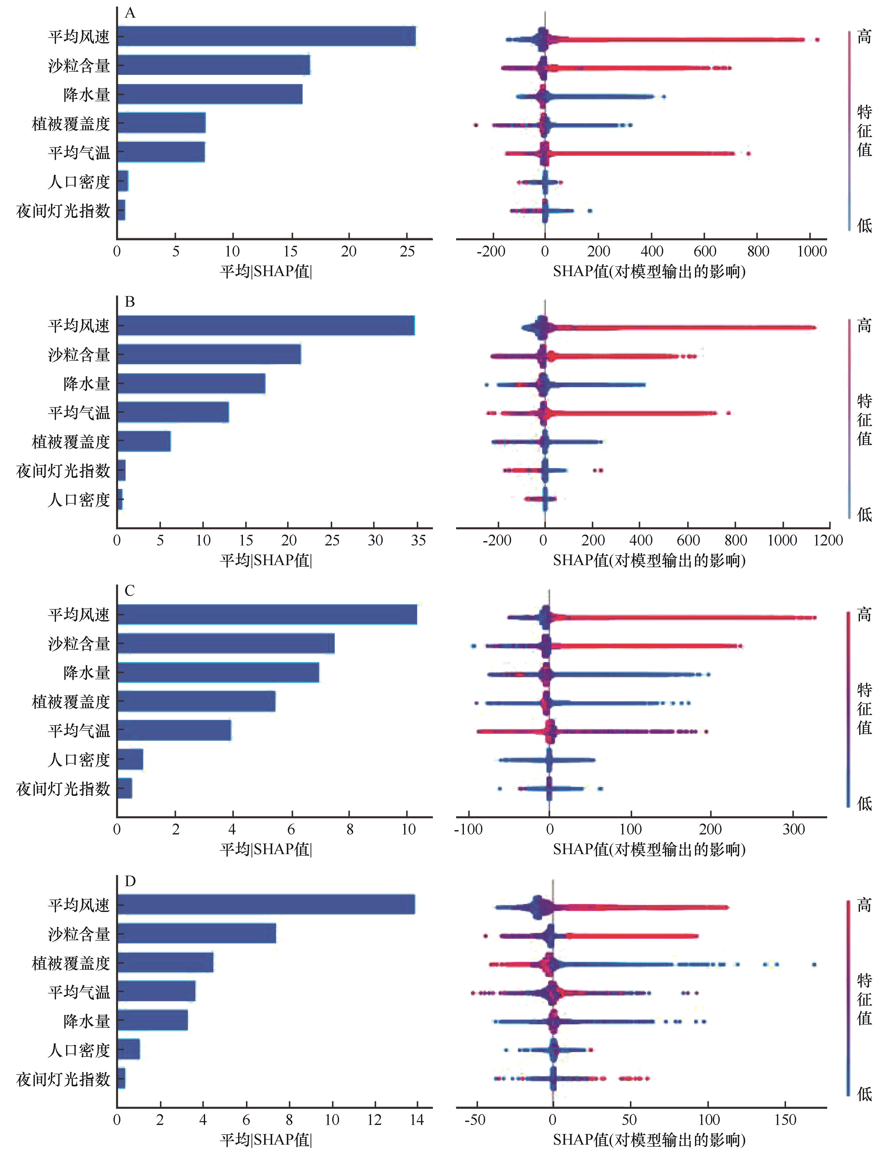
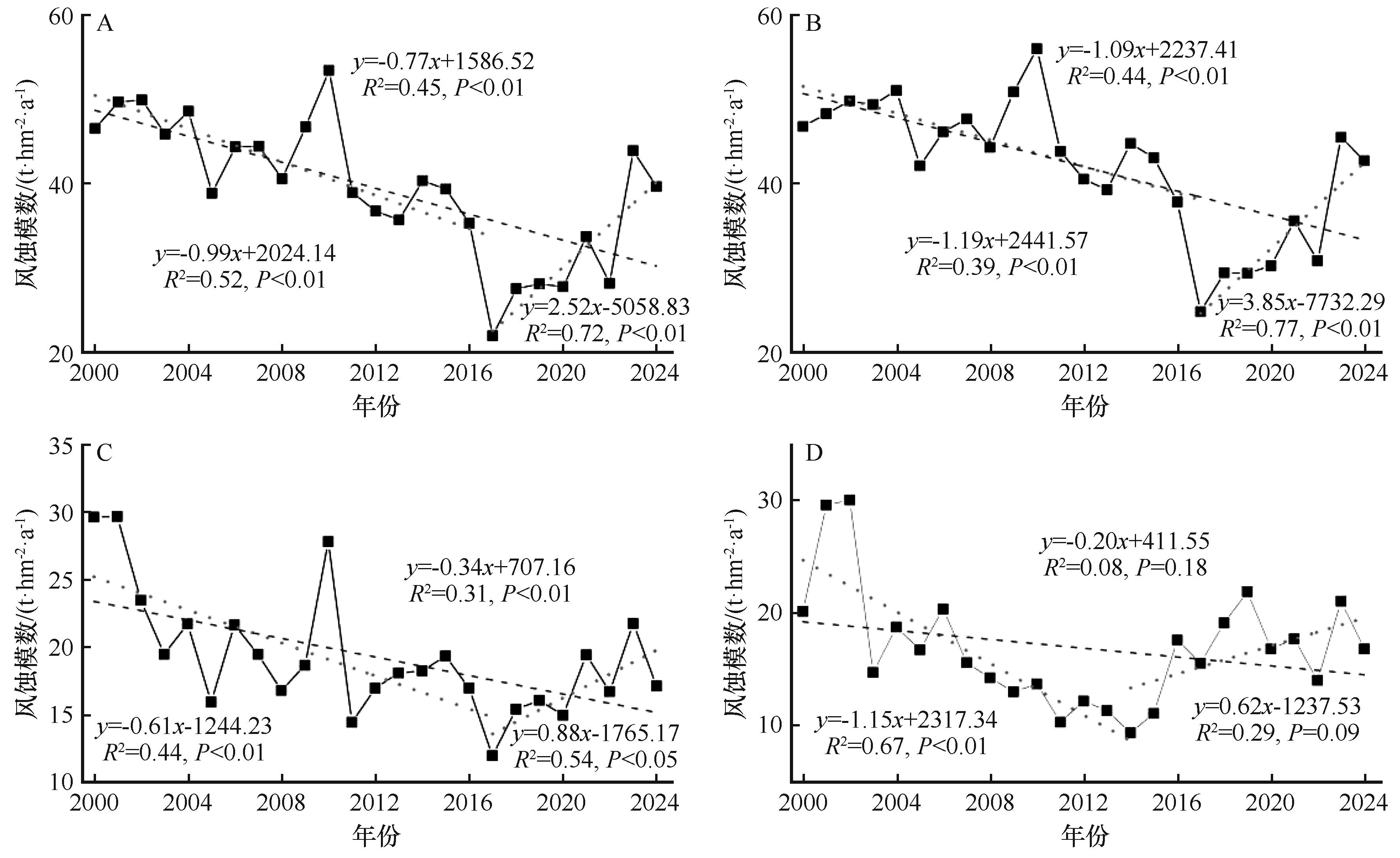
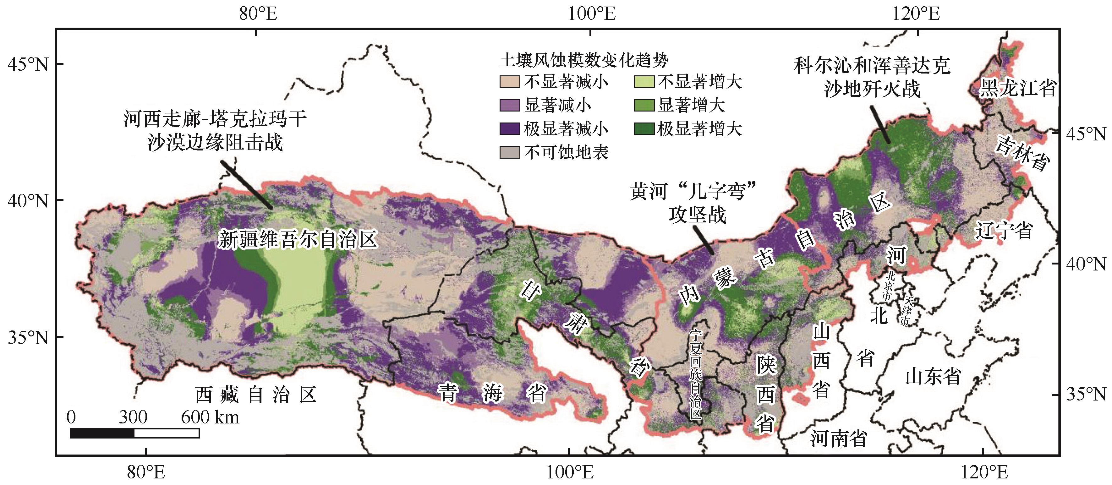
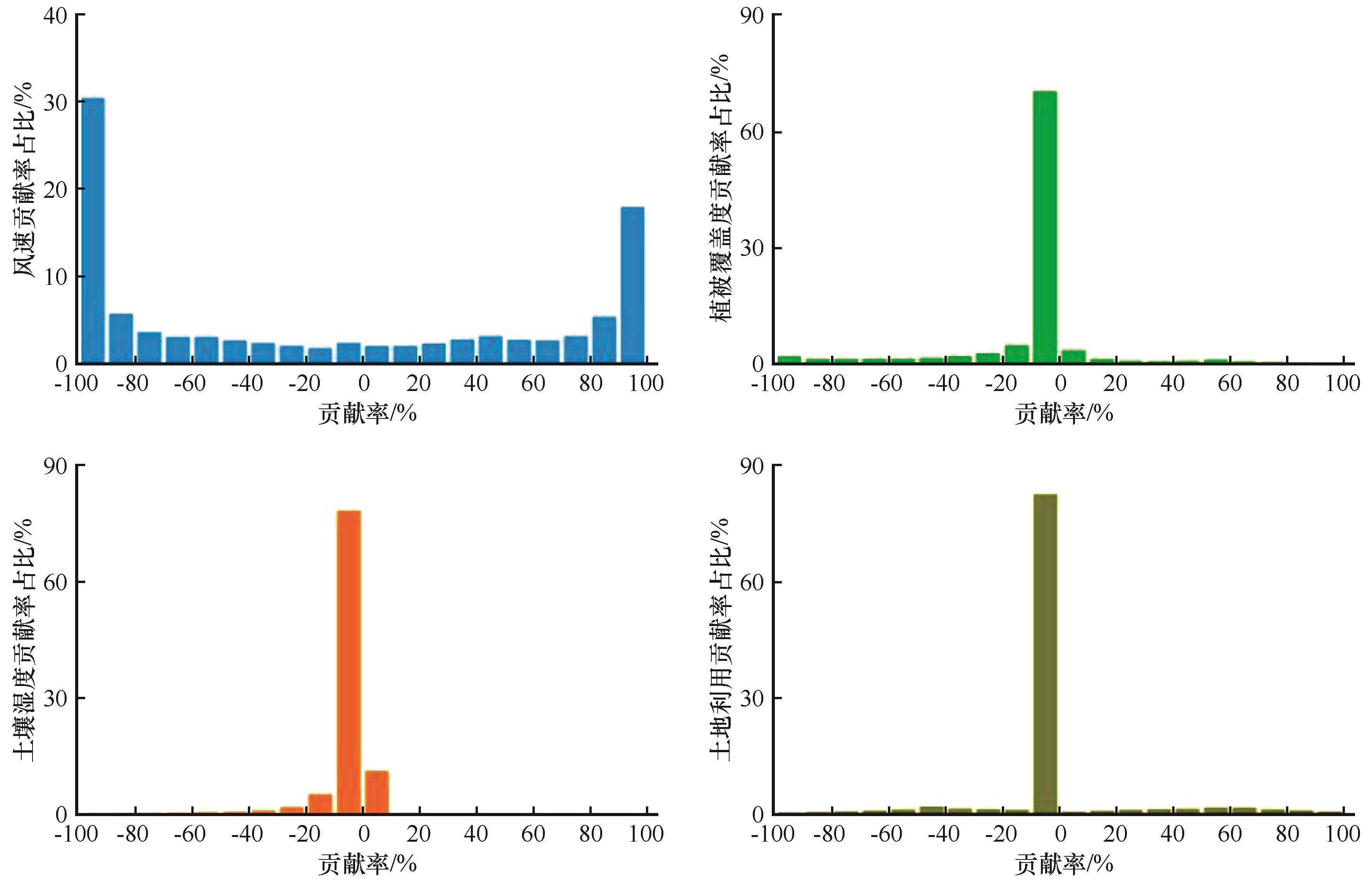
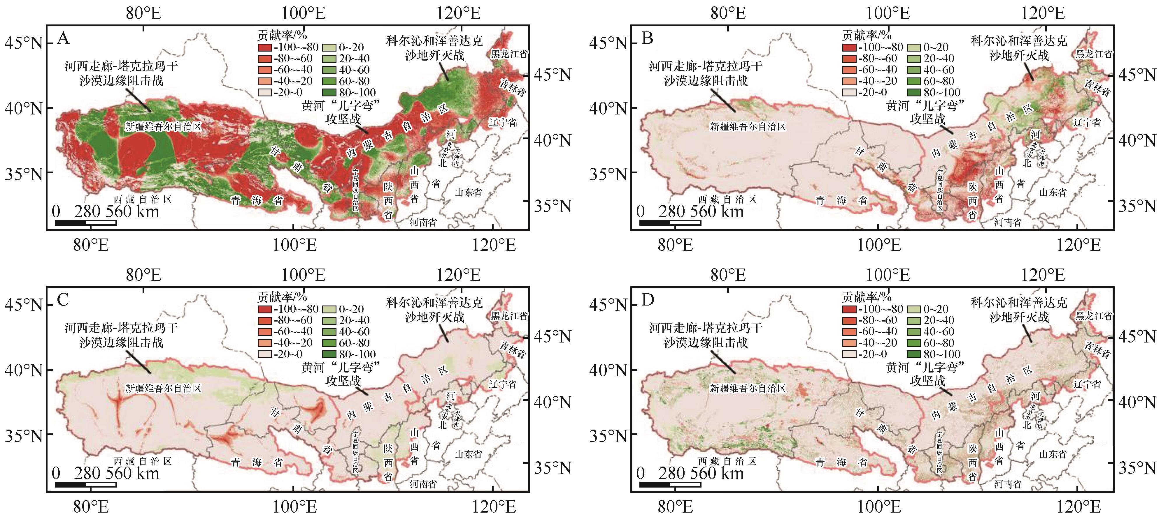
“三北”工程核心攻坚区是“三北”工程六期的核心治理区,认清区内土壤风蚀状况是科学防治土壤风蚀危害的基础。本研究综合采用修订第一次全国水利普查风蚀模型、非参数趋势分析、极端梯度提升(XGBoost)模型和控制变量法,核算了2000—2024年核心攻坚区土壤风蚀模数,分析了土壤风蚀时空演化特征及其驱动因素。结果表明:核心攻坚区平均土壤风蚀模数39.47 t·hm-2·a-1,以微度和轻度风蚀为主。区内强烈及其以上等级风蚀区占区域总面积的11.47%,主要分布在区内气候干旱、风力较大的沙漠和沙地区,自然因子是控制其空间分布的关键。25年来,核心攻坚区土壤风蚀模数整体呈显著减少趋势,年均减小速率为0.77 t·hm-2·a-2。空间上,土壤风蚀模数呈减小趋势和增大趋势的区域面积分别占总面积的49.15%和23.57%。风速控制了大部分地区土壤风蚀的变化。

关键词: “三北”工程, 核心攻坚区, 土壤风蚀, 时空分布格局

Abstract:

The key combat zone is the key ecological restoration region of the Three-North Shelterbelt Program (Phase Ⅵ). A comprehensive understanding the status of soil wind erosion is essential for developing effective prevention and control strategies. This study utilized a revised wind erosion model from China's first national soil erosion survey, non-parametric trend analysis, extreme gradient boosting (XGBoost) model, and controlled variable method to calculate the soil wind erosion modulus in the key combat zone between 2000 and 2024, and analyzed the spatiotemporal evolution patterns of wind erosion and its driving factors. Results show that the average wind erosion modulus is 39.47 t·hm-2·a-1 in the key combat zone. The area of strong, extremely strong and severe wind erosion cover 346 352 km², accounting for 11.47% of the total area, primarily distributed in the Taklimakan Desert, Kumtag Desert, Qaidam Desert, Badain Jaran Desert, Tengger Desert, Ulan Buh Desert, and the western part of the Hunshandake Sandy Land. Natural factors control the spatial distribution of soil wind erosion. Over the past 25 years, the soil wind erosion modulus exhibited a significant decreasing trend throughout the key combat zone, with an average annual decrease rate of 0.77 t·hm-2·a-1. The areas with decreasing and increasing wind erosion modulus account for 49.15% and 23.57% of the total area, respectively. Wind speed controls the change of wind erosion across most regions.

Key words: Three-North Shelterbelt Forest Program, key combat zone, soil wind erosion, spatio-temporal distribution

中图分类号: